Note: Descriptions are shown in the official language in which they were submitted.
CA 02339924 2001-02-05
WO 00/54076 PCT/CA00I00235
1 ARTICULATED ROBOTIC SCANNER
2
3 FIELD OF THE INVENTION
4 The invention relates to an apparatus and process for the
detection of mines. More specifically a robotic vehicle is provided with an
6 articulated arm for supporting mine-detecting and range-finding sensors.
7
8 BACKGROUND OF THE INVENTION
9 A number of technologies have been applied to the ground-based
detection of landmines. !n the simplest instance is the individual armed with
11 only a hand-held prodder for probing the ground and relying upon their
12 experience to gauge the level of hazard associated with a contacted object.
13 Hand-held electronic mine detectors are an improvement, but, the proximity
of
14 the operator to the detector still presents a risk. At the other extreme
are
complex and expensive remote-controlled vehicles with sensor arrays
16 preceded by a preconditioning flail vehicle to remove anti-personnel mines.
17 These vehicle mounted sensor detectors are ideal for level terrain,
particularly
18 road services.
19 Vehicle-mounted detectors are rapid but are expensive and
operate poorly in irregular and generally difficult terrain and tend to
utilize at
21 least one sensor which contacts the ground which can trigger a mine if not
pre-
22 cleared. Hand-held detectors are intended for and are used in terrain that
23 vehicle-mounted detectors cannot reach.
SUBSTITUTE SHEET (RULE 26)
CA 02339924 2001-02-05
WO 00/54076 PCT/CA00/00235
1 (t is known that in order to decommission any terrain and render it
2 safe for passage of personnel or resumption of regular human activity, all
3 landmines must be removed. This typically needs to be accomplished with
4 painstaking and hazardous hand-work.
Hand-held mine or metal detectors typically comprise a
6 component box with a handle, a rigid shaft extending towards the ground, and
7 a sensor located at the end of the rigid shaft. The operator typically holds
the
8 detector used by the handle and swings the sensor over the ground in a left
9 right sweeping action as the operator walks forward. The advantages of the
hand-held detectors include the ability to sweep the ground profile with the
11 detector head spaced closely from the ground for optimal detection, yet the
12 operator strives to prevent contacting either the ground or any objects on
or in
13 the ground. The operator's shoulder, arm and wrist provide great
flexibility in
14 maintaining this sensor spacing. This flexibility permits a human operator
to
very carefully and precisely sweep and area regardless of its terrain.
16 Further, the operator is able to vary the width of the sweep in
17 order to adapt to a particular situation or terrain. The disadvantages
include is
18 that the hand held method is slow, personnel intensive, tiring, hazardous
and
19 obviously stressful for the operator.
It is an objective therefore to provide a mine detection system
21 which implements the flexibility of the hand-held system, provides faster
and
22 positive detection of mines and incorporates some of the safer and more
rapid
23 mechanized scanning capabilities of the vehicle mounted systems.
24
2
CA 02339924 2001-02-05
WO 00/54076 PCTICA00/00235
1 SUMMARY OF THE INVENTION
2 Generally, a small, and simple articulated robotic scanner is
3 provided which is capable both of performing the effective non-contacting
and
4 efficient ground-sweeping technique usually performed by human personnel
and hand-held mine detectors, yet does so without the imposition of fatigue
and
6 risk upon personnel. The apparatus, while more complex than either a hand
7 prodder or hand-held metal detector, is significantly less expensive or
complex
8 than the multisensor, vehicle-mounted apparatus. Additionally, it can access
9 and decommission terrain that the larger vehicles cannot.
Generally, the robotic scanner comprises an articulated arm
11 having one or more mine detectors mounted at its distal end. The arm is
12 mounted to any locamotion device, such as a small robot. The arm is used in
13 an automatic or semi-automatic fashion for repetitively sweeping the mine
14 detector in ever forward advancing side-to-side arcs over the terrain. The
sensors are maintained in closely spaced relationship to the ground for
optimal
16 mine detection. The spacing of the detector to the ground is determined
with a
17 combination of terrain range-finding sensors and a controller for
maintaining the
18 relative position of the ground and the mine detector. Accordingly, while
the
19 mine detector is swept over the terrain, its position is dynamically
adjusted to
maintain a constant separation from the ground without contacting the ground
21 or any objects.
22 In a broad apparatus aspect, mine-detecting apparatus is
23 provided for mounting to a vehicle travelling forward to traversing the
ground
24 comprising:
3
CA 02339924 2001-02-05
WO 00/54076 PCT/CA00/00235
1 ~ a detector arm connected to the vehicle at one end and to a
2 mine detector at the other;
3 ~ a joint having two or more rotational axes for connecting the
4 detector arm to the vehicle, said joint being robotic-actuated
for enabling tilt and side-to-side panning movement of the
6 detector arm;
7 ~ range-finding sensors for determining the distance of the
8 range-finding sensors to the ground ahead of the panning
9 mine detector;
~ positional sensors for tracking the position of the mine
11 detector
12 ~ a first controller for analyzing the range-finding sensors and
13 positional sensors for determining the relative location of the
14 mine detector and the ground; and
1 b ~ a second controller for dynamically adjusting the tilt of the
16 detector arm and position of the mine detector so as to
17 continually ensure it is spaced from the ground as it is panned
18 over the ground.
19 fn a preferred embodiment, the mine detector is a metal detector
and accordingly, the range-finding sensors are supported on a second arm for
21 separating the potentially metal-containing range-finding sensors from the
22 metal detector. More preferably, the second arm can be re-positioned as
23 necessary to positioned it above, to the side and ahead of the panning
metal
24 detector.
4
CA 02339924 2001-02-05
WO 00/54076 PCT/CA00/00235
1 Further, it is preferable to use two or more range-finding sensors
2 such as a laser range-finder and ultrasonic sensors in combination to
improve
3 confidence levels and respond to a greater number of environmental factors.
4 More preferably, control is enhanced if the detector arm is extendible for
performing a series of side-to-side pans rather than continually repositioning
6 the vehicle.
7 The apparatus enables practice of a novel method of mine
8 detection broadly comprising the steps of
9 providing a vehicle having an articulated member mounted
to
the vehicle and having a mine detector mounted at the
far
11 end;
12 continuously determining the spacing between the mine
13 detector and the ground;
14 actuating the member to pan the mine detector laterally
from
side to side to scan a arcuate region; all the while
18 adjusting the position of the mine detector so as to
maintain a
17 space between the mine detector and the ground; and
18 advancing the articulated member as necessary to scan
a new
19 arcuate region.
5
CA 02339924 2001-02-05
WO 00/54076 PCTICA00/00235
1 BRIEF DESCRIPTION OF THE DRAWINGS
2 Figure 1 is an isometric view of a robotic scanner comprising a
3 small tele-operated vehicle having both an articulated, mine detector
supporting
4 arm and a terrain mapping sensor-supporting arm mounted thereto, the arm
shown panning in a left-to-right direction;
6 Figure 2a; 2b and 2c present top, side and front orthographic
7 views of the robotic scanner of Fig. 1;
8 Figure 3a and 3b are plan views of the scanned region illustration
9 the LRF scanning line segment preceding the mine detector for right-to-left
and
the right-to-left panning respectively;
11 Figure 4 is a schematic representation of the kinematic structure
12 of the detector and LRF arms and associated sensors;
13 Figure b is a plan view of the vehicle, detector arm and LRF arm.
14 The solids lines illustrate the arms at their leftmost range of motion in
preparation to scan right. The hidden lines illustrate the vehicle advanced
16 forward an increment and the arms positioned at their leftmost range of
motion
17 in preparation to scan left; and
18 Figure S is a front view showing three snapshots of the mine
19 detector and detector arm during panning while maintaining a fixed spacing
over a mound, a water-filled depression and flat ground.
21
6
CA 02339924 2001-02-05
WO 00!54076 PCT/CA00/00235
1 DETAILED DESCRIPTION OF THE PREFERRED EMBODIMENT
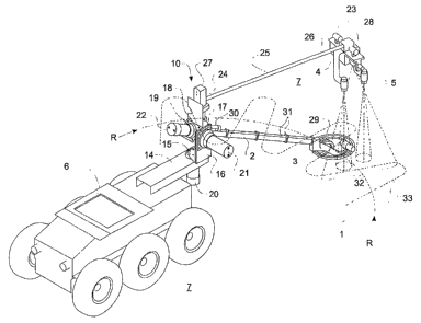
2 Having reference to Figs. 1 and 2, a robotic scanner 1 comprises
3 a detector supporting arm 2 with one or more mine detectors (a metal
detector
4 3 shown), and one or more range-finding sensors (two types shown, a laser 4
and ultrasonic 5), all mounted to a wheeled vehicle 6 which traverses the
6 ground 7.
7 The vehicle 6 comprises a small chassis supported on wheels
8 having onboard data communication and other electronics, a computer and a
9 power system (details not shown).
The detector arm 2 utilizes a slender nonmetallic member
11 connected at one proximal end 8 to the vehicle 6. The mine detector 3 is
12 connected and supported at the other distal end 9 of the detector arm 2.
The
13 defector arm 2 is manipulated in three dimensions using a multiple degrees
of
14 freedom (DOF) joint 10 for optimal positioning of the detector 3 precisely
with
respect to the ground 7 ahead of the vehicle 6.
16 In its simplest configuration and having reference #o the kinematic
17 model of Fig. 4, the proximal end 8 of the detector arm 2 is fitted with
the multi-
18 DOF joint 10 including a turret 11 having rotational axis z0 for permitting
left
19 and right panning arm 2 action, and a shoulder 12 having a rotational axis
z1
for tilting the arm 2 up-and-down. A roll axis 13 for rotation about the z2
axis of
21 the detector arm 2 is optionally provided for improving the tracking of
22 undulating terrain 7. The multi-DOF joint 10 is a spherical joint having a
23 common 3-axis joint center. This spherical configuration simplifies the
7
CA 02339924 2001-02-05
WO 00/54076 PCT/CA00/00235
1 geometric analysis including the kinematic model and the Jacobian Matrix
used
2 to define the detector arm 2.
3 The joint 10 is physically mounted on the vehicle 6 as follows: a
4 cantilevered support 14 extending horizontally forwards from the vehicle 6
and
having a pan pivot 15 located at its distal end; a bracket 16 extending
vertically
6 from the pan pivot 15 and having a tilt pivot 17 at its upper end; a
horizontal
7 bracket 18 extending horizontally from the tilt pivot 17 and having a roll
pivot 19
8 located therein. The z0, z1, z2 axes of the pan, tilt and roll pivots
15,17;19 all
9 coincide (spherical).
Integrated motor and gearbox actuators 20,21,22 are fitted to
11 each of the three pivots: a pan motor 20 mounted to the cantilevered
support
12 14 to actuate arm 2 panning; a tilt motor 21 mounted to the vertical
bracket 16
13 to actuate tilt; and a roll motor 22 mounted to the horizontal bracket 18
to
14 actuate roll.
The mine detector 3 is panned side-to-side at the end of the arm
16 2 along an arcuate path R. In one simple mode, the detector 3 is advanced
by
17 advancing the vehicle 6. Accuracy can be maximized and vehicle vibration
18 interference can be minimized by optionally extending the length detector
arm
19 between vehicle moves.
The mine detector 3 can be one or more detectors including
21 ground penetrating radar (GPR) or metal detectors. In a simple application,
a
22 metal detector is used, available as a model F1A6 metal detector from
MineLab
23 Electronics Pty, Ltd., Australia, having a digital output. A mine detector
for
24 metallic objects is obviously influenced by metal and thus non-metallic
structure
8
CA 02339924 2001-02-05
WO 00/54076 PCT/CA00/00235
1 is used to connect the metal detector 3 to the arm 2 and further, the
detector 3
2 is physically spaced from the metal-bearing vehicle 6 by the non-metallic
3 detector arm 2. Detection of a possible mine is detected as a signal
exceeding
4 a pre-determined threshold and the object can be electronically flagged as a
possible mine.
6 The range-finding sensors 4,5 comprise a downward-directed
7 laser-rangefinder ("laser") such as that available as the 5 mW laser, model
8 AccuRange 4000-LV laser range finder produced by Acuity Research, Inc.,
9 Menlo Park, CA. The 4000-LV has a visible beam for safety purposes. A laser
is a pin-point device and thus a rotating mirror (not detailed) is used to
enable
11 scanning of a line segment 32 when stationary (see Fig. 3a) or a sinusoidal
12 pattern 33 if moving laterally (see Fig. 2a). By combining tilting and
rolling the
73 mirror, it is possible to redirect the laser and obtain distance
measurements
14 from other directions without moving the laser in translation (three
dimensional
mapping).
16 Additionally, two downward-directed ultrasonic sensors 5 are
17 shown, used as backup for the laser 4 or as redundant sensors for increased
18 reliability. Despite remote operator location, safety issues still suggest
that at
19 least two sensors 4,5 should be provided to ensure distance data is
available.
Suitable ultrasonic sensors 5 are available such as model Sonarange SR3
21 manufactured by EMS Engineering and Manufacturing Services. Further, two
22 additional ultrasonic sensors 23 are provided which are directed laterally
for
23 detecting the presence and distance to side obstacles.
9
CA 02339924 2001-02-05
WO 00/54076 PCT/CA00/00235
1 While the geometry is simplified if the range-finding sensors are
2 mounted on the mine detector, special allowances must be made if a metal
3 detector is used as 'the mine detector 3. To minimize metallic interference,
as
4 the laser typically contains metal, it is separated from the mine detector
for
minimizing interference. The ultrasonic sensors 5 also typically have metal
6 transducers and the large energy pulse can interfere with the metal detector
3
7 thus they are best located with the laser and not mounted off of the metal
8 detector 3 itself.
9 Preferably the laser 5 is mounted and supported at the distal end
26 of a non-metallic rangefinder arm 25 (LRF arm) which is located above the
11 detector arm 2. The proximal end 24 of the LRF arm is mounted with a turret
12 27 to the roll bracket 18, above the spherical joint 10. The LRF turret 27
is
13 actuated with a motor which permits left and right panning action. A wrist
joint
14 28 is fitted at the LRF arms distal end 26 for tilting the LRF sensors 4,5.
The
axis of the wrist joint 28 is positioned vertically above the mine detector 3
which
16 simplifies the kinematic analysis including the Danavit-Hartenberg's 4 x 4
17 transformation matrices.
18 The LRF turret 27 and arm 25 are panned synchronously with the
19 panning of the detector arm 2.
The mine detector 3 is preferably connected to the detector arm 2
21 with a controllable joint 29 to adjust pitch. As in hand-held detectors,
this not
22 usually a dynamic variable, and typically it will have a preset
orientation. An
23 actuator 30 for driving joint 29 is usually associated again with metal.
24 Accordingly, a ,parallelogram linkage 31 is provided, actuated adjacent the
CA 02339924 2001-02-05
WO 00/54076 PCT/CA00/00235
1 proximal end 8 of the detector arm 2 with a small linear actuator 30, aided
2 further with non-metallic linkage 29 at the metal detector 3.
3 Combined control of the panning and tilting of the detector arm 2
4 is determined .from measurements of the spacing between the mine detector 3
and the ground 7. It is understood that ground 7 refers to the terrain in
general,
6 which can include objects on or below the ground's surface.
7 The three-dimensional position of the mine detector 3 is known in
8 a local-vehicle coordinate system; established from the measured relative
9 position of the pan, tilt and roll actuators at the spherical joint 10, and
the
geometry of the arm 2 and mine detector 3. Positional feedback instruments
11 such as optical encoders in the actuators provide the geometry of the
joint.
12 The spacing of the mine detector 3 and the ground 7 is
13 determined using the LRF sensors 4,5. The LRF sensors are directed
14 downwardly to provide substantially instantaneous measurement of their
distance from the ground 7. This sensor 4,5 distance information is
established
16 in the local-vehicle coordinate system and processed with the known
position of
17 the mine detector 3, also known in the local-vehicle coordinate system.
18 Adjustment of the relative spacing of the mine detector 3 and the
19 ground 7 is performed in real time. The LRF sensors 4,5 determine the
location of ground 79 compare that with the known position of the mine
detector
21 3 and its positioned is adjusted accordingly.
22 In operation, the mine detector is moved cyclically in a left and
23 right, back and forth panning or sweeping action across a scanned region R.
11
CA 02339924 2001-02-05
WO 00154076 PCT/CA00/00235
1 Thus, one lateral side of the mine detector 3 alternates between being a
2 leading and trailing edge.
3 The embedded controller can provide autonomous operation of
4 the panning function wherein back-and-forth panning and incremental vehicle
advance is automatic. The vehicle advance can be automatic or human
6 directed.
7 The terrain 7 which is ahead of the mine detector 3 must be
8 determined or mapped before the mine detector passes over it. In its
simplest
9 form, mapping the terrain involves determining the grounds relative
elevation
along a two-dimensional scanning line segment 32 ahead of the mine detector
11 3, the line 32 extending at least the projected width of the mine detector
3.
12 The LRF sensors 4,5 are arranged for sensing the ground 7
13 ahead of the moving mine detector 3. When the mine detector moves left, the
14 LRF sensors map the terrain to the left, ahead of the moving sensor. When
the
mine detector moves right, the LRF sensors map the terrain to the right, ahead
16 of the moving sensor. Accordingly, alternate location mapping requirement
is
17 preferably implemented by panning the LRF arm 25 so as to position the LRF
18 sensors 4,5 ahead of the mine detector 3 regardless their position in the
mine-
19 sweeping cycle.
The LRF sensors 4,5 are expensive and economics favor using
21 one set of LRF sensors 4,5 and moving or directing them ahead of the mine
22 detector 3.
23 Simply then, in one embodiment, before the mine detector moves
24 to the left, the LRF arm 25 is panned left to a position ahead of the
intended
12
CA 02339924 2001-02-05
WO 00154076 PCT/CA00/00235
1 mine detector movement. Then, when the detector arm 2 pans, the LRF arm 25
2 also pans. The LRF sensors 4,5 remain sufficiently in advance of the mine
3 detector 3so that the terrain 7 can be measured and the geometry processed
4 before the mine detector 3 transverses the measured terrain. Before the mine
detector 3 cycles back to the right, the LRF arm is panned right to be
6 repositioned again ahead of the detector 3.
7 The operation of the present invention is best illustrated . in the
8 form of an actual test example.
9
Example
11 A tele-operated vehicle, model MR-1 from Engineering Services,
12 inc., Toronto, Ontario was used as the vehicle 6. This vehicle is a
commercial
13 form of an explosives robotic vehicle. The vehicle comprised a chassis
having
14 six tow ground pressure tires and a control box. Data communications and
control cable extended between the vehicle and a remote operator control (not
16 shown). The MR-1 had an embedded onboard computer and the operator
17 control had a linked host computer. The embedded computer performed the
18 vehicle motion analysis, sensor data analysis and fusion, and mine detector
79 position and trajectory tracking. The techniques for implementing kinematic
analysis for determining relative positioning, sensor data fusion and tele-
21 operation of robotic vehicles has been applied in the context of mine
detection
22 by those skilled in the art. Neither the kinematic analysis, the principles
of
23 sensor fusion or remote operation is discussed herein in any great detail.
13
CA 02339924 2001-02-05
WO 00/54076 PCT/CA00/00235
1 An articulated plastic detector arm 2 and a laterally-pivotable
2 plastic LRF arm 25 were mounted to the front of the MR-1 vehicle 6. The
3 detector arm 2 used three separate actuator motors 20,21,22 at its proximal
4 end 8 for implementing arm pan, tilt and roll. Arm roll and mine detector
pitch
control were not implemented in this example. The LRF arm 25 used an
6 actuator 27 at its proximal end 24 for panning functions.
7 The actuators 20,21,22 and 27 comprised a DC motor with
8 integrated gears and optical positional feedback encoders (not detailed).
9 Harmonic gearboxes minimized backlash, provided high torque and used a
concentric inputloutput shaft design.
11 The objectives for the panning speed for the mine detector 3 were
12 set at 1.4 m/s. Accordingly, the pan motor 20 had to produce angular rates
of 1
13 radls or 12 rpm at the motor 20. Acceleration requirements were about 5
14 radlsec2. The total inertial load was about 5 kg at 1.4 m, or about 10 kgmz
for a
maximum moment load at the pan pivot of 50 Nm. A suitable motor was a
16 model RFS-20-3012 available from HD Systems Inc. of Hauppauge, NY.
17 Similar design criteria were applied to spec the tile, roll and LRF pan
actuators.
18 Acceleration of the both detector arm 2 and LRF arm 25 were
19 managed using a trapezoidal acceleration curve: linear acceleration;
constant
velocity; and linear deceleration.
21 A MineLab F1A6 metal detector 3 was used. The LRF arm 25
22 supported five sensors: two downward-directed Sonarange SR3 ultrasonic
23 sensors 5 for distance measurement; two laterally-directed ultrasonic
sensors
24 23 for obstacle distance determination and an AccuRange 4000-LV laser 4.
14
CA 02339924 2001-02-05
WO 00154076 PCTICAOOI00235
1 The laser 4 itself uti9ized its integrated rotating mirror to provide LRF
tilt rather
2 than a separate joint 28.
3 The AccuRange 4000-LV laser 4 most closely matched the
4 desired design characteristics being: a sampling frequency of about 100 -
1000
per second, resolution and accuracy of about 2.5 mm, a focused beam pattern
6 of about 3-5 mm diameter, a range of 0 - 2 m and have minima! metal content
7 so as to coexist with metal detectors.
8 Practically, the combination of the design parameters resulted in
9 a mine detector 3 which could be panned back and forth while being
automatically raised and lowered to follow the terrain 7 so as to maintain a 5
11 cm spacing.
12 A series of indoor and outdoor tests were performed. All test
13 used basically the same procedure. The vehicle 6 was positioned onsite. The
14 arms 2,25 were released from a parked position. The computing system and
actuators were initialized and the articulated arm joints 15,17,19 were zeroed
or
16 "homed-in". Pan actuator 20 drove the detector arm to a ready position,
17 orthogonal to the front of the vehicle fi. The tilt actuator adjusted the
mine
18 detector 3 to within 10 cm of the ground 7.
19 Referring to Figs. 4 and 5, scanning was commenced. The pan
actuator 20 adjusted the turret angle q1 so as to move the detector arm 2 to
its
21 range of travel on one side (See Fig. 5 for a left side start) with the LFR
arm 25
22 turret angle q5 adjusted to lead the detector arm 2 by about 15°.
The turret
23 shoulder angle q2 was adjusted to space the center of the mine detector 5
cm
24 above the ground.
CA 02339924 2001-02-05
WO 00/54076 PCT/CA00/00235
1 As shown in Fig. 5, the range of panning travel exceeds the width
2 of the vehicle 6 so as to ensure a mine-free advance path.
3 Cyclical and continuous panning of q1 and q5 was commenced.
4 After panning each scanned region R, the vehicle fi was advanced to the next
scanning region R', R".
6 The laser 4 had a 2600 rpm rotating balanced mirror. The mirror
7 and its optical position encoder were only operated only in one dimension
for
8 the example so that only a scanned line segment 32 of terrain 7 was obtained
9 ahead of the mine detector 3. The mirror speed produced a 30 cm scanned
fine and at the panning speed of 1.4 mls, the scanned line segment 32 resulted
11 in a sinusoidal pattern 33 which repeated welt before the maximum permitted
12 advance of 15 cm of the detector 3.
13 The laser 4 determined its own distance to the ground 7. The
14 ultrasonic sensors 5 also established their own respective distances to the
ground 7.
16 The three LRF sensors' 4,5 distance data was filtered and a
17 sensor fusion process was used to obtain the distance to the ground 7. The
18 ultrasonic sensors 5 were also used to calculated terrain pitch. All three
19 sensors 4,5 were averaged to calculated distance to the ground 7. Filtering
was performed to deal with sensor error in reading challenging terrain
surfaces
21 and noise generally. Data for each sensor 4,5 was over-sampled and a
22 number of high and low samples were rejected. The remaining data was
23 averaged. Each sensors average data was subjected to a first-order low-pass
24 filer having a bandwidth at 50 H~ for canceling certain noise. Lastly,
pairs of
16
CA 02339924 2001-02-05
WO 00/54076 PCT/CA00/00235
1 the three filtered sensor readings were compared according to a pre-
2 determined threshold. If all pair comparisons were similar, an average of
all
3 three readings was taken. If only two compared then an average of the two
4 similar readings was taken. If none are similar then the previous calculated
value was taken.
6 The optical encoders in the two pan and tilt actuators 20,21,22
7 provided positional data used in the data fusion process.
8 Using the data obtained and the kinematic relationships of the
9 arms 2,25, detector 3 and sensors 4,5, terrain parameters were calculated
including ground elevation, pitch angle and roll angle.
11 The terrain parameters or data was stored periodically according
12 to a sampling period. The data was stored in a table with a time offset for
13 delayed use when the position of the leading edge of the panning mine
detector
14 3 corresponded to the position the terrain parameters were obtained.
At the end of each cycle, data acquisition was interrupted only
16 long enough for the LRF arm 25 to reset and move to the leading side of the
17 mine detector 3. The terrain data missed during the resetting of the LRF
arm
18 25 for the cycle was interpolated from the termination of the last cycle.
19 As the desired position of the center of the metal detector 3 was
set (spaced 5 cm above the ground 7, orthogonal to the terrain), then the
21 inverse kinematic problem could be solved to obtain the necessary angles
for
22 pivots 17, 19 29 to achieve the 5 cm spacing. More particularly, for the
known
23 the angles were determined for the shoulder tilt q2, wrist roll q3 and
wrist pitch
24 q4.
17
CA 02339924 2001-02-05
WO 00/54076 PCT/CAOO/OU235
1 The embedded controller output the necessary angles to the
2 respective pan, and tilt motors for positioning the detector arm 2 and mine
3 detector 3.
4 Indoors, the test terrain 7 included artificial and natural objects of
varying complexity, which included cardboard, wooden surfaces, and pieces of
6 sod. Terrain profiles included flat through smoothly varying, gently
undulating
7 and abrupt.
8 Outdoors, the terrain 7 included gravel and dirt road surfaces,
9 natural prairie having grass up to 15 cm in height, 15 cm high by 30 cm
diameter mounds of dirt and a mud puddle. Additional factors included those
11 affecting the laser 4 such as bright sun and reflective surfaces.
12 The ultrasonic sensors 5 detected distances reliably in within 10°
13 of normal from shiny surfaces and within 25° of rough surfaces. At
distances of
14 8 - 40 cm, the resolution was within 1.5 mm. Ripples on water reduced
reliability. The sensors' cone angle was 7:2°, having a range of 20 -
91 cm and
16 a sound frequency of 200 Hz. Ultrasonic pulse firing frequency was over 100
17 Hz to ensure that, at 1.4 mls panning speed, samples are obtained at least
18 every 14 mm. As the test used a metal detector 3, the metal content of the
19 ultrasonic sensors was minimized, using aluminum or in this case PVC
housings.
21 For example, as illustrated in Fig. 6, one of the many tests
22 performed included an outdoor panning mine sweep which included flat
ground,
23 a mound and immediately into a puddle filled depression and flat ground
again.
18
CA 02339924 2001-02-05
WO 00/54076 PCT/CA00100235
1 As a result, the mine detector 3 was found to satisfactorily
2 negotiate most objects other than abrupt transitions. It is anticipated that
3 enhanced laser operation to include the three dimensional mapping rather
than
4 merely the scanned Hine segment 32 will overcome step changes.
The technique of advancing the vehicle 6 so as to advance the
6 arms 2,25 and mine detector 3 to the next scanning region was crude and more
7 precise arm-extension control should be implemented. The reflective surface
of
8 the puddle resulted in variable results including a false reading resulting
in a
9 chance contact of the detector 3 with the puddle.
Additional designs and options can be applied to the present
91 invention which include:
12 ~ improved function of the detector arm such as providing an
13 axial extension capability to permit the mine detector to be
14 moved a short distance along the line of advance without
moving the vehicle; and implementation of the wrist pitch joint
16 at mine detector for dynamically adjusting the mine detector
17 pitch angle to smoothly avoid terrain which changes along the
line of advance;
implementation of the side-looking sensors for detection and
avoidance of side obstacles; and use of video and radar
21 range-finders; and enhanced function of the LRF wherein the
22 . scanning mirror can be manipulated laterally so as to improve
23 the scanned line mapping to a full three dimensional mapping
19
CA 02339924 2001-02-05
WO 00/54076 PCT/CA00/00235
1 ahead of the mine detector far better anticipating sharp
2 changes in terrain and controlling wrist roH maneuvers; and
3 ~ provision of inertiai navigation systems or differential global
4 positioning systems for enabling recordation or mapping of the
detected abject in a ground-based coordinate system for
6 subsequent placement of a trailing confirmatory sensor, a
7 mark or merely for re-location and mine neutralization.