Note: Descriptions are shown in the official language in which they were submitted.
CA 02342765 2004-11-12
VERTICAL SEISMIC PROFILING IN A DRILLING TOOL
BACKGROUND OF THE INVENTION
In drilling a borehole to recover oil from the earth, it is often helpful to
turn or steer the downhole drill bit toward or away from subterranean
targets. To facilitate this geophysical steering, drillers need to know drill
bit
location on the surface seismic section. The location of targets ahead of the
bit is also required, as well as some warning or indication of drilling
hazards
such as over-pressured formations or thin, shallow gas intervals. Surface
seismic surveys generally include this information, but resolution and depth
location is poor because surface seismic surveys are time based (rather than
depth based). For example, to determine the depth of a reflection, a speed
of sound for the formation must be known. Consequently, these systems
require depth calibration to accurately determine locations of target horizons
or drilling hazards. Traditionally, this calibration has been provided by
either
offset well sonic data or wireline checkshot data in the current well. Offset
data is often inadequate however due to horizontal variations in stratigraphy
between wells. Wireline checkshots require tripping (i.e., removing) the bit
out of the hole and are often prohibitively expensive.
During surface seismic surveys, a plurality of seismic sources and
seismic receivers are placed on the surface of the earth. The seismic sources
are triggered in a predetermined sequence, resulting in the generation of
seismic waves. These seismic waves travel downward through the earth until
reflected off some underground object or change in rock formation. The
reflected seismic waves then travel upward and are detected at the seismic
receivers on the surface. One or more clocks at the surface measure the
time from generation of the seismic waves at each source to the reception of
the seismic waves at each receiver. This gives an indication of the depth of
the detected object underground. However, the exact speed of sound for
these seismic waves is unknown, and thus, the exact depth of the detected
object is also unknown. To more closely measure the exact speed of sound,
a "wireline checkshot" may be used to calibrate depth measurements. During
a "wireline checkshot," a receiver on a "wireline" is lowered a known
distance into an already-drilled borehole. A surface seismic source is then
triggered and the time is measured for the seismic wave to travel to the
wireline receiver. Because the depth of the wireline receiver is known, an
average interval velocity indicating the average speed of the seismic wave
CA 02342765 2004-11-12
2
can be determined with some degree of accuracy.
Attempts have been made to provide "reverse vertical seismic
profiling" while drilling. This approach transposes the downhole location of
the receiver with the surface location of the seismic source. These attempts
have been based mainly on using the drill bit as a source of a seismic wave,
with an array of suitable receivers spread on the surface. These methods,
however, work with only specific bit types, and they will not work in highly
deviated wells. Also, attempts have been made to generate sources
downhole that permit reverse vertical seismic profiling. A source by
Klaveness, U.S. Patent No. 5,438,170 is akin to a drilling jar and generates
large tool modes and tube waves and poor seismic signals. Another known
source vibrates the bit with a piezoelectric. It has a very short range and
can
only be used with downhole receivers. Another drawback is that for
formations directly ahead of the bit, downhole sources and receivers cannot
distinguish between high-pressure formations and other reflective
boundaries. An air gun has also been placed downhole, but requires air lines
from the surface. Air guns and water guns are not ideal downhole sources
because they are localized sources that create large tube waves, require
intrusive pressure systems, and may damage the formation.
SUMMARY OF THE INVENTION
A vertical seismic profiling tool while drilling includes an appropriate
source positioned on the surface, and receivers located on a drill string.
Surveys may be taken with the drill bit stopped, either when making drill
pipe connections or whenever required. Checkshot readings may be made
and transmitted through the mud pulse telemetry system to facilitate real
time update of the bit position on the seismic section. In addition, distance
to and acoustic characteristics of reflectors ahead of the bit may be
determined and transmitted via the same mud pulse system. This would
enable target location and hazard detection ahead of the bit.
Thus, the present invention comprises a combination of features and
advantages which enable it to overcome various problems of prior devices.
The various characteristics described above, as well as other features, will
be
readily apparent to those skilled in the art upon reading the following
detailed description of the preferred embodiments of the invention, and by
referring to the accompanying drawings.
CA 02342765 2001-03-O1
WO 00/13043 PCT/US99/20246
3
BRIEF DESCRIPTION OF THE DRAWINGS
For a more detailed description of the preferred embodiment of the present
invention,
reference will now be made to the accompanying drawings, wherein:
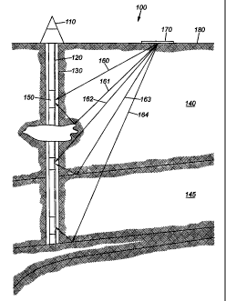
Figure 1 is a cut-away view of an embodiment of the invention.
S Figure 2 is a coarse interval transit time log for the well.
Figure 3 is a wireline vertical seismic profiling log from the well. The
surface air gun was a
single 150 cubic inch gun in a 9" deep pit. The wavefomls are total raw wave-
trains, up-going and
down going combined.
Figure 4 is LWD vertical seismic profiling data taken with a research LWD tool
over the
same interval as the wireline tool. The polarity is inverted from the wireline
tool, but the first
arnval detection is clear.
Figure 5 is the up-going wave-train for the wireline data set. Standard
processing was
performed to separate up and down going wave-fronts. Several reflectors are
clearly evident in the
data.
Figure 6 is the up-going wave-train for the LWD tool. Strong reflections at
1900,1800 and
1600 feet are apparent in the data, and this agrees with the velocity profile.
Figure 7 is a synthetic vertical seismic profiling, at different time scale
and depth
orientation, provided for comparison. This computed data set was based on
ideal Ricker wavelet
source function rather than the relatively "ringy" data set of our
experimental test, but is useful for
identifying reflections at 1900,1800 and 1600 feet.
Figure 8 is a graph showing a received seismic waveform corresponding to three
consecutive levels.
DETAILED DESCRIPTION OF THE PREFERRED EMBODIMENT
Refernng now to Figure 1, a system 100 according to the present invention may
include a
dernck 110 with an attached drillstring 120. A drill bit creates a well bore
130 through the
surrounding formation 140, which may also include formation boundaries
corresponding to, for
example, an over-pressurized zone 145. A sonic tool 150 with appropriate
seismic receivers is
attached to drillstring 120 and receives seismic signals 160 from a seismic
source 170, such as an
air gun array located on the surface 180. The use of an air gun array is
exemplary only, as the
system may be either land or marine-based, and is not seismic source-type
specific. For example,
the system may include a standard surface air gun array, either hung from an
offshore platform or
located on a service boat or anchored buoy. Control of this array is achieved
with standard
controllers. The array thus provides a suitable vertical seismic profiling
quality source. In a
CA 02342765 2001-03-O1
WO 00/13043 PCT/US99/20246
4
deviated well, the source would be appropriately offset from the rig; for
vertical holes, the source
could be located on and controlled from the rig. A clock to maintain accurate
timing is also uphole.
The downhole section of the system may include a combination of hydrophones
and
geophones in an auxiliary sub to a sonic tool. The geophone is a 3-axis type.
A highly stable real
time clock circuit is also included to provide time stamps for the checkshot
signals, along with
memory and control electronics. A modified sonic tool is appropriate to house
the pertinent
equipment. Signal conditioners and data modem are in the auxiliary sub. The
sub is properly
keyed to the bottom hole assembly so that directional data is available when
the sub fires. In other
words, the standard directional survey also provides orientation information
for the 3-axis
geophone. Optionally included with the sub is a tandem stabilizer that can be
installed to improve
tool coupling in near vertical wells. If desired, several detector subs can be
scattered throughout the
bottomhole assembly and controlled by the sonic tool. This facilitates better
detection and
resolution of signals of interest, such as direct waves from the surface and
reflections.
The preferred embodiment includes a "check shot" determination to establish
the average
interval velocity from the surface to the downhole receiver array. During this
determination, mud
flow stops, and the receivers on the drill string go into a listen mode.
Whether the mud flow is on
or off can be determined by a variety of standard means. A surface seismic
source is then triggered,
which generates a seismic signal having a frequency on the order of SOHz. The
seismic signal
generated by the surface source is thereafter detected at the downhole
receiver array on the drill
string. One advantage of the array of downhole receivers is that the downhole
components are
passive; unlike reverse vertical seismic profiling, there is no possibility of
borehole damage due to
powerful downhole sources.
If the seismic signal arnves during a predetermined clock interval, it will be
processed for
first arrival (check shot) information downhole. This typically involves the
measurement of the
"first break" on the received seismic waveform. The downhole electronics
record the time the first
break occurred for this received seismic wave based upon the downhole clock.
This is also known
as providing a "time stamp" for the received signal. The time stamp associated
with the first break
of the seismic checkshot signal is then transmitted to the surface via any
suitable transmission
means, typically a mud pulse system. In this way, checkshot information
arrives at the surface
while the drillstring is in the wellbore, avoiding a need to remove the
drillstring to measure the
interval transit time of a seismic wave. It is envisioned that a checkshot
reading would be taken
every 500-1000 feet, although this is not crucial to the invention.
The system at the surface calculates the total travel time from the surface
source by
monitoring the precise time that the source fired via a suitable trigger
detection system and
CA 02342765 2001-03-O1
WO 00/13043 PCT/US99/20246
comparing it to the checkshot data. The true vertical depth is corrected for
and the interval transit
time (i.e. total one way seismic travel time) is then available. Consequently,
the real time checkshot
values allow the bit position on the seismic section to be updated as drilling
progresses.
One difficulty with such an approach, however, is the time drift of the
downhole clock. Of
5 course, to make meaningful a time-of flight measurement of a seismic wave
from a surface source
to a downhole receiver, the measurement must be accurate. Thus, the downhole
clock should be
synchronized with the uphole clock to maintain accurate timing. However, a
drill bit may be in the
borehole for four or five days, with the clock drift on a crystal-based clock
being on the order of
plus or minus 30 milliseconds per day. When accuracy of within a millisecond
is desired, this
amount of clock drift is wholly unacceptable. Although methods currently exist
to reduce clock
drift, such as refrigeration of the clock, these techniques are very expensive
and often still are
subject to clock drift due to vibration from the downhole drilling. Further,
synchronization of
clocks at a receiver is either unnecessary (such as when a cable connects the
source and receiver) or
not feasible for the downhole receiver (such as radio or satellites).
Therefore, the invention preferably includes a method to synchronize the
downhole clock
with a surface based clock without tripping or removing the drill string from
the borehole.
Preferably, this synchronization involves transmitting a synchronization
signal through the drill
string or the casing. The travel time along the drill string or casing to the
downhole clock will also
be known, based upon the known depth of the clock and the known travel speed
through a drill
string or casing. Thus, a suitable generation time for the synchronization
signal can be selected.
For example, a synchronization signal may be generated by a piezo-electric
stack or a magneto-
strictive device on the surface at a predetermined time. To prevent undue
noise, the actual drilling
may be paused while the synchronization signal is sent downhole. This
synchronization signal can
then be detected and processed downhole and used to correct for any clock
drift of the downhole
clock. As an additional advantage, such an approach would allow the use of a
less expensive clock.
This system may also advantageously be used to improve a technique called
vertical seismic
proftling. In addition, the system can be used to avoid or otherwise take
precautionary measures
with respect to drilling hazards ahead of the bit. For example, high
resolution and an accurately
known depth to drilling hazards allows mud weight modification.
Refernng again to Figure l, seismic sources 170 on the surface are suitable to
generate
seismic waves 160-164. These seismic waves travel not only directly to the
receivers in the sonic
i 50, but also reflect off targets, transitions. or objects in tiont of the
drill bit. The reflected waves
then may travel to the seismic receivers contained in the sonic tool to
provide additional
information about the underground rock formation in front of the drill bit.
CA 02342765 2001-03-O1
WO 00/13043 PCT/US99/20246
6
To determine the character of the rock formation in front of the bit, the
surface seismic
sources are fired approximately every 50 feet of travel by the drill bit.
Consequently, the downhole
seismic receivers also detect reflected subterranean seismic waves every 50
feet of travel by the drill
bit.
An advantage to the embodiment of Figure 1 is the position of the receivers in
the CLSS,
which facilitates distinction between up-going and down-going wave trains.
Once the up-going
wave-train is obtained, a transfer function for the system ahead of the bit
can be effectively
determined. To obtain the transfer function for the system ahead of the bit,
the down going wave-
train is deconvolved with the total up-going wave-train. The distance to the
nearest reflector and
the relative acoustic impedance of that reflector can be extracted from the up-
going train with the
down going train as the input.
Figure 8 illustrates a series of waveforms that a receiver on a drill string
may detect after
consecutive shots by a surface seismic source. A first waveform corresponding
to wellbore depth
"a" includes a first check shot portion 810 and a first reflected portion 815.
A second waveform
corresponding to wellbore depth "b" includes a second check shot portion 820
and a second
reflected portion 825. Second check shot portion 820 is later in time than
first check shot portion
810, while second reflected portion 825 is earlier in time than first
reflected portion 815. A third
waveform corresponding to wellbore depth "c" includes a third check shot
portion 830 and a third
reflected portion 835. Third check shot portion 830 is later in time than
second check shot portion
820, while third reflected portion 835 is earlier in time than third reflected
portion 835. As the drill
bit moves further away from the surface seismic source and closer to the
target from which portions
815, 825, 835 have reflected, the check shot portion occurs later in time and
the reflected portion is
received relatively earlier in time. In particular, how closely these changes
in reception times are to
a linear progression can be used to indicate the relative location of the
underground target with
respect to the drill bit.
One hurdle to determining the distance to various targets underground based on
the
measured time differences is correlating the time differences to a specific
distance to a target. That
is, even with the advantages explained above, the exact location of hazards
and reflectors in front of
the drill bit is nonetheless difficult to determine because it must be based
on an inaccurate speed of
sound measurement. While the times of checkshot generation and reception can
yield a speed of
sound measurement over the total distance between a surface seismic source and
receiver on the
drill string, this measurement is subject to error from clock drift as well as
checkshot travel through
a formation or series of formations that have different speeds of sound than
the formation in front of
the bit.
CA 02342765 2001-03-O1
WO 00/13043 PCT/US99/20246
7
A solution to this difficulty is use of a sonic tool together with the
receiver array on the
drillstring. The sonic tool downhole may be used to measure the local interval
transit time and,
hence, the speed of sound for the formation close to the bit. So although the
sonic tool
measurement of the interval transit time near the drill bit may not be
particularly suited for the long
distances involved in a checkshot measurement, it is very well suited for
determining the distance
to a target in front of the bit. Thus, use of a sonic tool in combination with
seismic receivers on the
drill string provides for a higher resolution measurement of targets ahead of
the drill bit. Further,
the measurement of the sonic tool is not subject to error because of clock
drift.
Data obtained by the sonic tool can also be used to improve further the
vertical seismic
profiling. For example, the measurement of the formation surrounding the
borehole at varying
depths by an acoustic tool provides an indication of the depths at which the
formation changes. To
make an even more accurate determination of the depth at which formation
changes occur, the
transmission on the casing or drillstring that synchronizes the downhole clock
may also indicate
that the sonic tool has traveled a predetermined distance, such as 50 or 100
feet. The accurate
measurement of changes in the formation's speed of sound by an acoustic tool,
and the accurately
known depth at which these changes occur, improves the results of vertical
seismic profiling.
Further, this will provide highly accurate casing and coring point
determination. If a density tool is
further run in combination. acoustic impedance can be measured directly.
Thus, checkshot data and wellbore sonic data from the sonic tool, and density
data, can also
be combined to yield optimal synthetic seismograms. These synthetic
seismograms may be
compared with the surface seismic plots to improve the accuracy, and ensure
the quality, of the
surface seismic plots. The accuracy of this system allows a sample seismic
wavelet to be
convolved with data regarding the exact depth of formation changes to yield an
example wave-
train. In particular, the sample seismic wavelet is convolved with data
regarding the reflection
coefficients at each underground boundary, based on Snell's law. This
generates a synthetic surface
seismogram with an accurate reflection pattern that is unavailable in any
other way. However, the
synthetic surface seismogram contains errors, for example because of the
difference in a sonic
frequency as contrasted to a seismic frequency. This results in a depth error
of about 1-2%. Such
errors in the synthetic seismogram pertaining to depth can be corrected for by
the checkshot data.
Thus, the synthetic wave-train may be processed with the measured wave-trains
to obtain a wave-
train that includes only first reflections. Such a wave-train would accurately
indicate the location of
downhole hazards and formation changes of interest.
Consequently, in addition to transmitting checkshot data to the surface, a
representation of
the entire received waveform including the portion after the first break may
be stored in memory
...~,. ,~. ~:~ M
CA 02342765 2001-03-O1
WO 00/13043 PCT/US99/20246
8
downhole, in either a compressed or uncompressed format. Alternately, this
information may be
sent uphole while drilling if sufFcient data communication rates to the
surface can be achieved.
Figures 2-7 are experimental results of the present invention. The data were
from a series of
tests with an actual research prototype made in the HES test well in Fort
Worth, Texas.
While preferred embodiments of this invention have been shown and described,
modifications thereof can be made by one skilled in the art without departing
from the spirit or
teaching of this invention. For example, the system can be expanded through
the addition of a
downhole source to provide signal well imaging while drilling. Other data
interpretation techniques
used in conjunction with wireline, such as accounting for data migration
during seismic surveys,
may also be adapted for use with the invention. The embodiments described
herein are exemplary
only and are not limiting. Many variations and modifications of the system and
apparatus are
possible and are within the scope of the invention. Accordingly, the scope of
protection is not
limited to the embodiments described herein, but is only limited by the claims
that follow, the scope
of which shall include all equivalents of the subject matter of the claims.