Note: Descriptions are shown in the official language in which they were submitted.
CA 02351683 2001-05-16
WO 00/30384 PCT/SE99/01746
METHOD AND ARRAN6ENIENT FOR MEASURIN6 AND PREDICTING OF RADIO CONDITIONS IN
A COMMUNICATIONS SYSTEM
FIELD OF INVENTION
The present invention relates to a method and devices for
wireless communication with a mobile station.
DESCRIPTION OF RELATED ART
In a mobile telecommunication system the transmission quality
is dependent on a wide range of radio conditions. The radio
conditions vary with the distance from the base station,
atmospheric conditions, the topography around the considered
mobile station etc. As the radio conditions are rapidly
varying for the considered mobile station, the transmission
quality may sometimes deteriorate in such an extent that the
connection is lost. On the other hand, when the radio
conditions are good, the transmission quality may be
oversized resulting in unnecessary costs. However, the
problem associated with extracting a useful estimation of the
radio environment of a mobile station in communication in
order to predict how the radio conditions will change in the
near future for a considered mobile station remains unsolved.
Having no information on the location of the mobile station
in comKnunication it is very hard to predict how the radio
conditions will change in a near future for a considered
mobile station. The radio network algorithms for a radio
communication system are usually designed to try to follow
the changes of the radio conditions and react upon the
changes in order to suitably adapt electric and other
CA 02351683 2001-05-16
WO'90130384 PCT/SE99/01746
2
characteristics when transmitting to a mobile station.
However the radio environment of a mobile station is mostly
changing very fast. For example, a small change in the
position of a mobile station may result in a large change in
received signal strength due to rapid fading. Therefore it is
also mostly very difficult to accurately and rapidly enough
follow the changing radio conditions. In order to improve the
transmission from the base station data associated with the
geographic position of the mobile station can be used. Thus,
in GB-2271486 a communication system is disclosed, wherein a
base station communicates with a number of mobile communi-
cation devices and is coupled to a central controller for
relaying messages to the controller and for receiving and
relaying control information from the controller. A number of
mobile stations are provided with a GPS (Global position
system) receiver in order to receive information from a GPS
relating each mobile communication device to a geographic
position (x, y, z). A transceiver transmits messages to the
base station and receives control information from the base
station. A transmitted message includes information relating
to the geographic position (x, y, z) and the controller
administers, through control of a base station, control of
the communication system in response to geographic position
information transmitted by the mobile communication devices.
In the patent application GB-2271486 a method for dividing
the coverage area into overlapping and non-overlapping areas
and assigning different channels depending on the position of
the mobile is disclosed. Signal strength decides the
partitioning of the area not using any filtering of the
position information. The deficiency is that said data are of
insufficient quality as said data are registered for each
measurement point.
CA 02351683 2001-05-16
WO 00/30384 PCT/SE99/01746
3
WO-9801768 discloses a facility to make timing measurements
between base stations and a mobile station in order to
indicate the distance of the mobile station from at least one
of the base stations. The distance indications in these
systems will often be processed to produce an ambiguous
indication of the position of the mobile station, and WO-
9810768 deals with resolving position ambiguities using
several techniques such as signal averaging, forming a signal
contour map, making Doppler measurements, obtaining traffic
flow information, and processing historical position data. In
a second aspect the combination of two or more of the
ambiguity resolution techniques can be achieved by multi-
sensor fusion, probabilistic approaches, nearest neighbour
and Kalman filter techniques that allow the integration of
multiple sources of information over time. The preferred
technique for integrating and evaluating the sequence of
timing measurements is using the Kalman filter combined with
probabilistic techniques to weight each of the measured
events. The most likely of the sequences is chosen as
indicating the true position of the mobile station. A spin-
off of the technique is the ability to automatically derive
signal strength contour maps. These maps can be used to
inmprove the hand-off performance of the cellular network and
for the purposes of network planning and design. The signal
strength maps are continually updated, and it is hence
possible to have them compensated for seasonal changes, such
as tree foliage, by changing multipath and signal occlusion
and this enables an automatic adaptation to any changes in
the mobile network configuration. A single signal strength
measurement may be susceptible to various fading influences,
and a method using a single signal strength may use various
signal averaging techniques to obtain a signal strength
CA 02351683 2001-05-16
WO 00/30384 PCT/SE99/01746
4
measure more indicative of the location of the mobile
station. A signal strength contour map may be generated, and
this map may also be used to resolve ambiguities. A system in which the method
described in WO-9801768 is carried out may
continuously integrate information from many sources to keep
the information up to date and to compensate for the time-of-
day, day to day and seasonal variations. The deficiency with
the solution described in WO-9801768 is that it only deals
with finding the exact location of the mobile station.
WO-9427398 discloses a method to determine the location of
a mobile station using GPS, LORAN (LOcation Radio Based
Navigation), triangulation or other position determining
systems. Information on the geographic location, shape and
size of each cell is stored in a look-up table. The
position of the mobile station is constantly updated, and
call management decisions, such as hand-off, can be made
based on the location of the mobile station. The MTSO
(Mobile Telecommunication Switching Office) has a look-up
table in its data storage facilities which is used for
comparing positional data from the mobile stations to data
associated with the cell site coverage areas. Based on a
look-up in this table, the MTSO can select the cell site,
which is the most appropriate to a call. The deficiency of
the disclosure of the application WO-9427398 is that the
data in the database is not regularly updated.
JP-06350516 discloses a method for determining positions of
mobile stations using the GPS. A receiver receives electro-
magnetic waves from a measuring object of the mobile sta-
tion. A statistical processor processes the amplitude of
the electromagnetic waves. A controller stores the statis-
CA 02351683 2001-05-16
WO 00/30384 PCT/SE99/01746
tically processed data, based on the position information
of the navigation system controller. The method according
to JP-06350516 is used to determine base stations in hand-
off. The data are only statically processed, and then time
5 is not considered, which is not satisfactory in order to
provide an accurate description of the radio conditions of
an area around the mobile station.
SIIMARY OF THE INVENTION
The methods disclosed in the cited documents GB-2271486, GB-
2313742, WO-9801768, WO-9427398, JP-06350516 deal with the
position of the mobile station. None of these cited documents
deals with processing incoming data related to mobile
stations in a radio telecommunication system in such a way
that it is possible to extract useful information concerning
the radio conditions around a considered mobile station.
The deficiency is that the information is not filtered using
coefficients considering area and time, and therefore the
information can not be used in algorithms, which may improve
the performance of the network. The term "filter" is herein
defined as the mathematical process by means of which the
data concerning the mobile station, its position, signal
quality, and other information, are processed over area and
time. The term "filtering" is herein defined as using the
filter by means of which the incoming data are processed. The
term "smoothing filter" is herein defined as a filter, which
smoothes data concerning the radio conditions, i.e.
decreasing variance of data. The term "active set" is herein
defined as the set of base stations, which communicate with a
considered mobile station.
CA 02351683 2001-05-16
WO 00/30384 PCT/SE99/01746
6
One object of the present invention is thus to process the
information concerning the location of the mobile station
by means of a filter in order to create a map of signal
quality versus location. This map may be used to more
accurately predict radio conditions in each zone and hence
change the performance of the radio network algorithms.
A further object of the invention is to determine if a base
station belongs to the active set, e.g. for soft hand-off in
a CDMA system or macro diversity in general.
Another object of the invention is to force a mobile station
to make hand-off earlier than scheduled due to some expected
change, for example before entering a tunnel, using said
processed information.
The present invention is intended to solve the problem
associated with controlling the transmission in communi-
cation with a mobile station using information on the
geographic position and the radio environment of the mobile
station. It is made by processing the information, e.g. by
means of a filter in order to smooth information, which is
generally measured for specific, localised geographic
positions, not for an area. This information is processed
to be valid for a region according to a probability
function. Then slowly varying position based information of
the radio conditions is obtained which can then be used to
enhance the performance of the existing radio network
algorithms. =
The present invention thus provides methods for processing
radio condition information related to the location of the
mobile station in order to improve existing radio network
CA 02351683 2001-05-16
WO 00/30384 PCT/SE99/01746
7
algorithms, e.g. algorithms for hand-off, cell selection or
creating dynamic cell sizes. The initial choice of
communication channel and output power could also be
improved by this location dependent information.
An advantage of the invention is that it enables, using said
processed information, the choice of a channel with a minimum
of interference.
An other advantage of the invention is that it enables, using
said processed information, the choice of power setting, in
order to optimise the use of energy, i.e. to use appropriate
amount of energy.
A further advantage of the invention is that it enables,
using said processed information, the choice of an
appropriate base station, e.g. the base station in a
hierarchical cell structure providing the best quality versus
power consumption.
The invention creates opportunities to enhance the
performance of existing radio network algorithms by
predicting the radio conditions within a specified area. It
also reduces the need for highly accurate position
measurements when applying the position related information
in network functions since the filtering over the area
smoothes the measurements made on several points in the
database.
The invention also creates possibilities to decrease the size
and identify the areas where certain events, such as dropped
calls or failed hand-offs, often occur. This could be used to
make it possible to start countermeasures against poor
CA 02351683 2008-03-26
8
planning or configuration of the communication system, e.g.
size and location of the cells.
In one aspect, the invention provides a radio
telecommunication system comprising at least one mobile
station, a database and at least one base station, said
radio telecommunication system comprising:
position determining means for determining a position of
the mobile station;
measuring means for measuring radio conditions in
communications between the base station and the mobile
station;
processing means connected to the position determining
means and the measuring means for mathematically processing
the measured radio conditions and the determined position
of the mobile station, and further analyzing data of radio
conditions and position information with respect to earlier
processed and stored data concerning radio conditions
related to positions of a mobile station in an area around
the determined position of the mobile station, said
processing means analyzing said data to classify and group
said data to create a map divided into zones, each zone
having an associated classification indicative of the radio
conditions in the zone, so that the radio conditions are
substantially uniform in each zone;
storing means connected to the processing means for
storing the processed data in the database; and
transmitting means, coupled to the at least one base
station, being arranged to control transmission to the
mobile station in accordance with data stored in the
database.
CA 02351683 2008-03-26
8a
In one aspect, the invention provides a method for
filtering data, collected from connections in a radio
telecommunication system, which includes a number of mobile
stations, and at least one base station, wherein radio
conditions are measured and the measured radio conditions
are related to a current reported position of a mobile
station, said method further comprising the steps of:
processing incoming data by a filter in such a way that
the information related to a mobile station and its
position is analyzed with respect to earlier collected and
processed data concerning an area of a predetermined size
around the mobile station;
classifying and grouping said data to create a map
divided into zones, to give each zone a classification,
which indicates the radio conditions in the zone, so that
the radio conditions are substantially uniform in each
zone; and
storing the classified data in a database.
In one aspect, the invention provides an apparatus for
filtering data, collected from connections in a radio
telecommunication system including a number of mobile
stations and at least one base station, said apparatus
comprising:
means for processing incoming data by a filter in such a
way that information related to a mobile station and its
position is.analyzed with respect to earlier collected data
concerning an area of a predetermined size around the
mobile station;
means for classifying and grouping said data together to
create a map divided into zones, to give each zone a
classification, which indicates radio conditions in the
CA 02351683 2008-03-26
8b
zone, wherein the radio conditions are substantially
uniform in each zone; and
means for storing said classified data in a database.
Further scope of applicability of the present invention
will become apparent from the detailed description given
hereinafter. However, it should be understood that the
detailed description and specific examples, while
indicating preferred embodiments of the invention, are
given by way of illustration only, since various changes
and modifications* within the spirit and scope of the
invention will become apparent to those skilled in the art
from this_detailed description.
BRIEF DESCRIPTION OF THE DRAWINGS
The invention will now be described in more detail by way
of example with reference to -preferred non-limiting
embodiments thereof and also with reference to the
accompanying drawings; wherein
Figure 1 is a flowchart illustration of the operational
steps of a system according to the invention.
Figure 2a, 2b illustrate components and processing steps
of a system for communication with a mobile
station.
CA 02351683 2001-05-16
WO 00/30384 PCT/SE99/01746
9
Figure 3 is a flow chart of the steps used in handling a
database according to the invention.
Figure 4 shows another embodiment of the invention.
Figure 5 shows yet another embodiment of the invention.
DESCRIPTION OF PREFERRED EMBODIMENTS
Fig. 1 shows a flow chart illustrating the functional steps
of one embodiment of the invention.
in a first block 10, data concerning the position of a
considered mobile station are collected, for example by means
of triangulation or GPS, events such as lost connection or
hand-off failure at the registered position and signal
quality, signal strength and the time when said events
occurred. In the case of a lost connection, the information
concerning the position of the mobile station may be
collected at the time when the connection is lost. In the
next block 25, said data are sent from the mobile station to
a base station, and the base station then measures the signal
quality and the signal strength when receiving the data and
relates the measured information to the position reported in
the received data. Also, in this block 25, events such as
lost connections are recorded ancl also this information is
related to the reported position or the last known position
of the considered mobile station. Thereupon, in a block 30,
the data now collected relating to the considered mobile
station are provided to a processing unit where data from
many mobile stations are processed. Next, in a block 40, the
data are filtered in the processing unit in such a way that
CA 02351683 2001-05-16
WO 00/30384 PCT/SE99/01746
the information now collected concerning the considered
mobile station, including its position, is analysed with
respect to earlier collected and processed data concerning an
area of a predetermined size on the map around the mobile
5 station, in order to create logical zones, the zones being
determined in such a way that the radio conditions in each
zone are similar or can at least be considered to be
substantially constant. in the next block 50, the now
collected data are classified according to predefined
10 criteria, such as an interval for signal strength or a
threshold value for the bit rate, and grouped together in
order to create a map divided into said logical zones, where
each logical zone is supposed to be a part of, and often much
smaller than, a cell. Each logical zone has a classification,
which relates to the radio conditions in said zone. In block
55, these data are stored in a database, which is updated
from time to time, depending on the system. As the number of
measurements related to every position increases, the
knowledge of the radio condition of the respective position
increases. At peak hours, when the system is very busy and in
high demand of optimisation, the database may be frequently
updated. At night, when the load is low, predefined
parameters might be used. Also, old maps could be saved for
later use. For example, it is possible to reuse, in e.g.
December, the winter map from the previous year. The blocks
50 and 55 may be processed in the reverse order. Thereafter
the processed data are again processed, together with new
data in order to improve the quality of the map, see block
40. In block 60, an algorithm uses the information in the
database in order to control the admission of a mobile
station to the network, the choice of an adequate base
station, the choice of an adequate channel, and the required
CA 02351683 2001-05-16
WO 00/30384 PCT/SE99/01746
11
amount of power. As the "ground speed" of the mobile station
is limited, i.e. the mobile station is not supposed to travel
faster than a car, the method as described herein offers a
possibility to predict the radio conditions in the immediate
future. The information provided in the database is used for
each call.
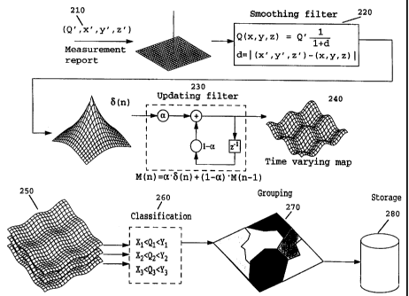
Fig. 2a shows an example of how the filtering and the storing
of the data are performed. At 210, the measurement report is
sent from the mobile station to the base station, wherein the
measurement report contains at least one quality measure and
information of the position. The quality measure is filtered
over the area by a smoothing filter in step 220. In this
example, a step 230 for processing through a filter having
isometric dependency is used where,
Q(x, y, z) = Q'~and
1 + d
d =J(x,y,z)-(x,Y,zj ,
where Q is an estimated value,
Q' is an input value of a quality measure, e.g. signal
strength,
d is the distance from the point (x', y', z') where the input
value Q' is measured and the running coordinates (x, y, z),
x, y, z are the running coordinates of a point in the area,
x', y', z' are the coordinates of the point for which the
input value Q' is measured.
CA 02351683 2001-05-16
WO 00/30384 PCT/SE99/01746
12
The filter does not have to be isometric i.e. to have an
equal dependency in all directions, since perhaps the
resolution in the z- direction needs to be higher than for the x- and y-
directions. The map, or the new function
Q(x,y,z) that we obtain from the smoothing filter at the
point of measurement n at the time t, is called 5(t) and is
used to update the old quality map M(t-1). Said quality map
M(t-1) may be stored in a buffer coupled to the updating
filter. The updating filter in step 230 can be an IIR filter
(Infinite Impulse Response) or a FIR filter (Finite Impulse
Response), but in this example it is an IIR filter of the
first order where
M (t) = a - S(t) + (1- a) = M (t -1),
where a is filter coefficient.
In step 240, a time varying map is kept for each quality
measure that is being used in the classifying step 260. These
maps are classified in step 260 according to some criteria,
e. g., that the signal strength is between -95 dBm and -105
dBm or the BER (Bit Error Rate) is larger than 10-b.
Identifying the areas where a combination of these
classifications is considered to be constant is called
grouping the data, which is performed in step 270. The final
map, that results from the grouping step 270, is stored, in
step 280, in a database, for later use.
The usage of the database is shown in the lowest part of fig.
2b. In step 290, a measurement report arrives to the system
and the position information is extracted. The position
information is used to, from the map in the database, extract
information of the radio conditions in the vicinity of the
CA 02351683 2001-05-16
WO 00/30384 PCT/SE99/01746
13
considered mobile station. The information of the radio con-
ditions is then used in step 295 to enhance the performance
of the radio network algorithms, such as hand-off, power
setting or channel selection. The output from the radio net-
work algorithms are then used in step 297 by the radio net-
work controller to control the system.
In another embodiment, the updated value from step 230 may
be buffered in a database, and several maps may be buffered
for each Q-value. However, this embodiment requires another
algorithm for extracting the information of the radio
conditions to be used in the radio network algorithms.
Figure 3 depicts a flowchart illustrating an example of a
method for the usage of the database.
In block 310, the area covered by this database is divided
into smaller parts of the area, called zones, where the
radio conditions in some term(s) are considered to be
similar or can at least be considered to be substantially
constant. In block 320, the zone in which the mobile
station is situated is selected, according to the position
report. In block 330, within each of these zones, the radio
conditions can be predicted more accurately and hence the
performance of the radio network algorithms can be
enhanced, these algorithms can for example be:
- to determine if a base station belongs to the active set,
e.g. for soft hand-off in a CDMA system (Code Division
Multiple Access), or macro diversity in general,
- to force a mobile station to make hand-off earlier than
scheduled due to some expected change, for example before
entering a tunnel,
CA 02351683 2001-05-16
WO 00/30384 PCT/SE99/01746
14
- to choose channel depending on in which zone the mobile
station is located,
- to choose power setting, in order to optimise the use of
energy, e.g. to use appropriate amount of energy,
to choose an appropriate base station, e.g. the base
station in a hierarchical cell structure providing the
best quality versus power consumption,
- to use said processed information to provide dynamic cell
size.
Figure 4 depicts a mobile station M in a cell C under
control of a base station BS. The cell C is divided into a
number of zones, zl-z7, where at least one radio condition
is considered to be similar or can at least be considered
to be substantially constant (e.g. signal strength on the
uplink or power requirement on the down link or wherein a
predetermined choice of channel is preferred) from a mobile
station in a zone to the base station BS. For example, zone
z1 provides the best signal quality as it is situated next
to the base station BS, and the signal quality might be
quite bad in zone z3 as a hill is situated between the base
station BS and zone z3. The base station observes that the
mobile station is about to leave a zone z6, which requires
a certain radio condition (e.g. a relatively high power on
the down link), and enter a zone z7, which require another
radio condition (e.g. a relatively low power on the down
link). The base station BS can thus adapt the transmission
on the down link (and e.g. save energy) or tune to a more
adequate channel.
CA 02351683 2001-05-16
WO 00/30384 PCT/SE99/01746
Figure 5 depicts a mobile station M travelling in the
direction of a tunnel. The mobile station M is under
control of a base station BS1. BS1 does not reach the
5 tunnel. A base station BS2 controls the area in the tunnel.
The database informs BS1 that the mobile station Ml soon
will enter the tunnel and thus loose contact with BS1. BS1
performs a hand-off in advance to BS2. Thus the mobile
station Ml can continue to communicate.
The invention being thus described, it will be obvious that
the same may be varied in many ways. Such variations are
not to be regarded as a departure from the scope of the
invention, and all such modifications as would be obvious
to one skilled in the art are intended to be included
within the scope of the following claims.