Note: Descriptions are shown in the official language in which they were submitted.
CA 02368821 2001-10-02
Method for Simulating a Battlefield
The present invention relates to a method of the type defined in the preamble
to Patent Claim l,
for simulating a battlefield.
The objective of such a battlefield simulation is to reproduce real combat
situations on a spatially
limited training area and thereby permit tactical training. All the manoeuvres
are monitored from
a central unit, and intervention in the combat situations is possible, should
this be necessary.
Depending on the combat situation, the combatants and the targets can exchange
roles, so that the
targets can then deliver fire power and the combatants become targets that are
shot at.
In one known method for simulating a battle field, in particular for
representing the battle-field
data that are generated (DE 40 26 207 A1), at least two vehicles, preferably
armoured vehicles
that are taking part in a military exercise, are each equipped with a dual
simulator that determines
combat and operating data, for example, the results achieved by gunnery and
the hits obtained,
quantities of ammunition, and the operational status of the vehicle. In order
to permit an
immediate and ongoing assessment of the situation of all vehicles taking part
in the exercise, and
do this in the form of a general overview in a central assessment centre, the
vehicles are in radio
contact with the central unit and transmit their position data, as well as the
combat and operating
data ascertained by the dual simulator, to the central unit, where a computer
assesses these data in
order to represent intermediate and/or end results and/or an overview of the
complete situation.
CA 02368821 2001-10-02
In a known system for combat simulation with combatants, e.g., armoured
vehicles, that are
moving about within a training area, (US 5 382 958), a central combat command
unit activates a
plurality of relay stations that are distributed throughout the training area
by radio. Each relay
station receives information with respect to position and time from a GPS.
Each relay station
repeatedly sends position information about the battle field within a time
frame, and selected
relay stations also send gunnery information that includes the type of
ammunition, range, and
effect. Using the information received from at least three relay stations, the
combatants can
determine their position relative to a point of impact that has been
transmitted.
US 4 744 761 describes a system that simulates the effectiveness of indirect
fire, e.g., artillery
fire, in which-depending on the type of ammunition selected and a selected
target-control signals
and, depending on the controls signals, a multitude of radio waves are
transmitted to the target
area and an indication is provided as to what in the selected target area has
been hit by the type
of ammunition fired. To this end, a master station is positioned close to the
gun that is firing, and
close to the target area there is a plurality of remotely controlled
substations as well as displays
that are associated with a plurality of objects located within the target
area. The master station
communicates by radio directly with the substations and, in their turn, the
substations emit radio
waves that are received by the display units within the target area. Within
the display units, a
decoding device determines whether on not the object that is linked to it has
been hit or not.
One known battlefield simulation system (US S 788 500) uses a laser for
simulating shot, and
this emits a laser light continuously (CW laser). The laser light is modulated
by pulse code
2
CA 02368821 2001-10-02
modulation (PCM) and pulse pause modulation (PPM) so that both the combatant
who fires the
shot as well as the type of weapons system firing to shot can be identified
unequivocally. All the
combatants are equipped with optical sensors to receive laser light. A
combatant that has been
shot at receives the information modulated onto the laser light by way of its
optical sensors and
from this derives an appropriate result, e.g., a hit or a miss and/or a
representation that shows the
effect of a hit.
More costly simulators, which are preferably used for tube-type weapons, e.g.,
tanks, use the
laser light of the shot simulator to range the target prior to a shot being
fired, to which end the
target is additionally fitted with reflectors that return the laser light. The
range to the target and
the position of the hit relative to the reflector can be determined, and these
are then transmitted
to the target.
Shot simulators that are based on laser light have various disadvantages. The
optical sensors
have to be attached to the outside of the combatants in such a way that said
combatants can be
engaged from any direction. During the battle exercise, steps must be taken to
ensure that no
sensor is covered over, e.g., by dirt. There must be an unobstructed optical
transmission path
between the target and the combatant that is delivering fire. Determination of
the hit position by
the firing combatant is extremely costly, and it is impossible to separate a
target from a plurality
of such targets that are being painted simultaneously by the laser. The range
of the shot
simulation is limited because the laser light must not be hazardous to the
observers' eyesight.
3
CA 02368821 2001-10-02
It is the objective of the present invention to describe a method for
battlefield simulation that
avoids the disadvantages set out heretofore.
This objective has been achieved by the features set out in Patent Claim 1.
The method according to the present invention entails the advantage that radio
transmission of
data is largely immune to interference and is not shielded by terrain
features, so that the
requirement for an unobstructed field of fire is eliminated.
The danger of becoming contaminated is slight both for the sender and the
receiver of the radio
transmission and, unlike the case of when lasers are used, no special measures
to protect the
combatants are needed. Furthermore, targets located behind cover, for example,
targets concealed
by buildings or dense vegetation and trees, which cannot be hit by a laser
shot, can also be
destroyed, because the actual beam of laser light always travels to the target
on a direct path,
whereas an actual shot, e.g., one fired from a tube-type weapon, follows a
parabolic trajectory.
In the event that several targets are located in the area of the fall of shot,
separation of the targets
is simple, and the different effects of shot impact on the various targets are
displayed.
Useful embodiments of the method according to the present invention, with
advantageous
developments and configurations of the present invention, are set out in the
secondary claims.
4
CA 02368821 2001-10-02
In one preferred embodiment of the present invention, the current position of
each combatant and
each target are continuously reported to the central unit and then, within the
central unit, are input
into a training area data base that contains position data referring to fixed
objects such as houses,
walls, streets, stands of trees, and the like. Thus, the central unit has a
continuously updated
overview of the combat situation and all of the combatants and targets
involved in combat.
In a preferred embodiment of the present invention, each target-and preferably
each combatant
and each target, since the two can exchange roles-has a data base that
contains ballistic tables for
all the weapons systems being used in the training area, such data bases also
including the types
of ammunition they fire, and with models for the type and degree of casualties
or damage caused
by a hit, as well as characteristics that identify the combatant or the
target. Thus, the targets have
what is needed to compute hits and to determine the effect that the hits will
have on a particular
target.
According to one preferred embodiment of the present invention, hypothetical
falls of shot are
determined in the central unit using the data sent by the firing combatant,
and with the help of
the ballistic tables that are in memory, and only the targets that are
endangered by their position
within the effective area of the fall a shot are addressed from the central
unit in order to exchange
data. When this is done, on the basis of the data base for the training area
that is stored in the
central unit, cover that is offered by buildings or trees in the direction of
the target is also taken
into account. The number of combatants and targets communicating with each
other
simultaneously is reduced to a minimum by this procedure.
CA 02368821 2001-10-02
According to one preferred embodiment of the present invention, when a
simulated shot is fired
by a firing combatant, the shot data such as direction, elevation, lead, and
position of the firing
weapon, the type of weapon and type of ammunition, as well as identification
of the combatant
delivering the fire is sent to a central unit and these shot data are
transmitted from the central unit
to the targets that are endangered, and these in their turn recalculate the
position of the
hypothetical fall of shot and inform the central unit of this together with
the identification of the
reporting target. Based on the computed position of the fall of shot and their
own positions and
movement at the time of impact, the targets determine the type and degree of
their casualties or
damage, and report this information to the central unit. In the event that the
target position and
the position of the hypothetical impact agree with respect to time and
position, a hit is indicated
visually and/or reported to the central unit.
The present invention will be described in greater detail below on the basis
of embodiments
shown in the drawings appended hereto. These drawings show the following:
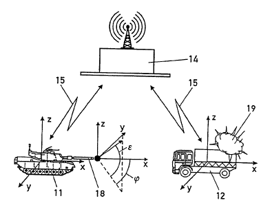
Figure 1: elements of a battle field with an actual combat situation;
Figure 2: a block diagram showing the battle field simulation method.
Figure 1 shows elements of a training area that is being used as a battle
field in which armed
combatants 11, for example, troops, tanks, guns, and the like, are in action
and fire simulated
shots at passive combatants hereinafter designated targets 12, which are, for
instance, troops,
tanks, guns, vehicles, and the like. In the embodiment shown in Figure 1, a
tank is shown as an
6
CA 02368821 2001-10-02
armed combatant 11, and a truck that is moving across the terrain is
designated as target 12. In
the event that the targets 12 also have a weapons system at their disposal,
then they can exchange
their roles at during the battle, so that target 12 is now the combatant
delivering fire and the
armed combatant 11 now represents the target. All combatants 11 and targets 12
are equipped
with a satellite-supported positioning apparatus, e.g., GPS or DGPS, which
continuously
determines the positions of the combatants 11 or of the targets 12, and with a
computer unit and
with a data bank and or data base (Figure 2) that contains ballistic tables
for all of the weapons
systems in use on the battlefield, statistical information relevant to all of
the weapons system in
use on the battle field, and models for the type of possible casualties or
damage that will be
caused in the event of a hit. Both the combatants 11 and the targets 12
possess radios with which
they can communicate with the central unit 14. Radio communications between
the central unit
14, the combatants 11, and the targets 12 are indicated by the arrows 15 shown
in Figure 1. The
central unit 14, which is similarly equipped with a radio, also has a computer
unit with a terrain
data base 16 that contains the positions of fixed objects in the terrain, such
as houses, walls,
roads, trees and the like, and a data base 17 which-as the in the case of the
targets 12 and armed
combatants 11-contains ballistic tables for all the weapons system being used
in the training
area, including information about the types of ammunition used by these.
During a combat exercise, all combatants 1 l and all targets 12 continuously
report their actual
positions as provided by the GPS (x, y, z coordinates of battle tanks and
trucks in Figure 1) to the
central unit 14, which stores them in the terrain data base 16; these stored
variables are
continuously updated. In the event of a simulated shot being fired by a
combatant 11 , the firing
7
CA 02368821 2001-10-02
data, such as the position of the weapon 18 that has been fired (x, y, z
coordinates in Figure 1 ),
the alignment of the weapon (elevation E, lead ~), type of weapon, type of
ammunition, and the
identification of the combatant 11 that is firing are all sent to the central
unit 14. Using these
firing data, the hypothetical, simulated, or virtual trajectory and the
hypothetical fall of shot are
determined in the central unit 14 with the knowledge from the data base 17.
The firing data are
transmitted from the central unit 14 to those targets 12 located within the
area affected by the
hypothetical fall of shot as computed by the central unit 14, which could be
hit or damaged,
which is to say, which could be endangered. The hypothetical fall of shot is
again determined by
the endangered targets 12 using the firing data about the firing combatant
that have been
transmitted and the knowledge from the data base 13; when this is done, their
own movement,
and the direction of such movement during the flight time of the projectile
are taken into
consideration. If their own position and the hypothetical fall of shot agree
by time and position,
the target provides a visual indication of a hit; this can be done, for
example, by emitting a flash
19, as is shown in Figure 1. At the same time, the hit is reported to the
central unit 14. If no
direct hit is identified, but the position of the target is only in the
immediate vicinity of the fall of
shot, the type and degree of possible casualties or damage to the target 12 is
determined using the
knowledge obtained from the data bank, and then reported to the central unit
14.
8