Note: Descriptions are shown in the official language in which they were submitted.
CA 02368978 2008-02-15
-1 -
Method for Locating and Identifying the Type and
Geometrical Dimensions of Hydrocarbon Deposits
Various and mostly incomplete methods, which partly complement each other, are
known for finding deposits of raw materials and other deposits causing
anomalies in the
crust of the earth. Historically, the detection of such deposits, in
particular oil and gas
deposits, occurred by accident. This is also still the case to a large extent
today and is
extremely unsatisfactory. On the basis of the frequency of such discoveries, a
system has
been developed which initially only related to knowledge of the geological
structure of
the earth and its development over time.
On this basis, methods have been developed which are largely of a technical
nature and
make confirmation of hypotheses easier but which are not suitable to make
definite
statements regarding the existence of deposits and their geographic extent.
With the
continuation of the development and new technical possibilities, methods are
known
today which at least facilitate locating of possible deposits. Such methods
include
infrared photographs taken from satellites, magnetic methods and seismic
methods,
which can provide information regarding the geologic structure and partially
also
regarding the type of the deposits. These methods are of the active type, as
well as of the
passive type.
The amount of knowledge in regard to searching for hydrocarbon deposits is
still very
limited, and it is largely limited to performing seismic, geologic,
geophysical or
geochemical explorations, all of which, however, still have a more or less
experimental
character and do not permit direct statements regarding the type of deposits.
Exact
statements regarding the type of the deposits can only be made once the
deposits are
physically detected.
Initially, an exploration by seismic methods is performed for finding
hydrocarbon
deposits in new regions. During this, a signal is generated by one or several
sources,
whose reflections at inhomogeneities are received by sensors (geophones), and
whose
chronological progress is evaluated for the identification of inhomogeneities
(propagation time measurement). The results of such explorations provide
information
CA 02368978 2001-09-28
-2. -
regarding the presence and the extent of inhomogeneities, but not with respect
to their
cause. Such explorations can be evaluated using two-dimensional, as well as
three-
dimensional methods. However, they are not suited for determining the type of
the
inhomogeneity but only provide information as to its existence, which is
important but
not sufficient.
Many seismic methods are based on the investigation of longitudinal
wavefronts,
triggered by one or more sources, such as explosions or mechanical vibrations,
and
whose simple or multiple reflections at inhomogeneities of the subsurface (of
the
transport medium, of the medium within which the waves are propagated) are
evaluated
for geometrically identifying these by receiving the returning wavefront by
sensors (e.g.
geophones) distributed over the terrain. It is possible by displacement of the
propagation
time and damping between the initial signal and the received signal to draw
conclusions
regarding the geometric extent of geologic formations in the measuring zone.
Basically all these methods operate by means of a very broad frequency
spectrum,
mainly above 30 Hz. Although it is possible by evaluating the reflecitions to
recognize
formations as an image of the reflection properties, it is not possible to
determine the
type of these formations. Therefore such explorations are called indirect.
Only further "mechanical" explorations, namely the driving of exploration bore
holes and
the sequential examination of drilling cores, provide information regarding
the type of
rocks in the formations, wherein the information is not definitive as long as
a bore hole
has not been sunk exactly into the deposit.
These known methods are very expensive to perform, and their result can
consist of the
finding that the deposit found is not the type of deposit sought. It is known
that the rate
of success of these methods is far below 40 %.
Methods have also been proposed for the identification of raw material
deposits which
utilize the resonance of the entire mass of a deposit as an indicator of its
existence and
also its type.
CA 02368978 2001-09-28
-3 -
Here, the effect of "resonance" on one or several mechanical oscillators (an
electrical
analogy would be an absorption circuit) is to be utilized. One disacivantage
of these
known methods is that they are almost impossible to perform tec'hnically, and
the
frequency of the resonance to be excited, to the extent that it is based on
workable
deposits, is strictly a function of the geometric spread of the deposits, and
not their
nature. In this case, no characteristic values exist for defined types of
dc;posits.
It is the object of this invention to provide a method by which it is possible
to directly
determine the presence and the type of hydrocarbon deposits. In contrast to
the known
methods, this method provides both a statement regarding the type of the
deposit as well
as its geographic position and extent.
In general, this method relates to the presence of multiphase fluid systems in
porous
bodies, and in particular, to the exploration of subterranean hydrocarbon
deposits.
The method of this invention provides a direct statement regarding the type
and extent of
deposits without necessarily first sinking exploration drill holes. It tttus
saves costs, is
ecologically advantageous and is also
suitable for monitoring changes in the deposits, which is important for the
efficient
exploitation of such deposits.
This object is achieved by a method characterized by the properties defined in
Claim 1.
Advantageous embodiments of the invention are described in the subordinate
claims.
The method proposed by this invention relates to the geometric location and
the
determination of the type of deposits, or of deposits causing anomalies in the
crust of the
earth, in particular to the presence of oil, gas, gas condensate or,
generally,
hydrocarbons. Deposits are understood to be the presence of any kind of
significant, in
particular economically usable concentrations, but also bodies of any type of
a
significant volume which can be demarcated with respect to their surroundings.
In
contrast to the known methods, the method proposed by this invention provides
a
statement regarding the type and nature of the deposits, as well as a
statement regarding
CA 02368978 2001-09-28
-4 -
their geographic position and geometric extent. The method of this invention
is not an
indirect method, wherein conclusions are drawn from secondary events, but a
direct
method which can provide a statement of a quantitative nature, as well as a
qualitative
nature.
During examination of deposits consisting of multiphase fluid systems in
porous bodies,
an effect can be observed, which can be used to determine the type of the
deposits and
which is the subject of this invention:
A hydrocarbon deposit accumulated in a "collector" (i.e. a lithological
formation suitable
for containing hydrocarbons) is always a multiphase system with different
"interior
energy". This system is capable of taking on different energetic states. The
transition
from one energy state into another is always connected with energy absorption
or energy
release.
Energy release always manifests itself by the emission of a frequency
characteristic of
the fluid system, and therefore of the type and nature of the deposit. This
frequency is
essentially determined by the composition of the fluid system, by the porosity
of the
collector, and by the permeability of the collector and does not correspond to
the natural
frequency of the deposit which can, for example, be generated by the riatural
vibration of
the mass volume, i.e. it is not a function of the geometry of the deposil:.
Moreover, the effect is not a resonance effect in the sense of a periodically
excited
resonator, but the energy release with the characteristic freque:ncies takes
place
chaotically. The frequency of energy releases is a function of the amount of
the energy
supplied from the outside. No connection has been observed between the
frequency of
the energy release and the characteristic frequency emitted, however, a
connection has
been observed between the frequency of the energy releases and the volume of
the
multiphase system. For hydrocarbon deposits, the emitted characteristiic
frequency lies in
the range between 0.1 and approximately 10 Hz. Thus, the following
characteristic
frequencies can be observed:
F oil approximately equal to2.3 Hz
CA 02368978 2001-09-28
-5 -
F gas condensate 2.8 Hz
F gas 3.2 Hz
F water 5=8 1-Iz
However, the frequencies are a function of the properties of the respective
geomorphologic and hydrostatic/hydrodynamic system. Inter alia, they are
dependent of
the porosity, the permeability, the pressure, the temperature and the
viscosity.
Excitation takes place by supplying energy, both in the form of thermal energy
as well as
mechanical energy, caused by the natural tectonic ground noise or by other
quasi-
mechanical energy sources, for example subterranean pumps.
The so-called ground noise extends in a broad spectrum of mostly longitudinal
mechanical waves with a distribution of 1/f (f = frequency), in the
undisturbed case.
The longitudinal waves are propagated through the deposit and can be,
registered on the
surface of the earth in a known manner by sensitive sensors.
While passing through the deposit, the longitudinal waves give up a portion of
their
energy to the deposit, but also pick up a portion of energy in the form af a
modulation.
The process of absorption and energy release in the fluid systeni, which
partially
represents the transmission medium for the longitudinal waves caused by the
ground
noise, is a non-linear process.
Thus, all waves caused by the earth body and penetrating the deposit undergo a
modulation with the characteristic frequency or frequencies of the fluid
system.
Here, the characteristic modulation frequencies can occur multiplied and next
to each
other in the spectrum because, depending on the composition of the fluid
system, they
are different and therefore the respectively dominant frequency changes at
different
locations at the individual measuring points across a deposit.
CA 02368978 2001-09-28
-6 -
The method of this invention uses this effect for identifying hydrocarbon
deposits in the
ground.
The fact that hydrocarbon deposits always occur in connection with water, and
that both
media have a characteristic frequency in separate frequency ranges, is
essentially used
here. For example, hydrocarbons can be observed in the range between 2.0 to
3.5 Hz
(hydrocarbon window) and water in the range between 4.5 and 6.5 Hz (water
window).
Simultaneous measurement of these anomalies in separate frequency ranges, and
the
correlation of the relative maxima in these frequency ranges with respect to
frequency
and amplitude is one essential subject of this invention.
Thus, if the two amplitude values of the maxima of the separate frequency
ranges are
placed into a correlation to each other, it is possible to draw conclusions
from this
correlation B
AFIi
B i = ------
AF2i
(wherein AF I is an amplitude maximum in the hydrocarbon window and AF2 is an
amplitude maximum in the water window, each respectively for the i-th
measuring point)
and its course over the suspected deposit regarding the location of the
borders of the
deposit, which is one object of this invention.
There is a value Bmin for which Bi > B min>1 applies, which determilies the
borders of
the deposit. However, this value Bmin can only be exactly determined from a
correlation
of the deposit to be examined with already known deposits and with other
geologic and
seismic data. But in a first approximation for determining the deposit this is
not
important, since there is only interest at all in locations for which Bi is at
least > 1.
CA 02368978 2001-09-28
-7 -
It is also possible to draw conclusions regarding the type of the deposit from
the course
of the frequencies of the maxima in the area of the deposit.
In accordance with this invention, one or several three-dimensionally
operating sensors
(seismometers) which operate in the frequency range between 0.1 and 20 Hz, are
used
for detecting these anomalies in the spectrum of the ground noise by measuring
techniques.
The signal detected by the sensors over an extended period of time is filtered
and
subjected to a frequency analysis, and searched for the presence of
anornalies.
The detection of these signals by measuring techniques and the recognition of
the
anomalies usually requires a great cost outlay in apparatus and matheniatics,
because the
signal to be detected is hidden in the noise spectrum because of its small
amplitude, and
because the characteristic frequencies are not strictly monochromatic, but
distributed
over a defined range of the spectrum.
Therefore, in accordance with this invention an identification of the
anomalies (the
useful signals) only occurs from a comparison of the spectra of a multitude of
measuring
points on a profile across a deposit.
The pickup of primary signals preferably occurs by a group of at least three
sensors
simultaneously, however, it is also possible to combine individual
chronologically offset
recordings into a pseudo-array.
A correlation between the received measurement data and seisrnic data and the
lithological parameters of the suspected collector also makes possible the
determination
of the volume (thickness) of the examined deposit.
For this purpose, it is also recommendable to compare the received measured
data with
data from already known geologically analogous deposits.
CA 02368978 2001-09-28
-8 -
This method of information-theoretical evaluation is largely known (cf. German
Patent
DE 28 43 849 C3) and is used for evaluating the information obtained in
accordance with
this invention, wherein software, which was especially developed for this, is
preferably
employed.
Thus the method of this invention, which provides information regarding the
type and
location of the deposits, has considerable economic advantages and also
ecological
advantages in comparison with the methods known and applied so fa.r. The
number of
test drillings, which up to now was necessary, can be drastically reduced with
this
invention, which results in a considerable reduction of the costs required for
an
exploration. At the same time, destruction of the environment is prevented to
a large
extent, which otherwise had to be accepted when sinking test bores.
This invention will be explained in what follows by means of phases of a flow
chart,
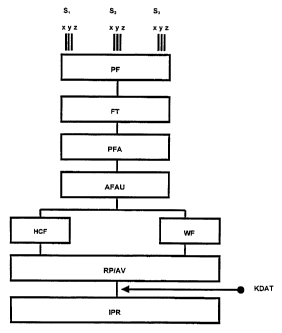
making reference to schematic drawings, wherein:
Fig. I is a schematic diagram showing the processing of received measured
data,
wherein:
PF = Primary data filter
FT = Fourier transformation
PFA = Phase/frequency/amplitude comparison
AFAU = Amplitude/frequency evaluation
HCF = Hydrocarbon window
WF= Water window
RP/AV = Reservoir profile/amplitude ratio
KDAT = Correction data from known scenarios
IPR = Interpretation of the course of the reservoir;
Fig. 2 is a schematic diagram showing a measuring arrangement for detecting
the
primary measuring data for a measuring point, wherein:
Sl/S2/S3 = Sensors
CA 02368978 2001-09-28
-9 -
AE = Recording unit (data recorder)
Fig. 3 shows a schematic diagram of a distribution of measuring points over a
reservoir,
wherein:
Pi = Measuring profiles
Mik = Measuring points
R = Reservoir
Fig. 4 shows a graphical representation of a typical frequency distribution of
the
correlated signal of the sensor group when hydrocarbon is present;
Fig. 5 shows a graphical representation of a typical frequency distribution of
the
correlated signal of the sensor group when hydrocarbon is not present;
Fig. 6 shows a graphical representation of a typical frequency distribution
when water is
present;
Fig. 7 is a graphical representation of a typical measuring profile across a
deposit,
showing amplitude values of the hydrocarbon window;
Fig. 8 is a graphical representation of a typical measuring profile across a
deposit,
showing amplitude values of the water window; and
Fig. 9 is a graphical representation of a typical course of the ratio of'the
maxima from
the hydrocarbon window and the water window.
Phase 1: The measuring data is picked up by the sensors S 1, S2, S:3 by means
of the
arrangement shown in Fig. 2, and is recorded as digital information in the
recorder AE. Recording takes place simultaneously for all sensors S1, S2, S3
and is separated into the components x, y, z.
The recording time is on the order of several minutes for each individual
measurement.
CA 02368978 2001-09-28
-I0 -
In accordance with Fig. 3, the measurements take place at the measuring
points Mik along the profiles Pi.
Phase 2: Following processing in a correlation filter (PF), the measured data
(primary
data) is subjected to a frequency analysis (FT), and following the comparison
of phase, frequency and amplitude (PFA), the frequency and amplitude values
are determined from the correlated data and transferred to the appropriate
windows, the hydrocarbon window (HCF) and the water window (WF).
Phase 3 : A reservoir profile is produced from the received data, and the
course of the
amplitude ratio of the maxima from the separate frequency windows is
determined.
Phase 4: These data are correlated with those from known scenarios, which
makes
possible an interpretation (IPR) of the geometry and the contents of the
deposit.
In connection with this basic description of the process, it is essential ta
add that it is
advantageous to perform the measurements in a second step with a multitude of
sensors
simultaneously over the entire deposit. However, this only makes sense if the
presence of
hydrocarbons and the borders of the deposit are already known.
In this case the totality of all measuring points Mik constitutes a sensor
group which is
equipped only with one three-dimensional sensor at each measuring point
While performing the measurements themselves it makes sense for technical
reasons to
digitize the measured data in a known manner directly at the sensor (S) and to
transmit
them to the evaluation unit (AE) via a telemetry system. This is of particular
advantage if
the sensors (S) are not stationarily arranged.
In its application, the method of this invention is not limited to deposits in
the interior of
the earth, but can also be applied to any type of multiphase fluid systems in
porous
materials.
CA 02368978 2001-09-28
-11 -
The method of this invention can be employed both on shore and off shore at
any
arbitrary water depths.