Note: Descriptions are shown in the official language in which they were submitted.
CA 02377958 2004-06-30
AIRBORNE CONSTELLATION OF COMMUNICATION
PLATFORMS AND METHOD
TECHNICAL FIELD OF THE INVENTION
The present invention relates to a constellation of small, airborne
communications
platforms, and more particularly, to a plurality of small, lighter-than-air
communications
platforms spaced-apart and floating in the stratospheric layer of the Earth's
atmosphere
over a contiguous geographic area.
1o BACKGROUND OF THE INVENTION
Until recently, all communications satellites were located on one orbit called
the
geosynchronous arc, which is located 22,300 miles above the Earth's equator.
Since
international treaties required satellites to be spaced two degrees apart,
there were only
180 sites on geosynchronous orbit. An optimally-designed three-stage chemical
rocket
typically must be 94% propellant at launch to reach geosynchronous orbit,
which, after
allocating about 5.6% of the weight for the rocket, only leaves about 0.4% of
the initial
launch weight for the satellite. To put this in perspective, a typical 3,000
1b. automobile
with the same performance would only be able to carry one 200 1b. person,
would need a
8,400 gallon fuel tank, and would be junked after one trip! Finally, although
the NASA
2o space shuttle can service a few very low orbit satellites at great expense,
most satellites
cannot be serviced or upgraded after being launched.
Currently, since there are a limited number of sites on the geosynchronous
orbit,
geosynchronous satellites are growing in size and performance, now being able
to
broadcast television signals directly to homes. Recently, additional satellite
networks
have been deployed that do not require a geosynchronous orbit. All of these
new
networks have launched smaller communications satellites into much lower
orbits where
there are an unlimited number of sites. Because the satellites required for a
network are
more numerous and because the satellites are smaller, up to 8 satellites per
rocket have
-1-
CA 02377958 2001-12-28
WO 01/01710 PCT/US00/15607
been launched. Although satellites have become smaller and more numerous,
there are
still no "personal satellites" and no mass producers of consumer products in
the satellite
industry today.
It might be estimated that a network of microsatellites in low Earth orbit and
ground
equipment to accommodate the tracking, transmission, reception, signal handoff
among
the plurality of microsatellites and necessary system network for a voice
system would
cost at least $3 billion to deploy. Within four years of deploying a system,
each one of five
million subscribers might be expected to invest as much as $3,000 in the
equipment,
which results in a total combined investment by the users in the new equipment
of about
$15 billion. The cost of deploying a smaller system of low Earth orbit
advanced
messaging satellites might be estimated at about $475 million. Such a system
might be
expected to serve two to three million subscribers, each with user equipment
costing
$300-$1,000. Thus, the total investments by the users for their equipment may
be at least
$600 million.
There is currently an industry involving radiosondes for purposes of gathering
weather information. Radiosondes are the instrument packages launched on
weather
balloons to gather weather data. Radiosondes are launched from a network of
sites
around the world at noon and at midnight Greenwich Mean Time each day. The
weather
service radiosondes collect temperature, humidity, pressure and wind data as
they rise
from the surface of the Earth to approximately 100,000 feet during a two-hour
flight. This
data is then input in atmospheric models that are run on supercomputers. The
information gathered from the network of ascending radiosondes is critical in
predicting
the weather. Most countries of the world are bound by treaty to launch
radiosondes from
designated sites and to share the data with other countries. Currently there
are about
800,000 radiosondes launched each year throughout the world. This number
represents
the 997 global weather stations launching two radiosondes per day, 365 days
per year
(727,000) plus a small number of radiosondes launched for military and
research
purposes. About 18% of radiosondes are recovered, reconditioned and reclaimed,
resulting in new production of about 650,000 weather-gathering radiosondes per
year.
-2-
CA 02377958 2001-12-28
WO 01/01710 PCT/US00/15607
The location systems currently used to track weather balloons are either being
deactivated (Omega, beginning before the year 2000, and Loran-C, shortly after
the year
2000) or are so old that the operation and maintenance is becoming
prohibitively
expensive (radars and radiotheodolites). Changes in radiosonde systems are
usually
very slow, since meteorologists study climatic trends by comparing data
collected over
decades. Thus, they are very leery of any changes that may introduce new
biases into
data as it is collected. This is evident from the fact that major users, like
the U.S. National
Weather Service (NWS) still use analogue radiosondes tracked by
radiotheodolites when
digital, navaid sondes have been around for many years. Tightening of
governmental
budgets have made some users unable to pay for new technology required. There
presently is a push in the sonde marketplace to convert to using the Global
Positioning
System (GPS) for wind tracking on radiosondes. From 1995 to 1998, the NWS
tried and
failed to get the U.S. Congress to fund a program to develop a GPS tracking
system for
the U.S. Observation Network. This inability to obtain the necessary newer
technology
to replace old and unsupportable radiosonde infrastructure is occurring
simultaneously
with the reallocation of the radiosonde's RF spectrum to commercial uses.
Radiosondes
have traditionally transmitted at 400 MHZ for navaid sondes and 1680 MHZ for
radiotheodolite sondes. The 400 MHZ band may be auctioned off by the Federal
Communications Commission (FCC) in the United States for simultaneous use by
commercial services. Thus, interference is increasing and sondes may be forced
to use
narrower bandwidths with digital downlinks instead of the wide bands with
analogue
downlinks still in common use.
Very large and expensive NASA balloons have been individually launched and
maintained at a floating altitude for extended periods of time. These balloons
carry
hundreds of pounds of equipment and cost tens of thousands of dollars each.
The single
balloons do not have the capability of line-of-sight continuous coverage of
extended
geographic areas because of drifting.
Personal communications services (PCS) is a new category of digital services
that
the FCC started auctioning spectrum for in 1994. PCS is split into two
categories: broad
band and narrow band PCS. The broad band category is primarily for voice
services and
-3-
CA 02377958 2001-12-28
WO 01/01710 PCT/US00/15607
PCS broad band phones now compete with traditional cellular phones. The narrow
band
category is for advanced messaging, which is essentially two-way paging. The
paging
industry sees advanced messaging as being the mobile extension of one's e-mail
account, just as a cellular phone has been the mobile extension of one's
desktop phone.
Nationwide narrow band PCS (NPCS) was the first spectrum ever auctioned by the
FCC.
About 30 regional and nationwide NPCS licenses have been auctioned and sold to
private
commercial ventures. The fact that the spectrum was auctioned is significant
in that there
are fewer restrictions on the use of this spectrum than on the use of
traditional spectrum
licensed from the FCC. Before auctions, the FCC granted spectrum on a
piecemeal
basis, and companies had to prove that they were using the airwaves for the
"public
good." Usually there was very specific federal regulation on how the frequency
could be
used. Since companies paid for their PC3 licen es; they essentially own the
spectrum.
The FCC imposed only minimal regulations to prevent systems from interfering
with other
carriers' and other countries' systems. Additionally, the FCC and Industry
Canada
reached what is known as a Terrestrial Radio Communication Agreement and
Arrangement in which Canada allocated the same frequencies for NPCS with the
same
channel structure as the auctioned spectrum for the NPCS in the United States.
This
made cross-boarder NPCS possible and in 1996, at least one paging system
company
was granted an NPCS license in Canada to operate on the same frequencies as
its U.S.
licensee. Mexico also has specified the same channel spacing as used in the
United
States.
One of the goals of the FCC is to encourage providing radio frequency (RF)
communications services to consumers in rural areas at an affordable price.
This market
has been largely ignored by the larger communications companies because of the
diminishing return on investment in providing wireless communications to
sparsely
populated areas. These wireless services include paging, advanced messaging,
telemetry, voice, etc. Although both voice and messaging services are
available to rural
areas using satellite systems, the costs are generally in the thousands of
dollars per unit
and well out of reach of most consumers. In addition satellite systems have
problems
providing services in urban areas because they lack the signal strength
necessary for
providing building penetration.
-4-
CA 02377958 2001-12-28
WO 01/01710 PCT/US00/15607
OBJECTS AND ADVANTAGES OF THE INVENTION
The present invention overcomes drawbacks of prior communications satellites,
by using small and relatively inexpensive microelectronics to incorporate most
of the
functions provided by existing communications satellites in small, lighter-
than-air
communications platforms. In particular, a plurality of lighter-than-air
balloons forming a
constellation are designed to carry microelectronic communications equipment
into a layer
of the Earth's atmosphere called the stratosphere. The weight of these
platforms is
approximately 100 to 1,000 times less than the micro-satellites currently
launched into
non-geosynchronous orbits. For convenient reference, the airborne
communications
platforms or balloons carrying a payload of electronic communications and
control
equipment have sometimes been referred to herein as "stratospheric
nanosatellites" or
"SNS" for short. In the metric system, the "nano" prefix signifies units 1,000
times smaller
than the "micro" prefix. The SNS invention eliminates the need for a rocket to
propel the
satellite into orbit. Synchronized airborne launching of a plurality of the
SNS platforms at
spaced-apart geographical locations provides a low cost constellation of
satellites. The
SNS platforms rise after launch to a controlled, adjustable altitude where
they migrate
over the geographic area according to atmospheric and the stratospheric
weather
conditions and particularly the winds. The SNS platforms may be raised or
lowered in
altitude by gas venting or ballast drop in order to catch prevailing winds
favorable to keep
the SNS platforms evenly spaced apart. The platforms are caused to rapidly
descend
when no longer needed. Additional launches of additional platforms fill
excessive gaps
occurring in the constellation
Existing user equipment designed for terrestrial wireless communications can
work
with the SNS system of the present invention. This is not the case in the
traditional
communications satellite industry, since either the communications satellites
are very far
from the user (more than 22,000 miles for geosynchronous satellites) making
the signal
too weak without specialized user equipment, or the satellites travel at high
speeds
relative to the users on the ground (more than about 36,000 mph for low earth
orbit
satellites) causing frequency errors in the receiver. The SNS platform is, at
most, about
175 miles (280 kilometers) from the ground user, depending upon the altitude
and the
radial coverage range from the particular platform among the plurality of
platforms
-5-
CA 02377958 2001-12-28
WO 01/01710 PCT/US00/15607
covering the geographic area. Moreover, the airborne platforms move at speeds
approximating the speed of an automobile (between about zero and 80 mph at
their float
altitude). Compatibility with existing wireless communications systems is a
significant
advantage because when deploying a new communications system, the user
equipment
investment is always the largest total investment required.
In contrast to the large deployment and new equipment costs for orbiting
satellite
systems, the present invention provides a low cost alternative that does not
require new
subscriber equipment. Thus, a benefit of the SNS System is an advanced
messaging
SNS network that is compatible with standard one-way and two-way pagers
already in
existence and already in use with tower-based transceiver networks. Even
without
considering deploying of the SNS system, market analysts predict 35 million
users will be
carrying compatible, standard two-way pager equipment by the year 2003. At,
for
example, $100/unit, this represents an investment by users of over $3.5
billion. These
users can receive the enhanced coverage of the inventive SNS platform network
as an
extension of their present service simply by electing to pay the monthly and
incremental
usage fees. There are no up-front costs for new user equipment or training and
no need
to change the user's habits and burden them with carrying more than one pager
or other
communications device as is the case with current satellite pagers.
Furthermore, the inventive SNS system, when performing advanced messaging,
uses a communications protocol or pager protocol that is being adopted
internationally.
International opportunities for the new system are at least equal to the U.S.
potential. The
SNS System may utilize other popular paging protocols as well. The system also
has
uses beyond personal paging for other communications, remote imaging, infrared
scanning, equipment tracking and weather data collection services.
It will also be beneficial for the National Weather Service (NWS) to consider
utilizing the current SNS invention as a replacement system capable of
providing the
NWS with required information during the ascent of SNS platforms. GPS
information
available from the SNS Platform could provide the desired wind information the
NWS
needs but is unable to afford. Existing NWS launching facilities might even be
used as
-6-
CA 02377958 2001-12-28
WO 01/01710 PCT/US00/15607
SNS launch, tracking and communications sites. After the ascent and
transmission of
weather data to the NWS, the platform would then be controlled to float at a
regulated
altitude and to provide other commercial communications services. The NWS
sondes
could be removably attached and dropped as ballast after the ascent is
complete and the
desired information therefrom has been transmitted to the NWS. The attached
radiosondes could use exactly the same sensors utilized in the current
radiosondes in
order to keep the data consistant with current radiosonde data.
The inventive SNS network is uniquely designed to cover large areas and to use
dedicated frequencies on a national, and ideally, on an international basis,
between
bordering countries. It is beneficial to allocate nationwide, or ideally
international
dedicated frequencies to the SNS system due to the large coverage circles of
each of the
SNS airborne platforms. Overlapping use of the same frequency without time
multiplexing
the signals would most likely cause interference at the receiver. The System
will optimally
work within a range of frequencies designated the "Narrowband Personal
Communications Services" or "NPCS" spectrum. Moreover, the NPCS industry in
the
U.S. has generally agreed on a standard two-way messaging protocol called
"ReFLEX"
(ReFLEX is a trademark of Motorola, Inc.). ReFLEX is a protocol that uses a
Time
Division Multiple Access (TDMA) system. The ReFLEX protocol is an extension of
the
FLEX protocol designed by Motorola and is a synchronous protocol where there
are 128
frames in a four-minute cycle. The start of each frame is coordinated
nationwide using
GPS technology for timing. This will allow a single frequency to be shared
between the
SNS network of the present invention and existing terrestrial satellite
networks by simply
allocating a certain number of frames to each network during each four-minute
cycle.
Thus, the disclosed SNS system can either operate on its own dedicated
frequencies or
interoperate with terrestrial systems on the same channel and never transmit
on top of
each other. This is unique to TDMA and is preferably incorporated into the new
SNS
system.
While the TDMA system is used by the preferred FLEX and ReFLEX protocols,
the SNS invention may also work using other systems such as Code Division
Multiple
Access (CDMA) and even Frequency Division Multiple Access (FDMA) systems. Code
-7-
CA 02377958 2001-12-28
WO 01/01710 PCTNS00/15607
Division Multiple Access (CDMA) spreads the digitized data over an entire
available
bandwidth. Multiple data streams are laid over each other on the channel
(sometimes
referred to as spread spectrum technique), with each datastream assigned a
unique
sequence code. While the unique sequence code can provide a very efficient use
of
bandwidth, it nevertheless is highly complex and expensive. The FDMA system
assigns
each datastream its own frequency. Although this provides a system that is
fairly easy
to implement and has a low cost from an equipment standpoint, it nevertheless
results in
a highly inefficient use of bandwidth.
ReFLEX has 128 discreet time slots or frames in a four minute period. The SNS
system may use its own frequencies or it may share the time slots with a
partnering
paging carrier. The TDMA system used by ReFLEX provides efficient use of
bandwidth.
It has some complexity and associated equipment cost. However, the complexity
continues to be more easily handled with high speed microprocessors and the
equipment
cost continues to be reduced.
On one frequency, the 128 time slots or frames that the ReFLEX protocol breaks
each four minute cycle into, can be shared by the SNS system with other paging
antennas and terrestrial towers that may have overlapping geographic coverage.
A single
pager may be able to receive the broadcast from multiple platforms and
terrestrial towers,
but because each platform or tower with adjoining coverage is allotted a
specific frame
or specific frames, the pager "hears" only one transmitter in each time slot.
It is an object
of the present invention to provide a construction of communications platforms
that may
be dynamically assigned new frames in which to transmit as the platforms drift
in order
to make sure that a pager receives transmissions from only one transmitter in
the same
frame.
Also it is an object of the present invention that the time slots may be
dynamically
reassigned so that at any given time or location one platform may have a
greater number
of available time slots than another in order to provide more capacity to
platforms that
may need higher capacity. Dynamic frame allocation (or dynamic capacity
allocation), is
a complex task. At any time that more frames are allotted to one platform, all
other
_g_
CA 02377958 2001-12-28
WO 01/01710 PCT/US00/15607
platforms that have overlapping coverage with that one platform lose access to
the frames
that are assigned and therefore lose capacity. Nevertheless, the ability to
have dynamic
frame allocation will facilitate maximizing capacity of the entire system by
efficiently using
all available time slots to their greatest capacity while minimizing
allocation of time slots
or frames in geographic areas with low communications capacity requirements.
Also although the ReFLEX two-way paging protocol using TDMA as described
above is preferred, it is also an object of the present invention that the SNS
may also be
compatible with other pager protocols. For example, three other primary pager
protocols
include FLEX, POCSAG, and ERMES. The FLEX protocol is the one-way paging
system
that is the predecessor of ReFLEX. POCSAG is an older paging standard for one-
way
communications and is less efficient. Nevertheless, most pagers in the U.S.
are still
POCSAG compatible even though FLEX has higher noise immunity, a higher
throughput
and is becoming the standard in the U.S. and abroad (except Europe) for one-
way
paging. The ERMES paging protocol is the one-way paging European standard
(currently
governmentally enforced). The SNS system could also be appropriately
configured in its
circuitry to handle communications according to the ERMES protocol and
therefore is
adaptable to European usage as well.
In contrast to most voice and paging networks where many different protocols
are
used over a wide range of frequencies, NPCS contains a near contiguous set of
nationwide frequencies in which nationwide narrowband PCS licensees have
adopted the
FLEX/ReFLEX protocol.
The present inventive SNS system benefits from a nationwide consistency of
frequencies and protocols so that it can relatively easily operate across all
NPCS
channels owned by any or all of the nationwide carriers if need be. Minimal
governmental
regulation of the NPCS bands also allow the new SNS system, which was unknown
when
the NPCS regulations were drafted, to operate in the NPCS bands without
violating
current regulations. Since the NPCS licensees essentially own the frequencies
purchased at auction, and the inventive SNS system can compatibly use the same
frequencies with permission from the purchaser, additional licenses from the
FCC may
_g_
CA 02377958 2001-12-28
WO 01/01710 PCT/US00/15607
not be needed. This unique feature also saves two or three years in start-up
time that it
can sometimes take in order to pursue separate licenses.
As discussed briefly above, in addition to minimizing the regulatory hurdles,
the
new SNS network has a huge advantage in that it does not require new,
specialized user
equipment. It is expected that there may be as many as between 6-15 million
units of
compatible user equipment operating off existing terrestrial networks. These
can simply
be added to the new SNS system using inexpensive system programming and
thereby
receive the expanded, more complete, coverage of the contiguous geographic
area
provided by the constellation of floating communications platforms according
to the
present invention. To the NPCS carrier, the new system can provide complete
communication coverage, particularly coverage in remote non-metropolitan
areas.
Since existing paging equipment owners and users may acquire the expanded
coverage provided by the present invention through their existing carrier, the
decision to
expand coverage can be as simple as checking a box on their monthly bill. They
could
keep their current paging company, and simply add the benefit of remote area
coverage
provided by the SNS. No new equipment is needed and no start-up time is needed
to
learn the features of a new electronic device. There is simply improved
coverage for the
user without changing equipment.
A very important benefit of the inventive SNS network is the significant
improvement in complete remote area geographic coverage. Currently, wireless
data
coverage is a patchwork of covered high density population areas, primarily
around
metropolitan areas. The SNS network works cooperatively with the existing
coverage
areas and fills in all the low density population and thus low communication
traffic areas
all using the same subscriber device. The governmental regulations governing
NPCS
systems require minimum system build-outs for all licensees. For example, by
about
1999, a nationwide licensee providing NPCS must service at least 37.5% of the
U.S.
population or 750,000 square kilometers, and by the year 2004, a NPCS licensee
must
service at least 75% of the U.S. population, or 1,500,000 square kilometers.
Since the
population is very concentrated, prior systems have been required to build
towers for
-10-
CA 02377958 2001-12-28
WO 01/01710 PCT/US00/15607
coverage over a very small percentage of the total landmass. In fact, the
minimum area
requirement for the 1999 and for the 2004 population service requirements
correspond
to approximately 8% and 16% of the total U.S. landmass, respectively, because
of the
high population density in U.S. cities. For example, covering 90% of the
population
requires a carrier to build out only about 20% of the country's total
landmass. Servicing
areas of low population density is more expensive for prior systems since
tower
transmitter/transceivers have a short range requiring much more equipment per
potential
customer. Thus, few prior carriers have systems that cover more than 90% of
the
population because of the diminishing returns. Many established wireless data
carriers
are built out only to about 70%-80%.
The present invention is designed to provide substantially 100% coverage and
can
be compatibly combined with existing wireless carrier systems and networks
such that
the high density build-out by prior paging system carriers handles the high
population
density geographic areas and the low population density or remote areas,
wherever they
might be located within the contiguous geographic area, are handled by the
inventive
SNS system. The SNS system is complementary to high density tower paging
systems.
Thus, although the SNS system has a lower total signal handling capacity when
compared to high population density tower systems, it provides complete
geographic
coverage so that subscribers in or traveling through remote areas are provided
with the
additional coverage of the SNS system. Subscribers are always within the range
of
paging services or other compatible communications services using a single
device. The
SNS system may also reallocate capacity on a regional basis by launching more
SNS
platforms or by reallocating the frequency use dynamically among the
neighboring
platforms.
The SNS system also has uses beyond personal paging for other communications
including voice, remote imaging, infrared scanning, equipment tracking and
weather data
collection services. Broadband PCS (BPCS) phones that have come to market in
the
past year all offer an advanced messaging service call Short Messaging Service
(SMS).
The SNS system could page a subscriber's phone when the phone was out of the
BPCS
phone service area. BPCS voice service may also be possible with an SNS
system.
-11-
CA 02377958 2005-07-28
Another potential application for SNS technology is the remote imaging market.
Governments, city planners, farmers, environmentalists, mapmakers, and real
estate
developers all rely on aerial or satellite photos. Worldwide, this market is
over $1.4
billion. Since an SNS is over twenty times closer to the subject than a
satellite, SNS can
achieve one-meter resolution with only a 0.75-inch diameter lens. Weather data
from the
extended stay in the stratosphere can be collected and reported by the SNS
platform as
current radiosondes do not have the capability of maintaining a float
altitude.
SUMMARY OF THE INVENTION
The invention concerns a free floating constellation communications system
comprising:
a plurality of lighter-than-air platforms comprising at least a first platform
and a second
platform; the first and second platforms comprising a communications signal
transceiver
and being free floating and freely movable longitudinally and latitudinally;
and a plurality
of communications devices within a contiguous geographic area, at least one of
the
communications devices having communications capability with the
communications
signal transceivers; wherein the at least one of the communications devices is
capable of
handing off communication with the first platform to the second platform as
the first
platform moves out of a communication range of the at least one of the
communications
2o devices, and wherein the free floating constellation communications system
provides a
line-of sight coverage of wireless data to a population on a contiguous
landmass and the
plurality of lighter-than-air platforms are launched in a manner such that
when in an
operating range of 60,000 to 140,000 feet there is a relative distance between
the plurality
of lighter-than-air platforms.
The invention also concerns a free floating constellation communications
system
comprising: a plurality of lighter-than-air platforms comprising at least a
first platform
and a second platform, each of the first and second platforms comprising a
communications signal transceiver and being free floating and freely movable
longitudinally and latitudinally; and a plurality of communications devices
within a
-12-
CA 02377958 2005-07-28
contiguous geographic area, at least one of the communications devices having
communications capability with the communications signal transceivers; wherein
the at
least one of the communications devices is capable of receiving communications
from the
communications signal transceiver of the first platform and the communications
signal
s transceiver of the second platform, but receiving communications from only
one
communications signal transceiver and the plurality of lighter-than-air
platforms are
launched in a manner such that when in an operating range of 60,000 to 140,000
feet
there is a relative distance between the plurality of lighter-air-platforms.
1 o The invention further concerns a free floating constellation
communications system
comprising: a plurality of lighter-than-air platforms comprising at least a
first platform
and a second platform, each of the first and second platforms comprising a
communications signal transceiver and being free floating and freely movable
longitudinally and latitudinally; and a plurality of communications devices
within a
is contiguous geographic area, at least one of the communications devices
having
communications capability with the communications signal transceivers; wherein
the first
and second platforms dynamically assign new frames in which to transmit
communication signal from the communications signal transceiver as the
platforms drift
such that a communications device receives communications signals from only
one
2o communications signal transceiver in a particular frame and the plurality
of lighter-than-
air platforms are launched in a manner such that when in an operating range of
60,000 to
140,000 feet there is a relative distance between the plurality of lighter-
than-air
platforms.
25 Moreover, the invention concerns a method of communicating using a free
floating
constellation communication system comprising: providing a communication
device for
communicating wit lighter-than-air platforms; communicating with a first
lighter-than-air
platform when the communication device is in a communication range of the
first-lighter-
than-air platform; communicating with a second lighter-than-air platform when
the
- 12a -
CA 02377958 2005-07-28
communication device moves out of the communication range of the first lighter-
than-air
platform, wherein the first and second lighter-than-air platforms each
comprise an
altitude regulator device and a communications signal transceiver and wherein
the first
and second lighter-than-air platforms are free floating and freely movable
longitudinally
and latitudinally and the plurality of lighter-than-air platforms are launched
in a manner
such that when in an operating range of 60,000 to 140,000 feet there is a
relative distance
between the plurality of lighter-than-air platforms.
The invention also concerns a method of communicating using a free floating
to constellation communications system comprising: providing a plurality of
lighter-than-air
platforms comprising at least a first platform and a second platform, each of
the first and
second platforms comprising a communications signal transceiver and being free
floating
and freely movable longitudinally and latitudinally; and communicating with a
communication device having communications capability with the communications
signal transceiver, wherein the first and second platforms dynamically assign
new frames
in which to transmit communication signals from the communications signal
transceivers
as the platforms drift such that a communication device receives
communications signals
from only one communications signal transceiver in a particular frame and the
plurality
of lighter-than-air platforms are launched in a manner such that when in an
operating
2o range of 60,000 to 140,000 feet there is a relative distance between the
plurality of
lighter-than-air platform.
The invention further concerns a method for providing communication service
comprising: providing a first lighter-than-air platform; providing a second
lighter-than-air
platform wherein the first and second lighter-than-air platforms each comprise
an altitude
regulator device and a communications signal transceiver and wherein the first
and
second sight-than-air platforms are free floating and freely movable
longitudinally and
latitudinally; providing a plurality of communications devices within a
contiguous
geographic area, at least one of the communications devices having
communications
- 12b -
CA 02377958 2005-07-28
capability with the communications signal transceiver, wherein the at least
one of the
communications devices is capable of handing off communication with the first
platform
to the second platform as the first platform moves out of a communication
range of the at
least one of the communications devices and wherein the free floating
constellation
communications system provides a line-of sight wireless data coverage to a
population
on a contiguous landmass and the plurality of lighter-than-air platforms are
launched in a
manner such that when in an operating range of 60,000 to 140,000 feet there is
a relative
distance between the plurality of lighter-than-air platforms.
to The preferred embodiment of the present invention is a constellation of
small airborne
communications platforms with a ground network of launching, tracking and
communications terminals. Although the entire system is described primarily in
terms of
communications that are in the form of a paging system, other communications
such as
voice communications, emergency road service, search and rescue, emergency
medical,
remote imaging, environmental monitoring, industrial & utility monitoring,
remote asset
management, photo data, IR scanning, equipment tracking, boxcar and container
tracking, vehicle security, personal security, hazardous materials, customs
and
international shipping security, child security, wildlife tracking, personal
messaging,
communications for the handicapped, SCADA, trucking communications and
shipment
2o tracking, and many other adapted communications might be easily included.
As it is used
here, paging includes traditional one-way paging as well as newer advanced
messaging
services (such as two-way paging and voice messaging). The airborne
constellation of
communications platforms and ground support system extends the limited
coverage of
current paging networks to provide complete communications coverage over an
entire
contiguous geographic area. For example, in the U.S., it provides true,
nationwide
coverage. The ground based tower systems already in place provide the in-
building
coverage needed in the urban areas while the SNS System provides coverage of
the low
population density, rural areas. Thus a subscriber can have complete
nationwide coverage
using the same handheld paging device. The inventive system does this by
providing a
- 12c -
CA 02377958 2005-07-28
constellation of evenly-spaced, high altitude, airborne communications
platforms, for
example, balloon-carried paging transceivers, as opposed to the traditional
systems of
ground-based communications towers covering only a limited area or,
- 12d -
CA 02377958 2004-06-30
platforms relative to each other and relative to ground launching and tracking
terminals.
This data may also be used to control the altitude of individual SNS platforms
to catch
favorable prevailing winds to help fill gaps in coverage. Each floating
satellite at a
stratospheric altitude will have line-of sight radio communication coverage at
a radius
-12e-
CA 02377958 2001-12-28
WO 01/01710 PCT/US00/15607
opposed to very expensive orbiting, high or low altitude, satellite
communications
systems.
To form the constellation of airborne communications platforms, paging
transceivers are attached to lighter-than-air carriers, such as high altitude
balloons similar
to those used by the National Weather Service (NWS) yet modified to provide
for
regulated adjustable altitude control using methods such as gas venting and
ballast
dropping. The lighter-than-air carrier or balloon and the attached
communications devices
have been referred to in this application as stratospheric nanosatellite
platforms (SNS
platforms). For coverage of a contiguous geographic area consisting of the
continental
United States, SNS platforms may be launched periodically at regular intervals
or as
needed from approximately 50 to 100 sites throughout the United States. These
launch
sites may be selected for launching the balloon-carried transceiver to rise to
a regulated
floating stratospheric altitude of approximately 60,000 to 140,000 feet.
Computer
regulated altitude control and computerized tracking are utilized. The SNS
platforms are
regulated to maintain a desired altitude within a predetermined altitude
range, as, for
example, in the stratosphere over the Earth, as they drift along with existing
wind
currents. New SNS platforms may be launched to fill any gaps that may occur in
the
coverage as the platforms drift at different speeds, as they loose buoyancy or
as they
occasionally burst or malfunction. New SNS platforms may also be launched to
provide
additional communications capacity as the need arises. Newly launched SNS
platforms
can collect, record and transmit meteorological data during the ascent to the
regulated
altitude. Such data might be beneficially communicated via radio to the ground
for use
by the National Weather Service (NWS). The process of modeling and thereby
predicting
the coverage of the network of SNS platforms on a continuous basis is a
complex task
due to the constantly changing weather conditions. This task is facilitated by
also using
the weather data recorded and/or transmitted to the ground for predicting the
movement
of individual platforms relative to each other and relative to ground
launching and tracking
terminals. This data may also be used to control the altitude of individual
SNS platforms
to catch favorable prevailing winds to help fill gaps in coverage. Each
floating satellite at
a stratospheric altitude will have line-of-sight radio communication coverage
at a radius
-13-
CA 02377958 2001-12-28
WO 01/01710 PCT/US00/15607
of approximately 175 miles (280 km) in all directions from antenna suspended
below and
forming a part of the communications platform.
Ground-based support for the plurality of SNS platforms forming the
constellation
consists of at least one network operations center (NOC) and a plurality of
launching and
tracking terminals. The NOC is preferably a high speed, high volume,
computing,
communications and operations center for the SNS system. The NOC may be in
charge
of all controllable aspects of every communications SNS platform's flight and
operation.
These controls include platform launches, floating altitudes, tracking, all
paging
communications and control signal transmissions, and communications with
partnering
paging companies. Typically, the SNS ground terminals include launch
facilities, tracking
and communications equipment and communication antennas. The co-located launch
facilities and ground terminals may also advantageously correspond with
existing
locations of the approximately seventy NWS balloon launch facilities that are
designed
to monitor weather conditions nationwide. Similar Weather stations also exist
and are
maintained by treaties essentially world wide. These ground terminals may be
automated. Portable or mobile launching and tracking ground terminals can also
be used
when necessary to fill in anticipated coverage gaps that may develop between
the
overlapping circular coverage patterns of the floating platforms. These
portable or mobile
launching and tracking ground terminals may be moved seasonally to provide
additional
launch sites as the stratospheric winds change on a seasonal basis. These
would most
likely be positioned along the coastline or the edges of the coverage area.
The ground
terminals can advantageously track a number of SNS platforms floating near
their location
and can provide the uplink and downlink of all communications, including
paging and
control data, to each platform within range of the terminal. Paging signals
from a
subscribing paging company may be sent to the SNS system through the NOC. The
NOC
determines which SNS platform is currently over the addressed pager and sends
the
paging message to the ground terminal that is tracking that SNS platform. The
ground
terminal receives the paging message from the NOC and relays it to the SNS
platform.
The SNS platform then transmits the paging message down to the individual
pager. Any
message sent by a two-way pager is received by the nearest SNS platform and
relayed
down to the ground terminal. The ground terminal sends the message to the NOC,
which
-14-
CA 02377958 2001-12-28
WO 01/01710 PCT/US00/15607
relays the message to the appropriate subscribing paging carrier. The NOC also
keeps
track of all billing information and subscriber location information. The SNS
system is
advantageously designed to be fully compatible with FLEX (one-way pagers) and
also
ReFLEX (two-way pagers) without modification to the pagers. The launch
facilities,
whether co-located with NWS launch facilities or separately located at other
selected
ground locations, may consist of a fully automated launcher and ground
terminal. One
ground terminal may control multiple SNS platforms at one time. Land lines,
satellite
links, platform-to-platform, balloon-to-balloon, or other network
communications coupling
from one ground location to another may be used to connect the plurality of
launch sites
and ground terminals to each other or the NOC.
BRIEF DESCRIPTION OF THE DRAWINGS
These and other objects and advantages of the invention will be more fully
understood with reference to the following specifications, claims and figures
in which like
numerals represent like elements and in which:
Figure 1 is a schematic depiction of a plurality of airborne platforms
representing
a constellation of platforms over a contiguous geographic area, launch
facilities and
communications terminals, networked together with a network operations center
through
ground lines and, alternatively, through orbiting satellite communications
signals;
Figure 2 is an enlarged depiction of a plurality of airborne platforms, a
single
moveable launch site and ground terminal with network linkage to a network
operation
center for a plurality of ground terminals and personal communications
devices;
Figure 3 is a schematic depiction of platform-to-ground terminal
communications
being handed off from one ground terminal to a next ground terminal;
Figure 4 is a schematic depiction of inter-platform communications with
subsequent
transmission to ground terminals and to a network operation center (NOC);
Figure 5 is a schematic depiction of platform-to-space satellite
communications
links for providing the network interconnection with a network operation
center (NOC);
-15-
CA 02377958 2001-12-28
WO 01/01710 PCT/US00/15607
Figure 6 is a schematic depiction of a "hub and spoke" network communication
link
topography;
Figure 7 is a schematic depiction of a mesh network communication link
topography;
Figure 8 is a schematic depiction of a contiguous geographic area,
particularly the
United States, with airborne SNS platform launch sites and showing initial
coverage area
SAS circles, superimposed on a map of the geographical area and demonstrating
the
line-of-site coverage areas for each SNS platform such that substantially the
entire
geographic area is encompassed within the reception range of one or more of
the
airborne platforms;
Figure 9 is a schematic depiction of an example of airborne plattorm migration
after
a period of regulated altitude free-floating of the airborne platforms and
also depicting
additional gap-filling launch sites, that may be provided by mobile launchers,
to
supplement and complete the continuity of coverage with additionally launched
airborne
communications platforms;
Figure 10 is a schematic side view of an airborne platform in which a lighter-
than-
air gas enclosure, such as a balloon, is attached to a box holding the
electronic controls,
communications devices, sensors and a meteorological data gathering package;
Figure 11 is an enlarged partial cross-section of an airborne platform,
including the
control and communications box fastened to a lighter-than-air gas enclosure,
or balloon,
according to one embodiment of the present invention;
Figure 12 is a side partial cross-sectional view of the airborne control and
communications platform of Figure 11 according to one embodiment of the
invention;
Figure 13 is a partial cross-sectional side view of an alternative embodiment
of a
control and communications platform in which an alternate power source,
including a
-16-
CA 02377958 2001-12-28
WO 01/01710 PCT/US00/15607
evess vd .. v ~-- -. -- - -
hydrogen/oxygen-powered fuel cell is used in place of the batteries of the
embodiment
of Figure 12; and
Figure 14 (Fig. 14A and Fig. 14B taken together as one complete drawing
spanning two pages) is a schematic block diagram of an electronic circuit for
control,
sensing, and communications according to one embodiment of the invention.
DETAILED DESCRIPTION OF THE INVENTION
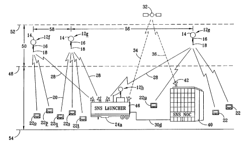
Figure 1 depicts a schematic view of a portion of a constellation and
communications network system 10 according to the present invention in which
airborne
platforms 12(a)-(g) have reached a desired altitude within a range of
altitudes, such as
in the stratosphere. Also depicted is an airborne plattorm 12(h) in the
process of
ascending to a desired altitude. Each airborne platform comprises a lighter-
than-air gas
enclosure 14(a)-(h), a platform control and communicator device 16(a)-(b) and
an
antennae 18(a)-(b). Communication signals between platforms and ground
terminals are
schematically represented at 20(a)-(u) correspondingly communicating with a
plurality of
ground communication devices such as radio signal receivers, transceivers,
transmitters,
or pagers 22(a)-(u). There are a plurality of launch and tracking terminals
24(a >-~(d), eact;
having a plurality of tracking antennas 26(a)-(g). Ground terminals relay
message and
control data between the SNS platforms and the NOC. Preferably the ground
terminals
can operate unattended requiring only electrical power and communications
signals. The
ground terminals consist of a set of transmitters and receivers and their
controller,
tracking antennas and a tracking controller, redundant communications links to
the NOC
and backup power supply. To accommodate the potentiality for several platforms
within
range at any given time four to six separate transmitters, receivers and
tracking antennas
are currently contemplated. Glenayre offers appropriate commercially available
transmitters, transmitter controllers and receivers for the SNS ground
terminals although
some modifications will be required. The tracking antennas 26 are
schematically shown
in communication with the various platforms through signals 28(a)-(g). A
ground
communication network 30, having interconnecting segments 30(a)-(d) are
depicted
communicating between the launch and tracking stations 24(a)-(d) and a network
-17-
SUBSTITUTE SHEET ~RU~E 26~
CA 02377958 2001-12-28
WO 01/01710 PCT/US00/15607
operations center 40. The network operations center 40 may also communicate
with a
plurality of launch and tracking terminals 24 through an orbiting satellite 32
and launch
site satellite antennas 38(a)-(b) and network operation center satellite
antenna 42. For
purposes of illustration, launch and tracking terminal 24(c) is co-located
with an airborne
platform launcher 44 similar to or the same as the National Weather Service
balloon
launcher. One aspect of the invention also contemplates a mobile launcher and
tracking
terminal 46, as for example a self-contained unit mounted on a truck trailer.
The mobile
launcher can be transported to a desired launch site, parked there and
additional SNS
platforms can be launched. The tracking and communications terminals 24 can be
connected to the network via ground links 30(c) and 30(d), as well as to other
launch
stations and to the network operations center 40. The mobile launcher and
terminal may
be moved periodically from one location to another location to launch and/or
track
additional SNS communications platforms 12 as needed to fill in coverage gaps
as they
might arise due to weather conditions.
Figure 2 is an enlarged schematic depiction of the mobile SNS launcher 46 of
Figure 1 shown schematically in relationship to platforms 12(f), 12(g) and
12(e) that form
a portion of the constellation of platforms. The mobile SNS launcher is in
communication
with the network operations center 40. Further depicted in Figure 2 is a range
of desired
altitudes 50 defined by a minimum desired altitude 48 and a maximum desired
altitude 52,
each altitude measured relative to sea level 54. In one preferred embodiment,
a
predetermined range of altitudes is defined by a minimum desired altitude of
about 60,000
ft. and a maximum desired altitude of about 140,000 ft. These altitudes
generally
correspond to the Earth's stratosphere or to a range of stratospheric
altitudes 50. Further
depicted in Figure 2 is a gap of coverage 56 between spaced-apart platforms
12(g) and
12(e) schematically represented as a spaced-apart distance 56 that is
significantly larger
than the desired spaced-apart distance 58 between platforms 12(f) and 12(g).
In a further
preferred embodiment, it is anticipated that platforms will be regulated to
float within a
predetermined altitude range of between about 70,000 ft. and 100,000 ft., will
have a
coverage radius measuring about 175 miles (280 km), will be above commercially
_18_
CA 02377958 2001-12-28
WO 01/01710 PCT/US00/15607
regulated airspace and will be below altitudes at which platform survival is
less certain.
When the distance between two adjacent platforms in any direction is greater
than about
one and one-half times the coverage radius, a gap in coverage can begin to
occur. In
such instances, either an additional SNS platform can be launched from a fixed
launch
site or a mobile launching unit 46 can be moved on the ground to a location
substantially
between the two spaced-apart platforms 12(g) and 12(e) so that an additional
supplemental platform 12(h) may be launched for rapid ascent to the desired
altitude
range 50. Computer modeling based upon the tracking of all the platforms 12 in
a
constellation 10 of airborne platforms can be used to predict the development
of
significant gaps 56 in coverage and to rapidly deploy mobile launching units
to fill the
gaps. In the event that a stationary launching and tracking terminal is
already in a
location for launching a supplemental SNS platform, no mobile unit would be
required.
Figure 3 schematically depicts a platform 12(i) migrating due to wind currents
to
a handoff position 12(ii) shown in dashed lines. At the handoff position, the
next
downwind ground terminal 24(e) takes over tracking and communication and
maintains
control as the platform moves through position 12(iii) and over terminal
24(e).
Figure 4 is a schematic depiction of inter-platform communications with
subsequent
transmission to ground terminals and to a network operation center (NOC).
Figure 5 is a schematic depiction of platform-to-space satellite
communications
links for providing the network interconnection with a network operation
center (NOC).
This is advantageous because this can reduce or eliminate the number of ground
terminals, as the platforms would directly communicate with the NOC through
satellite
links.
Figure 6 is a schematic depiction of a "hub and spoke" network communications
link topology. This is advantageous because it requires fewer physical
communications
-19-
CA 02377958 2001-12-28
WO 01/01710 PCT/US00/15607
lines and generally requires less expensive equipment than alternative network
topologies.
Figure 7 is a schematic depiction of a mesh network communications link
topology.
This is advantageous because a "mesh" topology provides multiple redundant
communications links to other parts of the network adding increased
reliability.
Figure 8 schematically depicts a contiguous geographic area 100, and in
particular
by way of example, a geographic area corresponding to the United States of
America.
Superimposed on the geographic area 100 are 70 selected standard launch sites
represented by "Xs" 101-105 (only a few examples are numbered). Further
schematically
depicted are coverage areas 201-205 (again only examples are numbered)
representing
the position and coverage of each of the platforms 101-105 as they reach a
desired
regulated altitude, preferably in the stratosphere. Each platform is very
small compared
to existing geosynchronous orbit satellites such that they have been referred
to and are
designed to float in a regulated altitude in the stratosphere such that they
have been
designated as "stratospheric nanosatellites" (SNS). The coverage areas 201-205
are
depicted in Figure 4 assuming a relatively vertical ascent from the launch
sites 101-105.
The coverage areas 201-205 will migrate over a period of time, due to wind and
weather
conditions in a particular locality. However, the ascent to the stratospheric
desired
altitudes normally takes from about one to two hours, such that the drift for
normal
airspeeds of less than about 10-20 mph and even passing through the jet stream
if
present will produce relatively small drifts of 10-80 miles in any direction
during the
ascent. Thus, relative to the approximately 175-mile (280 km), coverage radius
for a
circular coverage area having a diameter of about 350 miles (560 km), the
migration
during a short period of time with standard wind conditions of 10-40 miles,
indicates that
the launch site is a reasonable approximation for the initial high altitude
location at the
end of the ascent.
-20-
CA 02377958 2001-12-28
WO 01/01710 PCT/US00/15607
The platforms or balloons 12 are provided with altitude control mechanisms,
including both low density gas venting and high density ballast dropping
mechanisms,
allowing the balloon to be controlled to maintain a desired altitude within a
range of
desired altitudes. The altitudes may be maintained for between 12-24 hours
corresponding to the current NWS balloon launching schedule of two launches
per day.
If the NWS launching schedule is not used, the balloon altitudes may be
maintained for
over 100 hours depending on the lift gas, power, and ballast remaining on the
balloon 12.
In the case of NWS balloons, currently the balloons self-destruct from
overexpansion as
they reach and exceed altitudes of over 100,000 ft. and weather data is
gathered and
transmitted to the ground during the ascent. In the case of balloons acting as
carriers for
the communications platforms, the platforms will be maintained at an altitude
preferably
less than 140,000 ft. And more preferably less than about 100,000 ft. and will
continue
to migrate due to upper stratospheric wind conditions. The NOC may command SNS
platforms to rapid deflate or burst in the case of a balloon 12, when the
platform is no
longer needed, it falls below the 60,000 ft. and no ballast remains, it drifts
over an
undesired area, or it malfunctions. The platform may initiate this if any of
these conditions
are met and the platform has lost communication with the ground terminals.
Advantageously, the wind conditions will have been detected during the ascent
and will
continue to be monitored through the tracking by the ground stations. This
will facilitate
predicting the development of any gaps in coverage that might be expected, and
particularly the location of such gaps and the number of ground communication
devices
or pagers that might need to be serviced in the area of the gap.
Figure 9 is a schematic depiction of the geographic area 100 after a given
migration time period during which significant gaps may begin to occur. Mobile
units may
be positioned at temporary launch sites 171 and 172 for filling developing
gaps 56(b) and
56(c). Also, where a gap is predicted to develop in close proximity to a
standard launch
site, as, for example, at 105, an additional platform may be launched from
launch site 105
in advance of the normally regular launch time period. Thus, gap 56(c) may be
filled by
an additional launch. In a similar manner, regionally located mobile launch
sites may be
-21 -
CA 02377958 2001-12-28
WO 01/01710 PCT/US00/15607
employed to fill gaps as they arise. In the event that a pattern of gap
development is
detected, then additional permanent launch sites 173 and 174 may be added to
help
compensate for repeated developments of gaps 56(d) and 56(e), for example.
Temporary
launch sites may be moved seasonally to fill the gaps along the coast line
along the
direction the wind is blowing for the season, for example, the western coast
during the
winter season.
Figure 10 shows a schematic side elevation view of a platform 12 in an
embodiment in which the low density gas enclosure 70 is preferably a latex
balloon 70.
A Totex 1000 balloon filled with hydrogen, helium, natural gas, or another
suitable low
density gas or mixture and internally coated to reduce gas diffusion
adequately provides
lift for the SNS communications platform. The Totex balloon is released with a
diameter
of about five and one quarter feet and expands to about twenty-four feet
across at
140,000 feet altitude. It will be noted that other lighter-than-air
enclosures, such as blimps,
aerostats, zeppelins, airships, dirigibles, weather balloons, jimspheres, hot
air balloons,
sounding balloons or meteorological balloon might also be used in place of the
proposed
latex weather balloon 70 schematically depicted in Figure 10. Also, the
diameter of
balloon 70 in Figure 10 is not to scale and it is expected that a total
platform weight,
including the payload box 300, altitude control vent mechanism 72,
meteorological
package 82, antennae 76 and meteorological cable connection 84. Preferably the
cable
84 is a fiberoptic cable having a length of approximately 25 meters so that
the
meteorological data collection package 82 is sufficiently distanced from the
balloon 70 to
reduce to a minimum the effect of turbulence caused by the balloon on the
meteorological
data sensed by the meteorological package 82. The fiberoptic cable 84 is used
to
transmit the meteorological data from meteorological package 82 to the
communications
unit 74. Fiberoptic cable is used as wire could arc due to the high electric
field potential
when passing through thunderclouds.
There are numerous types of low density gas enclosure devices, and
particularly
balloons, that might be considered useful for the present invention. Among the
potentially
-22-
CA 02377958 2001-12-28
WO 01/01710 PCT/US00/15607
preferred types of balloons are rubber pressure balloons, zero pressure
balloons, internal
air bladder balloons, adjustable volume balloons and super pressure balloons.
Each type
of these balloons has different advantages and disadvantages and, for purposes
of the
present invention, it has been found that the rubber pressure balloon is most
preferred
and the zero pressure balloon is also considered a preferred alternative.
Advantageously,
such balloons 14 may be coated on a surface, preferably on the inside thereof
as
depicted schematically at 15 in figure 10, with a reduced permeability
material, such as
by fluid deposition of a sealer that remains flexible upon application.
The rubber pressure balloons have a stretchable rubber membrane containing the
lifting gas that allows the balloon to increase in size as the external air
pressure
decreases as the balloon rises. This is the most common type of weather
balloon and is
also consistent with party balloons. The primary advantage is the low cost and
common
accessibility so that high quality balloons of this type, such as weather
balloons, are
available at low cost. These balloons are somewhat fragile and they have
delicate
handling requirements and also low extended reliability. Further, the use of
such balloons
requires venting of the lifting gas to prevent bursting upon reaching maximum
volumes.
The zero pressure balloons consist of an initially loose bag, usually made
from a
plastic such as polyethylene or Mylar. As the external air pressure decreases,
the bag
increases in volume. Once the bag reaches its whole volume, gas must be vented
or the
balloon will burst as the bag material does not stretch. Although this type of
balloon may
be more reliable than the rubber balloons and provide less diffusion of the
lifting gas, it
is of a median cost, more costly than the rubber balloons, currently between
about four
to ten times more expensive. Thus, although the rubber balloon might be more
preferred
for purposes of low cost platforms, the zero pressure balloon also provides a
useful
enclosure for lifting the platform up and has certain advantages over the
rubber pressure
balloons.
-23-
CA 02377958 2001-12-28
WO 01/01710 PCT/US00/15607
Internal air bladder balloons consist of a flexible balloon containing air
enclosed in
a fixed volume balloon containing a lifting gas. Air is pumped into the inner-
flexible
balloon which compresses the lifting gas trapped in the fixed volume balloon,
thereby
decreasing the overall lift. Air is let out of the inner-flexible balloon to
increase lift. Blimps
adjust lift using this principle. This type of balloon has certain advantages
as there is no
lift gas lost when reducing lift and it is potentially more reliable than
rubber balloons,
however it is more costly due to extra balloon, pump and extra required power
for
operating the increase and decrease of lift mechanism.
Adjustable volume balloons consist of a fixed volume containing the lifting
gas and
a mechanical way of reducing the volume of the balloon. By decreasing the
volume, the
lifting gas is compressed and the lift decreases. The volume may be reduced
any number
of ways, including an adjustable line inside the balloon from the neck of the
balloon to the
top of the balloon. When the line is shortened, volume decreases. The lifting
gas is not
vented to reduce lift and it may be more reliable than rubber balloons.
However, it has
a significantly more costly due to the mechanical volume reducing mechanism
and further,
requires extra power for operation of such a mechanical volume-reducing
mechanism.
Super pressure balloons have a fixed volume. They are called super pressure
balloons because they do not expand to match the decreasing exterior pressure.
They
are built strong enough to hold the increased pressure. The balloons can
achieve
extremely long float lives because they do not need to vent gas to prevent
bursting and
they typically have very low membrane gas diffusion. This type of balloon is
the highest
cost, although one of the most reliable, with little loss of lifting gas. The
extreme high cost
and difficulty of manufacture and the lack of developed technology regarding
such
balloons, indicates that other alternatives are currently more attractive.
A signal transmission antenna 76 extends from the communications device 74
preferably vertically downward from the communications device 74 and
preferably a
collinear array with approximately a 6 degree downtilt configured to provide
even
-24-
CA 02377958 2001-12-28
WO 01/01710 PCT/US00/15607
transmission and reception coverage over the entire circular coverage area.
The
antennae 77 may advantageously be provided with a support loop 86 to
facilitate
stabilization between the antennae and the meteorological connection cable 84.
Also
depicted in Figure 10 is a balloon destruct mechanism 78 and a parachute 80
for recovery
of the communications device 74, when the balloon is destroyed by the
controlled destruct
mechanism 78 or otherwise by natural causes.
Figure 11 depicts a partial cross-sectional front view of one embodiment of a
communications device 74 according to the present invention. There is a
payload box
300, including an interior container 302 and exterior Styrofoam insulation 304
surrounding
the interior container 302. Within the container 302 is a circuit board 306 to
which various
electronic components are attached and interconnected to provide signal
communication
and remote control of the plattorm as desired. The electronics section consist
of the RF
section , antennas, GPS receiver, processor and power regulators. The RF
section is
based on the low cost transmitter and receiver section of current two-way
pagers. The
transmitter power is increased to approximately 7 watts. A single 900 MHZ
collinear
dipole array antenna serves both for transmit and receive functions.
Additional antennas
may be added for gateway RF links to the Ground Terminals if the additional
frequencies
become available. Possible frequencies include the 400 MHZ or the 1680 MHZ
band
assigned to meteorological instruments. If the SNS system also collects
weather data for
the NWS and this data is transmitted on the meteorological aids band, it may
be possible
to send additional gateway traffic with the meteorological data. A twelve
channel GPS
receiver in conjunction with the processor provides positional information to
both the NWS
during ascent and to the SNS NOC for the entire flight. The NOC uses the
information
to locate the SNS platforms, to determine coverage holes or gaps, and to make
rudimentary position adjustments by varying the altitude into favorable wind
speeds and
directions.
The embodiment depicted in Figure 11 and the side partial cross-section
thereof
as depicted in Figure 12 shows the power for the communications device 74
being
-25-
CA 02377958 2001-12-28
WO 01/01710 PCT/US00/15607
provided by a plurality of lightweight, high power batteries 308(a), (b), (c)
and (d). The
pla#orm may require between about three and eighteen watts of power depending
on the
message traffic and the platform configuration. Lithium sulfur dioxide (LiS02)
batteries are
cost and weight effective and have decent operating characteristics in a low
temperature
environment as found at high altitudes. The batteries are positioned at spaced-
apart
alternating positions so that maximum unit volume density is maintained below
established maximum unit volume density requirements for federal aviation
safety
standards. The low unit volume density and low total payload weight keeps the
launching of the balloons from being restricted by FAA regulations. For
example, to
facilitate keeping the platform safe as it ascends, A floating constellation
communications
system as in Claim 1 wherein said each of the plattorms will preferably be an
unmanned
free balloon and the payload box and its contents will preferably have a total
weight of
six pounds or less. The exterior surfaces will have predetermined areas and
the weight
to size ratio will desirably be maintained at no more than three ounces per
square inch
on any surface of the payload box and on the meteorological package where one
is
attached to the platform. The weight to size ratio is determined by dividing
the total
weight in ounces of any payload or package attached to the free balloon by the
area in
square inches of its smallest exterior surface of such payload or package.
In the platform payload box 300 there is a bottom opening 310 through which
the
meteorological connection cable 84 connects at a releasable cable connector
312 to the
circuit board 306 inside of the container 302. Also, antennae 76 is attached
at an
antennae connection 314 located in the bottom opening 310 so that signals may
be
received or transmitted through the antennae 76 to and from circuit board 306.
Meteorological data from fiberoptic cable 84 may be received and processed in
components of the circuit board 306 and transmitted to the ground terminal 24
through
antennae 76. To facilitate ease of detachment of the meteorological package
upon
inadvertent impact, the fiber optic cable will desirably separate from the
balloon upon an
impact of fifty pounds or less. Active antennae stabilizers 316 are provided
to reduce and
dampen movement of antennae 76 so that consistent signal reception and
transmission
-26-
CA 02377958 2001-12-28
WO 01/01710 PCT/US00/15607
is accomplished. To facilitate regulation of the altitude of the airborne
plattorm 12 and the
attached communications unit 74, the payload box 300 includes a ballast
storage
chamber 320 in which ballast 318 is carried. Ballast 318 is preferably easily
moveable
lead shot, metal BBs or spherical glass beads that may be controllably
released as with
a ballast drop gate, such as a shuttle, that moves alternatively between
opening into the
ballast chamber 320 and then to the ballast outlet orifice 324, such that the
ballast may
fall from the bottom opening 310 as schematically depicted at 326. For
convenience and
for avoiding power depletion during storage or transport, a manual circuit
activation switch
328 is provided.
At the top of the payload box 300 is a balloon connection spindle 330, having
a
distal neck top 332 over which the flexible balloon connection neck 334 is
attached. The
balloon connection neck is sized for fitting over the spindle and is stretched
and moved
down to a stop lip 336 so that it is secured in position with one or more
heavy rubber
bands 338. For convenience, a rubber band storage channel 340 is provided
below the
stop lip. A rubber band is stored and in position for securing a "fresh,"
lighter-than-air
enclosure or balloon 70. Preferably, balloon 70 will be filled with helium
(He), hydrogen
(H2) or natural gas through a light gas fill valve 344 that is preferably
positioned above a
rain hood 342 that shields the payload box and certain components thereof from
rain and
other precipitation. The light gas fill valve 344 provides for a convenient
connection to a
light gas supply tank, such as a helium or a hydrogen supply tank, so that an
expandable
balloon is attached at its neck 334 to the spindle 330 and fill gas can then
be supplied in
a desired amount into the attached enclosure or balloon. A gas pressure sensor
tube 346
communicates between the interior of the spindle to relay the internal balloon
gas
pressure sensor 348 connected to the electronics of the circuit board. A gas
temperature
sensor 350 is attached and is desirably positioned at or above the neck top
332. A
temperature sensor wire 352 communicates a signal representing the temperature
to
appropriate circuitry on the circuit board 306. An ambient air temperature
sensor 354 is
also desirably provided, as well as an ambient air pressure sensor 356, both
of which are
connected for communicating the sensed ambient air temperature and the sensed
-27-
CA 02377958 2001-12-28
WO 01/01710 PCT/US00/15607
ambient air pressure to the circuit board. A battery temperature sensor 358, a
payload
temperature sensor 360 and an attitude sensor 362 may all be connected to the
circuit
board 306 to desirably provide information and input for remote controlling
and for
maintaining the functions of the airborne platform 12 using the circuit 306.
The data
collected from the gas temperature sensor 350, the ambient air temperature
sensor 354,
the gas pressure sensor tube input 348, and the ambient air pressure sensor
356 is used,
in part, to determine if the balloon is nearing a burst condition. A heater
and cooler device
364 is attached to control the interior temperature of the payload box. As the
airborne
platform ascends into high altitudes, the ambient temperature drops
dramatically and the
interior of the box will desirably be heated by heat generated by the
batteries or,
alternatively, by the heater 364. If the heat from the batteries is
significant and is
combined with, for example, bright sunlight, the interior temperature might
increase above
desired operating temperatures, then the cooler portion of heater and cooler
device 364
may be activated to maintain a desired operating temperature range. The heater
and
cooler device may be a thermoelectric cell.
For purposes of regulating the altitude of the balloon and, in particular, to
avoid
continuous ascent above the desired maximum high altitude, a light gas relief
valve 366
is provided. A spring 368 keeps the relief valve 366 normally closed. An
actuator rod 369
is attached to the valve 366 and to a valve actuator wire 370, to open the
valve against
the spring loading. A Nickel-Titanium (NiTi) wire may be used as the actuator
wire 370.
Light gas relief valve 366 opens against the spring loading when a small
amount of
current is passed through the NiTi wire causing it to shrink or shorten a
predetermined
amount so that the relief valve is pulled open, thereby allowing lighter-than-
air gasses to
escape. The actuator rod may pass through the top of the container 302,
preferably
through a seal 371, so that the interior of the container is not directly
exposed to the
elements. The ballast shuttle gate 322 may similarly be activated with a
ballast drop
actuator wire 372, also made of Nickel-Titanium (NiTi). The active antenna
stabilizers 316
may similarly be comprised of NiTi wire.
-28-
CA 02377958 2001-12-28
WO 01/01710 PCT/US00/15607
A meteorological drop control wire 374 may also be NiTi and can be used to
disconnect the weather sonde after meteorological data is no longer being
obtained.
Typically, weather balloons burst after they pass approximately 100,000 feet.
Here, the
balloon will vent some of the light gas to hold at a stratospheric altitude
for the desired
period of time. The destruct mechanism 78 may be remotely activated with the
sharp end
378 of a pivotal destruct arm to cause the platform to fall. The destruct arm
376 is spring-
loaded for rapid rotation into contact with the exterior of the balloon when a
hold release
pin 386 is pulled from engagement in a hold/release groove 384. The release
pin 386
may advantageously be controlled with a control wire 388 also appropriately
activated
through the circuit board upon receipt of remote signals through the antennae
76 or from
the processor. Also provided inside of the platform is a GPS antennae 390
connected to
the circuit board for reception of position information from The GPS satellite
system to
facilitate tracking of the platform as it migrates and floats over the
contiguous geographic
area of coverage.
Figure 13 is a schematic side partial cross-section of an alternative
embodiment
of the platform according to the present invention in which the electrical
power source for
the communications circuit and controls is a fuel cell 400. Fuel cell 400 may
advantageously be a proton exchange membrane (PEM) fuel cell of the type that
uses
hydrogen and oxygen to provide electrical power. This type of system requires
a
hydrogen tube 402 connecting from the source of hydrogen, i.e., the lighter-
than-air
balloon 70 to the fuel cell 400. A hydrogen inlet 404 is provided with a
hydrogen circulator
406, which may simply be a fan 406. Thus, using the hydrogen tube, hydrogen
may be
extracted from the balloon and inlet into the fuel cell 400. Also, there is a
hydrogen outlet
408 that is recycled back to the balloon. A hydrogen tube pressure sensor 410
is
provided to appropriately monitor the hydrogen partial pressure at the fuel
cell. A fuel cell
of this type also requires an oxygen supply that may be provided by attaching
an oxygen
balloon 414 to an oxygen tube 412 so that the oxygen balloon is inside of the
hydrogen
balloon enclosure. The oxygen balloon is constructed to hold the oxygen at a
significant
internal pressure. This oxygen balloon 414 may be attached to tube 412 with a
rubber
-29-
CA 02377958 2001-12-28
WO 01/01710 PCT/US00/15607
band 416 and an oxygen pump 418 moves and further pressurizes oxygen from the
oxygen balloon 414 into the fuel cell through an oxygen inlet 420. Again, to
regulate the
process an oxygen pressure sensor 422 is provided. The fuel cell reaction
results in
water as a byproduct. The water is maintained in a liquid state by the heat
generated by
the fuel cell and is desirably drained before it can freeze at the high
altitudes at which the
platform operates.
Figure 14 is a schematic block diagram of the SNS platform hardware contained
within the payload box 300 and placed on or interconnected with circuit board
306. A
processor 430 receives electrical signal input and provides electrical signal
output,
interacting with a plurality of components for both controlling the flotation
altitude,
temperature, balloon destruction, ballast drop, etc. of the platform and also
for receiving,
processing and transmitting communication signals received and transmitted to
and from
ground stations, personal communications devices or other information
communications.
Initially, block 432 represents either the batteries 308 or the fuel cell 400.
Block 434
represents the on/off switch 328 to activate providing power to a power supply
regulation
circuit 436 with output available power 438. For clarity, individual power
connections to
various operational and control devices have not been shown in all instances.
Power is
provided to the supply voltage sensor at block 440 and current supply sensor
block 442,
which provide information to an analog to digital converter 444. The analog to
digital
converter also variously receives information from the payload and battery
fuel cell
temperature gauge at block 446, both gas and ambient air temperature readings
at block
448 and gas pressure at block 450. Additional analog informational signals are
generally
represented by block 452. Digitally converted information is variously
provided to and
received from flash memory at block 454 and random access memory (RAM) at
block
456. From A/D converter 444 and also from the flash memory 454 and from RAM
memory 456, the processor has access to all the various input control data.
During the
ascent of the SNS platform, the meteorological package represented by block
458
receives appropriate weather information including ambient temperature 460,
ambient
pressure at 462 and ambient humidity at 464. The antenna stabilization 316
represented
-30-
CA 02377958 2001-12-28
WO 01/01710 PCT/US00/15607
by block 496 may rely upon the attitude sensor information that is part of the
SNS
platform control system at 466 to stabilize the antenna 76. Information sensed
or
gathered by the meteorological package 458 is transmitted. For example, the
infrared
transceiver 468 through a fiberoptic cable at block 470 corresponding to the
physical
fiberoptic cable 84 and a processor infrared transceiver 472 by which serial
meteorological data is transferred to the processor 430 for appropriate
transmission to
ground terminals during the ascent of the SNS platform with the meteorological
package
458 attached. A GPS antennae block 474, corresponding to physical GPS antennae
390,
communicates through a GPS receiver 476, indicated as a serial port and
further
synchronized with a GPS clock or seconds tick at block 478. Thus, the position
at
particular times is provided to the processor. This positioning information is
coordinated
with the other meteorological input for determining wind speeds steering any
part of the
ascent, thereby corresponding those wind speeds to particular altitudes and
geographical
locations during the ascent.
Communications are controlled by processor430, preferably using both a 900 MHZ
transceiver and modem 480 and a Gateway transceiver and modem 482 signal to
and
from co-linear array antennae 484 are interfaced through a diplexer 486
control
information received at co-linear array antennae 484, therefore transferred
through the
diplexer and one of the appropriate frequency transceivers to the processor
430 with input
information from ground signals and also from input information from the
onboard sensors
as provided through A/D converter 444, the GPS position information from 476,
the GPS
time information 478 and the attitude sensor information 466, various
functions of the
SNS platform can be controlled. Including the gas vent at block 488
corresponding to the
gas vent actuator 370. Also the ballast drop is controlled at block 490
corresponding to
the physical ballast drop actuator 372. The meteorological package drop
controlled
schematically at block 492 corresponding to the package drop actuator 374. The
balloon
destruct control is depicted at block 494 corresponding to the destruct
actuator 376.
Antennae stabilization may be affected according to controls at block 496
corresponding
to the antennae stabilization mechanism 316. Payload temperature controls,
both heating
-31 -
CA 02377958 2001-12-28
WO 01/01710 PCT/US00/15607
and cooling, may be controlled at block 498 corresponding to heaters and
coolers 364.
Additional functions as may be additionally included, are provided with
controls at block
500.
Other alterations and modifications of the invention will likewise become
apparent
to those of ordinary skill in the art upon reading the present disclosure, and
it is intended
that the scope of the invention disclosed herein be limited only by the
broadest
interpretation of the appended claims to which the inventors are legally
entitled.
-32-