Note: Descriptions are shown in the official language in which they were submitted.
CA 02379167 2002-01-11
WO 01/05184 PCT/SEOO/01327
-1-
SELECTION OF LOCATION MEASUREMENT UNITS FOR
DETERMINING THE POSITION OF A MOBILE COMMUNICATION
STATION
FIELD OF THE INVENTION
The invention relates generally to locating the position of a mobile
communication unit in a wireless communication network and, more particularly,
to
the selection of location measurement units to make uplink signal
measurements.
BACKGROUND OF THE INVENTION
The ability to locate the position of a mobile communication unit operating in
a wireless communication system provides many well known advantages. Exemplary
uses of such position locating capability include security applications,
emergency
response applications, and travel guidance applications. Among several
possible
techniques for providing position locating capability, techniques that make
measurements on uplink signals from the mobile unit are attractive, because
they
normally do not require any changes to the mobile units.
One example of an uplink time of arrival approach will now be described with
respect to the Global System for Mobile Communication (GSM), which is
exemplary
of a wireless communication system in which uplink time of arrival techniques
are
applicable. When an external application (or the GSM network itself) decides
to
locate the position of a mobile unit (also referred to as mobile station MS),
a Mobile
Location Center forces (via a base station controller) the mobile unit to
perform a
conventional asynchronous handover, whereupon the mobile unit transmits up to
70
= 25 uplink access bursts, one burst per TDMA frame (i.e., one burst every 8
time slots).
The mobile unit transmits the access bursts in an attempt to comply with the
asynchronous handover command.
The Mobile Location Center (MLC) orders a number ofLocation Measurement
Units (LMUs) to capture the access bursts and measure the time of arrival oT
each
burst at each LMU. The LMUs then provide the MLC with their time of arrival
CA 02379167 2002-01-11
WO 01/05184 PCT/SEOO/01327
-2-
measurements and reliability estimates for these measurements. In order to
compute
the position of the mobile station, the MLC uses the time of arrival values
and
corresponding reliability parameters, the geographic location coordinates
ofthe LMUs,
and information regarding time differences among the respective internal time
bases
of the LMUs. For example, each LMU can be provided with an absolute time
reference (e.g., a Global Positioning System (GPS) clock), in which case the
LMUs
are all synchronized together, so that relative time differences among the
LMUs are
not a factor in the MLC's calculation of the position of the mobile station.
However, if the LMUs do not include an absolute time reference, then the
relative differences among their respective local time references can be
determined,
for example, by having each LMU measure the time of arrival of an uplink burst
from
a stationary reference mobile station positioned at a known location in the
network.
The time of arrival information for the reference mobile station is then
transmitted
from the LMUs to the MLC. The MLC can use these time of arrival measurements
to compute the relative differences in the timing references of the respective
LMUs,
also referred to as inter-LMU time differences (ILTDs).
Other conventional techniques are also available for determining the ILTDs.
Because the MLC knows the ILTDs (or alternatively knows that the LMUs are
all synchronized by a GPS system), it can calculate an estimate of the
position of a
given. mobile station from the time of arrival information provided by the
LMUs, using
conventional Time Difference of Arrival (TDOA) techniques.
The LMUs which should participate in a positioning measurement must be
configured before they can make TOA measurements. That is, the LMUs need
information about measurement starting time, measurement frequency, hopping
sequence and other parameters. The MLC conventionally provides the LMUs with
all
the information they need to make the TOA measurements. Therefore, the MLC
must
select the LMUs for a certain positioning measurement prior to the
measurement. To
position a certain mobile station, TOA measurements must be performed by at
least
3 LMUs. However, to avoid situations with poor measurement geometry and to
combat low SNR (signal-to-noise ratio), it may be preferable to use more
(e.g., -5-7)
LMUs for the TOA measurements. On the other hand, due to capacity constraints,
the
CA 02379167 2009-08-31
-3-
MLC should preferably select as few as possible LMUs for the TOA measurements.
The accuracy of a position fix depends on the accuracy of the individual TOA
measurements and on the measurement geometry.
Therefore, it is important to.select the LMUs such that (1) a good measurement
geometry is obtained and (2) the link from the MS to the selected.LMU has a
good
quality, e.g., a good SNR. The invention enables a mobile location node such
as an
MLC to select LMUs according to how well.the LMUs fulfill these requirements.
According to an aspect of the present invention there is provided a method of
selecting location measurement units for measuring an uplink signal
transmitted by a
mobile communication station operating in a wireless communication network in
order to
locate the position of the mobile communication station in the wireless
communication
network, the method comprising:
determining a geographic area of the network in which the mobile station is
possibly
located;
identifying a first position within the area;
determining relative positional relationships between the first position and a
plurality of
further positions respectively associated with a plurality of location
measurement units in
the network; and
choosing a subset of the plurality of location measurement units for measuring
the
uplink signal based on the relative positional relationships;
wherein said identifying step includes defining the first position to be
located
substantially centrally within the area, and including defining the further
positions based
on location coordinates and antenna normal vectors associated with the
respective
location measurement units.
According to another aspect of the present invention there is provided an
apparatus for selecting location measurement units for measuring an uplink
signal
received from a mobile communication station operating in a wireless
communication
network in order to locate the position of the mobile communication station in
the
wireless communication network, the apparatus comprising:
a first determiner having an input for receiving network information from
which can be
determined a geographic area of the network in which the mobile station is
possibly
located, said first determiner responsive to said network information for
determining said
CA 02379167 2009-08-31
-3a-
geographic area and identifying a first position therein; a second determiner
coupled to
said first determiner for receiving therefrom position information indicative
of said first
position, said second determiner having an input for receiving further network
information indicative of positioning of a plurality of location measurement
units in the
network, said second determiner responsive to said position information and
said further
network information for determining relative positional relationships between
said first
position and a plurality of further positions respectively associated with
said plurality of
location measurement units; and
a selector coupled to said second determiner for receiving therefrom
positional
relationship information indicative of said relative positional relationships,
said selector
responsive to said positional relationship information for selecting from said
plurality of
location measurement units a subset of location measurement units for
measuring the
uplink signal;
wherein said first determiner is operable to define said first position to be
located
substantially centrally within said area, and wherein said further network
information
includes location coordinates and antenna normal vectors associated with the
respective
location measurement units.
MR1EF DESCRIPTION OF THE DRAWINGS
FIGURE i illustrates an exemplary communication system according to the
invention.
FIGURES 2-5 illustrate exemplary geometric relationships utilized by the
present invention.
FIGURE 6 illustrates exemplary operations which can be performed by
embodiments of the mobile location node of FIGURE 1.
FIGURE 7 illustrates an exemplary portion of the mobile location node of
FIGURE 1 for performing the exemplary operations of FIGURE 6.
FIGURE 8 illustrates further exemplary geometric relationships utilized by the
invention.
FIGURE 9 illustrates further exemplary operations which can be performed by
embodiments of the mobile location node of FIGURE 1.
CA 02379167 2009-08-31
-3b-
FIGURE 10 illustrates an exemplary portion of the mobile location node of
FIGURE I for performing the exemplary operations of FIGURE 9.
FIGURE 11 illustrates further exemplary operations which can be performed
by embodiments of the mobile location node of FIGURE 1.
FIGURE 12 illustrates an exemplary portion of the mobile location node of
FIGURE 1 for performing the exemplary operations of FIGURE 11.
FIGURE 13 illustrates further exemplary operations which can be performed
by embodiments of the mobile location node of FIGURE 1.
FIGURE 14 illustrates an exemplary portion of the mobile location node-of
FIGURE '1 for performing the exemplary operations of FIGURE 13.
CA 02379167 2002-01-11
WO 01/05184 PCT/SE00/01327
-4-
FIGURE 15 illustrates further exemplary geometric relationships utilized by
the present invention.
DETAILED DESCRIPTION
FIGURE 1 illustrates pertinent portions of an exemplary communication
system in which the present invention is applicable. A mobile location node,
for
example a Mobile Location Center MLC in a GSM system, is coupled to a
plurality
of fixed-site radio transceivers 11 and a plurality of Location Measurement
Units
LMUs 13 by a mobile network structure 15. In cellular communication systems,
the
fixed-site transceivers 11 define one or more cells. One or more of the LMUs
can be
cosited with one or more of the fixed-site transceivers 11 as indicated
diagrammatically by the broken line connection therebetween. The mobile
network
structure can include one or more fixed-site transceiver controllers, such as
base
station controllers BSCs in GSM systems, and one or more mobile switching
exchanges, such as the mobile switching centers MSCs in GSM systems. The above-
described coupling between the mobile location center MLC and the fixed-site
transceivers 11 and LMUs 13 via the mobile network structure 15 is well known
in the
art.
The fixed-site transceivers 1l (e.g., GSM base stations BTS) communicate
with a plurality of mobile stations 17 via a conventional radio interface
illustrated
generally at 19. Such communications are well known in the art. Also, the LMUs
13
receive at 16 uplink radio communications from the mobile stations. The LMUs
perform conventional measurements relative to these uplink signals, such as
time of
arrival or angle of arrival measurements, and these measurements are used in
conventional fashion to locate the positions of the mobile stations. Such
operations
are well known in the art.
Also in the example of FIGURE 1, the mobile network structure 15 is coupled
to a fixed network 16 (e.g., a PSTN), thereby permitting mobile stations to
communicate with terminals in the fixed network via the fixed-site
transceivers 11, the
mobile network structure 15 and the fixed network 16.
As mentioned above, selection of LMUs is done before the uplink signal.
measurement is performed. Therefore, the MLC needs a rough estimate of a given
CA 02379167 2002-01-11
WO 01/05184 PCT/SEOO/01327
-5-
mobile station's position in order to select the LMUs that will make the
measurements
used to locate that mobile station's position. To obtain a first (rough)
position
estimate, the MLC is provided with the serving cell identity and the Timing
Advance
(TA) value, both of which are conventionally available to the MLC from the
network
structure 15.
Given the cell identity and the TA value of the serving cell, the MLC knows
that the mobile is between two circle sectors in a sectorized system, or
between two
circles in an omnicell system. More specifically, and referencing FIGURE 4,
the
mobile station is within area 41 in a sectorized system, or within an area
corresponding
to area 41 but extending through 360 in an omnicell system. The radial
dimension
of area 41 is typically on the order of 500 meters. Mathematically, this can
be
expressed as follows.
Consider the circle sector given by the radii dTA Ad (see area 41 of FIGURE
4), were dTA is the TA value expressed in range units (e.g., meters) and Ad is
the
uncertainty of the TA value due to quantization, noiselinterference,
multipath,
measurement error, etc. Parameterizing the angle v (see FIGURE 4) and the
radius
uncertainty Ad yields the possible location area t (v, Ad) of the MS:
Equation I
cosy - sine a
A(v'd} = _ b,~ + (dr,, + Ad) sinv cosv i .,,,
I ash
where -n/3 < v < r/3 (sectorized system), or 0 < v < 2n (omnicell system), -
400m < Ad
< 200m, b1 is the vector of the coordinates of the serving base station,
a..,,;,g is the
antenna normal vector of the.serving base station, and where I a;,,gi is
included to
normalize vector a.,õõ, FIGURES 2 and 3 illustrate examples of the
aforementioned
vectors relative to the origin of a geographical coordinate system such as a
Cartesian
coordinate system. FIGURE 2 illustrates b.,,,. g and a in a sectorized system,
and
= FIGURE 3 illustrates b in an omnicell system (wherein a is 0).
Equation 1 describes the possible location of the MS given the cell identity
and
the TA value. Equation 1 can be calculated by the MLC, and is the starting
point for
selecting the LMUs.
CA 02379167 2002-01-11
WO 01/05184 PCT/SEOOPl1327
-6-
The MLC can calculate the possible MS location area using Equation 1, and
can determine the middle (or center), *(0,0), of this MS location area. In the
case of
an omnicell system, *(0,0) = b, and in the case of a sectorized system, t(0,0)
defines the middle of the circle sector as shown in FIGURE 4. The MLC can, for
example, include a data base in which are stored network data such as the
coordinate
vectors and antenna normal vectors of all base stations and LMUs in the
network.
The MLC searches in its data base for those LMUs which are closest to the
middle of
the location area, *(0,0). This can be done using Equation 2 below.
Equation 2
10, d; = I 9(0,0) - (b; + a)
where b; and a, are the coordinate and antenna normal vectors, respectively,
of the
selected LMU i. Examples of the vectors b, and a; are illustrated generally in
FIGURE
5. Equation 2 represents the distance between points 51 and 52 in FIGURE 5,
point
51 corresponding to the middle of the possible location area, *(0,0), and
point 52 being
defined by vector (b; + a;) for the ith LMU. With this method, primarily
nearby LMUs
with antennas pointing towards the mobile station will be selected.
FIGURE 6 illustrates one example of the operations described above with
respect to Equations 1 and 2. At 61, the center (middle) point of the possible
mobile
station location area is determined, for example using *(0,0) in Equation 1.
At 62, a
2.0 desired number of LMUs positioned most favorably relative to the
calculated center
point are selected to perform the desired mobile station positioning
operation. For
example, those LMUs whose corresponding vectors (b; + a;) produce the smallest
values of d; in Equation 2 can be selected.
FIGURE 7 illustrates pertinent portions of an exemplary embodiment of the
mobile location node of FIGURE 1, which can perform the operations illustrated
in
FIGURE 6. A location area center determiner 71 uses available network data
(b,,
ate, dT,J to determine the center, *(0,0) of the possible location area using
Equation
1. A distance determiner 72 is coupled to the location area center determiner
71, and
receives therefrom information indicative of the location area center *(0,0).
The
distance determiner 72 also receives network data, b; and a;, for each
candidate LMU.
CA 02379167 2002-01-11
WO 01/05184 PCI'/SE00/01327
-7-
The distance determiner 72 uses the received network data and the location
area center
information in Equation 2 to calculate d, for each LMU;. A selector 73
receives
information indicative of the calculated distances d, and selects a desired
number of
= LMUs corresponding to the smallest distances d;.
In general, the cosine of the angle between two vectors is given by the scalar
product of the two vectors divided by the product of the magnitudes of the two
vectors.
Referring now to the example LMU illustrated in FIGURE 8, the angle 8 between
(1)
the antenna normal vector a; of the LMU and (2) the vector difference k(v,Ad) -
b;
between the LMU coordinate vector b; and a given mobile station position
vector
A(v,Ad), can be readily calculated as follows:
Equation 3
e = acos (*(v,Ad)-b) - a/ I *(v4d) b; I I a; I
The angle 0 can then be used in conjunction with an associated antenna gain
function & to calculate the antenna gain of the antenna used by the LMU of
FIGURE
8. Antenna gain functions & can be stored, for example, in the aforementioned
data base in the MLC, indexed against the corresponding types of antennas
having
those gain functions. Each LMU can, upon installation thereof in the network,
communicate its antenna type (or the antenna type of its cosited base station
if it shares
the base station antenna) to the MLC. The MLC can then access its data base
and use
the communicated antenna type to match the LMU to the corresponding antenna
gain
function. The antenna gain of the LMU for the angle 0 can then be determined
by
plugging 0 into the corresponding antenna gain function to produce g;(0).
This antenna gain can then be multiplied by a conventional path loss model
function of the distance between the mobile station and the LMU of FIGURE 8,
for
example the Okumura-Hats function,
f(d)=(
d)r.
0
= CA 02379167 2002-01-11
WO 01/05184 PCT/SEOO/01327
In exemplary formulations of this path loss model function, do = 1, and y =1,
2, 3,
4, or 5. Of course, the distance din this formula is simply the magnitude of
the vector
(*(v,Ad) - b) shown in FIGURE 8. The path loss model function can also be
stated in
decibels as f(d)[dB] =10-r-log10(.o). The Okumura-Hata function is described
in M.
Hata, "Empirical Formula for Propagation Loss in Land Mobile Radio Services",
IEEE
Transactions on Vehicular Technology, vol. 29, no. 3, Aug. 1980, pp. 217-325,
incorporated herein by reference.
Multiplying the aforementioned antenna gain function by the aforementioned
path loss function provides a mean path loss measure L1 for the LMU of FIGURE
8 as
follows:
Equation 4
g{e)= f(d).
Equation 4 can also be expressed in decibels as follows:
Equation 4A
L1(v,AJ[dB] = g,.(6)[d]3] + f(d)[dB]
Thus, for a given LMU;, a plurality of mean path loss measures L; can be
predicted for a corresponding plurality of possible locations, *(v,Ad), of the
mobile
station. Exemplary values which can be used to calculate 4 for each LMU
include,
v = -1x13, 0, 7r/3 for a sectorized system, v = 0, u/3, 27r/3, it, 4i13 and
5x/3 for an
omnicell system, and A. = -400m, 200m. Thus, in this example, for each LMU,
six
values of L1 would be calculated in a sectorized system, and twelve values of
L1 would
be calculated in an omnicell system.
FIGURE 9 illustrates an example implementation of the above-described
procedure. At 91, the mean path loss values LS are calculated for each
candidate LMU
according to Equations 1, 3 and 4. As one example, the candidate LMUs can be
selected using the exemplary procedure of FIGURE 6. At 92, the worst-case
(i.e.,
highest) mean path loss value L; for each LMU is selected. At 93, a desired
number
of LMUs having the best (i.e., lowest) worst-case values are selected to
perform the
desired positioning operation.
FIGURE 10 illustrates pertinent portions of an exemplary embodiment of the
mobile location node of FIGURE 1, which can perform the exemplary operations
of
CA 02379167 2002-01-11
WO 01/05184 PCT/SE00/01327
-9-
FIGURE 9. A path loss determiner 101 receives information indicative of
candidate
LMUs, for example, from selector 73 of FIGURE 7, and also receives network
data
defining: dTA; the coordinate vectors and antenna normal vectors of the
serving base
station and the candidate LMUs (i.e., b.,,;g, a..,,;.,, b; and a;); and the
antenna gain
functions g. for the candidate LMUs. The path loss determiner 101 calculates
mean
path loss values for each LMU according to Equations 1, 3 and 4. A selector
104,
including a worst-case filter 102 and a sorter 103, is coupled to path loss
determiner
101. The worst-case filter 102 receives the L; values calculated for each.LMU
and
determines the worst-case value for each LMU. These worst-case values are then
forwarded to the sorter 103 which sorts the worst-case values from best to
worst, and
selects a desired number of LMUs having the best of the worst-case values.
It is well known that the accuracy of a positioning system based on range
measurements such as TOA (Time of Arrival) or TDOA (Time Difference of
Arrival)
is heavily dependent on the relative geometry of the receiver (LMU) stations.
Positioning accuracy can be estimated as the ranging accuracy multiplied by a
dilution
factor, GDOP = Geometric Dilution of Precision. The GDOP is conventionally
defined as:
(Equation 5)
GDOP = trace (Q)
where Q is the covariance matrix of the position estimate f:
(Equation 6)
Q = E{(4-E{*})(*-E{f})T}
and E() denotes the statistical expectation. Using a weighted least squares
approach
to estimate the mobile position *, the covariance matrix Q is conventionally
given by:
Equation 7
Q=(GTR" G)''
where T denotes transpose. Without loss of generality, it can be assumed that
the
mobile station lies on a two dimensional x-y plane.
The position of the MS is defined as:
CA 02379167 2002-01-11
WO 01/05184 PCT/SEOO/01327
-10-
Equation 8
*(v,d) _ (* 9')=
The LMU coordinates can be expressed as b; = (x1, y1) for i = 1,...N.
The squared distance between the (assumed) mobile station position * and the
LMUs is r12 = (x1-*)2 + (y1- g)2 for i=l,..N.
In the exemplary case of a TDOA (Time Difference of Arrival) positioning
system, matrix G is conventionally given by
Equation 9
(xl -x')/r1-(x2 -xi/r2 (y, Yl/r1 -(Y2 Y)/r2
G = (xl X)/r, -(x3 z)/r3 (Yl Y)/r, -(Y, Y)/r3
(x, x)/r. -(xN-x)/rN (Y. Y)/r, -(Y",-Y-)/rN
and the R matrix is given by
Equation 10
R=HR0HT
where H is an (N-1) x N matrix
Equation 11
-1 1 0 0 ... 0
-1 0 1 0 ... 0
H
......... 0
-1 ... 1
and matrix R0 is given by
Equation 12
CA 02379167 2002-01-11
WO 01/05184 PCT/SE00/01327
-11-
a1 0 0 0
0 a2 0 0
Ro =
0 0 ... 0
0 0 0 aN
where each a; i=1,...,N is the uncertainty (quality) of the TOA measurement
provided
by a respective one of N LMUs.
In case of a TOA (Time of Arrival) or AOA (Angle of Arrival) positioning
system, G and R are described in: W.H. Foy, "Position-Location Solutions by
Taylor-
Series Estimation", IEEE Transactions on Aerospace and Electronic Systems,
Vol.
AES-12, no. 2, March 1976, pp. 187-194, incorporated herein by reference; and
D. J.
Torrieri, "Statistical Theory of Passive Location Systems", IEEE Transactions
on
Aerospace and Electronic Systems, Vol. AES-20, no. 2, March 1984, pp. 183-198,
incorporated herein by reference.
All of the information needed to determine the covariance matrix Q, and thus
the GDOP value, is available except for the a; values needed to complete the
matrix
R0. As mentioned above, these values are the uncertainties of the TOA
measurements
performed by the respective LMUs. These uncertainties of course are not known
before the LMUs actually perform their measurements. Accordingly, one
embodiment
of the present invention uses Equation 4 above to estimate these uncertainty
values,
that is, the invention assumes a; L;(v, Ad). In other words, if the mean path
loss L4 is
high, it can be assumed that there will be a high TOA estimation uncertainty,
whereas
if the mean path loss L; is low, it can be assumed that there is a low TOA
estimation
uncertainty.
Accordingly, for a given group of LMUs, a plurality of GDOP values can be
calculated (according to Equations 1, 3-5 and 7-12), each GDOP value
corresponding,
for example, to one of the possible mobile station locations described above
(6 for
sectorized systems, 12 for omnicell systems). For that group of LMUs, the
worst-case
(i.e., highest) value of all calculated GDOP values can be determined, and
then the
CA 02379167 2002-01-11
WO 01/05184 PGT/SEOOIO1327
-12-
GDOP calculation process can be repeated as described above but for different
groups
of LMUs. After the worst-case GDOP value has been determined for each group of
LMUs, the group of LMUs having the best (i.e., lowest) worst-case GDOP value
can
be selected to execute the desired mobile station positioning operation.
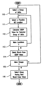
FIGURE 11 illustrates an example of the above-described use ofGDOP values
to select LMUs. At 110, a group of LMUs is selected. For example, a group
ofLMUs
can be selected from a set of candidate LMUs produced using the exemplary
operations of either of FIGURES 6 or 9. Thereafter at 111, a possible mobile
station
location is selected. At 112, a GDOP value for the group of LMUs is calculated
for
that particular possible mobile station location. The operations at 111 and
112 are
repeated until it is determined at 113 that all desired mobile station
location
possibilities have been considered. Thereafter, at 114, the worst-case GDOP
value of
all of the GDOP values calculated for the selected group of LMUs is selected.
Thereafter, the operations at 110-114 are repeated until it is determined at
115 that all
desired groups of LMUs have been considered. Thereafter at 116, the group of
LMUs
having the best worst-case GDOP value is selected to perform the desired
mobile
station positioning operation.
FIGURE 12 illustrates pertinent portions of an exemplary embodiment of the
mobile location node of FIGURE 1, which can perform the exemplary operations
illustrated in FIGURE 11. A combination generator 121 receives information
indicative of candidate LMUs, for example, from selector 104 of FIGURE 10 or
selector 73 of FIGURE 7. The combination generator generates various
combinations
of the candidate LMUs, which combinations define the groups of LMUs for which
GDOP values will be estimated. A GDOP determiner 125 receives from the
combination generator information indicative of the LMU groups. The GDOP
determiner 125 also receives network data defining dTA and the coordinate
vectors and
antenna normal vectors of the serving base station and the candidate LMUs. The
GDOP determiner can then use Equations 1, 3-5 and 7-12 to calculate the
estimated
GDOP values for each group of LMUs. A selector 122, including a worst-case
filter
126 and a sorter 128, is coupled to the GDOP determiner 125. The worst-case
filter
126 receives the GDOP values for each group of LMUs and determines the worst-
case
CA 02379167 2002-01-11
WO 01/05184 PCT/SE00/01327
-13-
value for that group. The sorter 128 receives the worst-case GDOP values of
the
respective groups, sorts them to determine the best worst-case GDOP value, and
selects the corresponding group of LMUs having the best worst-case value.
In another embodiment, the mobile location node of FIGURE 1 can send to all
of the candidate LMUs of FIGURE 12 a conventional measurement command. Each
of the candidate LMUs will respond in conventional fashion by, for example,
providing to the mobile location node conventional TOA information and the
corresponding uncertainty parameter a;. These uncertainty parameters (shown in
broken line in Figure 12) are then used directlybythe GDOP estimator to
calculate the
GDOP values without calculating L, values in Equation 4.
The mobile location node can in some cases use conventional measurement
reports provided by the mobile stations. The measurement report from the
mobile
station can be forwarded from the associated fixed-site transceiver 11 to the
mobile
location node. For example, in GSM systems, such measurement reports contain
measured signal strength C + I + N (carrier + interference + noise) on BCCH
(broadcast control channel) frequencies of neighboring base stations for which
the
BSIC (base station identity code) has been decoded successfully. If the BSIC
of a
certain base station has been successfully decoded by the mobile station, it
should be
likely that an LMU cosited with that base station is suitable to use for an
uplink
measurement. Therefore, the mobile location node can use this additional
information
for LMU selection. Those LMUs cosited with base stations whose BSIC has been
decoded successfully can be given priority over other LMU candidates.
FIGURE 13 illustrates exemplary operations which can be performed
according to the invention in response to measurement reports received from
the
mobile stations. At 131, information indicative of the selected LMUs is
received, for
example the LMUs selected by the exemplary operations illustrated in FIGURES
6,
9 or 11. At 132, the LMU selections are selectively changed in response to the
measurement reports. For example, the group of selected LMUs can be modified
to
ensure that it includes all LMUs that are cosited with base stations whose
BSICs have
been successfully decoded. In such instances, the most poorly qualified of the
LMUs
CA 02379167 2002-01-11
WO 01/05184 PCT/SE00/01327
-14-
received at 131 can be replaced by LMUs cosited with base stations whose BSICs
have
been successfully decoded.
FIGURE 14 illustrates pertinent portions of an exemplary embodiment of the
mobile location node of FIGURE 1, which can perform the exemplary operations
illustrated in FIGURE 13. A modifier 141 receives information indicative of
the
selected LMUs, for example, from selector 73 of FIGURE 7, selector 104 of
FIGURE
or selector 122 of FIGURE 12. The modifier 141 also receives measurement
reports from the mobile stations, and selectively modifies the group
ofselected LMUs
as described above in response to the received measurement reports.
10 When using the inventive techniques described above, situations can occur
when two LMUs are assigned the same value of their cost function, e.g., the
same d,
value in Equation 2 or the same worst-case L; value from Equation 4. In this
case, the
mobile location node can select both LMUs to perform measurements, or randomly
select one of them. As FIGURE IS suggests, it is sometimes advantageous to
select
both LMUs, and afterwards either combine their results (e.g., by averaging) or
choose
the one with e.g., the highest SNR. As shown in FIGURE 15, cosited LMUI and
LMU2 will yield the same distance d; in Equation 2, but LMUI will be
preferable if
the MS is located in the upper portion 151 of the possible location area 150.
It will be evident to workers in the art that the above-described invention
can
be readily implemented by, for example, suitable modifications in software,
hardware
or both, in a conventional mobile location node such as a Mobile Location
Center
MLC in GSM.
Although exemplary embodiments of the. present invention have been
described above in detail, this does not limit the scope of the invention,
which can be
practiced in a variety of embodiments.
CA 02379167 2002-01-11
WO 01/05184 PCT/SEOO/01327
-1-
SELECTION OF LOCATION MEASUREMENT UNITS FOR
DETERMINING THE POSITION OF A MOBILE COMMUNICATION
STATION
FIELD OF THE INVENTION
The invention relates generally to locating the position of a mobile
communication unit in a wireless communication network and, more particularly,
to
the selection of location measurement units to make uplink signal
measurements.
BACKGROUND OF THE INVENTION
The ability to locate the position of a mobile communication unit operating in
a wireless communication system provides many well known advantages. Exemplary
uses of such position locating capability include security applications,
emergency
response applications, and travel guidance applications. Among several
possible
techniques for providing position locating capability, techniques that make
measurements on uplink signals from the mobile unit are attractive, because
they
normally do not require any changes to the mobile units.
One example of an uplink time of arrival approach will now be described with
respect to the Global System for Mobile Communication (GSM), which is
exemplary
of a wireless communication system in which uplink time of arrival techniques
are
applicable. When an external application (or the GSM network itself) decides
to
locate the position of a mobile unit (also referred to as mobile station MS),
a Mobile
Location Center forces (via a base station controller) the mobile unit to
perform a
conventional asynchronous handover, whereupon the mobile unit transmits up to
70
= 25 uplink access bursts, one burst per TDMA frame (i.e., one burst every 8
time slots).
The mobile unit transmits the access bursts in an attempt to comply with the
asynchronous handover command.
The Mobile Location Center (MLC) orders a number ofLocation Measurement
Units (LMUs) to capture the access bursts and measure the time of arrival oT
each
burst at each LMU. The LMUs then provide the MLC with their time of arrival
CA 02379167 2002-01-11
WO 01/05184 PCT/SEOO/01327
-2-
measurements and reliability estimates for these measurements. In order to
compute
the position of the mobile station, the MLC uses the time of arrival values
and
corresponding reliability parameters, the geographic location coordinates
ofthe LMUs,
and information regarding time differences among the respective internal time
bases
of the LMUs. For example, each LMU can be provided with an absolute time
reference (e.g., a Global Positioning System (GPS) clock), in which case the
LMUs
are all synchronized together, so that relative time differences among the
LMUs are
not a factor in the MLC's calculation of the position of the mobile station.
However, if the LMUs do not include an absolute time reference, then the
relative differences among their respective local time references can be
determined,
for example, by having each LMU measure the time of arrival of an uplink burst
from
a stationary reference mobile station positioned at a known location in the
network.
The time of arrival information for the reference mobile station is then
transmitted
from the LMUs to the MLC. The MLC can use these time of arrival measurements
to compute the relative differences in the timing references of the respective
LMUs,
also referred to as inter-LMU time differences (ILTDs).
Other conventional techniques are also available for determining the ILTDs.
Because the MLC knows the ILTDs (or alternatively knows that the LMUs are
all synchronized by a GPS system), it can calculate an estimate of the
position of a
given. mobile station from the time of arrival information provided by the
LMUs, using
conventional Time Difference of Arrival (TDOA) techniques.
The LMUs which should participate in a positioning measurement must be
configured before they can make TOA measurements. That is, the LMUs need
information about measurement starting time, measurement frequency, hopping
sequence and other parameters. The MLC conventionally provides the LMUs with
all
the information they need to make the TOA measurements. Therefore, the MLC
must
select the LMUs for a certain positioning measurement prior to the
measurement. To
position a certain mobile station, TOA measurements must be performed by at
least
3 LMUs. However, to avoid situations with poor measurement geometry and to
combat low SNR (signal-to-noise ratio), it may be preferable to use more
(e.g., -5-7)
LMUs for the TOA measurements. On the other hand, due to capacity constraints,
the
CA 02379167 2005-05-04
-3-
MLC should preferably select as few as possible LMUs for the TOA measurements.
The accuracy of a position fix depends on the accuracy of the individual TOA
measurements and on the measurement geometry.
Therefore, it is important to select the LMUs such that (1) a good measurement
geometry is obtained and (2) the link from the MS to the selected LMU has a
good
quality, e.g., a good SNR. The invention enables a mobile location node such
as an
MLC to select LMUs according to how well the LMUs fulfill these requirements.
According to an aspect of the present invention there is provided a method of
selecting location measurement units for measuring an uplink signal
transmitted by a
mobile communication station operating in a wireless communication network in
order
to locate the position of the mobile communication station in the wireless
communication network, the method comprising determining a geographic area of
the
network in which the mobile station is possibly located, identifying a first
position
within the area, determining relative positional relationships between the
first position
and a plurality of further positions respectively associated with a plurality
of location
measurement units in the network, and choosing a subset of the plurality of
location
measurement units for measuring the uplink signal based on the relative
positional
relationships.
According to another aspect of the present invention there is provided a
method
of selecting location measurement units for measuring an uplink signal
transmitted by
a mobile communication station operating in a wireless communication network
in
order to locate the position of the mobile communication station in the
wireless
communication network, the method comprising identifying a possible position
of the
mobile station in the network, predicting for each of a plurality of location
measurement units in the network a respective path loss measure relative to
the
possible position of the mobile station, and choosing a subset of the
plurality of
location measurement units to measure the uplink signal based on the path loss
measures.
According to a further aspect of the present invention there is provided a
method of selecting location measurement units for measuring an uplink signal
received from a mobile communication station operating in a wireless
communication
network in order to locate the position of the mobile communication station in
the
CA 02379167 2005-05-04
-3a-
wireless communication network, the method comprising identifying a possible
position of the mobile station in the network, determining for each of a
plurality of
groups of location measurement units in the network a geometric dilution of
precision
(GDOP) value with respect to the possible position of the mobile station, and
selecting
one of the groups of location measurement units based on the GDOP values.
According to a further aspect of the present invention there is provided an
apparatus for selecting location measurement units for measuring an uplink
signal
received from a mobile communication station operating in a wireless
communication
network in order to locate the position of the mobile communication station in
the
wireless communication network, the apparatus comprising a first determiner
having
an input for receiving network information from which can be determined a
geographic
area of the network in which the mobile station is possibly located, the first
determiner
responsive to the network information for determining the geographic area and
identifying a first position therein, a second determiner coupled to the first
determiner
for receiving therefrom position information indicative of the first position,
the second
determiner having an input for receiving further network information
indicative of
positioning of a plurality of location measurement units in the network, the
second
determiner responsive to the position information and the further network
information
for determining relative positional relationships between the first position
and a
plurality of further positions respectively associated with the plurality of
location
measurement units, and a selector coupled to the second determiner for
receiving
therefrom positional relationship information indicative of the relative
positional
relationships, the selector responsive to the positional relationship
information for
selecting from the plurality of location measurement units a subset of
location
measurement units for measuring the uplink signal.
According to a further aspect of the present invention there is provided an
apparatus for selecting location measurement units for measuring an uplink
signal
received from a mobile communication station operating in a wireless
communication
network in order to locate the position of the mobile communication station in
the
wireless communication network, the apparatus comprising a path loss
determiner
having an input for receiving network information from which can be determined
a
possible position of the mobile station in the network, the network
information further
indicative of positioning of a plurality of location measurement units in the
network,
CA 02379167 2005-05-04
-3b-
the path loss determiner responsive to the network information for identifying
a
possible position of the mobile station in the network, the path loss
determiner further
responsive to the network information for predicting, for each of the
plurality of
location measurement units, a respective path loss measure relative to the
possible
position of the mobile station, and a selector coupled to the path loss
determiner for
receiving therefrom path loss information indicative of the path loss
measures, the
selector responsive to the path loss information for selecting from the
plurality of
location measurement units a subset of location measurement units to measure
the
uplink signal.
According to a further aspect of the present invention there is provided an
apparatus for selecting location measurement units for measuring an uplink
signal
received from a mobile communication station operating in a wireless
communication
network in order to locate the position of the mobile communication station in
the
wireless communication network, the apparatus comprising a determiner for
receiving
network information from which can be determined a possible position of the
mobile
station in the network, the network information further indicative of
positioning of a
plurality of location measurement units in the network, the determiner
responsive to
the network information for identifying a possible position of the mobile
station in the
network, and the determiner further responsive to the network information for
determining, for each of a plurality of groups of the location measurement
units, a
geometric dilution of precision (GDOP) value with respect to the possible
position of
the mobile station, and a selector coupled to the determiner for receiving
therefrom
GDOP information indicative of the GDOP values, the selector responsive to the
GDOP information for selecting one of the groups of location measurement units
to
measure the uplink signal.
BRIEF DESCRIPTION OF THE DRAWINGS
FIGURE 1 illustrates an exemplary communication system according to the
invention.
FIGURES 2-5 illustrate exemplary geometric relationships utilized by the
present invention.
FIGURE 6 illustrates exemplary operations which can be performed by
embodiments of the mobile location node of FIGURE 1.
FIGURE 7 illustrates an exemplary portion of the mobile location node of
FIGURE 1 for performing the exemplary operations of FIGURE 6.
CA 02379167 2005-06-09
-3 c-
FIGURE 8 illustrates further exemplary geometric relationships utilized by the
invention-
FIGURE 9 illustrates further exemplary operations which canbe performed by
embodiments of the mobile location node of FIGURE 1.
FIGURE 10 illustrates an exemplary portion of the mobile location node of
FIGURE 1 for performing the exemplary operations of FIGURE 9.
FIGURE 11 illustrates further exemplary operations which can be performed
by embodiments of the mobile location node of FIGURE 1.
FIGURE 12 illustrates an exemplary portion of the mobile location node of
_
FIGURE I for performing the exemplary operations of FIGURE 11
FIGURE 13 illustrates fiuther exemplary operations which can be performed
by embodiments of the mobile location node of FIGURE 1.
FIGURE 14 illustrates an exemplary portion of the mobile location node-of
FIGURE 1 for performing the exemplary operations of FIGURE 13.
CA 02379167 2002-01-11
WO 01/05184 PCT/SE00/01327
-4-
FIGURE 15 illustrates further exemplary geometric relationships utilized by
the present invention.
DETAILED DESCRIPTION
FIGURE 1 illustrates pertinent portions of an exemplary communication
system in which the present invention is applicable. A mobile location node,
for
example a Mobile Location Center MLC in a GSM system, is coupled to a
plurality
of fixed-site radio transceivers 11 and a plurality of Location Measurement
Units
LMUs 13 by a mobile network structure 15. In cellular communication systems,
the
fixed-site transceivers 11 define one or more cells. One or more of the LMUs
can be
cosited with one or more of the fixed-site transceivers 11 as indicated
diagrammatically by the broken line connection therebetween. The mobile
network
structure can include one or more fixed-site transceiver controllers, such as
base
station controllers BSCs in GSM systems, and one or more mobile switching
exchanges, such as the mobile switching centers MSCs in GSM systems. The above-
described coupling between the mobile location center MLC and the fixed-site
transceivers 11 and LMUs 13 via the mobile network structure 15 is well known
in the
art.
The fixed-site transceivers 1l (e.g., GSM base stations BTS) communicate
with a plurality of mobile stations 17 via a conventional radio interface
illustrated
generally at 19. Such communications are well known in the art. Also, the LMUs
13
receive at 16 uplink radio communications from the mobile stations. The LMUs
perform conventional measurements relative to these uplink signals, such as
time of
arrival or angle of arrival measurements, and these measurements are used in
conventional fashion to locate the positions of the mobile stations. Such
operations
are well known in the art.
Also in the example of FIGURE 1, the mobile network structure 15 is coupled
to a fixed network 16 (e.g., a PSTN), thereby permitting mobile stations to
communicate with terminals in the fixed network via the fixed-site
transceivers 11, the
mobile network structure 15 and the fixed network 16.
As mentioned above, selection of LMUs is done before the uplink signal.
measurement is performed. Therefore, the MLC needs a rough estimate of a given
CA 02379167 2002-01-11
WO 01/05184 PCT/SEOO/01327
-5-
mobile station's position in order to select the LMUs that will make the
measurements
used to locate that mobile station's position. To obtain a first (rough)
position
estimate, the MLC is provided with the serving cell identity and the Timing
Advance
(TA) value, both of which are conventionally available to the MLC from the
network
structure 15.
Given the cell identity and the TA value of the serving cell, the MLC knows
that the mobile is between two circle sectors in a sectorized system, or
between two
circles in an omnicell system. More specifically, and referencing FIGURE 4,
the
mobile station is within area 41 in a sectorized system, or within an area
corresponding
to area 41 but extending through 360 in an omnicell system. The radial
dimension
of area 41 is typically on the order of 500 meters. Mathematically, this can
be
expressed as follows.
Consider the circle sector given by the radii dTA Ad (see area 41 of FIGURE
4), were dTA is the TA value expressed in range units (e.g., meters) and Ad is
the
uncertainty of the TA value due to quantization, noiselinterference,
multipath,
measurement error, etc. Parameterizing the angle v (see FIGURE 4) and the
radius
uncertainty Ad yields the possible location area t (v, Ad) of the MS:
Equation I
cosy - sine a
A(v'd} = _ b,~ + (dr,, + Ad) sinv cosv i .,,,
I ash
where -n/3 < v < r/3 (sectorized system), or 0 < v < 2n (omnicell system), -
400m < Ad
< 200m, b1 is the vector of the coordinates of the serving base station,
a..,,;,g is the
antenna normal vector of the.serving base station, and where I a;,,gi is
included to
normalize vector a.,õõ, FIGURES 2 and 3 illustrate examples of the
aforementioned
vectors relative to the origin of a geographical coordinate system such as a
Cartesian
coordinate system. FIGURE 2 illustrates b.,,,. g and a in a sectorized system,
and
= FIGURE 3 illustrates b in an omnicell system (wherein a is 0).
Equation 1 describes the possible location of the MS given the cell identity
and
the TA value. Equation 1 can be calculated by the MLC, and is the starting
point for
selecting the LMUs.
CA 02379167 2002-01-11
WO 01/05184 PCT/SEOOPl1327
-6-
The MLC can calculate the possible MS location area using Equation 1, and
can determine the middle (or center), *(0,0), of this MS location area. In the
case of
an omnicell system, *(0,0) = b, and in the case of a sectorized system, t(0,0)
defines the middle of the circle sector as shown in FIGURE 4. The MLC can, for
example, include a data base in which are stored network data such as the
coordinate
vectors and antenna normal vectors of all base stations and LMUs in the
network.
The MLC searches in its data base for those LMUs which are closest to the
middle of
the location area, *(0,0). This can be done using Equation 2 below.
Equation 2
10, d; = I 9(0,0) - (b; + a)
where b; and a, are the coordinate and antenna normal vectors, respectively,
of the
selected LMU i. Examples of the vectors b, and a; are illustrated generally in
FIGURE
5. Equation 2 represents the distance between points 51 and 52 in FIGURE 5,
point
51 corresponding to the middle of the possible location area, *(0,0), and
point 52 being
defined by vector (b; + a;) for the ith LMU. With this method, primarily
nearby LMUs
with antennas pointing towards the mobile station will be selected.
FIGURE 6 illustrates one example of the operations described above with
respect to Equations 1 and 2. At 61, the center (middle) point of the possible
mobile
station location area is determined, for example using *(0,0) in Equation 1.
At 62, a
2.0 desired number of LMUs positioned most favorably relative to the
calculated center
point are selected to perform the desired mobile station positioning
operation. For
example, those LMUs whose corresponding vectors (b; + a;) produce the smallest
values of d; in Equation 2 can be selected.
FIGURE 7 illustrates pertinent portions of an exemplary embodiment of the
mobile location node of FIGURE 1, which can perform the operations illustrated
in
FIGURE 6. A location area center determiner 71 uses available network data
(b,,
ate, dT,J to determine the center, *(0,0) of the possible location area using
Equation
1. A distance determiner 72 is coupled to the location area center determiner
71, and
receives therefrom information indicative of the location area center *(0,0).
The
distance determiner 72 also receives network data, b; and a;, for each
candidate LMU.
CA 02379167 2002-01-11
WO 01/05184 PCI'/SE00/01327
-7-
The distance determiner 72 uses the received network data and the location
area center
information in Equation 2 to calculate d, for each LMU;. A selector 73
receives
information indicative of the calculated distances d, and selects a desired
number of
= LMUs corresponding to the smallest distances d;.
In general, the cosine of the angle between two vectors is given by the scalar
product of the two vectors divided by the product of the magnitudes of the two
vectors.
Referring now to the example LMU illustrated in FIGURE 8, the angle 8 between
(1)
the antenna normal vector a; of the LMU and (2) the vector difference k(v,Ad) -
b;
between the LMU coordinate vector b; and a given mobile station position
vector
A(v,Ad), can be readily calculated as follows:
Equation 3
e = acos (*(v,Ad)-b) - a/ I *(v4d) b; I I a; I
The angle 0 can then be used in conjunction with an associated antenna gain
function & to calculate the antenna gain of the antenna used by the LMU of
FIGURE
8. Antenna gain functions & can be stored, for example, in the aforementioned
data base in the MLC, indexed against the corresponding types of antennas
having
those gain functions. Each LMU can, upon installation thereof in the network,
communicate its antenna type (or the antenna type of its cosited base station
if it shares
the base station antenna) to the MLC. The MLC can then access its data base
and use
the communicated antenna type to match the LMU to the corresponding antenna
gain
function. The antenna gain of the LMU for the angle 0 can then be determined
by
plugging 0 into the corresponding antenna gain function to produce g;(0).
This antenna gain can then be multiplied by a conventional path loss model
function of the distance between the mobile station and the LMU of FIGURE 8,
for
example the Okumura-Hats function,
f(d)=(
d)r.
0
= CA 02379167 2002-01-11
WO 01/05184 PCT/SEOO/01327
In exemplary formulations of this path loss model function, do = 1, and y =1,
2, 3,
4, or 5. Of course, the distance din this formula is simply the magnitude of
the vector
(*(v,Ad) - b) shown in FIGURE 8. The path loss model function can also be
stated in
decibels as f(d)[dB] =10-r-log10(.o). The Okumura-Hata function is described
in M.
Hata, "Empirical Formula for Propagation Loss in Land Mobile Radio Services",
IEEE
Transactions on Vehicular Technology, vol. 29, no. 3, Aug. 1980, pp. 217-325,
incorporated herein by reference.
Multiplying the aforementioned antenna gain function by the aforementioned
path loss function provides a mean path loss measure L1 for the LMU of FIGURE
8 as
follows:
Equation 4
g{e)= f(d).
Equation 4 can also be expressed in decibels as follows:
Equation 4A
L1(v,AJ[dB] = g,.(6)[d]3] + f(d)[dB]
Thus, for a given LMU;, a plurality of mean path loss measures L; can be
predicted for a corresponding plurality of possible locations, *(v,Ad), of the
mobile
station. Exemplary values which can be used to calculate 4 for each LMU
include,
v = -1x13, 0, 7r/3 for a sectorized system, v = 0, u/3, 27r/3, it, 4i13 and
5x/3 for an
omnicell system, and A. = -400m, 200m. Thus, in this example, for each LMU,
six
values of L1 would be calculated in a sectorized system, and twelve values of
L1 would
be calculated in an omnicell system.
FIGURE 9 illustrates an example implementation of the above-described
procedure. At 91, the mean path loss values LS are calculated for each
candidate LMU
according to Equations 1, 3 and 4. As one example, the candidate LMUs can be
selected using the exemplary procedure of FIGURE 6. At 92, the worst-case
(i.e.,
highest) mean path loss value L; for each LMU is selected. At 93, a desired
number
of LMUs having the best (i.e., lowest) worst-case values are selected to
perform the
desired positioning operation.
FIGURE 10 illustrates pertinent portions of an exemplary embodiment of the
mobile location node of FIGURE 1, which can perform the exemplary operations
of
CA 02379167 2002-01-11
WO 01/05184 PCT/SE00/01327
-9-
FIGURE 9. A path loss determiner 101 receives information indicative of
candidate
LMUs, for example, from selector 73 of FIGURE 7, and also receives network
data
defining: dTA; the coordinate vectors and antenna normal vectors of the
serving base
station and the candidate LMUs (i.e., b.,,;g, a..,,;.,, b; and a;); and the
antenna gain
functions g. for the candidate LMUs. The path loss determiner 101 calculates
mean
path loss values for each LMU according to Equations 1, 3 and 4. A selector
104,
including a worst-case filter 102 and a sorter 103, is coupled to path loss
determiner
101. The worst-case filter 102 receives the L; values calculated for each.LMU
and
determines the worst-case value for each LMU. These worst-case values are then
forwarded to the sorter 103 which sorts the worst-case values from best to
worst, and
selects a desired number of LMUs having the best of the worst-case values.
It is well known that the accuracy of a positioning system based on range
measurements such as TOA (Time of Arrival) or TDOA (Time Difference of
Arrival)
is heavily dependent on the relative geometry of the receiver (LMU) stations.
Positioning accuracy can be estimated as the ranging accuracy multiplied by a
dilution
factor, GDOP = Geometric Dilution of Precision. The GDOP is conventionally
defined as:
(Equation 5)
GDOP = trace (Q)
where Q is the covariance matrix of the position estimate f:
(Equation 6)
Q = E{(4-E{*})(*-E{f})T}
and E() denotes the statistical expectation. Using a weighted least squares
approach
to estimate the mobile position *, the covariance matrix Q is conventionally
given by:
Equation 7
Q=(GTR" G)''
where T denotes transpose. Without loss of generality, it can be assumed that
the
mobile station lies on a two dimensional x-y plane.
The position of the MS is defined as:
CA 02379167 2002-01-11
WO 01/05184 PCT/SEOO/01327
-10-
Equation 8
*(v,d) _ (* 9')=
The LMU coordinates can be expressed as b; = (x1, y1) for i = 1,...N.
The squared distance between the (assumed) mobile station position * and the
LMUs is r12 = (x1-*)2 + (y1- g)2 for i=l,..N.
In the exemplary case of a TDOA (Time Difference of Arrival) positioning
system, matrix G is conventionally given by
Equation 9
(xl -x')/r1-(x2 -xi/r2 (y, Yl/r1 -(Y2 Y)/r2
G = (xl X)/r, -(x3 z)/r3 (Yl Y)/r, -(Y, Y)/r3
(x, x)/r. -(xN-x)/rN (Y. Y)/r, -(Y",-Y-)/rN
and the R matrix is given by
Equation 10
R=HR0HT
where H is an (N-1) x N matrix
Equation 11
-1 1 0 0 ... 0
-1 0 1 0 ... 0
H
......... 0
-1 ... 1
and matrix R0 is given by
Equation 12
CA 02379167 2002-01-11
WO 01/05184 PCT/SE00/01327
-11-
a1 0 0 0
0 a2 0 0
Ro =
0 0 ... 0
0 0 0 aN
where each a; i=1,...,N is the uncertainty (quality) of the TOA measurement
provided
by a respective one of N LMUs.
In case of a TOA (Time of Arrival) or AOA (Angle of Arrival) positioning
system, G and R are described in: W.H. Foy, "Position-Location Solutions by
Taylor-
Series Estimation", IEEE Transactions on Aerospace and Electronic Systems,
Vol.
AES-12, no. 2, March 1976, pp. 187-194, incorporated herein by reference; and
D. J.
Torrieri, "Statistical Theory of Passive Location Systems", IEEE Transactions
on
Aerospace and Electronic Systems, Vol. AES-20, no. 2, March 1984, pp. 183-198,
incorporated herein by reference.
All of the information needed to determine the covariance matrix Q, and thus
the GDOP value, is available except for the a; values needed to complete the
matrix
R0. As mentioned above, these values are the uncertainties of the TOA
measurements
performed by the respective LMUs. These uncertainties of course are not known
before the LMUs actually perform their measurements. Accordingly, one
embodiment
of the present invention uses Equation 4 above to estimate these uncertainty
values,
that is, the invention assumes a; L;(v, Ad). In other words, if the mean path
loss L4 is
high, it can be assumed that there will be a high TOA estimation uncertainty,
whereas
if the mean path loss L; is low, it can be assumed that there is a low TOA
estimation
uncertainty.
Accordingly, for a given group of LMUs, a plurality of GDOP values can be
calculated (according to Equations 1, 3-5 and 7-12), each GDOP value
corresponding,
for example, to one of the possible mobile station locations described above
(6 for
sectorized systems, 12 for omnicell systems). For that group of LMUs, the
worst-case
(i.e., highest) value of all calculated GDOP values can be determined, and
then the
CA 02379167 2002-01-11
WO 01/05184 PGT/SEOOIO1327
-12-
GDOP calculation process can be repeated as described above but for different
groups
of LMUs. After the worst-case GDOP value has been determined for each group of
LMUs, the group of LMUs having the best (i.e., lowest) worst-case GDOP value
can
be selected to execute the desired mobile station positioning operation.
FIGURE 11 illustrates an example of the above-described use ofGDOP values
to select LMUs. At 110, a group of LMUs is selected. For example, a group
ofLMUs
can be selected from a set of candidate LMUs produced using the exemplary
operations of either of FIGURES 6 or 9. Thereafter at 111, a possible mobile
station
location is selected. At 112, a GDOP value for the group of LMUs is calculated
for
that particular possible mobile station location. The operations at 111 and
112 are
repeated until it is determined at 113 that all desired mobile station
location
possibilities have been considered. Thereafter, at 114, the worst-case GDOP
value of
all of the GDOP values calculated for the selected group of LMUs is selected.
Thereafter, the operations at 110-114 are repeated until it is determined at
115 that all
desired groups of LMUs have been considered. Thereafter at 116, the group of
LMUs
having the best worst-case GDOP value is selected to perform the desired
mobile
station positioning operation.
FIGURE 12 illustrates pertinent portions of an exemplary embodiment of the
mobile location node of FIGURE 1, which can perform the exemplary operations
illustrated in FIGURE 11. A combination generator 121 receives information
indicative of candidate LMUs, for example, from selector 104 of FIGURE 10 or
selector 73 of FIGURE 7. The combination generator generates various
combinations
of the candidate LMUs, which combinations define the groups of LMUs for which
GDOP values will be estimated. A GDOP determiner 125 receives from the
combination generator information indicative of the LMU groups. The GDOP
determiner 125 also receives network data defining dTA and the coordinate
vectors and
antenna normal vectors of the serving base station and the candidate LMUs. The
GDOP determiner can then use Equations 1, 3-5 and 7-12 to calculate the
estimated
GDOP values for each group of LMUs. A selector 122, including a worst-case
filter
126 and a sorter 128, is coupled to the GDOP determiner 125. The worst-case
filter
126 receives the GDOP values for each group of LMUs and determines the worst-
case
CA 02379167 2002-01-11
WO 01/05184 PCT/SE00/01327
-13-
value for that group. The sorter 128 receives the worst-case GDOP values of
the
respective groups, sorts them to determine the best worst-case GDOP value, and
selects the corresponding group of LMUs having the best worst-case value.
In another embodiment, the mobile location node of FIGURE 1 can send to all
of the candidate LMUs of FIGURE 12 a conventional measurement command. Each
of the candidate LMUs will respond in conventional fashion by, for example,
providing to the mobile location node conventional TOA information and the
corresponding uncertainty parameter a;. These uncertainty parameters (shown in
broken line in Figure 12) are then used directlybythe GDOP estimator to
calculate the
GDOP values without calculating L, values in Equation 4.
The mobile location node can in some cases use conventional measurement
reports provided by the mobile stations. The measurement report from the
mobile
station can be forwarded from the associated fixed-site transceiver 11 to the
mobile
location node. For example, in GSM systems, such measurement reports contain
measured signal strength C + I + N (carrier + interference + noise) on BCCH
(broadcast control channel) frequencies of neighboring base stations for which
the
BSIC (base station identity code) has been decoded successfully. If the BSIC
of a
certain base station has been successfully decoded by the mobile station, it
should be
likely that an LMU cosited with that base station is suitable to use for an
uplink
measurement. Therefore, the mobile location node can use this additional
information
for LMU selection. Those LMUs cosited with base stations whose BSIC has been
decoded successfully can be given priority over other LMU candidates.
FIGURE 13 illustrates exemplary operations which can be performed
according to the invention in response to measurement reports received from
the
mobile stations. At 131, information indicative of the selected LMUs is
received, for
example the LMUs selected by the exemplary operations illustrated in FIGURES
6,
9 or 11. At 132, the LMU selections are selectively changed in response to the
measurement reports. For example, the group of selected LMUs can be modified
to
ensure that it includes all LMUs that are cosited with base stations whose
BSICs have
been successfully decoded. In such instances, the most poorly qualified of the
LMUs
CA 02379167 2002-01-11
WO 01/05184 PCT/SE00/01327
-14-
received at 131 can be replaced by LMUs cosited with base stations whose BSICs
have
been successfully decoded.
FIGURE 14 illustrates pertinent portions of an exemplary embodiment of the
mobile location node of FIGURE 1, which can perform the exemplary operations
illustrated in FIGURE 13. A modifier 141 receives information indicative of
the
selected LMUs, for example, from selector 73 of FIGURE 7, selector 104 of
FIGURE
or selector 122 of FIGURE 12. The modifier 141 also receives measurement
reports from the mobile stations, and selectively modifies the group
ofselected LMUs
as described above in response to the received measurement reports.
10 When using the inventive techniques described above, situations can occur
when two LMUs are assigned the same value of their cost function, e.g., the
same d,
value in Equation 2 or the same worst-case L; value from Equation 4. In this
case, the
mobile location node can select both LMUs to perform measurements, or randomly
select one of them. As FIGURE IS suggests, it is sometimes advantageous to
select
both LMUs, and afterwards either combine their results (e.g., by averaging) or
choose
the one with e.g., the highest SNR. As shown in FIGURE 15, cosited LMUI and
LMU2 will yield the same distance d; in Equation 2, but LMUI will be
preferable if
the MS is located in the upper portion 151 of the possible location area 150.
It will be evident to workers in the art that the above-described invention
can
be readily implemented by, for example, suitable modifications in software,
hardware
or both, in a conventional mobile location node such as a Mobile Location
Center
MLC in GSM.
Although exemplary embodiments of the. present invention have been
described above in detail, this does not limit the scope of the invention,
which can be
practiced in a variety of embodiments.