Note: Descriptions are shown in the official language in which they were submitted.
CA 02382924 2002-05-17
WO 98/53573 ~ "'''r ~J 1'CTNS98/10317
SYSTEM AND METHOD TO COMMUNICATE TIME STAMPED, 3-AXIS
GEO-POSITION DATA WITHIN TELECOMMUNICATION NETWORKS
FIELD OF THE INVENTION
The present invention pertains to telecommunication technology and
particularly
includes improved systems and methodologies to communicate geo-position data
representative of a present location of a remote communication apparatus,
through the audio
(voice) traffic channel of a telecommunication network, for example to a
Public Safety
Answering Point (PSAP) like the U.S. 9I 1. PSAPs.
.10
BACKGROUND OF THE INVENTION
Vice-president Al Gore recently announced development of additional civilian
signals to be provided by the satellite-based U.S. Global Positioning System
(GPS). "The
additional civilian signals will significantly improve navigation, positioning
and timing
services to millions of users worldwide -- from backpackers and boaters to
farmers and
fishermen, from airline pilots to telecommunications provider, and from
scientists to
surveyors." Vice president Gore said. "GPS has become an engine of economic
growth and
efficiency as businesses and consumers are continually developing new and
creative
applications of the system." Indeed, applications of the GPS and other
satellite-based
positioning systems are evolving rapidly for commercial, public safety and
national security
purposes.
Public safety can benefit tremendously from application of global locating
technology, if it can be done reliably, accurately and economically. Cell
telephones are
becoming ubiquitous in the U.S. and around the globe, giving users the ability
to place a
call, in particular an emergency call, from almost anywhere at any time. The
difficulty is
that it is difficult to determine the location of the mobile caller. For a
fixed location or
"landline" telephone, the technology to trace the call back to the telephone
location is
already in place. It is more difficult to locate a mobile caller, yet the need
is exploding.
In Massachusetts alone, for example, there are reportedly 40,000 cellular 911
calls
per month placed to the PSAP (Public Safety Access Point) in Framingham which
is the
point from which all cellular 911 calls are routed. According to the CT1A
(Cellular
Telecommunications Institute of America), in 1997 there were in excess of 18
million
cellular 911 calls placed in the U.S. The problem of identifying the location
of emergency
CA 02382924 2002-05-17
WO 98/53573 ~ ~~J ~°J PGT/US98/10317
911 callers is exacerbated by the fact that the individual may not be
conscious, may not
speak the English language, may be too hysterical to give adequate information
to the
dispatchers, or more likely, does not know where he/she is. In a panic
situation, most 911
callers have not a clue as to where they are.
The U.S. government has issued a challenge to the communications industry to
fix
the problem. The FCC presently requires that wireless carriers must locate a
911 call by cell
sector. A more recent FCC Report and Order (see Docket Number 94-102; 96-264)
requires
that by 2001, covered carriers must have the capability to identify the
latitude and longitude
of a mobile unit making a 911 call within a radius of no more than 125 meters
in 67% of all
cases. Even greater accuracy will of course provide that much more benefit.
For example,
finding an injured person in a crowded urban center may be difficult -- and
delayed -- where
the location information is off by '.t 00 meters. A "fix" within a few meters
would be more
useful.
Various methods to locate a caller or mobile unit, at least approximately, are
known.
1;i In one commercial example, The Code Alarm Company of Madison Heights,
Michigan
offered a system in which a dedicated cellular phone was provided with a LORAN
receiver
and a separate LORAN antenna, with the result information being modemed to a
central
dispatch office in Wisconsin. This system was not well received because of
costs that
involved the payment for a dedicated cellular phone, the provision of a
separate long whip
LORAN antenna, and the fact that the calls were modemed to a central
processing point
from which services were to be dispatched. The utilization of a central
processing office
suffered from the problem of "no local knowledge" in which knowledge of local
streets and
terrain as well as local emergency services was lacking. That system is not a
practical
solution to meeting the FCC challenge.
Another known approach to determine the location of a cell phone user is
triangulation. In a triangulation system, the cellular phone location was
identified through a
ranging technique and a transponder at the cell phone. This also requires
special equipment
at every cell tower. The estimated implementation cost of $500K per cell site,
along with a
deployment time of approximately two years per community, make triangulation
relatively
expensive and neither universal nor quickly implementable. It is also doubtful
that
triangulation would reliably provide sufficient accuracy of reported location.
Others have tried a time dit~'erence of arrival (TDOA) technique in which a
data
CA 02382924 2002-05-17
wo 9srs3sr3 ' W .~~ Pc'rmssmo3m
burst is received simultaneously at three cell sites. From the time difference
of arrival of the
data burst from the phone at each of the cell sites, the approximate location
of the cellular
telephone can be determined. The approximate cost of the one such system is
$90K per cell
site and again this approach can take at least two years per community to
implement.
:l Another vendor called the Associated Group has implemented a TDOA system,
dubbed their True Position System. This system is undergoing testing to
ascertain location
accuracy and cost of implementation. The estimated cost is reportedly $50K per
cell site,
but varies depending on the number of receivers (1-6) per cell site. As with
any
triangulation system, when the cell sites are in line, the lines between the
towers and the cell
1 (l phone come together at very shallow angles, reducing the accuracy with
which position can
be ascertained. Secondly, as with all triangulation systems , the coverage
depends on towers
being retrofitted with suitable antennas and infrastructure. These types of
solutions would
cost literally billions of dollars to implement throughout the U.S. Moreover,
the ability of
triangulation systems to locate any cell phone -- requested by the user or not
-- has civil
1 ~ liberty implications.
Many believe that GPS rather than terrestrial triangulation holds the key to
fast,
accurate location of a user. In order for GPS receivers to operate, the 40
watt spread
spectrum signals from the 26 satellites must be receivable by the GPS receiver
on a line-of
sight basis. It has been found that cloud cover, trees, and other blacking
artifacts other than
2C~ buildings seem to have very little effect on the receipt of these signals
which are 20 dB
down by the time they reach the earth's surface. In general, as many as 8-12
GPS satellites
are "visible" from any particular paint on the earth, with the result that
manufacturers such
as Motorola, Garmin, Trimble, Magellan, Rockwell, and others have provided 8-
IZ channel
receivers for the receipt of the GPS signals. The satellites provide signals
indicating their
2~ own position, e.g., ephemeris, and timing signals such that the GPS
receivers can derive
range to each of these satellites, from which the position is internally
calculated by the GPS
receiver. Various hand-held GPS receivers for consumers, and GPS receiver
integrated
circuits and boards for OEM use, are commercially available.
One early system utilizing GPS information to provide a PSAP with the location
of a
30 stricken vehicle was developed by Navsys Corporation of Boulder Colorado in
which raw
GPS data received by a GPS antenna mounted on the exterior of a car was
transmitted to a
central processing point provided by Navsys and the Department of
Transportation for the
CA 02382924 2002-05-17
WO 98!53573 ~ "r''~ "'~ PGT/US98/10317
State of Colorado to process the GPS information and to provide location to
ISAP terminals
within the State of Colorado. While the utilization of GPS-based location
information
proved adequate to locate the vehicles in question, the utilization of a
central processing
facility to process raw GPS data was found to be unwieldy, also limiting the
portability of
the system to other jurisdictions. U.S. Patent No. 5,712,899 to Pace, II shows
a mobile
location reporting system that utilizes a cell phone and GPS data apparently
much like the
Navsys system; GPS data is transmitted to a base station, and there decoded to
form latitude
and longitude location information.
As reported by Tendler (:ellular of Boston, Motorola developed the Encore
system
for the location of vehicles initially implementing the system in Lincoln
automobiles.
These systems were implemented through the utilization of a cellular phone
coupled to the
output of the Encore 8-channel GPS receiver, with the latitude and longitude
location being
modemed to Westinghouse in Irving, Texas for further dissemination to the
closest PSAP to
the vehicle. The system was initially configured to provide the PSAP with the
Vehicle
Identification Number and position information only, with this information
provided to the
relevant PSAP by calling a back line at the PSAP.
In an effort to ascertain back-up line telephone numbers, Westinghouse turned
to the
National Emergency Number Association or NENA for the provision of the
telephone
numbers of the local PSAPS. Presently, the accuracy of such PSAP numbers is at
the 80%
;?0 level, as there are some 7,000 PSAPS in the United States. The utility of
modeming
information to a central processing dispatch center such that as maintained by
Westinghouse
is that the amount of infrastructure to be provided at the PSAP can be
limited.
Tendler Cellular of Boston, Massachusetts describes an integrated, portable,
unitary
cellular phone incorporating a GPS receiver, a GPS antenna, a chipset for
decoding the
~5 latitude and longitude derivable firom the GPS receiver, and a synthesized
voice indicating
location. In other words, the Tendler system (cell phone) can call out to a
PSAP, and then
literally "tell" the operator, in synthesized voice (in English), the latitude
and longitude
location information. The system can alsa squawk the cell phone telephone
number. The
vendor claims that utilization of synthesized voice to announce the latitude
and longitude of
30 the E-91 I caller results in a virtually infrastructureless system in
which, through the
provision of electronic maps on CDROM at a cost of no more than $300 per
terminal,
operators at the PSAPS can obtain a bulls-eye on the electronic chart by
merely listening to
4
CA 02382924 2002-05-17
WO 98/53573 ~ w", ~~~ PCTNS98I10317
the latitude and longitude, typing .it in and receiving the bulls-eye. The
Tendler system that
uses synthesized voice to transmit location data is described in U. S. Patent
No. 5,555,286
assigned to Tendler Technologies, Inc.
Users and government agencies, however, have experienced difficulties with a
synthesized voice system. The PSAP operator may not be skilled at recording
and
understanding "spoken" latitude and longitude data. The operator can make a
mistake in
transcribing the synthesized voice. Perhaps most important, synthesized voice
data has very
limited utility; it cannot be easily interfaced to other electronic systems to
take automated
actions based on that data.
Another public safety telephone system that includes cell phones is described
in
Grimes U.S. Pat. No. 5,388,147 assigned to AT&T. That 911 system provides for
handling
and routing both wired and wireless (cell) originated calls. Where the cell
phone is
connected to a GPS receiver, the GPS geo-coordinates are transmitted to the
cellular
switching system. Digital transmission is preferred, but an internal voice
synthesizer can be
1.5 actuated where digital data communication is not supported. This will
often be the case, as
digital data transmission systems, e.g. ISDN are available only in limited
locations, and
special decoders are needed as digital communication protocols are very
dependent on
hardware, firmware and software implementations and therefore are not
universally
available to support a universal public safety system.
21) In general, proposed location reporting telecommunication systems are too
expensive to implement on a broad scale. Most of them require expensive
equipment and or
modifications to be made at every cell site, as well as downstream in the
communications
network. Systems that use the voice channel to transmit location data with
voice synthesis,
occupy the voice channel and thereby preclude actual voice communication (live
person-to-
25 person) over the same channel. In emergencies, a live voice connection can
be critically
important.
U.S. Patent No. 5,043,736 describes a system for ascertaining the latitude and
longitude of an individual or object at a remote location, and either using
the location data
locally (map display embedded in device) or transmitting the location data
from the remote
30 device (cellular network based) through a cellular telephone switching
system (C"TSS) to a
base station for display. A pseudo-random code algorithm is used for
correlating a position
fix from the Global Positioning System (GPS) receiver, and the position fix is
stored RAM,
5
CA 02382924 2002-05-17
WO 98/53573 ~ -~ v'°"~ PCT/US98110317
for transmission via a "special cellular modem" to a base station.
Accordingly, specialized
equipment is needed both in the remote device and a special "base station".
The need remains for improvements in location transmission methods
and.apparatus,
for public safety and for other applications. Improvements are needed to
improve location
,~ accuracy; to lower costs; to provide for continuously updated location
information; to
provide for correction of geo-position information; to implement improved,
automatic
routing capabilities, etc. These and other improvements are provided by the
present
invention in its various aspects.
SUMMARY OF THE INVENTION
A central aspect of the present invention is an "In Band" or transparent data
transmission method, using audio frequency tones, so as to pass data,
especially location
data, transparently through the cell and wired communications network. In one
embodiment, audio frequency tone encoded location data is transmitted "end-to-
end"
through the communications network, i.e. from a remote caller to a call taker.
Transparent
transmission allows continuous voice (live human voice) communication at the
same time
as the data transmission over the same channel. Various audio frequency
encoding schemes
can be used to transmit location data over the voice channel. However, a dual
tone or
DTMF encoding is preferred as DTMF encode/decoding is already available in a
common
cell phone. Hence the present invention can be deployed for little cost, in
either new or
retrofitted cell phones. The invention can be implemented relatively simply by
those skilled
in the art, as audio tones encoding location data can be applied directly to a
cell phone
microphone circuit for transmission.
According to the invention, the audio tones are encoded into analog or digital
form
suitable for transmission over the existing telecom infrastructure. The
encoded location data
can be easily received and decoded at any call taker location, with little
change to existing
equipment. For example, existing ~CTSS employ circuits for encoding and
decoding DTMF
audio tones for use in dialing and signaling. Indeed, industry standards
demand that DTMF
tones pass over the network unimpeded.
According to another aspect of the invention, transparent transmission methods
can
be applied bidirectionally, for example to and from the PSAP or other call
taker facility
(which could be mobile), to allow updating location data periodically upon
request.
6
CA 02382924 2002-05-17
WO 98/x3573 ~ 'J "'-''J PCTNS98/10317
Another aspect of the invention is a method of routing a call based on the in-
band
location data. The location data, fdr example in DTMF burst form, is
conveniently
extracted from a voice channel and decoded for purposes that vary in response
to location of
the caller, such as call routing. Another application is location-based call
billing
Another still further aspect of the invention is a method for correcting
location data to
improve location accuracy. According to the invention, a call taker site has a
fixed SPS
antenna, the exact location of which is accurately established by survey or
the like. (The
"call taker site" is used here generically; it can be a cell site, CTSS site,
PSTN local office,
etc., as well as a PSAP.) An SPS receiver periodically acquires location data
via the fixed
1(i SPS antenna, together with time stamps, and records this data in a dynamic
array or buffer.
When wireless location data is received, the fixed antenna location data is
consulted, based
on time stamps as further explained later, and a correction factor determined
and applied to
the wireless data. Matching time stamps provide location accuracy within 10
meters, easily
meeting the latest FCC mandate.
V)
BRIEF DESCRIPTION OF THE DRAWINGS
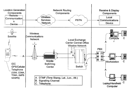
FIG. 1 is a simplified diagram of one embodiment of the present invention in a
telecommunications network.
FIG. 2 is a block diagram of an implementation of the invention to support a
public
2C~ safety answering point (PSAP).
FIG. 3 illustrates a process for call taker refreshing remote caller location
data.
FIG. 4 illustrates a location-based call routing methodology according to the
invention.
FIG. 5 is a simplified, overview block diagram of one embodiment of the
invention
25~ in a system implementation. This .system includes a satellite positioning
system (SPS), a
Remote Communication Apparatus (RCA) {e.g. a cell phone or other wireless
mobile unit)
having SPS location capability, a Telecommunication Service Apparatus (TSA) in
communication with the Cellular 'telecommunications Switching System (CTSS),
and a call
receiver or "call taker" apparatus (CRA) in communication with the CTSS,
optionally via
30 the Public Switched Telephone Network (PSTN).
FIG. 6 is a block diagram showing greater detail of the Remote Communications
Apparatus, which includes components and methods to generate time-stamped, 3
axis geo-
CA 02382924 2002-05-17
WO 98/53573 ~ ~ w°'~ PCT/US9$/10317
position data representative of the apparatus' position relative to 3-axes in
a system
implementation of the invention.
FIG. 7 is a block diagram showing greater detail of the Network Service
Apparatus,
which includes components and methods to process CTSS and PSTN call setup
signaling,
query the Remote Communication Apparatus, receive, decode, format, and perform
a
network related service (e.g. Call path determination) based on 3-axis geo-
position data
communicated by the Remote Communication Apparatus.
FIG. 8 is a block diagram showing greater detail of the Call Receiver
Apparatus to
process CTSS, PSTN, and PBX call setup signaling, query the Remote
Communication
'10 Apparatus, receive, decode, format, and perfornn a 3-axis geo-position
related service (e.g.
Personnel & fleet management, and E91 I location identifications based on the
3-axis geo-
position data communicated by the Remote Communication Apparatus.
FIG. 9 is an illustration of dual-tone location data signaling.
FIG. I OA is a simplified block diagram of a first alternative wireless mobile
unit.
FIG. l OB is a simplified block diagram of a second alternative wireless
mobile unit.
FIG. IOC is a simplified block diagram of a third alternative wireless mobile
unit.
FIG. l OD is a simplified block diagram of a fourth alternative wireless
mobile unit.
FIG. 11 is a simplified block diagram of a fifth alternative wireless mobile
unit.
FIG. 12 is simplified block diagram of a display unit, which can be mobile or
stationary, for indicating location of a remote unit on a map display.
FIG. 13A is a cross-sectional view of an example of a wireless mobile unit
whereby
the SPS is disposed within the power supply housing.
FIG. 13B is a cross-sectional view of an example of a wireless mobile whereby
the
SPS is on the power supply housing.
2;i FIG. 13C is a cross-sectional view of an example of a wireless mobile in
which the
SPS is located under the power supply housing.
FIG. 14 is a simplified block diagram of a hardware architecture that can be
used to
implement SPS location error correction.
FIG. 15 is a flowchart of a process of correcting SPS location data.
CA 02382924 2002-05-17
WO 98153573 - ''f ~ .y~ P~'IUS98/10317
DETAILED DESCRIPTION OF PRESENTLY PREFERRED EMBODIMENTS
Hardware Overview
Refening to Figure 5, a Remote Communication Apparatus (RCA) 10 is configured
to communicate to one or more NSA 12, and said CRA 14, a time stamped, 3 axis
geo-
position of the remote device within a telecommunication network. In this
description, the
RCA is also variously referred 1:o as a remote unit, mobile unit or cell
phone, the cell phone
being but one example. As another example, the RCA can be a communication unit
built
into a motor vehicle to provide location data in the event the vehicle is lost
or stolen; it need
not necessarily be a conventianal cell phone.
Referring now to Figure 6, according to one illustrative implementation, the
RCA 10
is comprised of, but not limited to; a Satellite Positioning System (SPS)
Receiver Antenna
24, an SPS Receiver Chip 26, an SPS Data Processor 30, a Central Processor
Unit 34, a
Random Access Memory Module (RAM) 38, an Electronically Erasable &
Programmable
Read Only Memory Module (EEPROM) 16, a Radio Frequency (RF) Transceiver
Antenna
68, an RF Transceiver 66, a Voice & Data Signal Coder/Decoder Processor 62, a
Tone
Generation & Detection Module 48, a User Interface Display 58, and a User
Activation
Interface 42. It is noteworthy that many of these components already exist in
a conventional
cell phone design, so redesign or retrofit to implement the invention requires
minimum
effort and expense. For example, while the SPS receiver components must be
added, the
existing CPU and memory components can be shared.
Referring to Figure 7, an embodiment of a Network Service Apparatus (NSA) 12
is
arranged so that the apparatus NSA 12 is able to communicate with a plurality
of said RCA
10, and CRA 14, so that the apparatus 12 can provide a 3 axis geo-position
relational
telecommunication network data services. Examples of such services include
call route
determination, 3 axis geo-position related call metering, etc. based on 3 axis
geo-position
data received from a plurality of said RCA 10. In one illustrative
implementation the NSA
12 is comprised of, but not limited to; a Satellite Positioning System (SPS)
Receiver
Antenna 104, an SPS Receiver Chip 106, an SPS Data Processor 110, a Central
Processor
Unit 86, a Radio Frequency (RF') Transceiver Antenna 72, an RF Transceiver 74,
a Voice &
Data Signal Coder/Decoder Processor 78, a Tone Generation & Detection Module
82, a
Communication Network Interface Device 128, a 3 axis Geo-position Data Related
Service
CA 02382924 2002-05-17
WO 98I53S73 ~ ..:,~ -~ PtT/US98/10317
Application 90, a 3 axis Geo-position Correction Database 210, and a 3 axis
Geo-position
Relational Database Service 212.
Referring now to Figure 8, the Call Receiver Apparatus (CRA) 14 is configured
to
communicate with a plurality of said RCA 10, and NSA 12, so that said
apparatus 14 can
provide a 3 axis geo-position relational data service to users of'said RCA 10,
and said CRA
14 based on 3 axis geo-position data received from one or more RCA 10, and 3
axis geo-
position relational data received from the NSA 12. According to one
illustrative
implementation, the CRA 14 includes, but not limited to; a Satellite
Positioning System
(SPS) Receiver Antenna 154, an SPS Receiver Chip 156, an SPS Data Processor
160, a
Central Processor Unit 152, a Voice & Data Signal Coder/Decoder Processor 196,
a Tone
Generation & Detection Module 148, a 3 axis Geo-position Data Related Service
Application 170, a 3 axis Geo-position Correction Database 166, and a 3 axis
Geo-position
Relational Database Service 178, a User Activation Interface 188, and a User
Display
Interface 186. The RCA need not necessarily be mobile. It can implemented in
an ordinary
home telephone, or a computer 'with an SPS receiver, etc. When a call is made
from the
device, its exact location is sent to the CRA. This can be useful, for
example, to give exact
location in a large building or industrial complex in case of emergency.
Conventional ANI
location lookup may be unavailable, inaccurate or simply not adequately
precise.
Acquiring Location Data In The Remote Communications Apparatus
Referring again to Figure 6, the Electronically Erasable & Programmable Read
Only
Memory (EEPROM)16, is a device located within, but not limited to, said RCA
10, and is
pre-programmed with instructions sets, or micro-code to initialize said SPS
Data Processor
26, said CPU 34, and said Tone Generation & Detection Module 48 at the onset
of power to
said RCA 10. The micro-code establishes operating parameters with which said
devices
will control and process data according to the methods of this invention.
When said RCA 10 enters a "power on" condition, the micro-code initializes
said '
SPS Data Processor 26 to a preset data format type, for output to said
Formatted SPS Data
Path 32. The micro-code also initializes said SPS Data Processor 26 to a
preset data output
flow rate value to said Formatted SPS Data Path 32. Finally, the micro-code
initializes said
SPS Data Processor 26 to a preset data output occurrence rate value, or
refresh rate value to
said Formatted SPS Data Path 32.
CA 02382924 2002-05-17
WO 98/53573 - '.~",! ~'-~ pCT/US98/1031~ -.
The micro-code then initializes said Tone Generation 8c Detection Module 48 to
the
preset tone detection modes, or data format input to be received from said
Communication
Control & 3 axis Geo-position Data Transmit Path 46, and from said Decoded-
Voice;
Communication Control & 3 axis Geo-position Data Input Path 102. Said Tone
Generation
& Detection Module 48 is also initialized to a preset detection mode, or data
output format
to be transmitted to said Communication Control & 3 axis Geo-position Data
Transmit Path
60, and to said Communication Control & 3 axis Geo-position Data Input Path
50. The said
Tone Detection & Generation Module 48 is initialized to a preset data input
flow rate value
for detecting data from said Communication Control &c 3 axis Geo-position Data
Transmit
Path 46, and from said Decoded-Voice, Communication Control & 3 axis Geo-
position Data
Input Path 102. The Tone Detection & Generation Module 48 is then initialized
to a preset
data output flow rate value for data output to said Communication Control & 3
axis Geo-
position Data Transmit Path 60, and to the Communication Control & 3 axis Geo-
position
Data Input Path 50. The Tone Generation & Detection Module 48 is then
initialized for a
preset data occurrence rate value, or refresh rate value to said Communication
Control & 3
axis Geo-position Data Transmit Path 60, and to said Communication Control & 3
axis
Geo-position Data Input Path 50.
The CPU 34 is initialized to a preset "event trigger" value. The "event
trigger" is a
pre-programmed sequence of data or conditional inputs, via micro-code, to said
CPU 34,
which results in the execution of subsequent, sequential processes, and
events, also
preprogrammed via the micro-code into said EEPROM 16. The event trigger may be
activate by any number of inputs to said CPU 34, to include, but not be
limited to; input
from user of said RCA 10 via said User Activation Interface 42, input received
from said
NSA 12 as preset Communication Control Commands (e.g. network audible
signaling),
input received from the CRA 14 as preset Communication Control Commands, or
audible
commands from a user of the CRA 14. Finally, the CPU is initialized as to
preset data
processing methods, and communication parameters (i.e. baud :rate, data size,
etc.).
The presentation of said Micro-code Output Path I8 establishes a connection of
said
EEPROM 16 to said CPU 34, s<iid SPS Data Processor 30, and said Tone Detection
&
Generation Module 48 for initialization to preset operating parameters at the
onset of a
"power on" condition of said RCA 10. In the present embodiment of the
invention, the said
SPS Data Processor 30 is connected to said CPU 34, via a communications bus,
and
11
CA 02382924 2002-05-17
WO 98153573 -~ '~ PCT/US98/10317
therefore receives initialization presets prom said EEPROM 16, via commands
from said
CPU 34. As the SPS Data Processor, the said Tone Detection & Generation Module
48 is
connected via a communications bus to said CPU 34, and also receives
initialization presets
from said EEPROM via said CPU 34.
The Satellite Positioning System (SPS) Network 20 is comprised of a plurality
of
geo-orbiting satellites, which broadcast a standardized format data packet
over a given radio
frequency. The data packet is readily received, converted, and made into
useful data, given
the implementation of the fotiowing devices in the present embodiment of the
invention; the
SPS Receiver Antenna 24, connected to an SPS Receiver Chip 26, connected to an
SPS
Data Processor 30, and an SPS Receiver Antenna 104, connected to an SPS
Receiver Chip
106, connected to an SPS Data Processor 110, and an SPS Receiver Antenna 154,
connected
to an SPS Receiver Chip 156, connected to an SPS Data Processor 160. The
connected.
devices are either embedded or connected to a respective apparatus as
illustrated and are
pre-programmed with micro-code to process the SPS Data Transmission 22
signals.
SPS Data Transmission 22 is a continuous, or streaming broadcast of data
messages
which are time-synchronized to an atomic clock. Because SPS Data Transmission
22 is
present 24 hours a day, 7 days a week, 365 days a year, is synchronized to
extremely low
tolerances, and exists globally, the SPS Data Transmission 22 is well
recognized as the most
accurate, and available means of obtaining static and dynamic 3 axis geo-
position data.
:20 The SPS Receiver Antenna 24 implemented within the preferred embodiment of
the
RCA 10, is capable of receiving a specific range of said SPS Data
Transmissions, and can
operate within a wide range of operating environments. SPS Receiver Antenna 24
is
appropriately sized for the current utilization with said RCA 10, however size
and radio
frequency shielding should be considered when embedding said SPS Receiver
Antenna
~5 within, or close proximity to said. Radio Frequency (RF) Transceiver 66
embedded within
same said RCA 10. A presently preferred implementation of said SPS Receiver
Antenna 24
is connected to said SPS Receiver Chip 26 via an appropriate physical means as
specified
by the Antenna 24 manufacturer and the SPS Receiver Chip 26 manufacturer.
SPS signals are received by said SPS Receiver Chip 26 from the SPS Receiver
30 Antenna 24, and is converted into "raw", or non-formatted, binary SPS data
streams, which
are then passed on to said SPS Data Processor 30, via the Raw SPS Data Output
Path 28.
SPS Data Processor 30 receives the unformatted, or "Raw" binary SPS data
streams via
12
CA 02382924 2002-05-17
WO 98/53573 .:'~"J ~ PCT/US98/10317
connection to said SPS Receiver Chip 26. In a presently preferred
implementation the SPS
Data Processor 30 is embedded into, or connected to the RCA 10. The SPS Data
Processor
30 executes a pre-programmed instruction set, or micro-code specific to the
manufacturer of
said SPS Data Processor 30. The micro-code instructs said SPS Data Processor
30 to
sample the incoming raw data stream, and acquire (lock onto) received SPS
satellite signals
within a preset decibel (dB) range, and then perform a validation of SPS data
messages from
said SPS Satellites 20. The said SPS Data Processor 30 then correlates a 3
axis geo-
position, relative to the center of the geoID (earth), based on the time-
synchronized data
messages received from the said SPS Network 20 satellites that are within view
of said SPS
Receiver Antenna 24, and append the 3 axis geo-position data with data
relative to the static,
or dynamic position of said RCA 10, the time of said correlation, and validity
of the
correlated 3 axis geo-position coordinates. Per the initialization process at
the onset of a
"power on" condition, said SPS Data Processor 30 formats the correlated 3 axis
geo-position
data, and communicates the data at the preset data output flow rate, and
refresh rate to said
Central Processor Unit (CPU) 34, via the Formatted Geo-position Data Output
Path 32.
The non-validated, formatted 3 axis geo-position data is received by the CPU
34 via
said Formatted 3 axis geo-position data output path 32, and is temporarily
stored in a
Random Access Memory Module 38, via the Non-validated 3 axis Geo-position Data
Storage Path for validation processing. The method for validating formatted 3
axis geo-
position data as embodied in the present invention, retrieves the non-
validated 3 axis geo-
position data from the said RAM 38, via the Non-validated 3 axis Geo-position
Data Path
40, and examines the data for the; presence of a character, or signal which
defines "Valid" or
"Not Valid" 3 axis geo-position data, per the manufacturer of said SPS Data
Processor. If
the 3 axis geo-position data is reported as "Not Valid", then said CPU 34
ignores the 3 axis
25~ geo-position data in temporary storage within said RAM 38, and continues
to sample the 3
axis geo-position data input frorr~ said SPS Data Processor. If the 3 axis geo-
position data
reported as "Valid", then said CPU 34 temporarily stores, or updates said RAM
38 with
"Valid", formatted 3 axis geo-position data via the Valid 3 axis Geo-position
Data Storage
Path 52. In the preferred embodiment of the invention, this process begins at
the onset of a
"power on" condition of the RCA 10, and continues irrespective of other
processes
performed by the RCA 10, until a "power off' condition is achieved, or other
pre-
programmed micro-code instructs said CPU 34 otherwise.
13
CA 02382924 2002-05-17
WO 98!53573 ' '--~ ""~ PCTIUS98/10317
In the present embodiment of the invention, when said RCA 10 is in a "power
on"
condition, a number of means may be utilized to initiate an active 3 axis geo-
position related
communication session. The user of said RCA 10, can initiate a sequence of
commands via
the User Activation Interface 42, which represent a pre-programmed event
trigger, in which
the RCA 10 will proceed to communicate a 3 axis geo-position to either said
NSA 12, or
said CRA 14. The User Activation Interface 42 can take the form of a single
momentary
switch used only in special circumstances, or as a regular RCA 10. The,User
Activation
Interface 42 may also be in the form of a key pad, allowing the user to
initiate the event
trigger via a pre-programmed sequence of key presses, communicated to the CPU
34 via the
User Activation Interface Path 44.
The User Activation Interface 42 may also be in the form of a measurement
device
embedded in, or attach to the RCA 10 via the User Activation Interface Path
44, which
measures environmental, dynamic, and static inputs of the RCA 10, the user, as
well as
those detectable conditions of the environment in the immediate vicinity of
the RCA 10.
This allows the measurement device, which now acts as an automated User
Activation
Interface 42, initiate an event trigger when a pre-programmed condition has
been satisfied
(accelerometer input, timer input, temperature input, etc.). The User
Activation Interface 42
may also be in the form of an on-board audio detection device connected to
said CPU 34 via
the User Activation Interface Path 44, which utilizes a speech recognition
algorithm,
;20 allowing the user to initiate the event trigger via a selected natural
spoken, phonetic
language (English, Japanese, Chinese, French, German, etc.).
In a presently preferred implementation of said User Activation Interface, all
inputs
by the user of the RCA 10, and communication control commands, and 3 axis geo-
position
relational data received by the RCA 10, is sent to the User Display Interface
58 via the
a5 Communication Control & 3 axi s Geo-position Related Data Display Output
Path 56. This
provides the user with feedback that the proper sequence of user activation
inputs were
processed to initiate an 3 axis geo-position communication event trigger. 3
axis geo-
position related data received from said NSA 12, and said CRA 14 can also be
displayed in
the present embodiment of the invention.
;i0 Another method for initiating a 3 axis geo-position communication session,
is for the
Call Receiver Apparatus (CRA) 14 to initiate a communication session with said
RCA 10.
When a communication channel has been established between said devices, the
CRA 14
14
CA 02382924 2002-05-17
WO 9$/535T3 ~ ".;J '~''j PC17US98/10317
may use a signaling method, or query command, which is pre-programmed into
both
devices, causing the RCA 10 to respond by transmitting a 3 axis geo-position
to said CRA
14.
Interaction With The Network Service Apparatus
The RCA 10 initiates a communication path to the NSA 12. When a communication
path is established between the RCA 10 and the NSA 12, the CPU 34 is
instructed by the
pre-programmed micro-code to automatically send "Valid" 3 axis geo-position
data to the
NSA 12. The NSA 12 can be automatically instructed by the 3 axis Geo-position
Data
Related Service Application 90, to automatically send a recognized
communication control
command back to the RCA 10, when a communication session has been initiated by
said
RCA 10.
Referring again to Figure 7, the 3 axis Geo-position Data Related Service
Application 90 sends the pre-programmed communication control data to the CPU
8b via
the Communication Control & 3 axis Geo-position Related Data Output Path 92.
The CPU
86 sends the communication control data on the Tone Detection & Generation
Module 82
via the Communication Control & 3 axis Geo-position Data Related Transmit Path
94. The
communication control data is then converted into an audio tone representation
of the data
by the tone generation function of the Tone Detection & Generation Module 82.
The audio
tone signaling preferably is DTMF or another multiple (2 or more) tone
frequency protocol.
Since DTMF is an international telecommunications standard protocol, the
invention can be
used with virtually all telephony signaling devices, analog or digital,
including e.g. ISDN,
DS-0,1, CAMA, FGD, DMA, TDMA, GSM, AMPS, etc. The tone data is then forwarded
to the Voice/Data Signal De/Coder Module 78 via the Communication Control 3
axis Geo-
position Data Related Transmit Path 96. This device formats the audio tones
into a data
stream appropriate to the manufactures method of transmitting voice & data via
the Radio
Frequency (RF), Coded-Voice, Communication Control and 3 axis Geo-position
Data Path
70 (CDMA, TDMA, NAMPS, GSM, VHF, UHF, etc.).
Location Data Encoding
In a presently preferred embodiment, location data is encoded in to at least
one
string, while additional strings of data can be transmitted as well,
automatically or upon
CA 02382924 2002-05-17
WO 98153573 - _,.~ "'~ PCT/US98110317 .
request. The basic string contains time stamp, latitude, longitude and
altitude data. The
time stamp comprises 3 characters - minute, second, second. For example, at
08:22:33 the
time stamp is 2,3,3 as the hour and tens of minutes are ignored. This much is
adequate
because location data is updated frequently, for example every second or two.
For data
correction, described later, a 60-second array of data is maintained. That
implies 60
samples or locations are stored, based on one update per second. The latitude
requires 8
characters, and longitude 9 characters, and altitude 3 characters. So in a
preferred ..
embodiment a basic data string is 23 characters long. Additional. strings can
be used to
transmit, for example, direction vector and speed.
Each data character is translated, for example by a lookup table, to a
corresponding
set of two or more audio frequency tones. Preferably, DTMF is used, although
other
multiple tone encoding can be used. A tone set or pair is transmitted for a 40
msec burst,
followed by a 40 msec blank. Thus one character of data is transmitted every
80 msec
during transmission of the basic string. The 23 characters defining the string
will take a
total of 23 x 80 msec or 1.8 seconds. Of course this protocol is merely
illustrative; the
number of audio tones, tone frequencies, burst size, burst rate, and refresh
rate etc. can all be
selected as desired for a particular application. In any event, the resulting
audio burst (1.8
second transmission) is added to the audio channel, and coexists along with
(or is added to )
the voice content. It need not be annoying to the user. The audio level or
amplitude of the
211 data burst can be controlled by the CPU or preset. The data burst can be
made relatively
low level - barely audible - so that one can talk right over it. On the other
hand, it is
preferred especially for emergency calls to the PSAP that the tones be plainly
audible, as
this provides reassurance to the user that the line is active, and indeed
location data is
updating.
Returning now to the description of the apparatus, the coded-communication
control
data is sent to the Radio Frequency (RF) Transceiver 74 via the Coded-Voice,
Communication Control and 3 axis Geo-position Data Path 98. The RF Transceiver
74 then
converts the input data from the Voice/Data Signal De/Coder Module 78 into an
RF
transmission, at a frequency pre-determined by the manufacturer of said
device. The data
3(1 transmission is then emitted from the RF Transceiver Antenna 72, to the
RCA 10 RF
Transceiver Antenna b8. Referring now to Figure 6, the signal is received via
the RF,
Coded-Voice, Communication Control & 3 axis Geo-position Data Path 70. The
signal
16
CA 02382924 2002-05-17
WO 98/53573 "'J ~ PCT/US98/10319
received by the RF Transceiver Antenna 68 sends the signal to the RF
Transceiver 66. The
RF Transceiver 66 then converts the received signals to a format which is pre-
determined by
manufacturer of said RF Transceiver 66 and is usable by the Voice/Data Signal
De/Coder
Module 62, which receives the communication control data via the Coded-Voice,
Communication Control and 3 axis Geo-position Data Input Path 100. The
Voice/Data
Signal De/Coder 62 uses a decoding algorithm, pre-programmed by the
manufacturer of
said VoiceJData Signal De/Coder 62 to re-assemble the received data into a
format usable
by the Tone Detection & Generation Module 48. The decoded communication
control data
is then sent to the Tone Detection & Generation Module 48 via the Decoded-
Voice,
11) Communication Control and 3 axis Geo-position Data Input Path 102. The
communication
control data is received by the tone diction function of the Tone Detection &
Generation
Module 48, and is then converted from an audio tone representation of the data
to a format
preset by the manufacturer of said Tone Detection & Generation Module 48,
which is usable
by the CPU 34 of the RCA 10. The communication control data is then received
by the
1:i CPU 34 via the Communication Control & 3 axis Geo-position Data Input Path
50. Per the
pre-programmed micro-code, the CPU 34 recognizes the communication control
input data
as a command to communicate 3 axis geo-position data to the NSA 12.
When an event trigger has been enabled (user activation input, or
communication
control input), the CPU 34 executes a set of instructions so as to communicate
3 axis geo
2() position data. As the CPU 34 continues to receive, validate, and update
the RAM with
"Valid" data, the CPU 34 samples the RAM 38, via the Valid 3 axis Geo-position
Data Path
52, for cun:~ent "Valid" 3 axis geo-position data. If 3 axis geo-position data
from the SPS
Data Processor 30 is "Not Valid", then the CPU 34 maintains, retrieves via the
Valid 3 axis
Geo-position Data Retrieval Path 54, and communicates the last "Valid" 3 axis
geo-position
2'.i data, until new "Valid" 3 axis geo-position data is obtained, and updated
into RAM 38. If
"Valid" data is not realized by the CPU 34 after a preset rimeout condition
has been
achieved, the CPU 34 will default to communicating the "Not Valid" data.
During the sampling and communication of said "Valid" 3 axis geo-position
data,
the CPU 34 disables the 3 axis geo-position data validation process, so that
existing "Valid"
30 data is not corrupted, erased, or over-written during the sampling and
communication
sequence. However, during the transmission of "Not Valid" 3 axis geo-position
data, the
validation process continues, and in the event "Valid" 3 axis geo-position
data is realized,
17
CA 02382924 2002-05-17
WO 9853573 'vJ 'v''~ PGTNS98/10317
the CPU 34 will intemipt the transmission of "Not Valid" 3 axis geo-position
data, update
the RAM 38 with "Valid" 3 axis geo-position data, and proceed to transmit the
new "Valid"
3 axis geo-position data. -
The CPU 34 sends the data to the Tone Detection & Generation Module 48 via the
Communication Control & 3 axis Geo-position Data Transmit Path 46. The "Valid"
geo-
position data is then converted into an audio tone representation of the data
by the tone
generation function of the Tone Detection & Generation Module 48. This data is
then
forwarded to the Voice/Data Signal De/Coder Module 62 via the Communication
Control 3
axis Geo-position Data Transmit Path 60. This device formats the audio tones
into a data
stream appropriate to the manufactures method of transmitting voice & data via
the Radio
Frequency (RF), Coded-Voice, Communication Control and 3 axis Geo-position
Data Path
70 (CDMA, TDMA, NAMPS, GSM, VHF, UHF, etc.).
The Coded-Voice, Communication Control and 3 axis Geo-position Data is then
sent to the Radio Frequency (RF) Transceiver 74 via the Coded-Voice,
Communication
Control and 3 axis Geo-position Data Path 64. The RF Transceiver 74 then
converts the
input data from the Voice/Data Signal De/Coder Module 62 into an RF
transmission, at a
frequency pre-determined by the manufacturer of said device. The data
transmission is then
emitted from the RF Transceiver Antenna 68, to the NSA 12 RF Transceiver
Antenna 72 via
the RF, Coded-Voice, Communication Control & 3 axis Geo-position Data Path 70.
The
signal received by the RF Transceiver Antenna 72 sends the signal to the RF
Transceiver
74. The RF Transceiver 74 then converts the received signals to a format which
is pre-
determined by manufacturer of said RF Transceiver and is usable by the
Voice/Data Signal
DelCoder Module 78, which receives the data via the Coded-Voice, Communication
Control and 3 axis Geo-position Data Path 76. The VoicelData Signal DelCoder
78 uses a
decoding algorithm, pre-programmed by the manufacturer of said Voice/Data
Signal
De/Coder 78 to re-assemble the r eceived data into a format usable by the Tone
Detection &
Generation Module 82. The decoded 3 axis geo-position data is then sent to the
Tone
Detection & Generation Module 82 via the Decoded-Voice, Communication Control
and 3
axis Geo-position Data Path 80. The 3 axis geo-position data received by the
tone diction
:30 function of the Tone Detection & Generation Module 82, and is then
converted from an
audio tone representation of the data to a format preset by the manufacturer
of said Tone
Detection & Generation Module 82, which is usable by the CPU 86 of the NSA 12.
The 3
18
CA 02382924 2002-05-17
WO 98/53573 - 'J =~ PCTNS98/10317
axis geo-position data is then received by the CPU via the Communication
Control & 3 axis
Geo-position Data Path 84. The CPU 86 sends the "Valid" 3 axis geo-position
data to the 3
axis Geo-position Data Related Service Application 90 for processing, via the
Communication Control & 3 axis Geo-position Data Input Path 88.
The preferred embodiment of the NSA 12 uses a similar implementation as the
RCA
10, of embedded, or connected SPS devices to the NSA 12. The use of 3 axis geo-
position
data from said devices, however, is for the purposes of correcting the "built-
in" error of said
SPS Transmission Data 22, as further explained later.
The preferred implementation of said SPS Receiver Antenna 104 is as currently
exists in the present embodiment of the invention. The said SPS Receiver
Antenna 104
implemented within the preferred embodiment of said NSA 1 Z, is capable of
receiving a
specific range of said SPS Data Transmissions, and can operate within a wide
range of
operating environments. The said SPS Receiver Antenna 104 is appropriately
sized for the
current utilization with said NSA 12, however size and radio frequency
shielding is to be
considered when embedding said SPS Receiver Antenna within, or close proximity
to said
Radio Frequency (RF) Transceiver 74 embedded within same said NSA 12. The
preferred
implementation of said SPS Receiver Antenna 104 is connected to said SPS
Receiver Chip
106 via an appropriate physical means as set forth by said SPS Receiver
Antenna 104
manufacturer and said SPS Receiver Chip 106 manufacturer.
SPS signals are received by said SPS Receiver Chip 106 from said SPS Receiver
Antenna 104, and is converted into "raw", or non-formatted, binary SPS data
streams, which
are then passed on to said SPS Data Processor 110, via said Raw SPS Data
Output Path 108.
The SPS Data Processor 110 receives unformatted, or "Raw" binary SPS data
streams via
connection to said SPS Receiver Chip 106. The present, and preferred
implementation of
said SPS Data Processor 110, is embedded into, or connected to said NSA 12.
The said SPS
Data Processor 110 executes a pre-programmed instruction set, or micro-code
specific to the
manufacturer of said SPS Data Processor 110. The micro-code instructs the SPS
Data
Processor 110 to sample the incoming raw data stream, and acquire (lock onto)
received
SPS satellite signals within a preset decibel (dB) range, and then perform a
validation of
SPS data messages from said SPS Satellites 20. The said SPS Data Processor 110
then
correlates a 3 axis geo-position, ,relative to the center of the geoID
(earth), based on the
time-synchronized data messages received from the said SPS Network 20
satellites that are
19
CA 02382924 2002-05-17
WO 98153573 ~ '~ w'~ PCTNS98/10317
within view of said SPS Receiver Antenna 104, and appends the 3 axis geo-
position data
with data relative to the static, or dynamic position of said NSA 12, the time
of said
correlation, and validity of the correlated 3 axis geo-position coordinates.
Per the
initialization process at the onset of a "power on" condition, said SPS Data
Processor 110
formats the correlated 3 axis geo-position data, and communicates the data at
the preset data
output flow rate, and refresh rate to said Central Processor Unit (CPU) 86,
via the Formatted
3 axis Geo-position Data Output Path 112.
The CPU 86 is instructed by the 3 axis Geo-position Data Related Service
Application 90 to perform a validation on the formatted 3 axis geo-position
data input. If
the 3 axis geo-position data is found to be "Valid", the CPU 86 will send the
3 axis geo-
position data to the 3 axis Geo-position Correction Database 210 for future
input to a 3 axis
geo-position errar correction algorithm, via the 3 axis Geo-position
Correction Database
Record Input Path 114.
The 3 axis Geo-position Data Related Service Application 90 receives the 3
axis
geo-position data communicated by the RCA 10, and performs a validation on the
received
data. If the data is corrupt, the 3 axis Geo-position Data Related Service
Application 90 will
transmit a communication control command back to the RCA 10, to send 3 axis
geo-
position data. Upon receipt of validated 3 axis geo-position data from the RCA
10, the 3
axis Geo-position Data Related Service Application 90 examines the time-stamp
of the
received 3 axis geo-position data fiom the RCA 10. The said application 90
then queries
the 3 axis Geo-position Correction. Database via the Database Query Path 116
to return a 3
axis geo-position correction record with the same time-stamp via the Database
Record
Return Path 118.
The 3 axis Geo-position Data Related Service Application implements an error
correction algorithm which utilizes two dynamically updated variable data
inputs, and a user
defined variable data input. The user defined variable data input represents a
professionally
surveyed, or bench-marked 3 axis geo-position of the NSA 12. This 3 axis geo-
position
represents a known location from which to reference deviations of correlated
SPS
Transmission Data 22. The first dynamic variable data input is the 3 axis geo-
position
received by the local SPS Data Processor 110, and connected SPS devices, which
is stored
in said 3 axis Geo-position Correction Database 210. This data represents the
correlated 3
axis geo-position of the NSA 12, and is used in conjunction with the user
defined variable,
CA 02382924 2002-05-17
W098I53573 - -.:~ :""'J PCTNS98110317
to calculate a 3 axis geo-position deviation factor from the known, or bench-
marked 3 axis
geo-position. The second dynamic variable data input is the "Valid" 3 axis geo-
position
data received from the RCA 10. This data represents the correlated 3 axis geo-
position of
the RCA, and is used in conjunction with the computed 3 axis geo-position
deviation factor,
in order to calculate a corrected 3 axis geo-position of said RCA 10. Position
correction
methods and apparatus are described further below with reference to Figures 14
and 15.
Network Implemented Services
After performing an error correction on the RCA 10 3 axis geo-position, the 3
axis
'10 Geo-position Data Related Service Application 90 then forwards the 3 axis
geo-position
data to a 3 axis Geo-position Relational Database Service 212, via the
Corrected 3 axis Geo-
position Data Input Path 120. 'This service 212 utilizes the corrected 3 axis
geo-position
data of the RCA 10, in order to return a pre-determined data record via the 3
axis Geo-
position Relational Data Output Path 122, relative to the 3 axis geo-position
communicated
'15 by the RCA 10, which would enable the user of said NSA 12 to perform a
network related
service for user of said RCA 10, or user of said NSA 12, based on the 3 axis
geo-position
relational data input to said Geo-position Data Related Service Application
90. In some
cases, said 3 axis Geo-position Relational Database Service 212 may never
return a 3 axis
geo-position relational data record to the 3 axis Geo-position Data Related
Service
l0 Application 90, but instead would store the 3 axis geo-position of said RCA
10, for future
processing, or communication to services outside the realm of this invention.
The 3 axis Geo-position Data Related Service Application 90 in the present
embodiment of the invention can perform any one of several actions. Said
application 90
can send further communication control, and 3 axis geo-position relational
data back to the
5 user of said RCA 10. The said application 90 can send 3 axis geo-position
relational data to
a Communication Network Interface Device 128, via the Communication Control &
3 axis
Geo-position Relational Data Path 124, enabling said application 90 to send
communication
control data, 3 axis geo-position deviation factor data, uncorrected 3 axis
geo-position data
of said RCA 10, corrected 3 axis geo-position data of said RCA 10, and the
associated 3
axis geo-position relational data to a plurality of telecommunication network
devices via the
Communication Control & 3 axis Geo-position Data Path 130. The final option is
that said
application 90 performs no further action, and merely performs all processes
to a process
21
CA 02382924 2002-05-17
WO 98153573 ''~'l "i'~ PCTNS98110317
point pre-defined in said application 90 code, or the user of said application
In one illustrative implementation of the invention, the NSA 12 performs a
service
for said RCA 10 utilizing said application 90 to determine a destination of
the
communication session event. The application 90 would send the 3 axis geo-
position
relational data to the CPU 86 via the Communication Control & 3 axis Geo-
position Related
Data Output Path 92. The CPU 86 then sends the data to said Communication
Network
Interface Device via said Communication Control & 3 axis Geo-position
Relational Data
Path 124. The Communication Network Interface Device 128 sends and receives
communication control data, and/or 3 axis geo-position relational data to a
plurality of
14 network devices connected to a Cellular Telecommunications Switching System
(CTSS)
134 via the Communication Control & 3 axis Geo-position Relational Data Path
130. In
some implementations of the invention, the 3 axis Geo-position Data Related
Service
Application requires feedback, or other 3 axis geo-position relational data
from a plurality
of telecommunications network devices comprising of either a CTSS 134, a PSTN
138, or
PBX 202. This data is received by the Communication Network Interface Device
128 via
the Communication Control & 3 axis Geo-position Relational Data Path 130, and
is sent to
the CPU 84 via the Communication Control ~ 3 axis Geo-position Relational Data
Input
Path 126.
Referring once again to Figure S, communication control data and/or 3 axis geo-
position relational data is then forwarded by the CTSS 134 to one of several
paths.
Depending on the destination, or service requested by the user of said RCA 10,
the CTSS
134 may then forward the communication session to another RCA 10 utilizing the
same, or
different said CTSS 134, in effecet assuming a similar role as the CRA 14.
Because the
destination of the communication session is with another RCA 10 implementing
the same
methods of this invention, the users of both RCA's 10 have the ability to send
and receive
communication control and 3 axis geo-position data to the other RCA 10. In the
present
embodiment of the invention, the call is forwarded from the CTSS 134 to the
destination
RCA 10 via the Communication Control & 3 axis Geo-position Data Path 130. The
communication session request is received by the RCA 10 via a cellular
communication
control method which exists irrespective of this invention. When the user of
said
destination RCA 10 accepts the communication session request, the plurality of
CTSS 134
telecommunication network devices use existing functionality to complete a
22
CA 02382924 2002-05-17
WO 98/53573 - '~ - J~ PGT/US98/10317
communications circuit represented by the Coded-Voice, Communication Control
and 3
axis Geo-position Data Path 70, and the Voice, Communication Control & 3 axis
Geo-
position Data Path 132.
Depending on the pre-programmed micro-code, and the action of the users of
both
the originating and receiving RC,A's 10, any number of 3 axis geo-position
data event
triggers may enable the communication of 3 axis geo-position data from one RCA
10 to the
other. Also, depending on the processing capability of said CPU' 34, the pre-
programmed
micro-code, and/or attached peripheral devices to either the originating or
receiving RCA's
10, they may be capable of perfo~ining an error correction on 3 axis geo-
position data.
'10 Another option of the CTSS 134 is to forward the communication session,
and
associated communication control and 3 axis geo-position relational data to a
plurality of
telecommunication network devices comprising a Public Switched Telephone
Network
(PSTN) 138, via the Communication Control & 3 axis Geo-position Data Path 136.
Depending on the service requested by the user of said RCA 10, and/or the 3
axis
'15 geo-position relational data forw~~rded to the PSTN I38, the communication
session
destination may be forwarded by said PSTN 138 via a Voice, Communication
Control & 3
axis Geo-position Data Path 198, to a PSTN subscribing (e.g. POTS) CRA 14.
Depending on the service requested by the user of said RCA 10, andlor the 3
axis
geo-position relational data forwarded to the PSTN 138, the communication
session
:>_0 destination may be forwarded by said PSTN 138, via the Communication
Control & 3 axis
Geo-Position Related Data Path 140 to a CRA 14 acting as a call receiving
"Agent" within a
Private Branch Exchange Network 202.
Depending on the service requested by the user of said RCA 10, and/or the 3
axis
geo-position relational data forwarded to the CTSS 134, the communication
session
:?5 destination may be forwarded to a CRA 14, connected to said CTSS 134, as a
call receiving
"Agent" within a Private Branch :Exchange Network 202.
Operation Of The Call Receiver Apparatus (Cra)
Acceptance of the communications session by the CRA 14, completes a
:30 communication circuit back to said RCA 10, now enabling direct 3 axis geo-
position
communication between said RC.A 10 and said CRA 14, via the Communication
Control &
3 axis Geo-position Data Related Transmit Path 192; the Communication Control
3 axis
23
CA 02382924 2002-05-17
WO 98/53573 ' ~ '-°~ PCTIUS98110317
Geo-position Data Related Transmit Path 194; the Voice, Communication Control,
and 3
axis Geo-position Data Path 198, the Voice, Communication Control, and 3 axis
Geo-
position Data Path 206; the Voice, Communication Control, and 3 axis Geo-
position Data
Path 132; the Coded-Voice, Convnunication Control and 3 axis Geo-position Data
Transmit
Path 98; the RF, Coded-Voice, Communication Control and 3 axis Geo-position
Data Path
70; the Coded-Voice, Communication Control and 3 axis Geo-position Data Input
Path 100;
the Decoded-Voice, Communication Control and 3 axis Geo-position Data Input
Path 102;
the Communication Control & 3 axis Geo-position Data Input Path 50; the
Communication
Contml & 3 axis Geo-position Data Transmit Path 46; the Communication Control
& 3
axis Geo-position Data Transmit Path 60; the Coded-Voice, Communication
Control and 3
axis Geo-position Data Path 64; the Coded-Voice, Communication Control and 3
axis Geo-
position Data Path 76; and the Decoded-Voice, Communication Control and 3 axis
Geo-
position Data Path 146 as described above. If CRA 14 is implemented in a PBX
communication environment, then the following additional representations of;
the Coded-
'15 Voice, Communication Control and 3 axis Geo-position Data Path 200; the
Voice,
Communication Control, and 3 axis Geo-position Data Path 204; the Voice,
Communication
Control, and 3 axis Geo-position Data Path 206; and the Voice, Communication
Control,
and 3 axis Geo-position Data Path 208 are applicable.
Depending on the implementation of said CRA 14, in a PBX 202 environment, the
communication control and or 3 axis geo-position related data is received by
the PBX 202
via the Communication Control & 3 axis Geo-Position Related Data Path 140 from
the
CTSS 134, or the Communication Control & 3 axis Geo-Position Related Data Path
142
from the PSTN 138, and is received by said CRA 14 via the Communication
Control & 3
axis Geo-Position Related Data Path 144.
c'.5 The RCA 10 initiates a communication path to said CRA 14. When a
communication path is established between the RCA 10 and the CRA 14, the CPU
34 is
instructed by the pre-programmed micro-code to automatically send "Valid" 3
axis geo-
position data to the CRA 14. The CRA 14 can be automatically instructed by the
3 axis
Geo-position Data Related Service Application 170, to automatically send a
recognized
30 communication control command back to the RCA 10, during a communication
session
with said RCA 10.
The 3 axis Geo-position Data Related Service Application 1?0 sends the pre-
24
CA 02382924 2002-05-17
WO 98/53573 "~ '~,'"~ PCTNS98/10317
programmed communication control data to the CPU 152 via the Communication
Control &
3 axis Geo-position Related Data Output Path 182. The CPU 152 sends the
communication
control data on the Tone Detection & Generation Module 148 via the
Communication
Control & 3 axis Geo-position Data Related Transmit Path 192. The
communication
control data is then converted into an audio tone representation of the data
by the tone
generation function of the Tone Detection & Generation Module 148. This data
is then
forwarded to the Voice/Data Signal De/Coder Module 196 via the Communication
Control
3 axis Geo-position Data Related Transmit Path 194. This device formats the
audio tones
into a data stream appropriate to the manufactures method of transmitting
voice & data via
the Coded-Voice, Communication Control and 3 axis Geo-position Data Path 200,
(ISDN,
Analog).
In a PBX 202 implementation of the invention, the coded-communication control
data is sent to the PBX 202 via the Coded-Voice, Communication Control and 3
axis Geo-
position Data Path 200. Depending on the communication circuit path, the PBX
202
decodes the data, and forwards the communication control data to the PSTN 138
via the
Voice, Communication Control, and 3 axis Geo-position Data Path 204, which in
turn,
forwards said communication control data to said CTSS 134 via the Voice,
Communication
Control, and 3 axis Geo-position Data Path 206, or the PBX 202 decodes said
data, and
forwards the communication control data directly to the CTSS 134. Otherwise
the
communication data is sent to the PSTN 138 via the Voice, Communication
Control and 3
axis Geo-position Data Path 198.
The CTSS 134 sends the communication control data to the NSA 12 via the Voice,
Communication Control, and 3 axis Geo-position Data Path 132. Said data is
received by
the Voice/Data Signal De/Coder 78. This device formats the audio tones into a
data stream
appropriate to the manufactures method of transmitting voice & data via the
Radio
Frequency (RF), Coded-Voice, Communication Control and 3 axis Geo-position
Data Path
70 (CDMA, TDMA, NAMPS, GSM, VHF, UHF, etc.). The RF 'Transceiver 74 then
converts the input data from the Voice/Data Signal De/Coder Module 78 into an
RF
transmission, at a frequency pre-determined by the manufacturer of said
device. The data
transmission is then emitted from the RF Transceiver Antenna 72, to the RCA 10
RF
Transceiver Antenna 68 via the RF, Coded-Voice, Communication Control & 3 axis
Geo-
position Data Path 70. The signal received by the RF Transceiver Antenna 68
sends the
CA 02382924 2002-05-17
WO 98153573 ~ ~ "~"~ PCT/US98/1031?
signal to the RF Transceiver 66. The RF Transceiver 66 then converts the
received signals
to a format which is pre-determined by manufacturer of said RF Transceiver 66
and is
usable by the VoicelData Signal De/Coder Module 62, which receives the
communication
control data via the Coded-Voice, Communication Control and 3 axis Geo-
position Data
Input Path 100. The Voice/Data Signal De/Coder 62 uses a decoding algorithm,
pre-
programmed by the manufacturer of said Voice/Data Signal De/Coder 62 to re-
assemble the
received data into a format usable by the Tone Detection & Generation Module
48. The
decoded communication control data is then sent to the Tone Detection &
Generation
Module 48 via the Decoded-Voice, Communication Control and 3 axis Geo-position
Data
Input Path 102. The communication control data is received by the tone diction
function of
the Tone Detection & Generation Module 48, and is then converted from an audio
tone
representation of the data to a format preset by the manufacturer of said Tone
Detection &
Generation Module 48, which is usable by the CPU 34 of the RCA 10. The
communication
control data is then received by the CPU 34 via the Communication Control & 3
axis Geo-
'15 position Data Input Path 50. Per the pre-programmed micro-code, the CPU 34
recognizes
the communication control input data as a command to communicate 3 axis geo-
position
data to the NSA 12.
When an event trigger has been enabled (user activation input, or
communication
control input), the CPU 34 executes a set of instructions, to communicate 3
axis geo-
position data. CPU 34 continues to receive, validate, and update the RAM with
"Valid"
data. CPU 34 samples said RAM 38, via the Valid 3 axis Geo-position Data Path
52, for
current "Valid" 3 axis geo-position data. If 3 axis geo-position data from
said SPS Data
Processor 30 is "Not Valid", then the CPU 34 maintains, retrieves via the
Valid 3 axis Geo-
position Data Retrieval Path 54, and communicates the last "Valid" 3 axis geo-
position data,
until new "Valid" 3 axis geo-position data is obtained, and updated into RAM
38. If
"Valid" data is not realized by the. CPU 34 after a preset timeout condition
has been
achieved, the CPU 34 will default. to communicating the "Not Valid" data.
During the sampling and communication of said "Valid" :3 axis geo-position
data,
the CPU 34 disables the 3 axis geo-position data validation process, so that
existing "Valid"
3n data is not corrupted, erased, or over-written during the sampling and
communication
sequence. However, during the transmission of "Not Valid" 3 axis geo-position
data, the
validation process continues, and in the event "Valid" 3 axis geo-position
data is realized,
26
CA 02382924 2002-05-17
WO 98/53573 ~ 'J ~ PCTNS98110317
the CPU 34 will interrupt the transmission of "Not Valid" 3 axis geo-position
data, update
the RAM 38 with "Valid" 3 axis geo-position data, and proceed to transmit the
new "Valid"
3 axis geo-position data.
The CPU 34 sends the data, to the Tone Detection & Generation Module 48 via
the
!i Communication Control & 3 axis Geo-position Data Transmit Path 46. The
"Valid" geo-
position data is then converted into an audio tone representation of the data
by the tone
generation function of the Tone Detection & Generation Module 48. This data is
then
forwarded to the Voice/Data Signal De/Coder Module 62 via the Communication
Control 3
axis Geo-position Data Transmit Path 60. This device formats the audio tones
into a data
stream appropriate to the manufactures method of transmitting voice & data via
the Radio
Frequency (RF), Coded-Voice, Communication Control and 3 axis Geo-position
Data Path
70 {CDMA, TDMA, NAMPS, GS:M, VHF, UHF, etc.).
The Coded-Voice, Communication Control and 3 axis Geo-position Data is then
sent to the Radio Frequency {RF) Transceiver 66 via the Coded-Voice,
Communication
Control and 3 axis Geo-position Data Path 64. The RF Transceiver 66 then
converts the
input data from the Voice/Data Signal De/Coder Module 62 into an RF
transmission, at a
frequency pre-determined by the manufacturer of said device. The data
transmission is then
emitted from the RF Transceiver Antenna 68, to the NSA 12 RF Transceiver
Antenna 72 via
the RF, Coded-Voice, Communication Control & 3 axis Geo-position Data Path 70.
The
2() signal received by the RF Transceiver Antenna 72 sends the signal to the
RF Transceiver
74. The RF Transceiver 74 then converts the received signals to a format which
is pre-
determined by manufactwer of said RF Transceiver and is usable by the
Voice/Data Signal
De/Coder Module 78, which receives the data via the Coded-Voice, Communication
Control and 3 axis Geo-position Data Path 76. The Voice/Data Signal DeICoder
78 uses a
2;i decoding algorithm, pre-programmed by the manufacturer of said Voice/Data
Signal
De/Coder 78 to re-assemble the received data into a format usable by the CTSS
134. The
NSA 12 sends the uncorrected 3 axis geo-position data to the CTSS 134 via the
Voice,
Communication Control, and 3 axis Geo-position Data Path 132.
Depending on the communication circuit path, said CTSS 134 forwards the 3 axis
30 geo-position data to the PBX 202 via the Voice, Communication Control, and
3 axis Geo-
position Data Path 208, or sends the 3 axis geo-position data to the PSTN via
the Voice,
Communication Control, and 3 axis Geo-position Data Path 206, which in turn
forwards
27
CA 02382924 2002-05-17
WO 98/535T3 W _:.' PCT/US98II0317
said data to said PBX 202 via the Voice, Communication Control, and 3 axis Geo-
position
Data Path 204. Otherwise the communication data is sent to the PSTN 138 via
the Voice,
Communication Control and 3 axis Geo-position Data Path 206, which forwards
the data on
to said CRA 14 via the Voice, Communication Control, and 3 axis Geo-position
Data Path
198.
The PBX 202 codes the 3 axis geo-position data, and forwards said data to the
CRA
14 via the Voice, Communication Control, and 3 axis Geo-position Data Path
144.
The 3 axis geo-position data received by the Voice/Data Signal De/Coder 196
uses a
decoding algorithm, pre-programmed by the manufacturer of said VoicelData
Signal
70 DelCoder 196 to re-assemble the received data into a format usable by the
Tone Detection
& Generation Module 148. The decoded 3 axis geo-position data is then sent to
the Tone
Detection & Generation Module 148 via the Decoded-Voice, Communication Control
and 3
axis Geo-position Data Path 146. The 3 axis geo-position data received by the
tone diction
function of the Tone Detection & Generation Module 148, and is then converted
from an
audio tone representation of the data to a format preset by the manufacturer
of said Tone
Detection & Generation Module 148, which is usable by the CPtT 152 of the CRA
14. The
3 axis geo-position data is then received by the CPU 152 via the Communication
Control &
3 axis Geo-position Data Path 150. The CPU 152 sends the "Valid" 3 axis geo-
position data
to the 3 axis Geo-position Data Related Service Application 170 for
processing, via the
fD Communication Control & 3 axis Geo-position Data Input Path 168.
The preferred embodiment of the CRA 14 uses a similar implementation as the
NSA
12, of embedded, or connected SPS devices to the CRA 14. The use of 3 axis geo-
position
data from said devices, however, is for the purposes of correcting the "built-
in" error of the
SPS Transmission Data 22 as further described below.
A presently preferred implementation of the SPS Receiver Antenna 154 is
embedded
within the CRA 14, is capable of receiving a specific range of SPS Data
Transmissions, and
can operate within a wide range of operating environments. The Antenna 154 is
connected
to said SPS Receiver Chip 156 as specified by the SPS Receiver Antenna
manufacturer and
the SPS Receiver Chip 156 manufacturer.
The preferred implementation of said SPS Receiver Chip 156 is as currently
exists in
the present embodiment of the invention. SPS signals are received by said SPS
Receiver
Chip 156 from said SPS Receiver Antenna 154, and is converted into "raw", or
non-
28
CA 02382924 2002-05-17
WO 98!53573 ~ "'''~ -~ PCT/US98/10317
formatted, binary SPS data streams, which are then passed on to said SPS Data
Processor
160, via said Raw SPS Data Output Path 162. Further details of the CRA SPS
receiver
components and operation are analogous to the corresponding circuits in the
RCA and or the
NSA and therefore will be abbreviated here.
The CPU 152 is instructed by the 3 axis Geo-position Data Related Service
Application I70 to perform a validation on the formatted 3 axis geo-position
data input. If
the 3 axis geo-position data is found to be "Valid", the CPU 152 will send the
3 axis geo-
position data to the 3 axis Geo-position Correction Database 166 for future
input to a 3 axis
geo-position error correction algorithm, via the 3 axis Geo-position
Correction Database
Record Input Path 164.
The 3 axis Geo-position Data Related Service Application 170 receives the 3
axis
geo-position data communicated by the RCA 10, and performs a validation on the
received
data. If the data is corrupt, the ~ axis Geo-position Data Related Service
Application 170
will transmit a communication control command back to the RC.A 10, to send 3
axis geo-
115 position data. Upon receipt of validated 3 axis geo-position data from the
RCA 10, the 3
axis Geo-position Data Related Service Application 170 examines the time-stamp
of the
received 3 axis geo-position data from the RCA 10. The said application 170
then queries
the 3 axis Geo-position Correction Database via the Database Query Path 172 to
return a 3
axis geo-position correction record with the same time-stamp via the Database
Record
~?0 Return Path 174.
The 3 axis Geo-position Data Related Service Application implements an error
correction algorithm which utilizes two dynamically updated variable data
inputs, and a user
defined variable data input. The user defined variable data input represents a
professionally
surveyed, or bench-marked 3 axis. geo-position of the CRA 12. This 3 axis geo-
position
25 represents a known location from which to reference deviations of
correlated SPS
Transmission Data 22. The first dynamic variable data input is the 3 axis geo-
position
received by the local SPS Data Processor 160, and connected SPS devices, which
is stored
in said 3 axis Geo-position Correction Database 166. This data represents the
correlated 3
axis geo-position of the CRA 14, and is used in conjunction with the user
defined variable,
;30 to calculate a 3 axis geo-position deviation factor from the known, or
bench-marked 3 axis
geo-position. The second dynamic variable data input is the "Valid" 3 axis geo-
position
data received from the RCA 10. This data represents the correlated 3 axis geo-
position of
29
CA 02382924 2002-05-17
WO 98/53573 ~ "'J PCTNS981103I7
the RCA, and is used in conjunction with the computed 3 axis geo-position
deviation factor,
in order to calculate a corrected 3 axis geo-position of said RCA 10.
After performing an error correction on the RCA 10 3 axis geo-position, the 3
axis
Geo-position Data Related Service Application 170 then forwards the 3 axis geo-
position
data to a 3 axis Geo-position Relational Database Service 178, via the
Corrected 3 axis Geo-
position Data Input Path 176. This service 178 utilizes the corrected 3 axis
geo-position
data of the RCA 10, in order to return a pre-determined data retard via the 3
axis Geo-
position Relational Data Output lPath 180, relative to the 3 axis geo-position
communicated
by the RCA 10, which would enable the user of said CRA 14 to perform a 3-axis
geo-
position related service for user c~f said RCA 10, or user of said CRA 14,
based on the 3 axis
geo-position relational data input to said Geo-position Data Related Service
Application
170. In some cases, said 3 axis CTeo-position Relational Database Service 178
may never
return a 3 axis geo-position relational data record to the 3 axis Geo-position
Data Related
Service Application 170, but instead would store the 3 axis geo-position of
said RCA 10, for
future processing, or communication to services outside the realm of this
invention.
In the present embodiment of this invention, the user of said CRA 14 interacts
with
said application 170 by entering data variables into said application 170 via
the User
Activation Interface 188. A variety of inputs, similar to those of the RCA can
be utilized to
provide data input to either change operational characteristics of the CRA, or
change event
trigger parameters. In the case of a person attended CRA 14, feedback is
provided to the
user via a connected User Display Interface 186. Those 3 axis geo-position
data related
services which require the user of said CRA 14 to view the 3 axis geo-position
relational
data results, utilize the application 170 to drive said 3 axis geo-position
relational data
results to the CPU 152, which in turn forwards the data to said User Display
Interface via
the Communication Control & 3 axis Geo-position Related Data Display Output
Path.
The 3 axis Gea-position Data Related Service Application 170 performs the
primary
function of receiving 3 axis geo-position data from a Remote Communication
Apparatus 10,
or said Network Service Apparatus 12, and enable the user of said 3 axis Geo-
position Data
Related Service Application 1?0 to perform a service for user of said RCA 10,
and said
CRA 14. 3 axis geo-position related applications may include but not be
limited to; asset
tracking, personnel and fleet management, directory assistance, concierge
services, process
control, personal location, public safety location services, navigation,
telecommunication
CA 02382924 2002-05-17
WO 98/53573 ~ "J "f PCT/US98/10317
network management, and so forth.
Location Data Correction
As mentioned briefly above, an important aspect of the invention is a method
and
apparatus for correcting SPS-derived location data received from a remote
communication
device such as a cell phone. It is known that certain degradation of satellite
signals leads to
inaccuracies in acquired position information. (The GPS apparently provides
more accurate
information to the military, NASA, etc. but not to the public.) The present
invention
provides a solution for overcoming these inaccuracies to provide precise
location data.
The correction technique is implemented at a fixed location, which can be
virtually
anywhere that GPS signals are visible for reception. Ln one embodiment of the
invention,
that fixed location is a part of the communications network, for example at a
cell site,
CTSS, telephone central office, etc. In another embodiment, the fixed location
can be a
home, office or other place of business, and in particular the fixed location
can be a PSAP.
It is advantageous for many applications to provide the fixed location within
the
communications network where a cell call, particularly an emergency or 911
call, is routed,
so that location-based routing can be accomplished with enhanced accuracy as
further
explained below.
Thus another feature of the invention provides for dynamic routing of a call,
for
example an emergency 911 call, based on highly accurate, corrected location
data. This
ensures that the most appropriate emergency or public safety services provider
receives
needed information as quickly as possible. A location error of a few meters,
for example,
can make the difference between dispatching a call to local police or to
highway patrol
where the precise emergency location is actually on an urban highway. On the
coast
highway, as another example, only a few meters may mean the difference between
the need
for land-based ambulance or a distress call to the Coast Guard for a water
rescue.
Referring now to Figure 14, to provide location data correction, an SPS
antenna
1402 is installed at the fixed location. The actual physical location of that
antenna is
accurately determined, for example by survey, and recorded in memory. An SPS
receiver
1404 is coupled to the fixed antenna, and SPS location data of the fixed
antenna is acquired
and processed in an SPS processor 1406. The processor 1406 provides output
data
comprising a time stamp, latitude, longitude and altitude data, for example as
an ASCII
31
CA 02382924 2002-05-17
WO 98/535T3 ~ '-"'~ .~:~% PCTIUS98/10317
stream of bytes in a predetermined format. Commercially available SPS
receivers and
processors can be programmed to provide a desired output format, for example
over a serial
port. This data is updated frequently, for example every few seconds. (This
data can be
expected to suffer from the "selective availability" degradation built into
SPS
transmissions.) The acquired fixed antenna position data is delivered to a
system
microprocessor 1408 and stored (via bus 1410) in a memory. The data is stored
in the
memory so as to form a dynamic or circular array so that, for example, the
most recent 60
seconds of data is maintained at all times. If data is acquired say, every 1
second on
average, there will be sixty samples in the array, although this number is not
critical.
Memory space is provided as appropriate.
An RF receiver or transceiver 1416 for cell telephone reception is coupled to
a
voice/data code and decode module 1418 to decode incoming signals into digital
data. This
data is input to a tone detection module 1420 to detect the audio tones that
represent the cell
phone location. The resulting data, further processed by the microprocessor
1408 if
necessary, to form the cell location data sample preferably comprising a time
stamp,
latitude, longitude and altitude. 'fhe cell location data sample is stored,
for example in a
memory location 1422 via bus 1410. Program code for execution by the
microprocessor to
carry out these operations can be provided in a memory 1426, preferably a read-
only
memory. The stored cell location data is corrected according to the following
methodology.
Referring now to Figure 15, a process of correcting the cell location data
begins with
acquisition of location data 1502 from the fixed SPS antenna ( 1402 in Fig.
14), responsive
to an initialization step 1504. While at first blush it may seem odd to
acquire SPS location
data at a known, fixed location, the utility of doing so will become apparent.
The acquired
fixed antenna location data (after the usual processing, not shown) is stored
in an array of
memory as noted above. Periodically, fox example as indicated by checking a
programmable timer {or by hardware interrupt, etc.), new location data is
acquired and the
array is updated. This process 1502, 1506 is repeated so that an array of
location data is
maintained, reflecting the most recently acquired data, for example over a
period of 60
seconds.
3fJ Next, SPS-derived location data is received 1508 from a remote wireless
apparatus,
as mentioned with reference to Figure 14. Based on the latitude and longitude
(and
optionally altitude as well) indicated in the received data, a distance of the
wireless
32
CA 02382924 2002-05-17
WO 98/53573 ~ "'~ PCTNS98/10317
apparatus to the fixed location is c;alcuiated 1510. That distance is compared
to a
predetermined range, say 100 kilometers, step 1 S l2. If the calculated
distance exceeds the
selected range, 1 S 14, no correction is applied to the received data 1516,
and the process
loops via "A" to acquire new data from the remote apparatus. This is done
because where
the distance is great the probability increases that satellites in view at the
remote location are
not the same as the satellites in view at the fixed location at the same time.
If the calculated distance is within the selected range, step 1518, the time
stamp of
the remote location data sample is read 1520, and the memory array containing
the fixed
antenna location data is interrogated 1522 to see if a sample having the same
time stamp
value is in the array (indicating a "fix" on the fixed location was acquired
at the same time
as the "fix" was acquired on the remote apparatus). If a matching time stamp
is found in the
an~ay 1524, that data is used to calculate a 3-axis correction factor, step
1526, calculated as
the difference in each of the three dimensions, as between the selected fixed
antenna
location data sample, and the known, actual location of the fixed antenna.
This difference
indicates the effective errors in the satellite transmitted data, for that
fixed location, at the
exact time the remote location data was acquired by the remote apparatus. The
timing is
critical because the satellite degradation is not static. The next step 1528
is correcting the
remote location data by applying t:he calculated corrections. Then the process
loops to "A"
to acquire new location data from the remote object. The described process
thus reverses
the "selective availability" signal degradation of the SPS. When a matching
time stamp is
found, an application can confidently expect location accuracy within 10
meters.
If the calculated distance is within correction range, but no matching time
stamp is
found in the array of fixed antenna location samples, 1530, a correction
factor can still be
calculated by averaging the corrections over all of the samples in the array,
step 1532. This
will provide a useful approximation, as it is highly likely that the remote
data was acquired
within the past 60 seconds, during. which the fixed antenna data was also
acquired.
In a presently preferred embodiment, the error correction can be provided in a
Network Service Apparatus (NSA) 12, as described earlier with reference to
Figure 7. In
Figure 7, the geo-position correction database 210 stores the array of fixed
antenna location
data samples described above. The CPU 86 of Figure 7 corresponds to the
microprocessor
1408 of Figure 14; the SPS data processor 110 of Figure 7 corresponds to the
SPS
processor 1406 of Figure 14, and so forth.
33
CA 02382924 2002-05-17
WO 98/53573 - ~ j'~ PGT/US98/10317
In the alternative, or in addition, the error correction can be implemented in
the call
taker CRA, as illustrated in Figure 8. In this case, the geo-position
correction database 166
stores the array of fixed antenna location data samples described above. The
CPU 152 of
Figure 8 corresponds to the microprocessor 1408 of Figure 14; the SPS data
processor 160
of Figure 8 corresponds to the SPS processor 1406 of Figure 14, and so forth.
In our previously filed patent applications, we disclosed an improved system
and
method to communicate time stamped (time as UTC), 3-axis (3~: as Latitude, Y
as
Longitude, and Z as Altitude) geo-position data of a remote communication
apparatus,
through the audio traffic channel. of a telecommunication network, to a
network service
and/or call receiver apparatus capable of receiving 3 axis geo-position data,
and in turn
performing a 3 axis geo-position relational service for the user of each
apparatus. The
present invention provides huge cost savings, for example in the public safety
or emergency
response sectors (dial 911 in the U.S.) by using the existing cell telephone
network
infrastructure, combined with a global positioning system, and several novel
enhancements,
to provide precise user location information.
We further described previously a wireless system for voice and data
communications, such as a Personal Communication System (PCS), in which
latitude-
longitude-altitude (3 axis) location is embedded in the communications signals
of the
communication system for the determination of the location of the PCS user by
a Satellite
Positioning System (SPS), such as the Global Positioning System or Global
Orbiting
Navigational Satellite System. In each such embodiment, the apparatus includes
a plurality
of antenna, a power supply, a device to process the SPS data, a communications
device, and
a remote display unit connected by a wireless link.
The previous applications illustrated a mobile system (FIG. 10A), in which the
PCSlSPS device includes an SPS antenna 1002 and receiver 1004 to receive the
SPS
signals; an SPS signal frequency downconverter 1005; an SPS signal processor
100? to
receive converted antenna output signals and process them to provide a present
location and
altitude of the PCS/SPS user as well as the time of observation; a display
processor 1010
and display 1011; a transceiver 1003 to receive processor output signals and
transmit these
signals through an antenna 1001 as a multiplexed 1008 data packet along with
the
voice/data stream inputs 1009; and a power supply 1006.
The display unit (FIG. 12) includes an antenna 1201; a transceiver 1202 to
receive
34
CA 02382924 2002-05-17
WO 98/53573 - "~ -~ PCT/US98/10317
the signals transmitted by the PCS/SPS mobile system transceiver, a computer
based
processor 1203 to receive and demultiplex output signals from the receiver, a
voice/data
input output system 1204; an SPS data buffer 1205; a data output system 1206;
a system to
display location by a computer based mapping system 1207; and a power supply
1209. We
thus disclosed wireless switching and routing functionality with embedded 3
axis location
data, either by terrestrial or satellite wireless systems.
We earlier described wireless systems that transmit voice and data
communications,
such as a Personal Communication System (PCS), cell phone or radio, in which
latitude-
longitude-altitude (3 axis) location is added to the system for the express
purpose of
embedding data packets or streams in the communications signals of the
communication
system for the determination of the location of the PCS user by a Satellite
Positioning
System (SPS), such as the Global Positioning System or Global Orbiting
Navigational
Satellite System. In each embodiment, the apparatus includes a plurality of
antenna, a
plurality of power supplies, a device to process the SPS data, a
communications device, a
communications link and a remote display unit connected by a wireless link.
We illustrated mobile systems as in FIG. 10B, in which the SPS (unit 2)
supplies a
data stream (e.g. NMEA ) to the PCS (unit 1 ) by a communications link to a
signal
multiplexer 1028. Mobile unit 2 includes an SPS antenna 1022 and receiver 1024
to receive
the SPS signals; an SPS signal frequency downconverter 1025; an SPS signal
processor
1027 to receive converted antenna output signals and process them to provide a
present
location and altitude of the PCS/SPS user as well as the time of observation;
a display
processor 1030 and display 1031. Unit 1 includes a transceiver 1023 to receive
processor .
output signals and transmit these signals thmugh an antenna 1021 as a
multiplexed 1028
data packet along with the voice/data stream inputs 1029; and a power supply
1026. In a
second embodiment, the SPS is located in the voice input (microphone) housing
and the
data stream is embedded in or included as a data packet in the voice stream.
Figure l OD
shows another embodiment.
The display unit (FIG. 12) in the prior application includes an antenna 1201;
a
transceiver 1202 to receive the signals transmitted by the PCS/SPS mobile
system
transceiver; a computer based processor 1203 to receive and demultiplex output
signals
from the receiver; a voice/data input output system 1204; an SPS data buffer
1205; a data
output system 1206; a system to display location by a computer based mapping
system
CA 02382924 2002-05-17
WO 98/53573 ~ ""'~ ..' PCT/US98/10317
1207; and a power supply 1209.
A wireless system for voice arid data communications, such as a Personal
Communication System (PCS), in which latitude-longitude-altitude (3 axis)
location is
embedded in the communications signals of the communication system for the
determination of the location of the PCS user by a Satellite Positioning
System (SPS), such
as the Global Positioning Systerr~ or Global Orbiting Navigational Satellite
System. In the
event of loss of positioning signal, an initial platform such as a Solid State
Rotation Sensor
like Gyro-Chip Ih~~ or equal, to maintain two dimensional changes in
geographic location.
In each embodiment, the apparatus includes a plurality of antenna, a power
supply, a device
to process the SPS data, an inertial platform, a communications device, and a
remote display
unit connected by a wireless link.
In an alternative embodiment of the mobile system (FIG. l OC) the PCS/SPS
device
includes an SPS antenna 1042 and receiver 1044 to receive the SPS signals; an
SPS signal
frequency downconverter 1045; an SPS signal processor 1047 to receive
converted antenna
'~5 output signals and process them t.o provide a present location and
altitude of the PCS/SPS
user as well as the time of observation; an inertial platform 1053 to update
two dimensional
location in the event of signal loss; a display processor 1050 and display
1051; a transceiver
1043 to receive processor output signals and transmit these signals through an
antenna 1041
as a multiplexed 1048 data packet along with the voice/data stream inputs
1049; a power
c!0 supply 104f>; and a switching routing transponder 1052.
The display unit (FIG. 12) includes an antenna 1201; a transceiver 1202 to
receive
the signals transmitted by the PCS/SPS mobile system transceiver; a computer
based
processor 1203 to receive and demultiplex output signals from the receiver; a
voice/data
input output system 1204; an SPS data buffer 1205; a data output system 1206;
a system to
i'.5 display location by a computer Based mapping system 1207; and a power
supply 1209.
That embodiment employs the inertial platform's ability to accurately update a
user's location during periods of signal loss. The invention is useful in the
wireless
communications market for accurately updating, tracking and locating the user
during an
SPS data loss.
30 Another wireless system for voice and data communications, such as a
Personal
Communication System (PCS), is illustrated in which latitude-longitude-
altitude (3 axis)
location is embedded in the communications signals of the communication system
for the
36
CA 02382924 2002-05-17
WO 98/53573 ~ ~''', -~ PC?lUS98/10317 -
determination of the location of the PCS user by a Satellite Positioning
System (SPS) such
as the Global Positioning System or Global Orbiting Navigational Satellite
System in the
event of loss of positioning signal, a barometric pressure transducer and
signal processor
(digital altimeter), to maintain altitude changes in geographic location. In
each
embodiment, the apparatus includes a plurality of antenna a power supply, a
device to
process the SPS data, a digital altimeter a communications device, and a
remote display unit
connected by a wireless link.
In another alternative embodiment of the mobile system (FIG. 10C), the PCSJSPS
device includes an SPS antenna 1042 and receiver 1044 to receive the SPS
signals; an SPS
signal frequency downconverter 1045; an SPS signal processor 1047 to receive
converted
antenna output signals and process them to provide a present location and
altitude of the
PCS/SPS user as well as the time of observation; a digital altimeter 1053 to
update altitude
in the event of signal loss; a display processor 1050 and display 1051; a
transceiver 1043 to
receive processor output signals and transmit these signals through an antenna
1041 as a
multiplexed 1048 data packet along with the voice data stream inputs 1049; a
power supply
1046; and a switching routing transponder 1052.
The display unit (FIG. I2) includes an antenna 1201; a transceiver 1202 to
receive
the signals transmitted by the PCS/SPS mobile system transceiver; a computer
based
processor 1203 to receive and demultiplex output signals from the receiver; a
voice data
~!0 input output system 1204; an SPS data buffer 1205; a data output system
1206; a system to
display location by a computer based mapping system 1207; and a power supply
1209. This
system employs the digital altimeter's ability to accurately update a users
location during
periods of signal loss.
Referring now to Figure 13, we illustrated an implementation for existing
wireless
e!5 mobile systems, E.g. Motorola Cellular Micro Tac Ultra Lite, Ericcson 338,
etc. (FIG. 13A),
that transmits voice conventionally or data communications through a port in
the wireless
device 1307. Referring to Figure I I, the SPS system is external to the
wireless mobile unit;
the apparatus includes a plurality of antenna 1101 and 1102, an SPS Radio
Frequency front
end or down converter 1103, a multi-channel SPS correlator with support
functions and
crystal clock 1104, an SPS Processor 1105, communications processor 1106, data
connection to the existing wireless mobile systems 1107, data multiplexer or
logic device
1109, a transceiver 1108, speakerlmicrophone assembly 1110, a power supply
which
37
CA 02382924 2002-05-17
WO 98/53573 -'~ '.~~ PCTNS98J10317
contains a rechargeable battery and components 1102-1106, and a wireless
infrastructure
that carries and routes the traffic channel. Additionally, in each embodiment,
the data which
includes latitude-longitude-altitude (3 axis) location is added to the system
for the express
purpose of embedding data packets or modulated data streams into the traffic
channel of the
communication system. In the embodiment of FIG. 13A, the SF'S is located
within the
power supply housing. In the alt:emative embodiment of FIG. 13B, the SPS is
located on
the power supply housing.
Referring to Figure 13, we described earlier the placement of the SPS system
in, on
or under the power supply 1331, removable battery, with data transfer through
an integrated
molded electrical connection manufactured to mate to the existing data port
1327, a
secondary data port in parallel with the original on the SPS device can be
added if required,
in order to maintain manufactures design functionality. Further this
transmission which
contains the embedded 3 axis location data, will be conveyed by terrestrial or
satellite
wireless systems in the traffic channel (voice). Figure 13C shows another
alternative
application.
Having illustrated and described the principles of our invention, it should be
readily
apparent to those skilled in the art that the invention can be modified in
arrangement and
detail without departing from such principles. We claim all modifications
coming within
the spirit and scope of the accompanying claims.
38