Note: Descriptions are shown in the official language in which they were submitted.
CA 02391285 2002-O1-24
WO 00/68907 PCT/US00/12297
AN ASSET AND PERSONNEL TAGGING SYSTEM UTILIZING GPS
Related Application
This application claims the benefit. under 3~ U.S.C. Section 119(e), of the
filing date
of prior provisional application serial number 60/132,772, filed May 6, 1999
and titled Local
Positioning System Designed for Outdoor Use.
Background of the Invention
1. Field of the Invention
l0 The present invention relates to locating objects.
2. Description of the Related Art
A new class of products is emerging in the marketplace. These systems are
designed
to track small, low-powered radio beacons that are attached to assets and
personnel in a
facility. The radio beacons are generally called "tags''. The tags can be read
at relatively long
range, typically in excess of 50 meters. Antennas are installed indoors or
outdoors in a grid-
like fashion to cover a complete facility. The antennas remain in continuous
contact with
tags in range of the antennas.
Systems of this type are known as "Local Positioning Systems" (LPS), "Real
Time
Locating Systems" (RTLS), or "Local Locating Systems" (LLS). All of these
names
emphasize the ability of the systems to cover a complete indoor space (as
distinct from
covering gateways or portals), read tags from long distances, and determine
tag locations.
The term LPS indicates that techniques similar to Global Positioning System
(GPS)
techniques are used to determine tag location. Other RTLS technologies
estimate location
based on reader proximity and/or signal strength. RTLS systems as a group are
distinguished
from Radio Frequency Identification (RFID) in that RFID systems are designed
to see tags at
short range only, and catch them as they pass fixed points in a constrained
process.
Referring to Fig. l, Local Positioning Systems (LPS) are designed to track
small, low-
powered radio beacons that are attached to assets and personnel in a facility.
One
3o commercially available LPS is Pinpoint's 3D-iD system, available from
Pinpoint
Corporation, 1 Fortune Drive, Billerica, MA 01821. 3D-iD is comprised of two
main
components, shown in Figure l, a mufti-antenna 102a-102d interrogator 101 that
sends Direct
CA 02391285 2002-O1-24
WO 00/68907 PCT/US00/12297
-2-
Sequence Spread Spectrum interrogation signals 110 at 2.44 GHz to tags 103
(only one
shown) that are in range. The tags transpond this interrogation signal, by
receiving the signal
at 2.44 GHz, mixing the carrier up to 5.80 GHz, filtering the result to comply
with regulatory
requirements, and transmitting a resulting FCC-compliant signal 112 at low
power in the 5.80
GHz band. Interrogator 101 receives this resulting signal, extracts the tag's
unique ID, and
determines the tag's distance to each antenna by measuring the signal's time
of arnval. By
comparing the time of arrival with the time of transmission, round trip time
of flight is
estimated and the distance between the tag and the antenna accordingly is
estimated.
Information from the interrogator is sent to a host computer 105 (host) using
a TCP/IP
protocol, typically via an Ethernet connection 104. The host calculates the
tag's location, and
makes the information available to application programs. Other implementations
of LPS
have been designed; some of which are commercially available. such as, FireFly
from
WhereNet, 2855 Bowers Ave, Santa Clara, CA, 95051. For the purpose of this
application,
it is to be understood that all such LPS systems share a requirement to
install a matrix of
interrogation points in order to read tags in range and determine their
locations. However,
there is a need for a system that can locate objects located outside of such
area of coverage.
Summary of the Invention
One embodiment of the invention is directed to an object locating system
utilizing
GPS including a tag, attached to the object, and a base station, having a
host. The tag
includes GPS circuitry, wireless LAN circuitry enabling communication between
the host and
the tag, and a power-saving feature. The power saving feature may take on
numerous forms.
Another embodiment of the invention is directed to a locating system for use
in an
application including at least one mobile vehicle and at least one mobile
object. The locating
system comprises: a base station on the vehicle, the base station including a
differential GPS
receiver; and a tag attached to the object. The tag includes: GPS circuitry;
and wireless LAN
circuitry for communicating information between the tag and the base station.
Inverted
differential GPS corrections are performed at the base station on tag
positional information.
The object may be an individual (person).
An even further embodiment of the invention is directed to a location system
for use
in an application including at least one mobile object. The location system
comprises: a host;
and a tag placed on the object. The tag includes: GPS circuitry; inertial
technology circuitry;
CA 02391285 2002-O1-24
WO 00/68907 PCT/US00/12297
-3-
and wireless LAN circuitry for communicating information between the tag and
the host.
When the tag loses communication with Navstar GPS satellites, the tag utilizes
inertial
technology to estimate its location as an offset to the last known GPS-based
location. The
object may be an individual.
Brief Description of the Drawings
Figure 1 shows an example LPS system.
Figure 2 shows the operation of a GPS tag.
Figure 3 shows the initialization of a GPS tag according to an embodiment of
the
l0 invention.
Figure 4 is a flow diagram of GPS tag operation according to an embodiment of
the
invention.
Figure 5 is a diagram showing a system according to an embodiment of the
invention.
Figure 6 is a flow diagram showing operation of a tag according to an
embodiment of
the invention.
Detailed Description
"Local Positioning Systems" (LPS), "Real Time Locating Systems" (RTLS) and
"Local Locating Systems" (LLS), as described in the background section of this
specification,
2o are designed to minimize tag cost. Tags do not "know" where they are.
Instead, a network of
interrogators work together to both provide coverage and determine tag
location. This
approach is effective when there are enough tags in an area to justify the
infrastructure cost.
When the density of tags is low, such as 25 or fewer tags per acre, it becomes
plausible to
consider schemes with higher tag cost, offset by a lower infrastructure cost.
There is a commercially available LPS known as Pinpoint 3D-iD (3D-iD)
available
through Pinpoint Corporation, Billerica, MA. 3D-iD is representative of LPS
systems in the
sense that it is designed to support a high density of low-cost tags, with
substantial cost per
square foot being placed in the infrastructure used to read the tags. This is
appropriate for
indoor applications where many assets are tracked in the absence of a usable
Global
3o Positioning System (GPS) signal.
CA 02391285 2002-O1-24
WO 00/68907 PCT/US00/12297
-4-
However, it is to be appreciated that part of the invention of this
application is that it
has been realized that there are numerous applications that are notable for
three application
characteristics:
1. Tags are placed on objects, such as trailers, that are not densely located
within an area;
2. The applications span large areas and, thus, are impractical to cover with
a network of
LPS readers, given the relatively low density of tags; and
3. GPS satellite signals are available.
For example, some outdoor applications may have tag densities of fewer than 25
tags
per acre. If interrogators are installed at a fully loaded cost of $0.10 per
square foot, this
1o results in a cost of about $4,000 per acre, plus the cost of the tags
themselves. Such
economics suggest that certain applications would benefit from a more
expensive tag
requiring minimal infrastructure. The above-defined three application
characteristics point
toward a design that incorporates a GPS receiver in a relatively sophisticated
tag. The low
density of tags justifies a more expensive tag in order to minimize the per-
square-foot cost of
15 yard coverage.
Such a tag can integrate two technologies. First, an inexpensive GPS receiver
enables
the tag to determine its own location. Second, a wireless radio technology
provides a link to
a host.
Low-cost GPS chip sets do not provide the 2-5 meter accuracy needed for many
LPS
2o applications. Therefore, a third technology is needed to improve accuracy
through
differential GPS. Differential GPS techniques, which give location accuracy in
the range of
2-5 meters, can be implemented in a way that does not appreciably increase tag
cost.
Additionally, the tag can be designed in a way to minimize power consumption,
thus
extending battery life.
25 A GPS-enabled tag according to an embodiment of the invention, will not
simply act
as a beacon; instead, it will ascertain its own location and communicate that
location to a host
computer. For outdoor applications, GPS chipsets from vendors such as Trimble
Navigation
Limited (749 North Mary Avenue, Sunnyvale, CA 94086) and SiRF Technology (148
E.
Brokaw Road, San Jose, CA 95112) are becoming inexpensive enough to embed in
tags; cost
3o is under $25 per tag in the Year 2000 and that is expected to decrease over
time. Likewise,
communication chip sets for industry standard protocols for wireless radio
(Com Radio) such
as 802.11 or DECT are currently available for under $50 and are expected to
rapidly decrease
CA 02391285 2002-O1-24
WO 00/68907 PCT/~1500/12297
-5-
in cost. With both of these technologies combined in a tag, costs in the range
of $100-$200
are achievable today, with further cost reductions likely into the future.
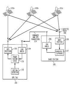
Figure 2 illustrates an embodiment of a system according to the invention,
which
includes a tag incorporating a GPS receiver, henceforth called a "GPS Tag".
The GPS Tag
202 receives navigation signals from a constellation of Navstar satellites,
represented by
201a, 201b, and 201c. A GPS Receiver 203 in the GPS tag decodes the navigation
signals
and estimates the tag's position. Several GPS Receivers are commercially
available, for
example one of Timble's Lassen GPS modules (such as the Lassen SK8). In one
embodiment, a low-cost receiver is used. providing relatively inaccurate
position estimates.
to These uncorrected position estimates are transmitted via signal 212 to the
Base Station 205
using Com Radios 204 (GPS Tag transmit) and 206 (Base Station receive).
Differential
corrections are applied at the Base Station. using an off the-shelf
Differential GPS (DGPS)
receiver technology 208. An example of an available DGPS is Trimble's Inverted
Differential GPS Base Station. The Differential Receiver 208 can be placed at
any
convenient pre-surveyed location 209 on the site, such as on the roof of a
warehouse. This
receiver is used to calibrate the errors received from each satellite in view,
which is applied to
the data received from tag 202. The result is a reasonably accurate estimate
of the tag's
location, in the range of 2-5 meters. which is good enough to distinguish a
location within
one or two parking spaces.
It is also possible to enable each tag for differential GPS, but with today's
technology
this would unnecessarily increase the cost of the tag. It is to be
appreciated, however, that for
applications with relatively few tags, such an approach may nonetheless be
preferable and is
intended to be within the scope of this application.
The Com Radio Modules 204 & 206 can be provided using one of the mainstream
Wireless Local Area Network (WLAN) standards, such as 802.11 or DECT/PCS. The
choice
is driven by other uses for the communication infrastructure. For example, if
the yard already
has 802.11 installed for support of mobile terminals, then 802.11 is a logical
choice.
DECT/PCS may be preferred where local voice applications predominate. The
costs per tag
are similar. with the communications circuitry costing less than $50 per tag,
and with that
cost rapidly decreasing. For a lower cost link, 900 MHz technology can also be
utilized. It is
to be appreciated that any wireless communication device can be used. that the
tag may be
broken up into its individual parts, and that these modifications are intended
to be within the
CA 02391285 2002-O1-24
WO 00/68907 PCT/IJS00/12297
-6-
scope of the invention. For example, the tagged item may be a vehicle that
already
incorporates a cell phone that might be used for the wireless connection; with
the caveat that
a public cellular network may be an expensive, power-hungry, and time-
consuming way to
send position updates (of a few bytes each) to a location that is not very far
away. In
addition, the Base Station Com Radio 206 is not necessarily co-packaged as
shown in Figure
2. For example, 802.11 access points are usually directly connected to an
Ethernet LAN.
To provide 802.11 coverage of an entire yard, several 802.11 access points may
be required.
Thus, the Com Radio 206 may actually be implemented as several remote radio
access points
communicating with the Base Station 205 over a LAN.
t 0 For vehicle applications, power for the tag can be drawn from the
batteries in the
vehicles. Alternatively, the tag can include batteries that may be recharged
by solar power.
For low cost and ease of installation. it is possible to employ simple
conventional batteries,
such as lithium cells. and use power judiciously for long life. The
architecture of a GPS
Tagging System provides several opportunities for power management to extend
the life of
15 such batteries.
It is not necessary for the GPS receiver to be enabled until it is in range of
a base
station. Accordingly, in one embodiment of the tag and system of the
invention, the tag is
normally asleep, waking up periodically to check if it is in range of a base
station. Most
commercially available Com Radios 204 and 206 include a flexible means for a
mobile radio
20 to efficiently search for a nearby network access point.
Once it is determined that a GPS Tag 202 is in the range of a Base Station
205, the
Base Station can transmit information that will help the GPS module decrease
its acquisition
time, as shown in Figure 3. Figure 3 is similar to Figure 2, except that the
reference/initialization data and commands are moving from the Base Station's
DGPS Station
25 208 to the GPS Tag's Power Saving Logic 215. This Power Saving Logic
dramatically
reduces the time the GPS Receiver needs to operate to determine its location.
GPS
parameters are provided from the Base Station to allow the GPS Receiver to
more quickly
synchronize with Navstar satellites. Commands from the Base Station control
the frequency
of determining the locations. A Motion Detector 216 in the GPS Tag helps
determine
30 whether it is necessary to update the Tag location. The purpose is to
enable the GPS
Receiver to use no more power than is necessary.
CA 02391285 2002-O1-24
WO 00/68907 PCT/LJS00/12297
Both to improve system response times and reduce power requirements of the
tag,
there are various ways that the tag and system of this embodiment of the
invention can take
advantage of the fact that the base station and the tag are in the same
vicinity. Trimble's
Lassen LP GPS module, which might be used in GPS Receiver 203, gives 4
specifications
for acquisition time. A cold start is specified as no initialization. and
takes 130 seconds. A
warm start, specified at 45 seconds, takes advantage of "that last position,
time, and almanac
are saved in battery-backed memory''; this information can be provided from
the Base Station
205 through the Coms Radios 206 and 204. A hot start, specified at 20 seconds,
"implies
ephemeris is also saved"; which the Base Station can also provide. Finally,
reacquisition
1o after signal loss is specified at 2 seconds. Since the Base Station is
reading almost the same
GPS signal as the tag, this information might also be downloaded by the Base
Station and
sent to the tag, with the main challenge being that the time base of the tag
and the base station
need to be synchronized. In the case of 802.11, the system is synchronous and
time slotted,
with a data transmission rate of about one bit every 1 microseconds (or less).
Thus, a
synchronous communications link can be used for time synchronization on the
order of about
1 microseconds, corresponding to about a 1000-foot error (light travels about
one foot per
nanosecond). Since the Base Station can also transmit the location and
altitude of the facility,
the tag can thus greatly limit its search and lock onto the satellites very
quickly.
For coarser-grained time synchronization, full packets can be used. Packet-
level time
2o synchronization yields accuracy on the order of the packet length, i.e.,
some fraction of a
millisecond.
In another embodiment of a tag and system of the invention, a motion detector
can be
used to help conserve power consumption. For additional power management of
tags
attached to vehicles and trailers, there are relatively few times that the tag
is both in motion
and within range of the base station (since the vehicles are parked for most
of their time in the
yard). Likewise, most assets stored outdoors are moved infrequently. Thus, a
motion
detector in the tag, such as a mercury fitter switch, can greatly reduce the
need to operate the
tag's GPS Receiver 203. Base Station Software 207 can also instruct the tag
when locations
need to be calculated. either in response to a user request or on a repeated
scheduled basis.
3o For example, an asset management system may command a specific tag to
recalculate its
position more frequently when a move is scheduled. Alternatively, all tags may
be
CA 02391285 2002-O1-24
WO 00/68907 PCT/US00/12297
_g_
commanded to recalculate their positions less frequently at night when a yard
is not in
operation.
In another embodiment of the tag and system of the invention. the
communications
capability of the tag can be leveraged for wireless monitoring of devices
throughout the yard.
For example, in trailers of refrigerated goods, the tag's communication module
can be
integrated with a temperature monitor to verify that the trailer's
refrigeration unit is operating
correctly. Similarly, vehicle parameters such as fuel levels. odometer
readings, hours of
operation, and so forth can be monitored by the tag and reported, which
combined with
vehicle location can be used for maintenance purposes.
1 o In another embodiment of the tag and system of the invention, the tags can
be used to
archive vehicle activities when it is outside of the range of a base station.
For example. after
the truck leaves the yard its location is calculated periodically, stored in
the tag's memory,
and these time-stamped location readings can be downloaded to the Base Station
when the
truck returns. The inexpensive GPS Receiver 203 in the tag, which is likely
not enabled for
DGPS, will only calculate approximate location of the tag, which is adequate
for collecting
some productivity and other historical information. For applications where
higher accuracy
is required, the Base Station can archive time-stamped differential
corrections and apply
these to the time-stamped archives on the tag. If integrated with a cellular
phone in the
vehicle, location archives can be downloaded to a base station periodically
through public
2o phone networks. Eventually, the tag's clock, if uncorrected, will lose
synchronization with
the base; however, the tag's GPS receiver can be used to keep its clock
accurate. When out
of range of the base station, most of the power management techniques
described above
(which are base-station driven) are not available; thus, for this embodiment
such a tag can be
provided with, for example, an external and/or rechargeable power source for
long life.
Figure 4 illustrates an embodiment of a method of the invention for the
operation of a
GPS Tag working in conjunction with a Base Station. The tag is usually in a
sleep state to
conserve power. Some microprocessors, such as the Microchip 16F84 (sold by
Microchip
Technology Inc., 2355 West Chandler Blvd., Chandler, Arizona, 85224-6199)
include a
watchdog timer for a very low-powered sleep state. The end of the sleep period
might be
3o triggered by a motion sensor in the tag and/or the passage of time. At the
end of the sleep
period, the tag wakes up 401 and checks if it is in range of a Base Station
402. If
communication with a Base Station is established 402, the Base Station
determines the
CA 02391285 2002-O1-24
WO 00/68907 - PCT/US00/12297
-9-
instantaneous status of GPS satellites in view 404 and transfers this
information to the GPS
Tag as a reference 405. Data transmitted may include Base Station position,
current time,
almanac, and ephemeris.
If a Base Station is not in range 402 No, the GPS Tag may proceed with a
position
estimate anyway 403 Yes; such position estimate is logged for future
transmission when a
base station comes into range of the tag. Without data from the Base Station,
it will take
more time and power to lock onto available GPS satellites, so such estimates
may not be done
very frequently if there are power constraints. For example, if a Base Station
is in range, the
tag's position may be calculated once per minute when the tag's motion sensor
indicates that
l0 the tag is in motion. When the tag is in motion and out of reach from the
base station, or if
the tag is not in motion, the position may be calculated and archived less
frequently, such as
every 2-6 hours.
If the tag is to determine its location, it locks onto the signals of several
Navstar
satellites 406 as supported by the GPS Receiver 203. The time and power
typically used to
acquire this data depends on the data provided by the Base Station. The tag's
position is
calculated 407, and reported to the Base Station 408, along with the tag's
unique
identification code and possibly data from devices such as temperature sensors
integrated
with the tag. The Base Station receives this data 409, and optionally sends
commands 414
back to the tag to affect its next sleep cycle; for example, a tag that is
planned to be moved
soon may be commanded to wake up more frequently. The Base Station applies
differential
corrections 410, and posts the results 411 to application software through
some combination
of messages between computers and/or writing the data to a database.
At the end of the cycle, the tag determines the amount of time it should go to
sleep,
saves status information necessary to efficiently implement the next cycle
(such as current tag
position), and goes to sleep 412 for the prescribed period.
As an example application, consider catering trucks at an airport. There is a
need to
monitor truck locations within the airport, and also to report fuel and
operational status to aid
periodic maintenance. Additionally, it is of great interest to archive exactly
when a truck
arrives at an aircraft, to verify that the catering department (or
subcontractor) is not at fault
3o should a flight delay occur.
In another embodiment of the tag and system of the invention, to be used for
applications such as road construction or other mobile operations, the Base
Stations) can be
CA 02391285 2002-O1-24
WO 00/68907 PCT/US00/12297
-10-
mobile, installed in one or several of the vehicles that move with the tagged
personnel and
assets. Since the Base Station is mobile, it is not possible to use a fixed
surveyed position as
a basis for providing differential corrections as shown in Figure 2. Instead,
the Base Station's
position is determined using a commercially available Differential GPS
receiver. From this
reference position, the relative positions of other individual tags in range
(which do not
include differential GPS hardware for cost and power reasons) can be
accurately assessed and
archived. Figure 5 shows the operation of a Mobile Base Station 502. GPS tags
202 operate
as in Figure 2, sending data 212 to the Mobile Base Station for processing.
The Mobile Base
Station includes a Differential GPS Receiver 506. Various Differential GPS
options are
to commercially available; with the choice driven by the local services
available and the
accuracy required. Data from the Differential GPS Receiver is used to apply
Differential
Corrections 505 to all data received by the Comm Radio 504. The data may be
processed
locally, such as for display in the Mobile Base Station's vehicle.
Alternatively, if the Mobile
Base Station is part of a fleet of such vehicle-mounted devices, the data is
transmitted 507 to
a Host where all tag data is consolidated into a software application. Not
shown in Figure 5,
but included within the scope of the invention, is a replica of the process
described in Figure
3 whereby initialization and command data is transmitted from the Mobile Base
Station 502
to the GPS Tag 202.
An important application for a mobile Base Station is to track rescue workers,
such as
firefighters. A tag carned by rescue workers may operate in several modes.
Outdoors, the
tag operates like a GPS Tag 202, and its location is tracked in reference to
base stations) in
surveyed locations and/or mobile base stations in range. Once the worker goes
indoors and
out of GPS range, the system may record the tag's last known location. An
enhanced GPS
Tag may also incorporate inertial technology and report cumulative changes in
position since
the GPS signal was lost. When the worker emerges outdoors, the tag's GPS-based
location
can again be fixed in reference to a base station. This is shown in Figure 6.
When operating
outdoors, the tag continuously calculates its own location 601 using GPS, and
reports this
location to the Base Station 602. As described previously, differential
corrections may be
applied at the base station. If the tag loses contact with the GPS satellites
603, it switches to
3o inertial tracking 604, continuously calculating cumulative inertial motion
605 and reporting
this information to the Base Station 606. The Base Station combines the
inertial information
with the last known GPS-based location to estimate the worker's location
within the building.
CA 02391285 2002-O1-24
WO 00/68907 PCT/US00/12297
When GPS signals again become available 607, the tag reports GPS information
to the Base
Station.
The Com Radio 204 and 206 for a tag designed for rescue workers should be
selected
for its ability to penetrate construction material. Since these tags can be
recharged between
uses, power management is not a major consideration. Therefore, a relatively
high power and
low frequency radio is preferred, such as found in communication devices
commonly used by
rescue workers.
An estimate of a rescue worker's location may not be perfectly accurate,
particularly
if inertial navigation errors have accumulated since the last time the worker
was able to
access the GPS satellites. If the worker needs to be found in a potentially
smoke-filled or
chaotic environment, a handheld device can be used to find the tag. The
handheld device
commands a particular tag to emit an encoded radio and/or an ultrasonic beacon
signal, and
then displays the signal strength of the radio and/or ultrasonic beacon. The
operator of the
handheld unit finds the tag by noticing an increased signal strength as he or
she moves closer
to the tag. When the handheld is relatively close to the beacon signal, as
indicated by a high
signal strength, the operator commands the tag to emit an audible signal.
For some applications, there is a strong incentive to combine a GPS Tag as
described
above with RTLS technology described above, in the same package, to support
any of the
following modes of operation:
1. When the tag is outdoors, within range of a base station, GPS can be used
for location
tracking.
2. When the tag is outdoors, but not within range of a base station, GPS can
be used to
archive the tag's location, which is downloaded periodically through a cell
phone or in
batch mode when the tag returns within the range of the base station.
3. When the tag is indoors, outside of the range of GPS, an RTLS
infrastructure within the
building determines the tag's location, using a low-cost transponder within
the tag.
4. For indoor spaces that do not justify the cost of an RTLS infrastructure,
an approximate
location of the tag can be inferred by a tag's ability to connect with the
base station. For
example, if 802.11 is used as the communications stage, and the indoor space
is covered
by 802.11 in order to support voice communications and/or RTLS, the tag's
approximate
location can be ascertained by identifying the base station that is currently
in
CA 02391285 2002-O1-24
WO 00/68907 PCT/US00/12297
-12-
communication with the tag. Accuracy in the range of 100-200 feet can be
achieved, with
improvements by using directional antennas and variations in signal strength.
It is to be appreciated that depending on the requirements for a particular
tag, a
combination of any of RTLS, WLAN, GPS, and/or RFID technologies can be
combined in
tags as appropriate and that such combination and/or modifications are
intended to be within
the scope of this application.
It is to be appreciated that all of the configurations described herein can
feed location
information into a software system, and data from these numerous sources can
be processed,
displayed, and archived similarly. One mode for distribution of such data is
through the
to publish/subscribe Viewpoint software and API sold by Pinpoint Corporation.
However, it is
to be appreciated that variations and modifications for handling the tag
position data.
apparent to one of skill in the art are also intended to be within the scope
of this application.
Having thus described certain embodiments of the present invention, various
alterations, modifications and improvements will be apparent to those of
ordinary skill in the
15 art. Such alterations, variations and improvements are intended to be
within the spirit and
scope of the present invention. Accordingly, the foregoing description is by
way of example
and is not intended to be limiting. The present invention is limited only as
defined in the
following claims and the equivalents thereto.
What is claimed is: