Note: Descriptions are shown in the official language in which they were submitted.
VECT-0004Pi/CA
CA 02401316 2004-12-07
SYSTEM AND METHOD FOR DETERMINING
AN AZIMUTH OF A SEISMIC ENERGY SOURCE
10 TECHNICAL FIELD OF THE INVENTION
The present invention is directed, in general, to
geophysical exploration and, more specifically, to a system
and method for determining an azimuth of a shear wave
seismic source.
BACKGROUND OF THE INVENTION
Most geophysical techniques currently dealing with
multi-dimensional seismic data do not discriminate between
seismic energies of different orientations, such as the
compressional energy or vertical and horizontal shear
energies of reflected seismic data systems. In a typical
multi-dimensional seismic survey, a multi-mode seismic
energy generator may be used to generate a preponderance of
one orientation of seismic energy relative to a particular
orientation. Then a preponderance of energies orthogonal
to the first but relative to the same orientation may also
be generated. However, the orientation of the received
seismic energy changes at each receiver station due to a
difference in orientation between the seismic energy source
and each receiver in a multi-dimensional seismic array.
Differently oriented seismic energies may also
propagate differently through the subsurface strata based
-1-
CA 02401316 2002-09-04
upon the characteristics of the subsurface strata.
Anisotropies in the subsurface strata also impact the
seismic energies of different orientations, especially
shear wave energy. Anisotropic subsurface parameters may
be found in the form of thin-bed strata, laminae and bed
matrix grains or pores that have a preferential direction
caused by deposition or tectonic stress. Another common
form of anisotropic subsurface properties are subsurface
fractures. Anisotropies cause subsurface parameters such
as permeability, shear strength and seismic velocities to
have different values in different directions.
Compressional energy waves may generate vertical shear
energy waves at subsurface interfaces. Additionally,
vertical and horizontal shear waves may acquire significant
second-order properties in areas containing subsurface
anisotropies that complicate the problem of intermingling
but also offer opportunity for analysis if the energies
could be segregated. However, the processing of such data
is complicated due to the intermingling and therefore not
easily discriminated into the differently oriented energies
for each source-receiver azimuth. Also, the processing of
these components is further complicated since the
orientation of the operational modes of the seismic energy
source do not generally correspond to the orientation of
each receiver in the geophysical data acquisition array.
The mapping of subsurface features may be greatly
enhanced by processing the differently oriented seismic
energies in a way that accommodates their different
attributes. This is especially true in an orientation
specific to the azimuths defined by each seismic energy
source and receiver pair. Additionally, important rock
property information could be ascertained by comparing
-2-
CA 02401316 2002-09-04
differences and similarities of the attributes of the
appropriately oriented seismic energies.
The orientation of seismic energy from a seismic
energy source operating in the field is normally directed
in either an inline or a crossline direction. This is due
to field operating complexities and seismic energy source
constraints. This situation often results in a less-than-
desired level of seismic energy occurring in a particular
direction than is really needed to clearly illuminate a
subsurface event. This situation may not be fully
appreciated until post-field processing has occurred
sometimes requiring the collection of more field data to
rectify. Additionally, orienting the seismic energy source
in a normal field survey environment to provide other than
inline or crossline seismic energy is typically difficult,
at best.
Accordingly, what is needed in the art is a way to
more effectively orient and segregate seismic source energy
in seismic surveying situations.
SUMMARY OF THE INVENTION
To address the above-discussed deficiencies of the
prior art, the present invention provides a directional
assembly for determining an azimuth of a seismic energy
source. In one embodiment, the directional assembly
includes a mount configured to be coupled to the seismic
energy source, a rotatable mass assembly coupled to the
mount, a compass rose coupled to one of the mount or the
rotatable mass assembly and a direction reference coupled
to the other of the mount or the rotatable mass assembly.
The compass rose is registered with the direction reference
-3-
CA 02401316 2002-09-04
to provide a direction orientation of the rotatable mass
assembly with respect to the mount.
In a particular embodiment, the compass rose is
coupled to the mount and the direction reference is coupled
to the rotatable mass assembly. In an alternative
embodiment, the compass rose is coupled to the rotatable
mass assembly and the direction reference is coupled to the
mount. In either of these embodiments, the direction
reference is magnetic north. Alternatively, the direction
reference may correspond with a cross line direction, an
inline direction or to another advantageously selected
direction.
In yet another embodiment, the compass rose includes
a signal transmitter and the direction reference includes
a signal receiver. Alternatively, the compass rose may
include a signal receiver and the direction reference may
include a signal transmitter. The signal transmitter is
located adjacent an outer circumference of the compass rose
and corresponds to a degree of rotation about the
circumference. A direction indicator is associated with
the direction reference and is configured to provide data
regarding the orientation of the rotatable mass assembly.
Further, a communication network, coupled to the direction
indicator, is configured to transmit the orientation data
to a remote recording location.
The present invention also provides a seismic
exploration system. In an advantageous embodiment, the
system includes a seismic energy source employing a support
structure, a directional assembly coupled to the support
structure that includes a mount coupled to the support
structure, a rotatable mass assembly coupable to the mount,
a compass rose coupled to one of the mount or the rotatable
mass assembly, a direction reference coupled to another of
-4-
CA 02401316 2002-09-04
the one of the mount or the rotatable mass assembly,
receivers located on a terrain and a seismic recorder
system. The compass rose is registered with the direction
reference to provide a direction orientation of the
rotatable mass assembly with respect to the mount.
In another aspect, the present invention provides a
method of orienting a seismic source. In one exemplary
embodiment, the method includes registering a compass rose
with a direction reference to orient a rotatable mass
assembly of a seismic source with respect to a mount of the
seismic source, wherein the compass rose is coupled to
either the mount or the rotatable mass assembly with the
direction reference being coupled to the other of the mount
or the rotatable mass assembly.
The foregoing has outlined, rather broadly, preferred
and alternative features of the present invention so that
those skilled in the art may better understand the detailed
description of the invention that follows. Additional
features of the invention will be described hereinafter
that form the subject of the claims of the invention.
Those skilled in the art should appreciate that they can
readily use the disclosed conception and specific
embodiments as a basis for designing or modifying other
structures for carrying out the same purposes of the
present invention. Those skilled in the art should also
realize that such equivalent constructions do not depart
from the spirit and scope of the invention in its broadest
form.
-5-
CA 02401316 2002-09-04
s
BRIEF DESCRIPTION OF THE DRAWINGS
For a more complete understanding of the present
invention, reference is now made to the following
descriptions taken in conjunction with the accompanying
drawings, in which:
FIGURE 1 illustrates a plan view of a volumetric or
three dimensional (3-D) seismic survey system;
FIGURE 2A illustrates a diagram of an embodiment of a
seismic exploration system, constructed according to the
principles of the present invention;
FIGURE 2B illustrates a plan view of an embodiment of
the directional assembly of FIGURE 2A, constructed
according to the principles of the present invention;
FIGURE 3 illustrates a plan view of an embodiment of
a seismic survey system showing a transformation in the
horizontal plane of the seismic survey system of FIGURE 1;
and
FIGURE 4 illustrates a flow diagram of an embodiment
of a method of orienting a seismic source constructed
according to the principles of the present invention.
-6-
CA 02401316 2002-09-04
DETAILED DESCRIPTION
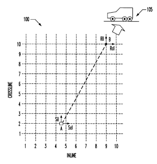
Referring initially to FIGURE 1, illustrated is a plan
view of a volumetric or three dimensional (3-D) seismic
survey system 100. The seismic survey system 100 includes
essentially orthogonal first and second seismic energy
sources Sil, Scl located at a source station A and
essentially orthogonal first and second seismic energy
receivers Ril, Rcl located at a receiver station B. The
seismic survey system 100 also includes a recording vehicle
105 employing a computer, which captures and records
seismic data received by the first and second seismic
energy receivers Ril, Rcl. The computer may also employ
algorithms to manipulate the seismic data. As shown in
FIGURE 1, both source and receiver stations A, B are
positioned with respect to essentially orthogonal inline
and crossline locations collectively designated INLINE 1-10
and CROSSLINE 1-l0. This orientation is commonly called
field coordinate space.
In the illustrated embodiment, the source station A is
located on a CROSSLINE 2 and positioned midway between an
INLINE 4 and an INLINE 5. The receiver station B is
located at the intersection of an INLINE 9 and a CROSSLINE
10. These are arbitrary locations and of course, receivers
at more than one receiver station may be arrayed about the
source station A (typically at inline-crossline
intersections) to receive and record additional reflected
seismic energy in a volumetric seismic survey. The first
seismic energy source Sil is an inline-polarized horizontal
source, and the second seismic energy source Scl is a
crossline-polarized horizontal source. Similarily, the
first seismic energy receiver Ril is an inline horizontal
sensor, and the second seismic energy receiver Rcl is a
CA 02401316 2002-09-04
crossline horizontal sensor. Although not specifically
detailed in FIGURE 1, source station A and receiver station
B also include a vertical seismic energy source Sv and a
vertical seismic energy receiver Rv, respectively.
In the seismic survey system 100, the seismic energy
imparted at the source station A into the subsurface
formations of the earth contains seismic energy modes of
various orientations. Generally, these oriented seismic
energies contain vertical shear waves, horizontal shear
waves, and compression waves. In the field coordinate
orientation of FIGURE 1, the first and second seismic
energy receivers Ril, RcI receive energies from each of
these three modes or orientations that are intermingled
together in a way that complicates data processing and
imaging.
Turning now to FIGURE 2A, illustrated is a diagram of
an embodiment of a seismic exploration system 200,
constructed according to the principles of the present
invention. The seismic exploration system 200 includes a
seismic energy source 205, which provides an associated
support structure 206 for a directional assembly 207
coupled to it. The seismic exploration system 200 further
includes a seismic recorder system 250, which is coupled to
a communication network 230 also associated with the
seismic energy source 205. The communication network 230
is coupled to the seismic recorder system 250 via a source
orientation communication link 234, which is wireless in
the illustrated embodiment.
The communication network 230 is also coupled to the
directional assembly 207 via a direction indication link
233 and employs a direction orientation system 231 having
a direction indicator 232 associated therewith. The
seismic exploration system 200 still further includes first
_g_
CA 02401316 2002-09-04
and second seismic receivers 240A, 2408 that are located on
a terrain where they are positioned in a survey grid having
inline and crossline orientations. The first and second
seismic receivers 240A, 2408 are coupled to the seismic --
recorder system 250 via a seismic data cable 245..
The directional assembly 207 includes a mount 210 that
is coupable to the support structure 206 and a rotatable
mass assembly 215 that is coupable to the mount 210. The
directional assembly 207 further includes a compass rose
IO 220 that is coupled to the rotatable mass assembly 215 and
a direction reference 225 that is coupled to the mount 210,
in the illustrated embodiment. The compass rose 220 is
registered with the direction reference 225 to provide a
direction orientation of the rotatable mass assembly 215
with respect to the mount 210.
Turning momentarily to FIGURE 2B, illustrated is a
plan view 250 of an embodiment of the directional assembly
207 of FIGURE 2A, constructed according to the principles
of the present invention. The plan view 250 shows the
direction reference 225 coupled to the mount 210. The
mount 210 is a stationary cylindrical housing that is
directly coupled to the support structure 206, which is
depicted as a vehicle in FIGURE 2A~. The compass rose 220
is coupled to the rotatable mass assembly 215 in a fixed
arrangement so that rotation of the rotatable mass assembly
215 also rotates the compass rose 220 by a like amount. In
the compass rose 220, angular demarcations of 45 degree
increments are labeled and smaller demarcations
representing ZO degree increments are also shown. A shaft
212, which is concentric with the mount 210, supports the
rotatable mass assembly 215 and the compass rose 220. The
shaft 212 allows them to rotate in either direction with
respect to the support structure 206 and the mount 210.
_g_
CA 02401316 2002-09-04
In the illustrated embodiment, the compass rose 220
includes signal transmitters (not shown) that are located
adjacent an inner circumference. The signal transmitters
..- allow a rotation of the compass rose 220 to be discerned
within one degree of circumference when employed with a
signal receiver (not shown) that is located within the
direction reference 225. The illustrated embodiment
employs an optical positioning arrangement using 360 light
emitting signal transmitters that communicate with a light
sensitive signal receiver to discern rotational position of
the rotatable mass assembly 215. The signal receiver
converts an optical signal received into an electrical
signal. Of course, other signal transmitting and receiving
arrangements such as using wireless electromagnetic or
magnetic energy, mechanical contacts or visual alignments
of rotation are well within the broad scope of the present
invention.
In an alternative embodiment, the compass rose 220 may
be coupled to the mount 210 and the direction reference 225
may be coupled to the rotatable mass assembly 215.
Additionally, the compass rose 220 may include a collection
of signal receivers and the direction reference 225 may
include a single signal transmitter. Or, the compass rose
220 may include a single signal receiver and the direction
reference 225 may include a collection of signal
transmitters. Alternatively, the compass rose 220 may
include a single signal transmitter and the direction
reference 225 may include a collection of signal receivers.
The compass rose 220 may also locate these signal
transmitters or receivers adjacent an outer circumference,
as well.
Returning to FIGURE 2A, the illustrated embodiment
employs a computer and computer monitor for the direction
-10-
CA 02401316 2002-09-04
orientation system 231 and the direction indicator 232,
respectively. The direction indication link 233 is an
electrical cable that is coupled between the direction
reference 225 and the direction orientation system 231.
The direction indication link 231 conveys the converted
electrical signal data from the signal receiver associated
with the direction reference 225 to the direction
orientation system 231 for processing. The indicated
rotational orientation of the rotatable mass assembly 215
is then displayed on the direction indicator 232.
Additionally, the rotational orientation of the rotatable
mass assembly 215 is transmitted to the seismic recorder
system 250 via the source orientation communication link
234 for recording and further processing.
The seismic source 205 may traverse the survey grid in
a crossline direction and may correspondingly orient the
rotatable mass assembly 215 wherein the direction reference
225 corresponds to a crossline direction. Alternatively,
the rotatable mass assembly 215 may be oriented wherein the
direction reference 225 corresponds to an inline direction
or is magnetic north. Of course, the rotatable mass
assembly 215 may be generally oriented wherein the
direction reference 225 corresponds to a discretionary
direction other than crossline, inline or magnetic north.
Also, the seismic source 205 may traverse the survey grid
in a direction other than crossline and orient the
rotatable mass assembly 215 in a discretionary direction,
as appropriate.
In the illustrated embodiment, the seismic recorder
system 250 may request a particular orientation of the
rotatable mass assembly 215 to enhance the response of the
first and second seismic receivers 240A, 240B. This
request may be conveyed from the seismic recorder system
-11-
CA 02401316 2002-09-04
250 through the communication network 230. It is responded
to by an operator of the seismic energy source 205 who then
orients the rotatable mass assembly 215 accordingly. In an
alternative embodiment, the seismic recorder system 250 may
actually control the orientation of the rotatable mass
assembly 215 wherein the communication network 230 is
empowered to directly control the orientation of the
rotatable mass assembly 215.
Turning now to FIGURE 3, illustrated is a plan view of
a seismic survey system 300 showing a transformation in the
horizontal plane of the seismic survey system 100 of FIGURE
1. The seismic survey system 300 includes essentially
orthogonal first and second seismic energy sources Sr, St
located at a source station A and essentially orthogonal
first and second seismic energy receivers Rr, Rt located at
a receiver station B. As shown in FIGURE 3, both source
and receiver stations A, B are still positioned with
respect to essentially orthogonal inline and crossline
locations collectively designated INLINE 1-10 and CROSSLINE
1-10, as before. However, the seismic survey system 300
employs a unique coordinate rotation to transform the
horizontal sources and receivers from the inline and
crossline orientation (field coordinate space) of FIGURE 1
to a radial and transverse orientation (radial/transverse
coordinate space), as shown in FIGURE 3.
This coordinate change employs a trigonometric
rotation of both the sources and receivers as defined by an
azimuth angle OH1. The azimuth angle OH1 is defined as the
angle between the crossline direction and a straight line
formed through the source-receiver station pair A-B, as
shown. in FIGURE 3. This coordinate change is typically
accomplished through manipulation and processing of the
recorded seismic data, preferably with computers and the
-12-
CA 02401316 2002-09-04
appropriate software to accomplish the data manipulation.
One who is skilled in the art would understand how to
program the computer to make the appropriate data
manipulations using the trigonometric function mentioned - -
above. However, this coordinate change may also be
accomplished by physically orienting the sources and
software orienting the receivers as shown in FIGURE 3.
An embodiment of a seismic energy source having a
directional assembly, as discussed in FIGURES 2A and 2B, is
particularly advantageous for use in the radial and
transverse orientation of FIGURE 3. The present invention
thereby facilitates the directing and focusing of shear
wave seismic energy in any direction or azimuth deemed
advantageous at the time that the survey is being
conducted. This capability allows the seismic energy
source to physically provide shear wave energy in the
radial or transverse direction that may be maximized for a
station or collection of seismic energy receivers while
still maintaining an inline and crossline field survey
coordinate situation. Then, an appropriate software
manipulation or orientation of the receiver data would
demonstrate this enhanced shear energy for that receiver
station.
Of course, the seismic energy receivers could also be
physically oriented, but this is often cumbersome and time
consuming in field situations due to the number of
receivers and receiver stations. An embodiment of this
invention employing a seismic source with an easily
oriented directional assembly allows many data gathering
enhancements and test scenarios, especially while in a
field environment.
This rotation is, of course, critical for separating
wave modes in a 3-D multi-component seismic data
-13-
CA 02401316 2002-09-04
acquisition geometry. This coordinate rotation transforms
the seismic data to allow the first receiver Rr and the
first seismic energy source Sr, which are oriented in the
radial direction, to effectively provide a wavefield that
is dominated by compression and vertical shear modes. This
arrangement minimizes interference from horizontal shear
modes. Correspondingly, the rotation also transforms the
seismic data to allow the second seismic energy receiver Rt
and the second seismic energy source St, which are oriented
l0 in the transverse direction, to effectively provide a
wavefield that is dominated by horizontal shear reflections
having minimal interfering compression and vertical shear
modes. This allows further data processing steps to
proceed in a more robust manner.
Turning now to FIGURE 4, illustrated is a flow diagram
of an embodiment of a method 400 of orienting a seismic
source constructed in accordance with the principles of the
present invention. The method 400 includes registering a
compass rose with a direction reference to orient a
rotatable mass assembly of the seismic source with respect
to a mount of the seismic source . Generally, the compass
rose may be coupled to either the mount or the rotatable
mass assembly wherein the direction reference may then be
coupled to either the rotatable mass assembly or the mount,
respectively.
In the illustrated embodiment, the compass rose is
coupled to the mount and the direction reference is coupled
to the rotatable mass assembly. In an alternative
embodiment, the compass rose is coupled to the rotatable
mass assembly and the direction reference is coupled to the
mount. Additionally, the illustrated embodiment includes
registering a signal transmitter coupled to the compass
rose with a signal receiver coupled to the direction
-14-
CA 02401316 2002-09-04
reference. An alternative embodiment includes registering
a signal receiver coupled to the compass rose with a signal
transmitter coupled to a direction reference.
The method 400 begins -in a step 405 wherein
S determination of an intended direction of travel of the
seismic source across the area to be surveyed further
allows determination of an orientation of a support
structure of the seismic source. Then, in a first
decisional step 410, a decision is made as to whether the
orientation of the rotatable mass assembly is to be
registered in a crossline direction. A decision to
register in the crossline direction allows a determination
of the angular rotation necessary to register the rotatable
mass assembly in the crossline direction to be accomplished
in a step 415. Then, in a step 420, the rotatable mass
assembly is rotated by the amount determined in the step
415, thereby orienting it to the crossline direction. The
method 400 then returns to the step 405.
A decision not to register to the crossline direction
in the first decisional step 410 leads to a second
decisional step 425 wherein a decision is made as to
whether to register the rotatable mass assembly in an
inline direction. A decision to register the rotatable
mass assembly in the inline direction allows a
determination of the angular rotation necessary for
accomplishment, in a step 430. The rotatable mass assembly
is then appropriately rotated to the inline direction, in
a step 435. Then, the method 400 again returns to the step
405.
A decision not to register to the inline direction in
the second decisional step 425 leads to a third decisional
step 440. A decision is made, in the third decisional step
440, as to whether to register the rotatable mass assembly
-15-
CA 02401316 2002-09-04
in the direction of magnetic north. A decision to register
in the direction of magnetic north allows a determination
of the angular rotation necessary for its accomplishment,
in a step 445. Newt, the rotatable mass assembly is
rotated to the direction of magnetic north in a step 450.
The method 400 again returns to the step 405.
A decision not to register to a magnetic north
direction in the third decisional step 440 leads to a
decision to register the rotatable mass assembly to a
discretionary direction that differs from the directions of
crossline, inline and magnetic north. For this case, a
determination of the angular rotation necessary to
accomplish registration to the discretionary direction is
accomplished in a' step 455, and orientation of the
rotatable mass assembly is accomplished in a step 460. The
method 400 returns to the step 405.
In summary, a seismic energy source having a
directional assembly, as described above, facilitates an
initial transformation of seismic data into a
radial/transverse coordinate space. This is especially
advantageous along a corridor of receiver stations wherein
the separation of vertical and horizontal shear mode
energies is advantageous. This transformation and
separation may also facilitate the identification of
subsurface structures of interest such as those that may
result from an anisotropy.
Although the present invention has been described in
detail, those skilled in the art should understand that
they can make various changes, substitutions and
alterations herein without departing from the spirit and
scope of the invention in its broadest form.
-16-