Note: Descriptions are shown in the official language in which they were submitted.
CA 02406946 2002-10-11
WO 021065331 PCT/CA112/00144
Information Retrieval System And Method Employing Spatially Selective
Features
Field of the Invention
The present invention relates generally to information retrieval
systems, and more particularly to an information retrieval system and method
employing spatially selective features.
Background of the Invention
Although location is a fundamental, unifying principle humans use to
organize their "spatial awareness" of the world, the Internet has failed to
deliver high performance spatial search and retrieval capabilities.
Traditional means of finding local content have included reading the
local newspapers, searching telephone yellow page directories, listening to
the radio, spotting billboards, and seeing local TV announcements or
advertising. On the Internet today, some local content can be found using
'yellow page' listing services, city content sites, local portals and ISPs.
However, these services offer limited geographic scope and focus
mainly on large metropolitan areas. While all of these content sites provide
elements of useful information, what is needed is a method to provide a
continuum of data across the entire world, and across all categories. As well,
it would be advantageous to enable average users to add local content to
these databases.
Quickly and easily finding local content on the Internet today is a
laborious, convoluted, and inconsistent experience. Internet users are
CA 02406946 2002-10-11
WO 02/065331 PCT/CA02/00144
2
typically required to provide specific Zip code, or other positional
information
to conduct a search for local content.
Furthermore, in order to find any specific local content, the user has
been required to enter a known geographic, postal, or street address to
commence a search. This inhibits a user in performing 'real-world' searches
where one might not know an address or postal code. A system for finding
local content at any point within an international geographic extent has not
been possible.
Current Intemet mapping and local search capabilities are limited to
static data, and are restricted to a delimited geographic area, such as a
country, and do not provide an optimal geo-location search range for each
record. Typically, searches on the Internet are performed by selecting a pre-
determined classification of information by sub-category(s). The problem is
that the resulting size of the search catalogues often requires time-consuming
scanning by users through a myriad of categories and/or a large amount of
irrelevant results.
Geographic Information Systems (GIS) have, for many years, provided
tools to generate, manipulate, and manage spatial data. Governrrment
agencies and commercial data vendors use GIS extensively to create and
maintain map data used by location services. Vendors provide street-
centerline data sets that include address and street name data, which are
essential to geo-coding and routing applications. Location services that
incorporate GIS tools enable a wide range of spatial transactions that can be
delivered in meaningful ways.
Some commercially available database management systems (DBMS)
currently include basic spatial data management capabilities, providing
limited
support to location services. DBMS's specialize in the storage and
CA 02406946 2002-10-11
WO 02/065331 PCT/CA02/00144
3
management of all types of data including geographic data, and are optimized
to store and retrieve data. Although many GIS's rely on DBMS's for this
purpose, they are not competitive in terms of performance, flexibility, and
scalability without direct access to a robust GIS at their foundation.
Distributing geographic information via the Internet enables real-time
display and integration of data from around the world. A natural extension of
a
traditional desktop GIS, Intemet mapping and associated applications have
been popularized by various sites that deliver maps to the end user via a
browser. However to date, mapping on the Internet has been mainly a
cartographic exercise, with minimal capability for true information searching
and adding of new content.
Computer desktop mapping systems use the map paradigm to
organize data and user interaction. The focus of such systems is the creation
of maps, with the map linked to a database containing related information.
However, most desktop mapping systems have limited data management,
spatial analysis, or customization capabilities.
Computer Aided Design (CAD) systems have evolved to create
designs, and buildings plans. CAD systems require that components with
fixed characteristics be assembled to create the whole structure. These
systems feature few rules to specify how components can, or should be,
assembled and include very limited analytical capabilities. Although some
CAD systems have been extended to support maps, they typically have
limited utility for managing and analyzing large geographic databases.
Remote sensing is the art and science of making measurements of the
earth using sensors such as GPS receivers, or cameras fitted to aircraft or
sateliites. These sensors collect data in the form of images and data streams
CA 02406946 2002-10-11
WO 02/065331 PCT/CA02/00144
4
and include specialized capabilities for manipulating, analyzing, and
visualizing those images.
For the foregoing reasons, there is a need for an improved information
retrieval system and method.
Summary of the Invention
The present invention is directed to an information retrieval system and
method employing spatially selective features. The system includes a search
interface, a map interface, a results table interface, and a Lasoo tool for
selecting a search area. The method includes the steps of providing a search
interface, providing a map interface, providing a results table interface, and
providing a Lasoo tool for selecting a search area.
In an aspect of the present invention, roll-out map controls are provided
to optimize the use of limited display space; view finder control to provide a
panning function to the map; and custom spatial driving directions to display
a
list of routes on the map. In an aspect of the present invention, a geo-
enabled
messaging and conference module is provided to apply spatial characteristics
to each member of a conference or messaging service, and to enable the
members to selectively communicate with other members.
The invention removes the barriers to finding local content quickly and
easily. The invention solves the problem of requiring specific postal code or
other positional information in order to conduct a search for local content by
providing simple 'point and click' entry to begin a search anywhere in the
World. The invention provides scalability and reliability, delivering
comprehensive, targeted and customizable geo-coded local content, based
on a user's actual or preferred location anywhere in the World, to any wired
or
wireless Internet device.
CA 02406946 2009-03-09
4a
In one aspect of the invention, an information retrieval method is
described. The method includes the steps of storing geo-coded records in a
database, receiving a search location, a search request, and a geo-spatial
search
range, and locating search results within the geo-spatial search range from
the
set of the geo-coded records relevant to the search request. If no search
results
are located in the geo-spatial search range, the method includes the further
steps
of automatically determining a geo-spatial distance from the search location
needed to locate a specified number of search results from a set of geo-coded
records relevant to the search request and extending the geo-spatial search
range
to the determined geo-spatial distance, and retrieving the specified number of
search results.
In another aspect of the invention, an information retrieval system is
described. The system includes a database for storing geo-coded records, an
interface for receiving a search location, a search request, and a geo-spatial
search range, and an extended range record module for locating search results
within the geo-spatial search range within the geo-spatial search range from
the
set of the geo-coded records relevant to the search request. If no search
results
are located in the geo-spatial search range, the system also includes an
auto-range determination module for automatically determining a geo-spatial
distance from the search location needed to locate a specified number of
search
results from a set of geo-coded records relevant to the search request and
extending the geo-spatial search range to the determined geo-spatial distance
and a search engine for retrieving the specified number of search results.
CA 02406946 2002-10-11
WO 02/065331 PCT/CA02/00144
Other aspects and features of the present invention will become
apparent to those ordinarily skilled in the art upon review of the following
description of specific embodiments of the invention in conjunction with the
5 accompanying figures.
Brief Description of the Drawings
These and other features, aspects, and advantages of the present
invention will become better understood with regard to the following
description, appended claims, and accompanying drawings where:
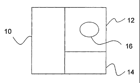
Figure 1 is an overview of an information retrieval system employing
spatially selective features according to an embodiment of the present
invention;
Figure 2 is an overview of an information retrieval method employing
spatially selective features according to an embodiment of the present
invention;
Figure 3 illustrates a user interface according to an embodiment of the
present invention;
Figure 4 illustrates an example of a Micro-Map;
Figure 5 illustrates the wireless use of the application;
Figure 6 is a simplified overview of logical architecture according to an
embodiment of the present invention; and
Figure 7 is an overview of the system according to an embodiment of
the present invention.
Detailed Descripfion of the Presently Preferred Embodiment
The present invention is directed to an information retrieval system and
method employing spatially selective features. As illustrated in Figure 1, the
system includes a search interface 10, a map interface 12, a results table
CA 02406946 2002-10-11
WO 02/065331 PCT/CA02/00144
6
interface 14, and a Lasoo tool 16 for selecting a search area. As illustrated
in
Figure 2, the method includes the steps of providing a search interface 100,
providing a map interface 102, providing a results table interface 102, and
providing a Lasoo tool 104 for selecting a search area.
Search Interface
A Polygon Search Module (PSM) that enables the definition and
storage of any geo-spatial polygon, comprising an unlimited number of 'sides'
to the polygon, defined by the applicable latitude and longitude co-ordinates
of
each 'side'. The PSM can be used to define a search area for any point
located within the boundary of the polygon.
The PSM includes an Automatic Clipping Engine (ACE) that produces
a radial search area, based on the current search position and search range,
within which the polygon is a geo-spatial sub-set, then automatically removes
or'clips' any results that lie outside of the polygon, whenever a search based
on the defined PSM is made, subject to extension of the searchable area
using a Dynamic Search Range Module (DSRM), as described below. The
PSM extends the search algorithm of the standard radial search to any geo-
spatial polygon, such as any area, region, state, or country.
The invention includes an ability to create maps based on a given
longitude/latitude or a city, Zip code, state, or country. Search results are
provided in tabular format with a linked map, along with a platform to allow
users to add information to a geo-referenced database. All information within
the application's database should be tied to a precise longitude and latitude
and can be displayed on a variety of scaled, electronic maps over the
Internet.
A Dynamic Categories Module (DCM) creates a dynamic set of
categories to present to the user dependent on the current map setting. The
CA 02406946 2002-10-11
WO 02/065331 PCT/CA02/00144
7
DCM automatically identifies any non-populated categories for the current
map setting. In addition, the DCM performs a spatial count of records within
each qualifying category that are encompassed by the current map setting.
Thus the user is presented with a qualified list of Categories relative to the
specific map setting and each qualified category in the tree structure is
displayed along with the number of valid records contained within that
Category, where the number shown is inclusive of any 'child' category
records.
The DCM provides the principle advantage that the end-user is
presented with a manageable, relevant set of categories, as opposed to a
much larger, less relevant list, for the map setting that the user has
currently
selected; thus, making searching much quicker and more effective. Whenever
the user selects a new location to begin a search, the DSRM geo-spatially
evaluates all data surrounding the specified location, and automatically
determines an appropriate default search range to provide search results for
this location and range, in all appropriate categories.
In addition, the DSRM is utilized whenever a keyword search is
invoked. The DSRM ensures that relevant results are retumed, provided
relevant data exists at some location geo-spatially. The DSRM ensures the
l'ocation of the closest set of search results to the user's specified
location, no
matter what location and range was initially specified by the user for the
search.
An Internet Database Link Control Module (IDLCM) takes database
content from any DBMS and automatically enables access via the Internet to
the information contained in that database, through auto re-direction of
search
requests emanating from any Intemet search engine. The IDLCM
automatically directs search requests for any directory listing or category to
a
local search results page for the desired location and category/reference by
CA 02406946 2002-10-11
WO 02/065331 PCT/CA02/001-14
8
means of an IDLCM result link displayed to the user within the search
engine's result list. The IDLCM produces this functionality by automatically
creating a specific Web page with imbedded mega-tags and other information
for each record in the set of records that the database manager wishes to
make Internet accessible.
The software automatically directs search requests from any Internet
search engine for any search related to the key or index value of a record
from the Internet linked database. The IDLCM enables any search engine to
create a suitable reference link to the desired database record, enabling the
automatic display of this link reference within the search engine's result
list.
The reference link itself, on the search engine's results list, emanates from
the
search engine having scanned and indexed the automatically generated
database engine stored by the IDLCM on a Universal Resource Locator
(URL) and set of Web pages specific to the target database and record. As an
example using this methodology, a database of local content information can
be provided to all Internet search engines automatically, with the end-user
being linked to a relevant site where local content information and
appropriate
GIS tools are available.
The map frame is where the search location, range and result points
are displayed and configured. The display of a Lasoo provides an intuitive
range ring on the map. The Lasoo defines the spatial proximity component of
a search and is a circle placed on a map with a center, (x, y), and a radius,
r.
The system displays multiple results on the map as a set of independent
'dots', including a feature that accumulates overlapping results into one
'dot'
but enables a user to select from a pop-up window displaying records
belonging to the 'dot' when the user clicks on the 'dot'.
In addition, this interface area provides important navigational and
search criteria controls such as zooming controls, a location finder or
CA 02406946 2002-10-11
WO 02/065331 PCT/CA02/00144
9
"gazetteer", range or Lasoo' size control, a viewfinder for fine-tuning
current
location, 'center Lasoo' control, 'place Lasoo' control, and map panning
control. Searches are conducted using detailed, high quality, worldwide maps
featuring zoom levels down to street-level and a worldwide gazetteer offering
city and place names worldwide. The invention automatically links a geo-
coded information database with associated Internet Web pages, and
provides integrated search and retrieval of information from database and
Web simultaneously.
In an embodiment of the present invention, search queries can be
initiated either through a direct keyword input or by clicking on any category
item. A search query can be conducted either through user keyword input or
by selecting from a customized, 'clickable' category tree. Only populated
categories appear. Searching can be performed within an information
directory and/or a web site.
An Auto Range Determination Module (ARDM) that automatically
detects the minimum range (geo-spatial distance) that needs to be set in
order to locate and retrieve a minimum, specified number of search results,
for a particular set or classification of records stored within a geo-Iocated
database, where each record has latitude and longitude attributes. The ARDM
is input with the location in latitude and longitude setting, where the search
is
to commence.
Options within the DCM permit non-populated categories to be omitted
from the category search tree or to be presented as 'grayed out', with the
further option that unselected categories, if chosen will use the ARDM
function to retrieve record(s) for this category by automatically extending
the
search range appropriately.
CA 02406946 2002-10-11
WO 02/065331 PCT/CA02100144
In an embodiment of the present invention, the Search Interface further
includes an Extended Range Record Module (ERRM) that provides geo-
spatial indexing of records beyond a standard containment area and allows
for the search and retrieval of such a record for a geo-spatial search
5 commencing at a point and for a range beyond the standard search area
availability of the record.
Typically, a search is based on a location and search range or
distance. This procedure defines a local content search for information such
10 as businesses and organizations located within the defined search zone. The
extended range attributes for any single record can be set and the ERRM will
ensure that the record will appear within appropriate geo-spatial searches
using any location and range, from 1 meter to worldwide.
However, there are important instances where information and/or
records should be 'searchable' for search locations and ranges that do not
contain the physical location the information record is tied to. For instance,
a
Florist A may want to market flowers to anyone searching/residing within a 50
km radius of his store location. If someone was 35 km distance and searching
for Florist shops within a 10 km radius, then such a search would not contain
Florist A. If one searched within 5 km for a local pet shop and none was
found, the invention automatically extends the search further for you until
one
or more records are found, or a pre-defined threshold has been reached.
In an embodiment of the present invention, a Dynamic Filter (DF)
automatically senses a user's profile depending on the user's preferences, the
user-specified category filter class, and the category structure returned by
the
DCM. The category filter class is one of several pre-established sub-sets of
the master category structure designed by the system architect to reflect the
category interests of specific groups. The DF ensures that all of the user's
settings and preferences are applied to the DCM to produce a dynamic, fully
CA 02406946 2002-10-11
WO 02/065331 PCT/CA02/00144
11
customized set of categories for searching based on the current user's map
setting.
The parameters of the DSRM can be dynamically altered at the
moment the module is invoked, to match the user's preferences in terms of
categories of most interest. DSRM parameters can be adjusted to specify
range limits and minimum returned result set. In addition, the user may create
as many favorite folders" within which can be recorded details of the current
search the user has performed, including retention of specific record result
details, all of which can be used to automatically search and retrieve
relevant
data in future search sessions.
"Cookie" technology can be employed to provide a powerful, more
personalized experience by storing information about an individual user's
preferences and previous choices. For example, a cookie could hold keyword
or category searching criteria and/or user search location information,
enabling a business to customize and target delivery of information and
advertisements. The invention enables the easy customization of mapping
icons and/or the prioritization of results to reflect specific business
promotions
and sponsor needs.
In an embodiment of the present invention, the search interface
includes a circle for indicating the area to provide information about. In an
embodiment of the present invention, multi-colored circles are provided with
equidistant placed concentric rings to form a 'bulls eye' style target, or
"Lasoo". Each colored ring forms a concise geographic selection area that
increases in physical area as the radius increases. Results found in a
particular query appear as dots within these rings.
CA 02406946 2002-10-11
WO 02/065331 PCT/CA02/00144
12
Map Interface:
A semi-transparent target (STT) is imbedded within each map to
provide a visual reference for the user that graphically outlines the search
area the user has selected and provides a visual reference for multiple result
points that are automatically positioned on the map, so that the user can
easily determine visually their relative distance from the center of the
search
location as well as their distance from each other. The semi-transparent
aspect of the STT enables all of the underlying and overlying map details to
be readily distinguished. The STT records current geo-position for the device
or that selected by the user, along with the currently selected or determined
search range, dynamically feeding this data to other software objects.
An STT Automatic and Dynamic Positioning Module (STTAPM) is
included to enable a user to click anywhere on the map display to
automatically reposition the STT to a point indicated by a mouse pointer. The
STTAPM also automatically repositions the STT whenever the user selects a
new location from within the gazetteer, or selects a previously used location.
The resulting symbol, typically a dot on the map is evaluated using a
Boundary-Subset Module (BSM) to determine if one or more result points will
overlap, causing visual confusion and deterioration of data communication to
users. If such a case arises, an incorporated optimizer will select points to
combine in order to eliminate overlaps, and size the resulting point to a
larger
dimension to visually reflect that it represents more than one point.
A detailed page 'pop-up' is provided for any resuit whenever a user
clicks on the applicable record in the results list or on the corresponding
'dot
on the map, without altering the underlying map/results list display. The page
pop-up includes a street-level location map showing the precise location of
the record, address and contact information; links to the corresponding Web
CA 02406946 2002-10-11
WO 02/065331 PCT/CA02/00141
13
page where applicable, and other text and information, which a record owner
may add.
The BSM's parameters are fully adjustable to suit design parameters
pertaining to spacing requirements and aesthetics. Since the entire module
set is re-computed as a map is drawn, panning, zooming, and/or relocation of
map data results in a dynamic re-assessment of the position and size of a
map result points.
As illustrated in Figure 4, in an embodiment of the present invention, a
Micro Mapping Module (MMM) links CAD files or scanned images with geo-
spatial positioning controls and map link controls, to provide an integrated
view of the interior of buildings and/or high-definition mapping for precise
areas such as shopping centers, exhibit centers, fair grounds, manufacturing
plants, and park grounds. The MMM enable the precise location of any object
or position on the micro map to be determined and displayed to the user. The
MMM link control enables a micro map to be integrated within a standard
digital street level display, so that a user has a seamless means of 'drilling
down' from the digital street map to within the micro map.
In addition, micro map zoom/pan controls enable zooming and panning
within the micro map in a completely analogous manner to the zoom/pan
controls for the standard digital maps. A11 map controls such as zoom, pan,
range, and location utilize a unique rollout feature called Rollout Map
Controls
(RMC). When a user clicks on the applicable control, an expanded control
feature list window appears to the side of the control. The user can then
select
from among the expanded list of available features for that control This
technique optimizes the use of limited display space and at the same time
offers a full set of expanded features without the need to refresh a screen
display, since the roll-out control and its embedded feature display list are
downloaded and instantly available from the main page the control sits on.
CA 02406946 2002-10-11
WO 02/065331 PCT/CA02/00144
14
A View Finder control provides a unique means of panning a map. The
'viewfinder' tool enables a user to pan the main map by moving the viewfinder
over a rollout index map that features a much larger geographical area than
that of the main map. The user moves the viewfinder by pointing and clicking
to the new desired position of the viewfinder. At the same moment as the
viewfinder moves on the underlying index map, the main map in the map
pane refreshes to show the new map determined by the viewfinder control's
new position. The map 'viewfinder' tool enables a user to pan the main map
by moving a viewfinder control on a rollout index map that features a much
larger geographical area than that of the main map.
A Custom Spatial Driving Directions Module (CSDDM) enables the
owner of a database record to record customized driving directions onto a
street-level, or other zoom level, map display by specifying a series of
linked
points on the map simply by clicking with the mouse pointer at the applicable
places on the map. The series of linked points then becomes a 'route' on the
map. Routes can then be rated according to type, such as quickest, scenic, or
walking route.
In addition, the CSDDM enables the addition of descriptive text by a
database record owner in an adjacent text box; explaining the route and
adding other useful end-user information. The CSDDM enables the addition of
any number of custom 'driving direction' routes to a map, and to store these
custom routes with the applicable database record(s). Further, the CSDDM
provides an end-user interface for selecting from a list of routes, as
illustrated
in Figure?
In an embodiment of the present invention, a Geo-enabled Messaging
and Conference Module (GMCM) is included that automatically applies spatial
characteristics to each member of a conference or messaging service and
CA 02406946 2002-10-11
WO 02/065331 PCT/CA02/I)0144
enables members to selectively communicate with other members within the
STT the user has defined. In this manner, members may view the locations of
all members, or any desired geographical sub-set of members, on the map
display and select on a geo-spatial basis which communications to process.
5
Results Table Interface:
The Results Table Interface (RTI) displays the search results in a table
format. Each result found in the table is linked to a specific record point
(dot)
10 on the map. A user may inspect results by either rolling over a record
within
the Results Table or by rolling over a record point on the Map. Either
procedure will yield a colored 'hot-link' between the mapped result and the
table result for a specific record. Displays search results in a list and
multi-
point map format simultaneously.
Any selected result record occurring in a search area on the map, or
'Lasoo', appears in a Results Table below the map. The results table is color-
coded depending on the color Lasoo ring in which a resulting dot is found.
Results are displayed normally from nearest to farthest from a Lasoo center.
The Results Table further features symbology associated with additional
information for each record in the table, a distance field, a listing of the
radial
distance from Lasoo center, extended range records, directory/search
category labels, 'Next' and 'Back' table review controls, hot-linked row click
launch, a hot-linked 'roll-over' map highlighter.
A Dynamic Search Results Updating Module (DSRUM) is included for
creating automatically updated search results based on the current position of
the STT as the user moves or re-sizes the STT controls within the map pane.
Whenever a user places the STT in a new position or re-sizes the range of the
STT, the DSRUM performs an automatic background update of the search
results, and automatically refreshes the search results list.
CA 02406946 2002-10-11
WO 02/065331 PCT/CA02/00144
16
In an embodiment of the present invention, a user can sort the list
according to several alternative criteria. Enables the user to sort the search
results by several criteria, such as distance, category, and name.
In an embodiment of the present invention, a Linked, Rollover Map/List
Search Result Highlighting function provides a feature that when a user rolls
over a result dot on a map, or a result row on the Results List, the result
dot
and row is highlighted. A Roll-out Thumbnail Map & Information (RTMI)
function automatically produces a 'thumb-nail' map and other text information
related to a result row, and displays this information to one side of the
result
row whenever the user 'rolls-over' the row with the mouse pointer. This
function operates in real-time and is independent of the number of result rows
in the results table. The thumbnail map shows the precise street-level map
view associated with the address in the applicable result row.
A rollover function enables a user to identify visually the location of any
result by 'rolling over' either the result on the result list or by placing
the
pointer over a result'dot' on the map. The item being rolled-over
automatically
highlights by changing color, on the map and the results list simultaneously.
A
rollover, information expansion function automatically displays additional
information for a result whenever the user rollovers the corresponding 'dot'
on
the map or the row in the results lists. Additional information displayed to
the
side of the results lists may include a thumbnail street-level locator map,
and/or Web link information.
As illustrated in Figure 5, in an embodiment of the present invention,
the system/invention can also be used in a wireless environment. The GUI
implementations will vary depending on wireless device specifications and
bandwidth. Maps are incorporated on devices with higher resolution displays.
A keyword search and location can be inputted or both can be determined
CA 02406946 2002-10-11
WO 02/065331 PCT/CA02/00144
17
automatically by links to the wired and use of wireless location technology.
Using a Street Intersection Locator, specifying a street intersection can
identify a Lasoo or using auto-location technology that enables usability for
resource limited wireless devices. In an embodiment of the present invention,
a wireless application can use a Smart Street ID to return a short list of
eligible street intersections for a user to select the desired item. Results
are
displayed in a scrollable list, sorted by distance from the center of the
Lasoo.
In an embodiment of the present invention, the invention delivers
locally targeted advertising and information according to any specific
location
and/or demographic profile employing geo-location ad serving. In an
embodiment of the present invention, the invention can automatically store
and retrieve user preference information, such as selected location and
search criteria, and enables users to modify preference data, dynamically
filters categories not present in mapping area, and dynamically modifies
category information presentation based on user selectable filters. The
invention dynamically extends the searchable range of any individual record in
a geo-coded database, enabling users to automatically locate records outside
their specified search range that nevertheless have a logical locai presence
within a specified search range.
In an embodiment of the present invention, the invention enables
database record owners to create date/time sensitive billboard "notes" that
are
automatically displayed in local content search results. Automatically
provides
a geo-coded, searchable, web-page presence for all businesses and
organizations in all major countries and markets worldwide. Enables record
owners to enhance the display characteristics and content of their record(s)
within a geo-coded database.
In an embodiment of the present invention, the invention provides
seamless integration of wired and wireless capabilities, including automatic
CA 02406946 2002-10-11
WO 02/065331 PCT/CA02/00144
18
delivery and configuration of information to wireless devices, along with
automatic detection of wireless device type. Integrates seamiessly with
automatic location determination capabilities of a wireless device, to
automatically deliver location specific results and information to end-users.
Automatically generates demographic profiling data by any user-defined
region woridwide, greatly enhancing direct marketing capabilities while at the
same time adhering to enhanced levels of privacy controi.
In an embodiment of the present invention, the invention provides map
navigation rollout controls that provide reduced display area footprints.
Provides user controlled map functions enabling users to enhance and update
map information for private or public use. The invention provides map
functions and filters that enable users to select map display type, such as
topological, vegetation, or interest-oriented.
Users can define desired search location by simply clicking on a map
or choosing from drop-down list controls without requiring any typing. The
invention searches and finds information records and their associated Web
sites using a single, simple search interface. Searches are performed by
advanced keyword combinations and provide an ability to perform "multi-tier"
searches, wherein searches within searches are performed automatically.
In wireless embodiments of the present invention, the system further
includes a Dynamic Location Sensitive Auto Search Module (DLSASM) for
automatically re-configuring the position of a user's STT on a wireless device
as the user's position changes while the wireless unit is being transported.
The automatically repositioned STT includes a refreshed set of characteristics
and attributes derived from other features and modules.
In wireless embodiments of the present invention, a Wireless
'Automatically Configured Search Module (WACSM) enables a user to
CA 02406946 2002-10-11
WO 02/065331 PCT/CA02/00144
19
configure a local search engine to conform from a user's wired desktop
browser to the characteristics of a wireless device. Further, the WACSM
automafically downloads this configuration information, along with the user's
search preferences to the wireless device whenever the user activates the
wireless unit.
In an embodiment of the present invention, in order to facilitate local
searching, a Spatial Information Favorites Module (SIFM) permits users to
record their favorite search locations, by having the system memorize a
currently selected location on the map or from the gazetteer.
Adding new information to the lnternet has been a bureaucratic and
often intimidating process for most Internet Users and is normally associated
with a fee. The invention enables users, including private individuals,
businesses and organizations, to add new content to the Internet by simply
clicking on a map and posting their own information. Coupled with this is an
ability to have a calendar and/or bulletin board feature associated with an
entry.
The invention includes an integrated wired and wireless geo-spatial
search solution, including a capability to automatically 'load' a wireless
device
with data, set-up and user preference information defined and obtained from
the wired side. This enables a user to employ both wired and wireless
Internet-capable devices to conduct geo-spatial searches. The invention
enables the delivery of information targeted to specific locations and
demographic profiles, using the invention's client positioning capabilities,
regardless of how or where the client accesses the Internet.
Figure 6 Illustrates a simplified overview of the logical architecture for
the system. The "Geocoding Service" is responsible for converting a
conceptual location specification, such as street address, into a precise
CA 02406946 2002-10-11
WO 02/065331 PCT/CA02/00144
longitude/latitude value, which in tum can be used to form a mapping/search
request that is centered on that value. The uMapping Service" provides the
list
of points that are plotted over the background map based on their proximity to
a point of interest and other attribute criteria, such as datum category or
5 similarity to a search string. The "Lasoo Template Engine" and the
appropriate
template are responsible for delivering an interactive interface, including
the
plotting of points over the map image backdrop. Figure 7 illustrates an
overview of the system.
10 The invention provides detailed mapping and local content capability
worldwide, including the unique ability to specify a dynamic adjustable search
range for each individual geo-located record. The invention's dynamic
category/content filtering capabilities enable the presentation to an end-user
of solely the sub-set of categories and content relevant to the user's
specified
15 search criteria and search location.
The invention enables search engines the world over to be
automatically geo-location/local content enabled by virtue of the capabilities
of
the IDLCM. The invention provides for user insertion and modification of geo-
20 coded content within a worldwide Internet searchable database, and enables
users to specify a precise search location without requiring address
information. The invention enables users to create and deploy advertising and
information banners/announcements to targeted, local audiences, anywhere
in the world. In experimentation, the system was able to searches and find in
excess of 10,000 records spatially in less than 0.5 seconds, providing a very
fast result.
The invention removes the barriers to finding local content quickly and
easily. The invention solves the problem of requiring specific postal code or
other positional information in order to conduct a search for local content by
providing simple 'point and click' entry to begin a search anywhere in the
CA 02406946 2002-10-11
WO 02/065331 PCT/CA02/00144
21
World. The invention provides scalability and reliability, delivering
comprehensive, targeted and customizable geo-coded local content, based
on a user's actual or preferred location anywhere in the World, to any wired
or
wireless Internet device.
Although the present invention has been described in considerable
detail with reference to certain preferred embodiments thereof, other versions
are possible. Therefore, the spirit and scope of the appended claims should
not be limited to the description of the preferred embodiments contained
herein.