Note: Descriptions are shown in the official language in which they were submitted.
CA 02411138 2002-11-05
-1-
LOCATING SYSTEM AND METHOD
FIELD OF THE INVENTION
The invention relates to tracking systems that use a radio positioning system
such as
GPS information and wireless radio communications such as cellular telephone.
BACKGROUND OF THE INVENTION
There are systems that involve a tracking function performed by a centralized
and
stationary unit. Examples of such systems are shown in U.S. Patent Nos.
5,594,425;
5,312,618; and 5,043,736. In the usual case, a target's location information
is
transmitted to a monitoring station where the information is processed and
actions
taken accordingly. A variation to this is shown in U.S. Patent 5,389,934 which
allows
the searcher/controller to be mobile; where in one embodiment the system
described
is a rover which when called by a telephone would become active, relay a voice
description of its location and then become inactive; and another embodiment
provides an arrow visual to point in the direction of the target, but does not
take
advantage of the specific spatial relationship calculations used in the
present invention
SUMMARY OF THE INVENT10N
The invention resides in a system for locating and tracking at least one rover
unit from
a mobile controller unit, where the mobile controller unit has a radio
communication
device and a GPS module and the rover has a radio communication device and a
GPS
module, the controller being programmed to receive GPS position information
from
the rover unit by way of the radio communication device and using its own GPS
module, calculate the relative position and bearing of the rover unit, and
using a
display on the controller unit showing a relative bearing, distance and
altitude
difference, or alternatively, map positions of the controller and the rover
using
available map data. The radio communication module is preferably a cellular
telephone. A compass is optionally provided in the controller to provide a
direction
indication to the rover unit.
CA 02411138 2002-11-05
-2-
The controller unit allows the user to select from displayed options, a
selected rover
from a stored directory of rovers to activate a "FIND" process to obtain the
selected
rover's GPS position relative to the controller's GPS position. Also, the
rover unit
has a stored history of positions of the rover units) so that a historical
trail of the
rover's positions can be sent to the controller and displayed. Also, selective
alarms
may be programmed from the controller, into the rover so that when the rover
violates
the alarm limit, the rover automatically signals the controller and the
display shows
the rover's selective or absolute position, along with a signal as to the
basis for the
alarm. Alarms may be spatial such as a boundary or radius passed or may
activate at
a velocity limit, if the rover starts to move faster that the alarm limit.
Also, the rover
may be equipped with a manually activated alarm to signal the controller.
Thus the invention has as one use for keeping in touch with children,
periodically
determining a child's location or trail of movement, or alarm limit violation.
While use of GPS is described above, other radio positioning systems can be
used.
These include GALILEO, GNSS, LORAN, GLONASS and others.
BRIEF DESCRIPTION OF DRAWINGS
Fig. 1 shows a controller unit operational diagram.
Fig. 2 shows the rover unit operational diagram.
Fig. 3 is a flow chart of the controller start procedure.
Fig. 4 is a flow chart of the phone start procedure.
Fig. 5 is a flow chart of the phone memory procedure.
Fig. 6 is a flow chart of the find memory procedure.
CA 02411138 2002-11-05
_y_
Fig. 7 is a flow chart of the find procedure.
Fig. 8 is a flow chart of the find detail procedure.
Fig. 9 is a flow chart of the process GPS messages procedure.
Fig. 10 is a flow chart of the process remote messages procedure.
Fig. 11 is a flow chart of the process user input procedure.
Fig. 12 is a diagram of an interactive home screen.
Fig. 13 is a diagram of an interactive phone screen.
Fig. 14 is a diagram of an interactive manual phone screen.
Fig. 15 is a diagram of an interactive find screen.
Fig. 16 is a diagram of an interactive find detail screen.
Fig. 17 is a diagram of an interactive map screen.
DETALLED DESCRIPTION
The method and apparatus of the present invention is intended, as a primary
application, to enable a person to find a valuable asset which could be a
person, upon
command and to high precision. An exemplary purpose is such as to enable a
parent
to find a child.
The system is comprised of a personal hand held unit (controller), and a
small,
compact, and cancelable unit (rover). Each controller unit gives the user the
ability to
ascertain the precise location of one or more rover units. In addition to all
the
CA 02411138 2002-11-05
-4-
functions and features of the system as described herein, the system is unique
in that
each controller unit is a self contained, mobile unit that can provide to the
user all the
real-time information necessary to locate and find any rover.
The controller unit comprises several primary sub-components including a radio
communication module such as a cellular telephone module, a radio positioning
receiver/processor module such as a GPS receiver/processor module, an
electronic
compass, a display, a computer and associated electronics to operate it. The
controller provides three distinct and interactive and useful functions.
First, the
controller unit is a fully functional cellular telephone with all the typical
functions and
features. Second, the controller unit can display it's own position and the
position of
a rover unit on a street map. Third, the controller unit provides the relative
location of
any rover using the controller unit as the center and displaying a bearing
arrow.
To operate the system as a locator for a rover, the user selects the FIND
feature on the
controller screen. The screen displays all the pre-programmed rover names and
location addresses such as cellular telephone numbers. The user selects a
specific
desired rover and touches GO on the interactive screen. The controller unit
opens
communication with the rover unit by cellular telephone. Using each unit's GPS
module, the controller unit determines it's spatial relative relationship with
the rover.
In one display mode, the controller unit displays the rover unit's location on
a street
level map, which is capable of zooming and scrolling. Through continuing data
from
the rover unit, the rover unit's position is tracked on the map as GPS
information is
sent from the rover unit to the controller unit. In another display, the
relative bearing
location of the rover unit relative to the controller is displayed as an arrow
accompanied by information. In order to obtain use of this arrow feature, a
heading
for the controller unit has to be established. Heading can also be established
on an
initiation basis by use of a compass without movement. As is well known, GPS
can
only provide heading when the receiver is moving and receives sequential
movements
from the GPS satellites. The arrow displays the bearing of the rover relative
to the
controller taking into account the location of the rover unit, the location of
the
CA 02411138 2002-11-05
controller unit, and the heading of the controller unit based on it's GPS and
optional
digital compass data. The information displayed along with the arrow
preferably
includes controller unit to rover unit distance, rover unit velocity, rover
unit height
relative to the controller unit, the time at which the rover unit's data was
ascertained
and the rover unit's coordinate system location such as latitude, longitude
and
elevation. The arrow display is used primarily when the controller unit and
the rover
unit are relatively close, such as in a neighborhood, where a directional
arrow is
useful for the controller unit user. To implement these displays, the
controller unit
receives GPS data, which provides the relative spatial relationship of the
controller
unit and the rover unit to high precision, as good as 1 meter accuracy. In
order to
achieve this precise relative spatial relationship, the rover unit and the
controller unit
gather and share GPS measurements of pseudorange and carrier phase from the
same
GPS satellites. Much of the error in GPS positioning occurs due to errors that
are
common to the two receivers making measurements close in time and space.
Therefore, having knowledge of the two receiver's GPS measurements allows for
removal of the common errors and consequently, a precise calculation of the
relative
spatial orientation of the two units as well as good knowledge of the units'
absolute
position. Optionally, the bearing and distance information can be presented in
an
audible fashion.
The methods and apparatus to obtain the high precision relative position
between the
rover unit and the mobile controller unit may be implemented using known
technique
with GPS. When the rover and controller are fairly close together, their
satellite suite
reception is likely to have great overlap, perhaps even complete commonality.
As
they are more separated the commonality will decrease. In use, the preferred
method
is that the controller will query the rover to have the rover send to the
controller time
tagged pseudo range and carrier phase measurement on a per satellite basis,
and the
controller will only use the information from those satellites which it is
commonly
tracking. The information will be used in the controller unit to compute a
precise
directed distance between the controller and the rover. This information can
be
displayed on a map on the controller as two points or location indicators, one
for the
CA 02411138 2002-11-05
controller and one for the rover. Also, the rover position history can be
trailed by
time-sequenced locations including prior locations that can be derived from
prior
information stored in the rover.
An optional procedure would be that the controller asks the rover to send data
only for
a specified subset of satellites such as all or some of those, which are being
tracked by
the controller.
Another optional procedure would be that the controller sends its satellite
suite
information to the rover and the rover does the computation and sends back its
calculated position using only the common satellites.
A further option would be that the controller tells the rover what satellite
it is tracking
and the rover sends back information from the four satellites with the best
GDOP.
Unless expressly stated to be specific, the above descriptions or, other
options, for
precise relative position contemplates that only commonly tracked satellites
are used.
In another embodiment, the controller unit can be sent historical GPS
information for
the rover unit, which can be displayed as a series of points on the display
map or
using the controller unit position as a series of points relative to the
controller unit to
show a trail of travel of the rover over time both historically and
contemporaneously,
while being displayed.
Another feature is that the controller unit can activate an audible alarm or
chime on
the rover unit to facilitate finding the rover audibly.
In another feature, preselected limits or boundary conditions set for the
rover unit
which when the limit or boundary condition is violated or exceeded can self
activate a
communication to the controller unit and an alarm signal and automatically
display
the relative spatial relationship or map relationship between the controller
unit and the
CA 02411138 2002-11-05
_7_
rover unit. As a cellular telephone, the controller unit can establish voice
communication with the rover unit.
Should the controller unit not have the necessary map data for the current
positions of
the controller unit and the rover unit, it can access a central database via a
cellular
radio link and download the necessary map data and then resume tracking of the
rover
unit. Also a normally active alarm button can activate the system to find the
rover on
the controller unit.
In the exemplary application, a parent is in possession of a controller unit
while a
rover unit is in the possession of a child. As described below, the person
operating
the controller unit can find the rover unit and sees on the display the
relative spatial
location or the absolute map location of the rover unit. Other capabilities
are also
available, as described below.
It is contemplated in the exemplary application that a parent or equivalent
will be in
possession of a controller unit, and rover units will be in the possession of
one or
more children. The rover units can be very small, and are preferably
concealed, as it
is a purpose of the invention to allow locating of the child even in the event
of foul
play, although much of it's use contemplates merely checking up on the child,
or
finding a lost child.
To be operable at least one controller unit and at least one rover unit is
needed. There
may be a plurality of controller units, such as for two or more persons who
desire to
track rover units. There will be as many rover units as needed for the persons
to be
tracked, such as one or more children. Each controller unit can track all of
the rover
units, or if desired only selected rover units. A set-up procedure is
implemented in
which the cellular numbers of each rover unit are programmed into the
controller unit,
along with an identity code, for automatic dialing. Also, each rover unit is
programmed for dialing the controller unit, or if there are more than one
controller
units, for dialing them selectively or automatically in a selected order or
CA 02411138 2002-11-05
simultaneously. Notably, the basic system does not allow for or need any steps
to be
taken at the rover unit to operate the system (except in the case of the
"alarm"
procedure which will be explained). Therefore, the cellular transceiver of the
rover
unit is activated by commands from the cellular transceiver of the controller
unit.
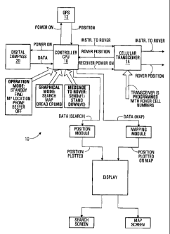
Figures 1 and 2 show general block diagrams for the controller and the rover
unit
modules and their interrelationship. The controller unit 10 has a GPS receiver
module
12, a cellular transceiver module 14 a display module 16 and control
electronics
module including a specially programmed CPU 18 and a digital compass 20. The
display 16 is preferably an interactive display such that various command
options can
be displayed and activated by touching the display screen. Software modules
include
the Operation Mode Module 22, the Graphical Mode Module 24, and the Message To
Rover Module 26. Outputs of the CPU 18 include the Position Module 28 which
operates the Search Screen Module 30 and the Mapping Module 32 which operates
the Map Screen Module 34.
The rover unit 36 has a GPS receiver 38, a cellular transceiver 40, and a
control
electronics module including a specially programmed CPU 42. Use of the
apparatus
and method is best understood with reference to the flow diagrams of Figs. 3-
11 as
well as the screen diagrams of Figs. 12-15.
Referring to Fig. 3, the controller unit is activated by a power-on step
indicated as
start 50. This causes the display 52 to open. As shown on Fig. 12, this
display, called
the home screen 54 has buttons for PHONE 56, FIND 58, EXIT 60, AND HOME 62
(which should be muted on the home screen 12). The user selects one of these
as at
step 64 on Fig. 3. PHONE selection allows use as at 68 as a conventional voice
cell
phone between the controller unit and a selected rover unit or as a general
use cellular
phone. EXIT selection turns off the controller unit as at 70. FIND selection
begins
the find procedure as at 72.
CA 02411138 2002-11-05
Fig. 4 shows the procedure if the PHONE button 56 (Fig. 12) was touched. This
opens the PHONE screen 74, Fig. 13, which has a scrollable list of
preprogrammed
numbers 76, an Up/DOWN scrolling button 78, a memory button 80, for adding or
deleting numbers, a MANUAL button 82 for going to the screen of Fig. 14 for
normal
telephone use, and a home button 84 to return to the home screen, Fig. 12. If
the
manual button 82 is touched, the screen 90 of Fig. 14 appears. It has a touch
pad 92, a
RECALL button 94, a CLEAR button 96., a SEND button 98, END button 100 and
HOME button 92. The screens of Figs 13 and 14 are for programming numbers
(Fig.
13) and using the controller unit as a voice cellular telephone (Fig. 14). The
use of
the buttons on Fig. 14 are conventional to cellular telephones.
At Figs. 3 and 12, if the user selects FIND, the find procedure of the
invention is
begun. A find screen 110 as shown at Fig. 15, appears on the display. This
screen has
a scrollable NAME window 112, which may be scrolled vertically to select a
rover or
horizontally as shown at 114 to display preprogrammed alarm criteria for each
rover
such as ZONE STATUS and ZONE RADIUS.
The GO button 116 activates the FIND DETAIL screen of Fig. 16. The ACTIVATE
ZONE button 118 allows programming and activating a zone radius. The zone
radius
will be displayed at ZONE RADIUS and communicated and stored in the rover
unit,
which is programmed to automatically call the controller unit and sound and/or
display an alarm if the zone radius is passed. ZONE STATUS shows whether the
rover is inside or outside the displayed ZONE RADIUS. The MEMORY button 120
stores a zone radius selection. The HOME button 122, returns the display to
the
HOME screen, Fig. 12. Touching the MEMORY button 120 brings up a screen (not
shown) to enable programming the functions of the FIND screen 110. This
procedure
is shown in the flow diagram of Fig. 6, FIND MEMORY.
With the FIND screen 110, displayed, the procedure shown in Fig. 7 is
implemented.
The scrollable NAME window 112 has a list of names and phone numbers that have
been pre-programmed. The user now selects HOME, MEMORY, or GO, 124. If the
CA 02411138 2002-11-05
-1 0-
MEMORY button 120 is touched, the FIND MEMORY procedure begins (Fig. 6)
which allows programming or deleting on the NAME window 112.
If the GO button 116 has been touched, the FIND DETAIL procedure of Fig. 8 is
begun and the FIND DETAIL screen 130, Fig. 16, is displayed. As shown in Fig.
8,
the FIND DETAIL procedure starts at 132 from the prior touching of the GO
button
116 of the FIND screen of Fig. 15 to set up the FIND DETAIL screen of Fig. 16.
The FIND DETAIL screen 130 has an identification window 132, a location and
data
window 134, a geographical coordinates window 136, a status window 138, and
buttons, HOME, 140, CENTER, 142, BREAD CRUMB, 144, STORE, 146, STOP
148 and MAP, 150.
Within the geographical coordinates screen 136, a reserve 152 shows a bearing
arrow
154 which operates via the CENTER button 142 for spatial relative positioning
of the
rover to the controller, in which the arrow shows the bearing of the rover
unit relative
to the controller unit. This is accomplished using the electronic compass
module (Fig.
1).
Touching the HOME button 140, returns to screen Fig. 12. Touching the CENTER
button 142 activates display of the spatial relative position bearing arrow
154, using
the electronic compass and the GPS positions of the controller and the rover.
The BREAD CRUMB button 144 is used with the MAP button 150 which will
activate the MAP screen Fig. 17 and will show the positions of the controller
and the
rover on a map, and with the BREAD CRUMB feature activated, will show a number
of prior GPS positions of the rover and will continue to display sequential
periodic
positions of the rover.
Although particular embodiments of the invention have been described and
illustrated
herein, it is recognized that modifications and variations may readily occur
to those
CA 02411138 2002-11-05
-11-
skilled in the art, and consequently it is intended that the claims be
interpreted to
cover such modifications and equivalents.