Note: Descriptions are shown in the official language in which they were submitted.
CA 02421941 2003-03-07
WO 02/21158 PCT/US01/28325
SYSTEM AND METHOD FOR ATTACHING DRILLING INFORMATION TO THREE-
DIMENSIONAL VISUALIZATIONS OF EARTH MODELS
Field of the Invention
The present invention generally relates to computer-based display of oil and
gas exploration and
production data. More particularly, the present invention relates to coupling
drilling operational events and
knowledge with an earth model in three-dimensional computer displays.
Description of the Related Art
During the last 20 years, the Exploration and Production (E&P) business has
been very successful in
reducing the costs of fmding and producing oil and gas reserves. However, it
faces challenges to profitability in
years to come. With the E&P industry competing for the same investment dollars
as other industries, it is essential
that operating conipanies continue to maxinzize the rate of return to their
shareholders.
E&P companies are now putting more focus on collaborative asset teamwork to
better evaluate the
economic viability and risk involved in developing prospective oil and gas
fields. To facilitate such collaboration,
E&P companies are adopting shared, integrated, IT technology to enable multi-
disciplinary teams to engage in
improved workflow processes across all phases of the oil field life cycle.
Traditionally, Geoscientists have had the benefit of powerful integrated
visualization tools. Such
applications are characterized by excellent integration and interoperability,
allowing workflow practices to be
optimized. This permits geologists and geophysicists to model and comprehend
the nature of the subsurface
environment when evaluating prospects and planning development projects.
Drilling engineers tasked with wellbore construction typically do not utilize
these integrated applications.
The earth model resulting from the explorationists' use of their tools is
rarely referenced directly by the drilling
engineer. The chasm between the explorationist and driller hinders optimum
wellbore construction planning and
execution, but presents a significant opportunity for operational improvement.
Summary of the Invention
One embodiment of the present invention comprises a system and method for
coupling drilling operational
knowledge with an earth model in three-dimensional computer displays. The
method may operate in a computer
system comprising a processor and a memory medium. The memory medium may store
a software program
according to one embodiment of the present invention. The processor may
execute the software program to 1)
display a three-dimensional representation of an earth model of one or more
wells; and 2) display one or more
knowledge attachment symbols on the three-dimensional representation, wherein
each knowledge attachment
symbol is configured to display -drilling operations data associated with the
knowledge attachment symbol in
response to user input.
As previously stated, the chasm between the explorationist and driller
presents a significant opportunity
for operational iinprovement. Coupling drilling operational events and
knowledge (contained within Drilling
Information Management Systems (DIMS)) with the earth model is a significant
operational improvement that may
be made to lessen the chasm. With the advent of more powerful personal
computers and laptops, drilling engineers
CA 02421941 2003-03-07
WO 02/21158 PCT/US01/28325
may now access similar visualization tools geoscientists have traditionally
used on computer systems such as UNIX
workstations.
Using three-dimensional visualization of the earth model as a foundation, a
new Information Technology
(IT) development strategy focuses on perceiving "Drilling Learning" by an
intuitive method. Symbols, known as
"Knowledge Attachments" may be attached to wellbore trajectories displayed in
a three-dimensional environment,
with each symbol indicating a specific event, such as one related to drilling
operations or problems. This method
may prove particularly useful to represent this disparate data together in one
user interface, and in such a manner
that the interdependencies between the earth model and drilling operations
data are evident and correlated.
Brief Description of the Drawings
A better understanding of the present invention can be obtained when the
following detailed description of
the preferred embodiment is considered in conjunction with the following
drawings, in which:
Figure 1 illustrates a network system according to one embodiment;
Figure 2 is a screenshot of an earth niodel with wellbore trajectory and
associated Knowledge Attachments
according to one embodiment;
Figure 3 is a screenshot of a Knowledge Attachment display according to one
embodinient;
Figure 4 is a screenshot of another example of an earth model with wellbore
trajectory and associated
Knowledge Attachments according to one embodiment; and
Figure 5 is a screenshot of another example of a Knowledge Attachment display
according to one
embodiment.
Detailed Description of the Embodiments
The following documents are hereby incorporated by reference in their entirety
as though fully and
completely set forth herein:
Foley, J. and Ribarsky, B.: "Next Generation data visualization Tools",
Georgia Institute of Technology,
USA. (1994).
Dent, H.: "The Roaring 2000s", Simon & Schuster, New York (1998).
Yu, A.: "Creating the Digital Future", The Free Press, New York (1998).
Figure 1: Network System
Figure 1 illustrates a simplified and exemplary network system according to
one embodiment of the
present invention. The embodiment illustrated in Figure 1 includes one server
102 and one Knowledge Attachment
computer system 106, which may be connected to a network 104 such as the
Internet. However, it is noted that the
present invention may be utilized with respect to any number of servers 102
and systems 106.
As shown, the server 102 may be connected to a network 104, in one embodiment
the Internet 104. The
Internet 104 is currently the primary mechanism for information interchange.
However, the present invention may
be used with any of various types of wide-area networks, or networks of
networks, such as the Internet, which
connects computers and networks of computers together, thereby providing the
connectivity for enabling
2
CA 02421941 2003-03-07
WO 02/21158 PCT/US01/28325
communication and information exchange. Thus, the network 104 may be any of
various types of networks,
including local and/or wide area networks, and including wired and wireless
networks, or combinations thereof.
Knowledge Attachment system 106 may also be connected to the Internet 104. The
Knowledge
Attachment system 106 may be of various kinds. of systems such as a desktop
computer system, a notebook
computer system, a workstation, etc. The system 106 may execute web browser,
network-based database access,
and other network software for allowing a user of the system 106 to browse
and/or search the Internet 104, as well
as enabling transactions over the Internet 104 such as database queries. The
network connection software may use
3-D visualization and other software executing within the Knowledge Attachment
system 106 to access various
E&P data such as earth model, wellbore trajectory, and Knowledge Attachment
data stored in databases on one or
more servers 102. This information may be used to provide a 3D visualization
of the earth model and to create and
display Knowledge Attachments for various features of the earth model.
When the user of the system 106 desires to access detailed information for a
Knowledge Attachment, the
network software may accesses one or more servers 102 to retrieve the detailed
information. For example, the
system 106 may access a web page of the server 102.
The server 102 and/or system 106 may include various standard components such
as one or more
processors or central processing units, one or more memory media, and other
standard componerits, e.g., a display
device, input devices, a power supply, etc. The server 102 and/or system 106
may also be implemented as two or
more different computer systems.
A server may be defmed as a computer or computer program that, when executed,
provides services to
other computer programs executing in the same or other computer systems. The
computer system on which a
server program is executing may also be referred to as a server, though it may
contain a number of server and client
programs. In the client/server model, a server is a program that awaits and
fulfills requests from client programs in
the same or other computer systems.
The Knowledge Attachment system 106 preferably includes a memory medium on
which computer
programs according to the present invention are stored. The term "memory
medium" is intended to include various
types of memory or storage, including an installation medium, e.g., a CD-ROM,
or floppy disks, a computer system
memory or random access memory, e.g., a random access memory (RAM), such as
DRAM, SRAM, EDO RAM,
Rambus RAM, etc., or a non-volatile memory such as a magnetic media, e.g., a
hard drive, or optical storage. The
memory medium may comprise other types of memory as well, or combinations
thereof. In addition, the memory
medium may be located in a first computer in which the programs are executed,
or may be located in a second
different computer that connects to the first computer over a network. In the
latter instance, the second computer
provides the program instructions to the first computer for execution. In
addition, the server 102 and/or system 106
may take various forms, including a computer system, mainframe computer
system, workstation, or other device.
In general, the term "computer system" or "server" can be broadly defmed to
encompass any device having a
processor that executes instructions from a memory medium.
The memory medium preferably stores software for enabling the displaying of
symbols, referred to as
Knowledge Attachments, attached to a wellbore trajectory displayed in a three-
dimensional environment, with each
symbol indicating a specific event, according to the methods or flowcharts
described below. The software program
may be implemented in any of various ways, including procedure-based
techniques, component-based techniques,
3
CA 02421941 2003-03-07
WO 02/21158 PCT/US01/28325
and/or object-oriented techniques, among others. For example, the software
program may be implemented using
ActiveX controls, C++ objects, Java objects, Microsoft Foundation Classes
(MFC), or other technologies or
methodologies, as desired. A CPU, such as the host CPU, executing code and
data from a memory medium
comprises a means for coupling drilling operational knowledge with an earth
model in three-dimensional computer
displays according to the rrlethods, flowcharts or screen shots described
below.
In another embodiment, Knowledge Attachment system 106 may be a standalone
system, not connected to
a network 104 or to a server 102. In this embodiment, the Knowledge Attachment
System 106 may include all
required databases to generate the 3D visualization with Knowledge
Attachments. In yet another embodiment,
server 102 and system 106 may be directly connected instead of connected
through a network 104.
Various embodiments further include receiving or storing instructions and/or
data implemented in
accordance with the foregoing description upon a carrier medium. Suitable
carrier media include memory media or
storage media such as magnetic or optical media, e.g., disk or CD-ROM, as well
as signals such as electrical,
electromagnetic, or digital signals, conveyed via a communication medium such
as networks and/or a wireless link.
Perceiving Drilling Learning through Visualization
For the purposes of this application, a definition of visualization may
include the concept of binding (or
mapping) of data to a representation that can be perceived. At a high level,
the data being bound is that of an earth
model and Drilling Information Management Systems (DIMS) operational data. An
earth model may be defmed as
a spatial model of the earth surface and subsurface, containing a network of
earth model objects, such as rock and
fluid bodies. In one embodiment, an earth model may be generated in a project
data environment, e.g. the integrated
OpenWorks project data environment. Integration of the data from these
different sources in the same
visualizations may enable visual analysis. This system may prove particularly
useful in representing this disparate
data at once, in such a manner that the interdependencies can be made clear.
The interactive data binding coupled
with the 3-dimensional (3D) display will greatly enbance the ability to
analyze these complex data sets and speed
up the process of extracting information.
For visual analysis, it is desirable that the tools for accessing and
filtering the data be tightly integrated
with the visualization environment. When working in a team environment, visual
analysis may provide, but is not
limited to, the following benefits:
speeds communication
conveys subtlety
builds trust
promotes creativity
speeds and enhances decision making
Embodiments of the invention may provide integrated well planning, where
powerful, three-dimensional
visualization tools allow the geologists and geophysicists to collaborate more
closely with the drilling engineers at
the very early stages of prospect assessment and well design. Embodiments of
the invention may also reduce the
overall interpretation and planning cycle time.
4
CA 02421941 2009-02-06
Further advances in information technology (IT) are promoting close asset team
collaboration to extend from the well planning process in the office to the
well construction
operations in the field. Embodiments of the invention may merge Earth Model
information,
offset well drilling histories, and data gathered in real-time from mud-
logging sensors and
Measurement While Drilling (MWD) and Logging While Drilling (LWD) tools into
one
integrated work environment. Embodiments of the invention may include a
shared, three-
dimensional view of the subsurface Earth Model, both at the well site and in
the office,
against which both planned and actual drilling information is displayed.
Embodiments of the
invention may include the capability for the geologists and geophysicists to
compare the
planned Earth Model with actual down hole log data and to transmit a
reinterpreted model
back to the field when required. For the chilling engineers in the office and
the drilling
supervisors at the well site, embodiments of the invention may provide a
continuous
visualization of the sub-surface environment that allows closer monitoring of
actual drilling
progress and better contingency planning for expected problem areas.
With such a wealth of well planning and well construction information now
available
to the asset team in one integrated environment, embodiments of the invention
may provide
methods to compare the information from the various, disparate data sources
and to determine
the interdependencies between the complex data sets. For example, this may be
beneficial
when assessing the viability of new well designs in an existing field
development.
Embodiments of the invention may provide additional tools that allow the asset
team to
rapidly deduce "lessons learnt" from previous wells, and to incorporate this
learning into
future well design and operations.
Embodiments of the invention may enable the access of DIMS information and
facilitate the capture of "drilling learning" through visualization of the
earth model.
Embodiments may include data management for the earth model and drilling
information.
Examples of such database management systems are OpenWorks for the earth model
and
DIMS for the drilling information. Some embodiments of a system for perceiving
drilling
learning through visualization may also include a 3D visualizer that may
integrate the two
data sources utilizing Knowledge Attachments. In one embodiment, a Windows NTO-
based
3D visualizer may be used. In some embodiments, the 3D visualizer may be
integrated with a
project data environment, e.g. the integrated OpenWorks project data
environment, providing
3D views of the earth model. In some embodiments, the viewer may also be an
part of a 3D
system, e.g. a real-time drilling and reservoir solution such as the
RESolution 3DTM system,
which may provide a real-time link between a project data environment, e.g.
the integrated
OpenWorks pro eco data environment, and a rig information system, e.g. Sperry-
Sun's InSite
system.
Using earth model visualization as a foundation, embodiments of the invention
may
allow the capturing "drilling learning" by an intuitive method. In one
embodiment, symbols,
known as "Knowledge Attachments", may be attached to each wellbore trajectory
displayed
in the three-dimensional environment to indicate a specific event, such as one
related to
drilling operations. Knowledge Attachments may be displayed on a wellbore
trajectory in the
3-dimensional earth model that is bound to drilling operations data. The
drilling operations
data is accessed and filtered using database queries. A wellbore may be
defined as a unique,
oriented hole from the intended bottom of a drilled interval to the surface of
the Earth. If more
than one path exists from a wellbore bottom point to a surface point, then
more than one
wellbore exists. The wellbore provides a conduit for operations within a well.
In one embodiment, the visual appearance of the Knowledge Attachment may
depend
on the type or category of underlying information, e.g. DIMS information, to
which it is
bound. For example, a red asterisk might be chosen as the display symbol to
indicate a stuck
pipe event at a certain measured depth. In some embodiments,
5
CA 02421941 2003-03-07
WO 02/21158 PCT/US01/28325
each Knowledge Attachment may include multiple levels of information. In one
embodiment, each Knowledge
Attachment may include two levels of information: summary and detailed. In
this embod'unent, clicking on the
syxnbol may display the summary information. The summary view may be
represented much like a post-it note
when the symbol is clicked. The post-it type display may include an area for
displaying and/or entering free
formatted text. The well name and Knowledge Attachment depth may also be
displayed in the summary. Links to
any detailed content available may also be displayed in the summary view. The
detailed content may be in any of
several forms, including, but not limited to: documents (files), web links
(URLs), or a direct link to database
information such as related drilling database information. In one embodiment,
the appearance and underlying data
source of the Knowledge Attachment may be configurable on a site and user
basis.
A benefit of this approach to visualizing data may be the speed of
accessibility to the more valuable
information captured on previous wells. This may allow drilling engineers and
the other asset team members to
better assess technical risk from the outset of prospect development and well
planning, and to manage the risk more
effectively.
Defmition of standard symbols.
A standard set of Knowledge Attachment display symbols may be provided so that
information can be
visually correlated with certainty of what it represents. The visual
appearance of each Knowledge Attachment is
dependent on the type (or category) of information to which it is bound. In
one embodiment, the appearance and
underlying data source of the Knowledge Attachment may be configurable on a
site basis. For example, a red
asterisk may represent a lost circulation event, while a yellow circle may
represent an occurrence of stuck pipe. In
one embodiment, a standard library of symbols may be provided. In one
embodiment, user defmed symbols may
be created, e.g. for unique circumstances.
Information content of Knowledge Attachments.
Figures 3 and 5 illusttate embodiments of Knowledge Attachment displays or
dialogs that include two
levels of information, summary and detailed. The summary view is displayed
when a symbol on a wellbore
trajectory such as those illustrated in Figures 2 and 4 is clicked. In Figure
3, the Knowledge Attachment display
300 may include a free-form area 304 for the user to enter pertinent comments.
The well name and Knowledge
Attachment depth may be displayed in the summary 302
Links to detailed content may also be displayed in the Detailed Information
306. The detailed content may
be a collection of documents (files); links to web pages, morning reports, and
database queries. For example,
assume the Knowledge Attachment 300 represents a well control incident.
Examples of information provided
detailed content may include, but is not limited to: a spreadsheet with the
completed kill sheet, a link to a well
control best practices page on the company intranet, and a copy of the morning
report. When an item in the
detailed content list 306 is selected, an appropriate application may be
launched to view the information.
Creation of Knowledge Attachments
Once a standard set of Knowledge Attachment types aiid associated symbols are
defmed, the appropriate
data is bound to them. Knowledge Attachments may be created in one of two
ways: manually or automatically.
6
CA 02421941 2003-03-07
WO 02/21158 PCT/US01/28325
When creating a Knowledge Attachment manually, a well, depth, and attachment
type may be selected.
Next, a user may provide the text for the summary, and then may create links
to appropriate detailed content.
Manually created Knowledge Attachments may be used in the well planning
process to document operational issues
or directives. They also may serve as a good communications tool for handing
off information during a "hitch
change".
Automatically creating Knowledge Attachments facilitates drilling learning.
The appropriate drilling
operations data may be associated with the symbol using database queries. A
database query is constructed and
associated with a Knowledge Attachment symbol. The database query is then
executed against the database. The
Knowledge Attachment appears in the 3D viewer in the context of the earth
model. By using generic defniitions
(templates), a standard library of Knowledge Attachment defmitions may be
maintained which may be independent
of the well or field. A fully defmed Knowledge Attachment template may include
a symbol type and the associated
database query. This library may facilitate the integration and interrogation
of drilling data in the earth model by
making access to the data easy and intuitive. Examples of such templates
include, but are not limited to:
Stuck pipe Lost Circulation
Bit Change Reaming
Kick High Torque
Hard Stringers Packing Off
Tight Hole Drilling Comments
Trouble Time
The detailed information behind the template may be bound to the Knowledge
Attachment when the well(s)
or field is rendered in the visualization environment. Embodiments of the
invention enable identifying this
information and then correlating it among large numbers of wells, and
facilitates the creation of better well designs
and improved operational efficiency by learning from prior experiences.
Examples of Knowledge Attachments
Figures 2 and 4 illustrate examples of 3D views of wellbore trajectories with
symbols representing
Knowledge Attachments according to embodiments of the invention. Knowledge
Attachments may be used to
improve many aspects of the wellbore construction process: planning,
operations, and post well analysis.
An example is a field where several wells have been drilled and new wells are
being planned. Early on in
the well planning process, the system may be used to learn about issues
encountered with existing wells in the area.
New or experienced drilling engineers can easily access the historical data
and view it within the earth model. The
existing wells are shown in Figure 2. In this example, a Trouble Time template
is chosen, and the drilling data
management system is accessed. The 3-dimensional view is automatically
populated with Knowledge Attachments
for all occurrences of Trouble Time for wells in the field, based on morning
report information.
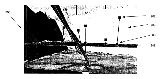
In Figure 2, these Knowledge Attachments are represented by small squares and
small circles used to
represent drilling events on the 3D view 200. In this example, the squares 202
along the fault 204 identify High
Torque areas, and the circles 206 along the horizontal horizon 208 identify
Lost Circulation. By clicking on any of
7
CA 02421941 2003-03-07
WO 02/21158 PCT/US01/28325
these Knowledge Attachments, the detailed and summary information for the
selected Knowledge Attachment may
be displayed as illustrated in Figure 3, allowing further analysis. Thus, the
planned well can be designed to
minimize these known issues. In complex geology with subtle problems, these
correlations may not be perceived
without a system such as the described Knowledge Attachment system. If
engineers have to filter tlirough printed
reports to access this information, it is probable that problems encountered
and lessons learned from prior wells
would be overlooked. The Knowledge Attachment system may be particularly
useful to drilling engineers not
familiar with an area.
Once the well is planned and drilling commences, the Knowledge Attachment
system may continue to be of
value. Offset well information can continue to be accessed and the plan
refmed, before trouble is encountered.
Knowledge Attachments may be manually created for purposes of handing off
information during a hitch change
and documenting operational directives to be implemented in various sections
of the well.
During the post-well analysis, the Knowledge Attachment system may be used to
gather lessons learned and
help improve the operational efficiency of future wells. The Knowledge
Attachment system may also be a valuable
training aid for new engineers.
System Components
Data Analyzer
A series of canned queries may be provided for processing that can be applied
to any series of wellpaths in
a project area. The queries may later be customized for customer / operations
specific data. The Query
results may be attributable to a well and downhole depth, and DIMS activity
code (for example lost time). These
queries may be stored for reuse; for example, the queries may be stored in
DIMS. The extract may produce data in
a column format to be accessed by the 3D visualizer. The queries may be
processed "behind the scenes", and the
results returned to the 3D Visualizer. A database query may extract
information including, but not limited to:
= Measured Depth (of TD or bit depth at time of event)
= Rig Datum Reference.
= Well name - has to have linkage table to OpenWorks names.
= Activity Code.
= Activity comments.
= Date/Time.
= Internal DIMS Keys for indexing (e.g. E_KEY, R KEY, I KEY)
3D Visualizer
Some embodiments of a system for perceiving drilling learning through
visualization may also include a
3D visualizer that may integrate data sources utilizing Knowledge Attachments.
In one embodiment, a Windows
NT-based 3D visualizer may be used. In one embodiment, the RESolution3D Viewer
may be used as the 3D
visualizer. Other embodiments may utilize a Java programming language-based 3D
visualizer.
8
CA 02421941 2003-03-07
WO 02/21158 PCT/US01/28325
Functionality
The Knowledge Attachment system may include, but is not limited to, the
following functionality:
1. One or more user interface items such as button or menu/items to "Show
Knowledge Attachments" or
"Create Knowledge Attachment".
In general, Knowledge Attachments may be created in one of two ways, manually
or automatically. When
creating a Knowledge Attachment manually, the user may select a well, depth,
and display symbol. Next, the user
may provide the text for the summary and then may create the links to the
appropriate detailed content. The links
may take many forms including, but not limited to: Microsoft Office Documents,
DIMS Reports, DIMS Data
Analyzer Queries, iDIMS, or any Web pages.
The automatic creation of Knowledge Attachments may center on DIMS and a data
analyzer. In one
embodiment, the user may create a Data Analyzer Query for a set of wells and
select an associated display symbol.
The Query may be run and the Knowledge Attachments may be displayed on the
well trajectories. For example,
the user may create a Data Analyzer Query for Unplanned Time &"Stuck Pipe". A
red asterisk may be chosen as
the display symbol. After running the Query, all occurrences of stuck pipe are
easily identifiable for the wells
being visualized. The post-it may display the depth and well name and contain
a link to the detailed information in
DIMS. The user can then add more links if desired. Desirable links may
include, but are not limited to: wireline
logs, borehole images, and core photos. In one embodiment, if a file extension
is registered with Windows and that
file type is added as a link, then the application will start upon double
clicking the link. For example, a core photo
in JPEG format may be added as a link; when the user double clicks the link,
the web browser (or other registered
JPEG viewer) may be launched and the core photo is displayed.
2. The Dialog reads from a knowledge list and presents a list of "Drilling
Attributes", for example pre-
canned Data Analyzer queries stored in DIMS. Examples may include, but are not
liniited to:
= Lost Circulation - remedial action / Pumping LCM etc.
= Stuck Pipe / Jarring / Fishing / Plug Back / Ream Tight Spots / Hang-up
= Well Control - Take Kick / Control Kick / Abnormal Gas
= Bit Problems - Premature failure. -
= Downhole Equipment Failure
An attribute type may be associated with a symbol. A system configuration may
define standard categories
and symbols for Knowledge Attachments. Configuration may be done at the
corporate level (analogous to DIMS).
Standards may be defmed and enforced so that symbols are not misinterpreted
3. Select an Attribute Type and the attribute symbol may be displayed on the
3D visualization associated
with the well(s) of interest. As an example, "Lost Circulation" attribute 212
is shown on three wells in the 3D
visualization 210 of Figure 4. Symbols are displayed on the wellbore
trajectory in 3D space bound to the DIMS
data. The bound symbols are referred to as "Knowledge Attachments".
One embodiment may support the culling of symbols based on a zoom factor. In
one embodiment,
sections of the wellbore may be symbolized. One embodiment may support symbols
for multiple symbols.
9
CA 02421941 2009-02-06
4. A user clicks on one of the symbols shown in Figure 4 and the Knowledge
Attachment
dialog 310 as illustrated in Figure 5 appears for that event for that well.
Header Information
302 may display the Well Name, Depth of Interest and Date/Time. The comments
304 are the
extract from the DIMS report. The comments 304 may contain information
including, but not
limited to:
= Shift hand over
= Warning information or near misses
= Auto generated information from DIMS queries
In one embodiment, to relieve the user of the task of performing multiple data
entry in
comments 302, comments 302 may be auto populated as much as possible.
Detailed information 306 may include links to detailed/information for the
Knowledge
Attachment 310. Clicking on a link may access the detailed content for the
link. The detailed
content may include, but is not limited to: documents (files), web links
(URLs), and DIMS
data. The appropriate application may be started to view the detailed
information (e.g
Microsoft Word, Microsoft Internet Explorer etc.)
Knowledge Attachment 310 illustrated in Figure 5 may include the following
options.
DIMS Morning report option may send an event to iDIMS to display the relevant
morning
report 308. Display the Best Practices Document option may automatically
insert a link to a
stuck pipe best practices web page 312 whenever a stuck pipe Knowledge
Attachment is
created. The same may occur for other Knowledge Attachment types. In some
embodiments,
Knowledge Attachments may be interdependent or threaded (i.e. linked Knowledge
Attachments).
Embodiments of the invention may handle the conversion among the appropriate
datum offsets used in different components of the Knowledge Attachment system.
Trouble Time Codes are often different between different operating companies.
In
some embodiments, operations codes may be identified for downhole events that
can be
attributed to geological features (e.g. lost circulation, stuck pipe).
Some embodiments of the invention may support the capture of depth
information.
This may be achieved by flagging the appropriate depth fields as mandatory.
Some embodiments may support relative depths. For example, flagging an event
at a
formation top plus a depth offset.
A number of activities may be associated with a single downhole event, for
instance a
jarring / pump slugs / fishing / plug back & sidetrack may take several days.
The query, or
post query tool may identify the original source of the problem. Morning
report comments
often deal with the `what' happened rather than the `why'. Some post-event
activities may
lead to better diagnosis of downhole problems. Fuzzy queries may be supported
in some
embodiments and may prove useful by using searches in the comment field for
particular
keywords like `stuck, tight-spot, kick, gas, jarring, LCM, spot pill, drill
blind'.
On stuck pipe issues, some embodiments may allow diagnosing the cause of the
sticking, be it Differential, Pack-off/Bridging or Geometry related. In
addition, the stuck point
may not be the bit depth, and the stuck depth may be determined from the
reports i.e. free
point techniques. For instance, shale expansion causes problems some time
after the section
has been drilled. Lost circulation or well control locations may also not be
the bit depth. In
one embodiment, the bit depth may be used, but the value can be changed by the
user.
Another embodiment may support two depth fields, such as Bit Depth and Stuck
Point.
CA 02421941 2003-03-07
WO 02/21158 PCT/US01/28325
In some embodiments of a Knowledge Attachment system, if a Query that returns
a depth can be
structured, it can be assigned to a Knowledge Attachment. In one embodiment,
the Knowledge Attachments may
be attached to events, e.g. DIMS events, and thus may provide the ability to
view the moming report.
Some embodiments of a Knowledge Attaclunent system may not have their own
database but may pull
data from other sources, e.g. DIMS and OpenWorks. When Knowledge Attachments
are created Knowledge
Attachment system, they may be stored external to the Knowledge Attachment
system, for example, in a database
such as OpenWorks or DIMS.
In one embodiment, the user may create queries for re-use. The user will then
be able to select from a list
including these reusable queries
On embodiment may support the display only the data within a certain range of
a given fault plane, for
example, 50 meters.
One embodiment may support a data file such as a Virtual Reality Markup
Language) (VRML) file that is
fnlly portable and contains all the relevant data and links.
Some embodiments may be used to visualize BHA, bit type, casing seat and/or
ROP information. This
significantly widens the range of uses a drilling engineer has for such a
tool. In one embodiment, ROP may be
viewed as a Log Curve in the viewer. In one embodiment, a BHA change or Bit
Change event can be represented
as Knowledge Attachment.
Conclusion
A Knowledge Attaclunent system proves particularly useful to represent
disparate data at once, in such a
manner that the interdependencies between the earth model and drilling
operational data are evident and correlated.
Operational issues and lessons learned from prior wells are easily accessed
and perceived in the context of the
earth model. By understanding this information at the beginning of the well
planning process, operational
efficiencies can be improved.
Although the system and method of the present invention have been described in
connection with several
embodiments, the invention is not intended to be limited to the specific forms
set forth herein, but on the contrary,
it is intended to cover such alternatives, modifications, and equivalents as
can be reasonably included within the
spirit and scope of the invention as defined by the appended claims.
11