Note: Descriptions are shown in the official language in which they were submitted.
CA 02424748 2003-04-02
METHOD FOR DISPLAYING THE OPERATING CONDITIONS OF AN INSTALLATION
The invention concerns a method of displaying the operating
behaviour of installations such as for example wind power installations,
water treatment installations, block heating and generating installations,
transformer stations, and so forth.
It is known that the operating behaviour of an installation can be
continuously detected and the detected data can also be made available to
the operator of the installation. If for example the operator of an
installation has a suitable telecommunication device {for example a
modem), he can obtain information about ail relevant data of his
installation, for example whether it is in operation, the output power with
which it is operating at the present time or whether there is a fault, and if
so, what the reason for the fault is, and so forth. It will be appreciated
that
environmental data at the installation but also other measured data of the
installation can also be called up.
Those environmental data in the case of wind power installations can
be for example the direction of the wind, the speed of the wind,
temperature, and so forth, while in the case of water treatment installations
these can be for example levels, temperatures, and so forth.
The above-described solution however is always tailor-made to the
customer of the manufacturer, that is to say generally the operator of the
installation, and third parties have no possibility of inspecting the data,
but
this situation involves operating data which are to be kept secret and which
should or may not be made available to just anyone.
It is nonetheless desirable also to make certain items of operating
data from a plurality of installations, for example the installations of a
manufacturer, available to third parties, so that they can have an overview
of the reliability of the installations, in which respect nonetheless the wish
on the part of the operator of the installation for confidentiality is still
satisfied.
CA 02424748 2003-04-02
,
a,
Z
The object of the present invention is to provide a technical solution
in this respect, which in particular is attractive and which affords a fast
possible way of affording an overview relating to sites and/or the operating
behaviour of installations.
The object of the invention is achieved with the method set forth in
claim 1. Advantageous developments are described in the appendant
claims.
The invention is based on the following considerations:
The operating data of installations, for example the installations from
a given manufacturer, are logged or acquired. The acquired operating data
are classified, for example as to whether the installation is at all ready for
operation (whether, in the case of a wind power installation, for example, it
is connected to the network) or not. If the installation is not ready for
operation, this can be still further classified, for example in such a way
that
the reason for the non-serviceability/the installation fault is also
specified.
Non-serviceability can be caused for example by a breakdown in operation
a technical fault (for example a fire in the generator of a wind power
installation) - or however also due to ordinary maintenance procedures
which have to be carried out from time to time in relation to installations
and during which the installations frequently have to be switched off.
If the installation is serviceable, it is possible to specify under some
circumstances whether it is or not operating under nominal operating
conditions.
The data classified in that way can be assembled together and then
optionally associated with the respective geographical position of the
respective installation. It will be appreciated that alternatively it is also
possible to associate the data with the respective installation itself on the
basis of a unique distinguishing feature, such as for example a serial
number. In that respect geographical data describing the site of the
installation can equally be associated with the installation. Finally a symbol
is specified in an overview such as for example a geographical map (for
example a map of Germany) for each installation or a group of installations,
in which case the nature of the installation and the operating status of the
CA 02424748 2003-04-02
3
respective installation or a group of installations can be derived from the
symbol. In this respect the symbol is automatically derived from the data
associated with the installation, in accordance with a predeterminable
algorithm.
S Thus for example a symbol such as a green circle can signify that the
installation is a wind power installation which is (serviceable) in operation
while a symbol such as a red circle indicates that the installation is out of
operation. The symbol of a red-green circle (a red semicircle and a green
semicircle are put together to form a circle) can indicate that the
installation is admittedly basically serviceable but is switched off by virtue
of maintenance operations.
The overview provided in that way can identify various kinds of
installations and is constantly updated, stored in the form of an electronic
file and made available in an information network, for example an Internet
network, and made available for being called up by way of an Internet
domain address, for example by way of the address of the installation
manufacturer.
Now anyone who has Internet access can obtain a picture of the
entire 'fleet' of installations produced by the installation manufacturer,
within a given geographical area, for example within Germany. In that case
he not only learns where such installations are disposed but also what the
respective operating condition thereof is, that is to say whether the
installation is in operation or whether it is not operating satisfactorily by
virtue of an operational disturbance.
It is also advantageous not only to associate still further data with an
operating site of an installation but also to already represent it on the map.
Such data can be for example the operating times of a given past period of
time, for example the past month, the last year and so forth, so that the
person viewing it also has a highly informative picture about the reliability
of an installation.
Thus, by virtue of the constantly updated acquisition of operational
data, it is possible by way of a network such as for example the Internet for
anyone to obtain online a continuously updated map which also shows the
CA 02424748 2003-04-02
t'
4
viewer the serviceability of a plurality of installations in a given
geographical area, and this is always on an up-to-date basis (or up-to-date
in the context of a day or a week).
The invention is described in greater detail by means of an
embodiment with reference to the drawings in which:
Figure 1 shows a structure in principle for producing a map,
Figure 2 shows an embodiment of a map, and
Figure 3 shows an alternative representation in relation to Figure 2.
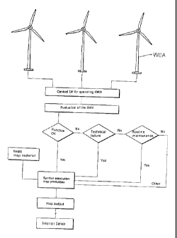
Figure 1 symbolically shows a number of N installations, wind power
installations (WEA) being considered in the example hereinafter. This is to
involve all or at least a given part of the installations of a manufacturer or
an operator, which are set up in a given geographical area and which are
maintained by the operators.
From the installations there is a direct or indirect data connection to
a central data processing station to which all operating data measured at
the installations are transmitted and processed there. The data are for
example the power output data, wind data and also temperature data of
given units and so forth.
After the data are acquired, the data are evaluated and classified in
respect of predetermined functions of the installations. Thus, the procedure
firstly involves ascertaining from the operating data whether the installation
is at all delivering power or is serviceable. That information is used as the
basis when producing or updating an electronic overview.
If the installation is found not to be serviceable, a check is made to
ascertain whether this is to be attributed to a technical failure. If that is
the
case, that information is also processed for producing or updating the
overview. If however the situation does not involve a technical failure
(technical failures are those failures which are to be attributed to the
breakdown of certain technical elements of the installation such as rotor,
generator, inverter, transformer and so forth), the procedure involves
checking whether the deficiencies in serviceability are to be attributed to
routine maintenance operations.
CA 02424748 2003-04-02
S
Such routine maintenance operations have to be carried out at
certain intervals in relation to installations in order to guarantee reliable
operation of the installations. When routine maintenance operations are
being carried out, that information is also suitably further processed when
producing the overview. If however no maintenance operations are also
being implemented, the failure of the installations can be attributed to
other reasons. Such a reason may also be that for example an installation
within a wind part is admittedly serviceable but the connection to the whole
of the wind park is faulty, because for example the entire connecting
network is out of order or the operator of the connecting network has
uncoupled the wind park from the connecting network, for technical
reasons.
The respective items of information are processed in a block for
symbol association for setting up an electronic overview. That block also
involves processing for example basic map material, for example a
geographical map of Germany, in electronic form.
As each installation is associated with a definite geographical
position, it is now possible to produce a map in which a symbol is
associated with each individual installation, wherein the shape and/or
colour and/or representation of the symbol (for example flashing or not
flashing) specify whether the installation is serviceable and if not, how the
reason for non-serviceability thereof is classified, whether therefore the
situation involves a technical failure or maintenance operations are being
conducted or there is some other reason.
After the map has been produced and updated it is stored and
outputted (Figure 2) and made available for example to the Internet server
of the manufacturer of the installations so that an interested party can
obtain information about the entire 'fleet' of installations of the
manufacturer/operator by clicking on predetermined symbols on the home
page of the manufacturer/operator.
It will be appreciated that it is also possible that, when blending in
the map and altering the symbols, the external shape of the symbols at the
same time also symbolises the nature and/or the type of the installation.
CA 02424748 2003-04-02
6
Thus for example the symbol of a rectangle can mean that this
involves wind power installations of a given type from the power class of
about 500 - 600 kW while a round circle denotes an installation of a given
type in the class of about 1.5 - 1.8 MW.
S By touching the symbol of an installation or a wind park with a
pointer such as for example a mouse pointer or by clicking or double
clicking on the symbol, it is possible to display further selected, openly
available items of information about the installation or the wind park.
In addition the symbols can involve a linking to the manufacturer
and/or operator of the installation or the wind park. That makes it possible
for third parties to implement a communication with the
manufacturer/operator and exchange information in a simple fashion, for ,
example by e-mail.
Further data can be made available for the operator of an installation
or a wind park so that the operator can call up all data relevant to him
about the network.
In order to prevent abuse of or unwanted or unauthorised viewing of
confidential data, certain data can be stored in a separate (logical) region
which is protected from unauthorised accesses by access control such as
authentication or the like.
As an alternative to the above-described map production procedure it
is also possible not to produce a geographical map - Figure 2 - but to
record all installations in an overall overview list - Figure 3 - so that then
those data appear without reference to geography in an overall overview
list or table, from which then the viewer can immediately see how many
installations of the manufacturer/operator are in operation and how many
thereof are in turn also serviceable (or also not serviceable).
Figure 2 shows by way of example a map of Germany (in symbolic
form) with the symbols recorded thereon for individual installations.
Therein the external shape of a symbol denotes a given type of an
installation, for example a square stands for type E-40 (from Enercon), an
installation from the power range of 500 - 600 kW, a circle stands for
example for type E-66 (from Enercon), an installation from the power range
~
CA 02424748 2003-04-02
7
of 1.5 - 1.8 MW, and a triangle stands for type E-30 - an installation from
the power range of 200 - 300 kW.
If a large number of installations are combined together in a wind
park that can also be identified by a suitable independent (wind park)
symbol.
The colouring of the symbols or their hatching or representation (for
example rapidly, slowly or not flashing) symbolise the serviceability of the
installation or, if that is not the case, the possible reason for the failure
or
outage. It is also possible in that way to indicate the deviation of
predetermined key data or comparative values in order to signal the
deviation.
Figure 3 shows an alternative overview representation which
however does not give the geographical reference of the installation. While
the individual position of the installation can also be approximately seen in
the map shown in Figure 2, that reference is not to be found in the
representation in Figure 3. It will be noted however that the person looking
at the overview illustrated in Figure 3 can see more quickly than from the
map in Figure 2, what the situation is in regard to serviceability of the
installations making up the 'fleet' of the manufacturer/operator who makes
the information available on the Internet.
The respective maps or overviews can be produced by virtue of
continuous operating data acquisition in up-to-date fashion, that is to say
with the up-to-dateness of a day or less but also with the up-to-dateness of
a week. The person looking at the map/overview can see therefrom, how
reliable (or how unreliable) the installations of a given
manufacturer/operator generally are and can form therefrom a judgment
about the quality of the installations.
Besides the functional or operating data of. the installations, it is also
possible to specify, in relation to each installation, the wind data and/or
the
operating data of the individual installations or the data relating to the
total
amounts of energy delivered by the installation. It is particularly desirable
to name not only the power availability - A - of the entire installation and
'fleet', but also the respectively produced amount - B - of electrical energy,
CA 02424748 2003-04-02
in relation to given periods of time, for example a day, a month, a year and
so forth.
In order to improve the clarity of the overview when dealing with a
large number of different kinds of installation, at least one kind of
installation and preferably each desired kind of installation can be cut out
of
the overview in order in that way to represent a smaller number of kinds of
installation in the overview.
In that way the person looking at the situation can limit himself to
the kind of installation which is relevant to him and in that way more
quickly gains an impression of the situation of precisely that kind of
installation. In that way it is possible to arrive at an overview for example
of wind power installations or an overview of wind power installations and
water treatment installations.
In addition, it is advantageously possible to implement a change in
representation, for example from a geographically oriented overview, as
shown in Figure 2, to an overview set up in tabular form, as shown in
Figure 3, and vice-versa, in order to acquire an overview having regard to
various criteria in respect of order, such as spatial arrangement (Figure 2),
or on the basis of statistical assessments, for example according to nature
and type of the installations (Figure 3).
In addition it is possible to facilitate contemporaneous representation
of a plurality of similar views, that is to say for example views comparing
the representation of a plurality of geographical regions side-by-side, in
which case the size of each individual representation can be adapted to the
needs of the person viewing same.
Alternatively various kinds of views such as tabular overviews and
geographically oriented representations can be represented in side-by-side
relationship.