Note: Descriptions are shown in the official language in which they were submitted.
CA 02429875 2003-05-27
APPLICATION FOR PATENT
Inventor: Anat Canning
Title: IMPROVEMENTS TO CROSSPLOT ANALYSIS OF A.V.O.
ANOMOLIES IN SEISMIC SURVEYING
FIELD AND BACKGROUND OF THE INVENTION
1 o The present invention relates to improvements to crossplot analysis of
A.V.O. anomalies in seismic surveying and, more particularly, but not
exclusively to
apparatus and a method for identifying an A.V.O. anomaly indicative of the
presence
of oil or gas, via an improved A.V.O. crossplot.
Seismic surveying is the basic technology used for imaging the subsurface for
oil exploration. Seismic surveying involves the transmission of sound energy
into the
subsurface and recording the echoes that are reflected from the boundaries
between
the layers in the subsurface. The recorded signal is processed and displayed
as
seismic sections. Fig 1 is an example of a typical seismic section in which
the vertical
axis represents depth and the horizontal axis represents surface distance. The
seismic
2o section in Fig. 1 is a vertical cross-section of the sub-surface, showing
layers 10,
faults 12 , folds 14 and other subsurface features. Using such sections a
geologist is
able to see the geometry of the layers at depth, and can suggest likely
locations for
drilling test bores to find oil or gas.
In addition to the geometry of the layers, the seismic section can obtain a
certain amount of information on the composition of the rocks in the
subsurface by
analyzing the amplitude (the strength) of the reflected signal. The amplitude
or
strength of the reflected signal is governed by the difference in the physical
properties
between the layers respectively above and below the boundary causing the given
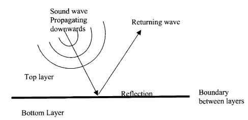
reflection. A typical boundary is shown schematically in Fig. 2. A layer atop
the
3o boundary is composed of rocks having a first density and elasticity values,
and a layer
below the boundary is composed of rocks having a second density and second
elasticity values. The differences between the densities and the elasticity
values
CA 02429875 2003-05-27
contribute to the amplitude of the reflected signal and thus carry information
about the
physical properties of the layers.
In standard seismic surveying each subsurface point is illuminated from
different directions, that is to say illumination angles, each direction
producing a
seismic section (constant angle section). As the sections show the same slice
they can
be superimposed or stacked. Stacking of the sections serves to de-emphasize
differences between the sections whilst similarities are enhanced. As the
differences
are most likely noise the stacking procedure tends to enhance the signal to
noise ratio.
The stacking procedure is known in the art as CMP stacking, and is a standard
method
to of enhancing the Signal to Noise ratio.
The multi- directional illumination enables analysis of the amplitude of
reflection at a given point as a function of the angle of illumination. Such
analysis is
carried out before stacking the data. Normally, when doing so, it is apparent
that the
amplitude decreases with increasing angle. That is to say, the greater the
angle of
illumination and consequently of reflection, the smaller the amplitude of the
received
signal. About 20 years ago it was discovered that when gas (and sometimes oil)
is
present in the layer, the amplitude behaves in an anomalous way, and in fact
tends to
increase as a function of the angle of illumination, and likewise of the
reflection
angle. The increasing amplitude phenomenon is known as an A.V.O. anomaly.
2o A.V.O. is an abbreviation for Amplitude Versus Offset.
Reference is now made to Fig. 3, which is a schematic diagram illustrating a
vertical section through the ground having a shale layer, a gas - sand layer,
and
another shale layer. Alongside each of the layer boundaries are shown a series
of
seismic traces illustrating signal amplitudes as the reflection angle
increases to the
right. The figure illustrates a basic A.V.O. model in the case of reflection
from a gas
- sand layer boundary. In the figure, 6 - Poisson's ratio, is given for each
layer as
representative of the elastic properties of the rock. As will be seen, at the
upper, shale
- gas, boundary, the amplitude increases from small negative to large
negative, and at
the lower, gas - shale, boundary, the amplitude increases from low positive to
high
3o positive.
A.V.O. anomalies are usually categorized into 4 different classes, three of
them are illustrated in Fig. 4, which shows for each class the changes in
amplitude of
a received signal as the reflection angle increases to the right:
CA 02429875 2003-05-27
Class I: Amplitude at zero angles is positive, and it becomes smaller as the
angle increases.
Class II: Amplitude at zero angles is close to zero, and it becomes more
negative as the angle increases.
Class III: Amplitude at zero angles is negative, and it becomes more negative
as the angle increases.
Class N: Amplitude at zero angles is negative, and it becomes larger (more
positive) as the angle increases.
Identification of A.V.O. anomalies has become a very important tool in oil and
1o gas exploration. When an A.V.O. anomaly exists, it is a strong indication
of the
presence of gas. An A.V.O. anomaly is not an absolute guarantee of oil or gas
but it
is sufficient to provide a very significant impact on the drilling success
rate.
The identification of A.V.O. anomalies within the seismic data is not a simple
task. Seismic 3-D surveys are very large and contain gigabytes and even
terabytes of
data. To perform A.V.O. analysis it is necessary to determine how the
amplitude at
each subsurface point behaves as a function of the reflection angle. In
classic seismic
processing (not for AVO purposes), the process of stacking serves to average
out the
amplitude and reduces the amount of information by a great amount. . For AVO
analysis, stacking is not an option as we seek to see the changes of amplitude
before
2o stacking. Instead of inspecting each AVO gather (data at a single surface
location as a
function of reflection angle) a lengthy and complex process, it is common to
create
what are known as A.V.O. attributes. A.V.O. attributes normally measure two
A.V.O.
parameters: The amplitude at zero reflection angles (Normal Incidence - NI),
and the
rate of change of amplitude as the reflection angle changes (Gradient - G).
A.V.O.
anomalies can be directly identified using these two attributes. Reference is
now
made to Fig. 5, which illustrates side by side a plot of amplitude at zero
reflection
angles (NI), on the left (a) and of gradient on the right (b).
In Fig. 5 color coding is used to indicate the amplitude of the signal. White
indicates small amplitude. Yellow to orange are normal amplitudes, red
indicates
large positive amplitude and blue indicates large negative amplitude. The
presence of
an A.V.O. anomaly is indicated wherever large amplitudes on the gradient graph
b)
correspond to small amplitudes on the NI graph a). The region marked by the
black
circle is such a region. Other regions of high gradient in b) correspond to
high NI on
CA 02429875 2003-05-27
4
the amplitude graph a) and therefore are disregarded. The region marked by the
circle
is the phenomenon that interests geologists. It indicates an A.V.O. anomaly
and thus a
high probability of the presence of gas.
Double plots of the kind shown in Fig. 5 can disclose A.V.O. anomalies,
howeverdue to the size of typical surveys it is not practical for the matching
to be
carned out manually by simple inspection. A geologist may often miss an AVO
anomaly when inspecting dual attribute datasets. Automated techniques are
called for
to enable the analysis of all AVO anomalies that are present in the dataset,
and
classify them according to the standard AVO classifications. Instead a
different
to technique known as A.V.O. crossplotting is used in standard automated or
partly
automated processes for identifying A.V.O. anomalies within a 2-D or 3-D
seismic
dataset. Crossplotting is a mathematical mapping process that can easily be
performed by computer and it provides a visual output. In AVO crossplotting,
the
same two A.V.O. attributes as used in the double plot, namely NI and G, may be
used.
Each subsurface point is mapped uniquely into a point in crossplot space,
which is
simply a two-dimensional space having, as axes, NI and G. Mapping of AVO
attribute data into the crossplot space is done as follows: For a given
subsurface
point, the amplitude (a) of the data point on the NI attribute is extracted;
also the
amplitude (b) from the G attribute is extracted. The data is then mapped onto
a single
2o point (a, b) in the crossplot space.
Reference is now made to Fig. 6, which is a simplified diagram illustrating a
crossplot space onto which a point (a,b), representing an NI value of a and a
G value
of b has been plotted. Mapping onto such a space transforms each class of an
AVO
anomaly onto a unique part of the crossplot space. Thus, regions in the
crossplot space
are uniquely associated with a specific AVO class, or of course with no class
at all,
for examplemud and rocks.
AVO crossplotting is a very useful tool for classifying and mapping AVO
anomalies. However, one disadvantage is that, unlike the double plotting of
Fig. 5,
the crossplot itself loses the location information of the point mapped. Thus,
in order
3o to make successful use of the crossplot, it is necessary to map AVO data
firstly to the
crossplot space as described above so that it can be categorized into its
anomaly class
or no anomaly, as appropriate. Then, once the point is categorized, the
categorization
is applied to the location from which the point is taken so that true
subsurface location
CA 02429875 2003-05-27
can be determined. Such a procedure is typically performed as part of a
computer
program, which maps from the crossplot space back to the attribute data, after
the data
has been classified in the crossplot space.
Ideally, it is possible to map each type of AVO anomaly to the identified
5 locations in the crossplot space as shown in Fig. 7, which is an idealized
version of
the cross plot space, showing the various regions that correspond with the
class 1-4
anomalies. The non-AVO anomaly data maps onto a line, the so-called no-oil or
mud
rock line which extends through the origin from upper left to lower right. The
line is
of negative slope to represent amplitude changes that decrease with reflection
angle.
Based on a-priori knowledge of how AVO anomalies map in the crossplot space,
as
represented in Fig. 7, it is possible to classify all seismic data points
according to a
corresponding AVO signature. Using AVO crossplotting, it is possible to map
all
AVO anomalies in 3-D. By following the above procedure, it is possible to
provide a
categorization for each data point automatically, even in a very large
terabyte range 3
D survey.
The problem with conventional AVO crossplotting
Unfortunately, reality is not as kind as Fig. 7 implies. Reference is now made
to Fig. 8, which is a graph showing how an A.V.O. crossplot appears for a real
large
data set. In reality the separation of AVO anomalies from the rest of the data
using
AVO crossplotting does not work in most cases. That is to say the data does
not
cluster around the different regions, but rather forms a difficult to classify
continuum.
Figure 8 is a crossplot of Normal Incidence (NI) versus Gradient (G) created
from a
3-D dataset recorded over a large gas field. All the data is concentrated
together and
there is no way of reliably discriminating between AVO and non-AVO effects. In
other words there is no formation of recognizable clusters that can be
separated from
one another.
Reference is now made to Fig. 9, which shows the regions of Fig. 7
superimposed upon the data of Fig. 8. In the dataset represented in Figs 8 and
9, there
is inter alia a class II AVO anomaly. Fig. 10 shows the result of selecting
the part of
the data associated with the class IT AVO, that is the data within the circle
II, and
tracing it back to the double graphs of Fig. 5 by highlighting. It can be seen
from Fig.
CA 02429875 2003-05-27
6
that indeed the A.V.O. zone is identified correctly, but many points outside
the
anomaly are also marked.
Furthermore, it is not clear, simply from looking at Fig. 9 that a type II
A.V.O.
anomaly actually exists in the data. All points which are pink in Figure 9 are
marked
5 pink on the attributes in Figure 10. The situation illustrated in Fig. 10 is
a very typical
situation. The reason for this behavior is discussed in several papers and is
explained
well by Ross, 2000 and by Keho, 2000, the contents of which are hereby
incorporated
by reference.
Reference is now made to Figure 1 l, which is a simplified diagram showing
1o an attribute only graph a) next to a cross-plot b) and illustrating how the
situation in
Fig. 10 in fact arises. A rectangle at the origin of a) represents data from a
class II
anomaly. The data from within the rectangle in a) that is to say data of the
clear class
II AVO anomaly, is mapped onto the crossplot b). It would be expected from the
analysis of Fig. 7 above that all of the data from within the rectangle is
mapped to the
class II anomaly region in b) but in fact this is not the case. The points are
drawn in
purple over the crossplot b). Fig 1 lb clearly shows that in fact very little
of the AVO
data maps into the class II zone. Rather most of the purple points are
distributed
throughout the main cluster of data points and in fact seem to form up
substantially
about a straight line crossing the origin and having a negative slope.
2o To understand how AVO anomalies actually map to an NI-G crossplot, it is
necessary to consider the effect of the original wavelet from which the
imaging data is
obtained and the effect of wavelet distortions with varying reflection angle.
The
wavelet is the shape of the source signal. A reflection from a subsurface
interface is
not a point reflection because the seismic signal has length in time. Hence,
each
reflection is contaminated by the shape of the source function - the wavelet.
When
taking into account the effect of the wavelet, a single NI-G event will not in
fact map
according to what is described in Figures 6 and 7, which turn out to be highly
simplified. The event actually maps, in an ideal case, to a line in the
crossplot space,
as illustrated in Fig. 12a to which reference is now made. The slope of the
line
3o distinctively defines an AVO signature. Figure 12b shows different points
along the
length of a wavelet which are all associated with a single AVO event. When
these
points are mapped to a crossplot as in Fig. 12a, they in fact form the line
referred to
above and shown in Fig. 12a.
CA 02429875 2003-05-27
7
Each type of AVO anomaly has a different slope, and the "No Oil" line is also
mapped distinctively to a specific line in the crossplot space as shown in
Fig. 13.
Figure 7 turns out to be an idealized picture that does not apply due to
wavelet effects.
A more realistic description of the AVO crossplot space and what is happening
in
practice is illustrated in Figure 13. In theory, then classification of data
points
according to the layout of Fig. 13 should provide an improved way of
recognizing
A. V.O.s.
A further complication of the above-described situation, and part of the
reason
that the data does not cluster around the lines of Fig. 13, is associated with
wavelet
to variations as a function of reflection angle. The wavelet variations lead
to distortions,
which affect the AVO attributes and typically distort the simplified picture,
causing a
scatter of points around the lines of Fig. 13. The lines as illustrated in
Fig. 13 thus
become no more than a basic trend for the data points rather than being a line
on
which the data points sit. The situation is illustrated in Fig. 14, which may
be viewed
as a more realistic version of Fig. 12. Fig. 14a shows a crossplot of points
shown in
the wave amplitude mapping of Fig. 14b. It will be noted that in Fig. 14b the
Normal
Incidence signal is different from the Gradient signal, and this is due to the
above-
described distortion. When mapping to the crossplot space of Fig. 14a the
distortion
leads to point scatter around the basic trend line. The extent of the
scattering is such
2o that it is difficult to resolve between the different trend lines, and thus
recognizable
clustering is not seen.
Figure 15 is a crossplot based on a real data set. It shows an AVO class I
anomaly colored pink superimposed on the full data shown in blue. It is clear
that the
AVO data has a different trend from the total data, that is to say it forms up
along a
different axis, and in fact the general data trends along the no-oil line
whereas the
class 1 anomaly data trends along the class 1 line. However, be that as it
may, the two
datasets in the crossplot space of Fig. 15 cannot be separated because they do
not
form distinct clusters. Without the superimposed color coding, which is to say
without prior knowledge, there is no way that the two trends could be spotted
from the
3o crossplot.
Figure 16 is another example taken from the same data set as Fig. 15, but
illustrating a Class II AVO anomaly. Again when color coded it is easy to see
that the
CA 02429875 2003-05-27
g
data lines up along two different trend lines, but without prior knowledge
there is no
way of identifying the trends.
Figure 17 is a similar display of non-AVO data. Here known non-anomaly
data is colored pink whereas general (unclassified) data is left blue. It is
clear that the
non-AVO data aligns with the general trend of the background data.
During a conventional crossplot procedure, each data point is mapped into a
single point on the crossplot space. Consequently, each AVO event, which spans
across a number of data points, is mapped to a number of locations in the
crossplot
space. Hence, theoretical division of the crossplot space to different AVO
regions
1o turns out to be unrealistic because there is no one-to-one mapping of
crossplot space
to AVO signatures.
There is thus a widely recognized need for, and it would be highly
advantageous to have an effective way of identifying AVO anomalies, which can
be
automated, and takes into account both the wavelet shape and the wavelet
variations
as a function of reflection angle.
SUMMARY OF THE INVENTION
According to one aspect of the present invention there is provided a method of
seismic data analysis comprising:
obtaining successive values from a plurality of seismic attributes, each
seismic
attribute comprising a respective property of a seismic reflection event,
grouping the values using a running window of a predetermined length,
identifying within each group of attribute values at least two parameters to
describe attribute value distribution therein, and
plotting said group of values as a single event using said parameters.
Preferably, identifying one of the said parameters comprises finding a trend
within said group.
Additionally or alternatively, identifying one of the said parameters
comprises
finding a maximum within said group.
Additionally or alternatively, identifying said at least two parameters
comprises finding a trend within said group for the said attributes and a
maximum
within said group for the said attributes.
CA 02429875 2003-05-27
9
Preferably, said plotting of said parameters comprises plotting said trend
against said maximum.
Preferably, a first of said attributes is an amplitude at zero reflection
angle.
Preferably, a second of said attributes is a gradient of change in reflection
amplitude against reflection angle.
The method may comprise sizing a running window substantially to be the
size of an originating wavelet, thereby substantially to group together
samples having
a corresponding originating wavelet.
The method may comprise reapplying said running window to obtain a next
point for plotting.
Preferably, said plotting comprises a first plotting stage for deriving said
parameters, said first plotting stage comprising:
plotting said values following grouping of separate points on a crossplot
space,
after crossplotting a point from one of the said attributes against a point
from the
second of the said attributes, said crossplot space having an origin, and
wherein said identifying said parameter comprises best-fitting a line through
said separate points and said origin.
Preferably, said plotting further comprises:
determining a trend and a group amplitude, said trend being an orientation
angle of said best fit line and said group amplitude being a length of said
best fit line
and
a second plotting stage of plotting said trend and said group amplitude
together as a point in an angle plot space of angle against length, said point
thereby
representing said group.
The method may comprise dividing said angle plot space into regions
representing different classes of AVO anomalies and a region representing no
anomaly.
The method may comprise color-coding said groups according to the
respective region in said angle plot space in which they fall.
The method may comprise the further stage of applying said color coding from
respective points in said angle plot space to corresponding values in a
seismic section
from which said points originate, thereby to provide a seismic image
containing an
indication of likely hydrocarbon location.
CA 02429875 2003-05-27
1~
The method may comprise the further stage of applying said color coding from
respective points in said angle plot space to corresponding values in a 3D
seismic
image from which said points originate, thereby to provide a 3D seismic image
containing an indication of likely hydrocarbon location.
Preferably, said windowing is such that each of said groups comprises values
received over a time interval, the method further comprising retaining for
subsequent
hydrocarbon identification only those of said groups having a rate of change
of one
attribute over time of one sign, and a rate of change of the other of said
attributes over
time of one predetermined sign.
Preferably, said plotting comprises a first plotting stage for deriving said
parameters, said first plotting stage comprising:
plotting said values following grouping of separate points on a crossplot
space,
after crossplotting a point from one of the said attributes against a point
from the
second of the said attributes, said crossplot space having an origin, and
wherein said identifying said parameter comprises best-fitting a line through
said separate points and said origin.
Preferably, said plotting further comprises:
determining a trend and a group amplitude, said trend being an orientation
angle of said best fit line and said group amplitude being a length of said
best fit line
and
a second plotting stage of plotting said trend and said group amplitude
together as a point in an angle plot space of angle against length, said point
thereby
representing said group.
The method may comprise dividing said angle plot space into regions
representing different classes of AVO anomalies and a region representing no
anomaly.
The method may comprise color-coding respective points according to the
respective region in which they fall.
The method may comprise a further stage of applying said color coding of said
points from said angle plot space to corresponding inputs in a seismic section
from
which said points originate, thereby to provide a seismic image containing an
indication of likely hydrocarbon location.
CA 02429875 2003-05-27
11
The method may comprise a further stage of applying said color coding of said
points from said angle plot space to corresponding inputs in a 3D seismic
image from
which said inputs originate, thereby to provide a 3D seismic image containing
an
indication of likely hydrocarbon location.
According to a second aspect of the present invention there is provided a
seismic imaging apparatus comprising:
an input for obtaining successive values from a plurality of seismic
attributes,
each attribute comprising a respective property of a seismic reflection event,
a windower for grouping the values using a running window of a
predetermined length,
a group parameterizer for identifying within each group of inputs group
parameters representative of value distribution within said group, and
a plotting unit for plotting said group as a single event using said group
parameter.
Preferably, said plotter comprises:
a crossplotter unit for plotting said attribute values per group as points on
a
crossplot space having an origin, and for best-fitting a line through said
points and
said origin.
Preferably, said group parameterizer is interactive with said crossplotter
unit
to identify an orientation angle and a length of said line and to provide said
angle and
said length to said plotting unit, said plotting unit further comprising an
angle plotter
to plot said angle and said length together as a point in an angle plot space
of angle
against length, thereby to plot said group as an individual event.
Preferably, said angle plotter is further operable to divide said angle plot
space
into regions representing different classes of AVO anomalies and a region
representing no anomaly.
The apparatus may be configured to color code said events according to the
respective region in which they are plotted by said angle plotter.
The apparatus may be configured to apply said color coding from said events
to respective values in a seismic section from which said events originate,
thereby to
enhance said seismic section by providing an indication of likely hydrocarbon
location.
CA 02429875 2003-05-27
12
The apparatus may be configured to apply said color coding from said events
to respective values in a 3D seismic image from which said values originate,
thereby
to enhance said 3D seismic image by providing therein an indication of likely
hydrocarbon location.
Preferably, each group comprises values received over a time interval, the
apparatus being further configured to use only those of said groups having a
rate of
change of one parameter over time of a first predetermined sign, and a rate of
change
of a second of said parameters over time of one predetermined sign.
Preferably, said plotter comprises:
a crossplotter for plotting said groups as a series of crossplot points on a
crossplot space having an origin, and best-fitting a line through said series
of crossplot
points and said origin.
Preferably, said group parameterizer is interactive with said crossplotter
unit
to identify an orientation angle and a length of said line and to provide said
angle and
said length to said plotting unit, said plotting unit further comprising an
angle plotter
to plot said angle and said length together as a point in an angle plot space
of angle
against length, thereby to plot said group as an individual event.
Preferably, said angle plotter is further configured to divide said angle plot
space into regions representing different classes of AVO anomalies and a
region
representing no anomaly.
Preferably, said angle plotter is further configured to apply color coding to
angleplot points according to the respective regions in which they fall.
The apparatus may comprise a seismic data analyzer associated with said
plotter and wherein said plotter is configured to apply said color coding to
respective
values in a seismic section from which said angleplot points originate,
thereby to
confer upon said seismic section an indication of likely hydrocarbon location.
The apparatus may comprise a 3D seismic data analyzer associated with said
plotter and wherein said plotter is operable to apply said color coding to
respective
values in a 3D seismic attribute from which said angleplot points originate,
thereby to
confer upon said 3D seismic attribute an indication of likely hydrocarbon
location.
Preferably, said windower is set to provide a window length to correspond to a
typical wavelet duration, thereby to group together in one window successive
values
originating from a single seismic wavelet.
CA 02429875 2003-05-27
13
According to a third aspect of the present invention there is provided a
method
of seismic data analysis to provide clustering of A.V.O. data into A.V.O.
anomaly
types, the method comprising:
obtaining successive values of a plurality of seismic attributes, each seismic
attribute comprising a respective property of a seismic reflection event,
grouping said values using a running window of a predetermined size into a
plurality of groups,
for each group identifying first and second parameters corresponding to said
group, and
plotting each group as a single event based on said group parameters, said
group parameters having been selected to cause clustering of said seismic
reflection
events on said plot according to the presence or absence of A.V.O. anomalies.
Unless otherwise defined, all technical and scientific terms used herein have
the same meaning as commonly understood by one of ordinary skill in the art to
which this invention belongs. The materials, methods, and examples provided
herein
are illustrative only and not intended to be limiting.
Implementation of the method and system of the present invention
involves performing or completing selected tasks or steps manually,
automatically, or
1o a combination thereof. Moreover, according to actual instrumentation and
equipment
of preferred embodiments of the method and system of the present invention,
several
selected steps could be implemented by hardware or by software on any
operating
system of any firmware or a combination thereof. For example, as hardwaxe,
selected
steps of the invention could be implemented as a chip or a circuit. As
software,
selected steps of the invention could be implemented as a plurality of
software
instructions being executed by a computer using any suitable operating system.
In
any case, selected steps of the method and system of the invention could be
described
as being performed by a data processor, such as a computing platform for
executing a
plurality of instructions.
BRIEF DESCRIPTION OF THE DRAWINGS
The invention is herein described, by way of example only, with
reference to the accompanying drawings. With specific reference now to the
drawings in detail, it is stressed that the particulars shown are by way of
example and
CA 02429875 2003-05-27
14
for purposes of illustrative discussion of the preferred embodiments of the
present
invention only, and are presented in the cause of providing what is believed
to be the
most useful and readily understood description of the principles and
conceptual
aspects of the invention. In this regard, no attempt is made to show
structural details
of the invention in more detail than is necessary for a fundamental
understanding of
the invention, the description taken with the drawings making apparent to
those
skilled in the art how the several forms of the invention may be embodied in
practice.
In the drawings:
FIG. I is a typical seismic section in which the vertical axis represents
depth
to and the horizontal axis represents surface distance, from which geological
features are
visible. FIG. 2 is a schematic diagram showing how seismic waves propagate and
reflect from the boundary between two layers.
FIG. 3 is a schematic diagram illustrating a vertical section through the
ground
having a shale layer, a gas - sand layer, and another shale layer, and showing
amplitude changes with reflection angle alongside for each boundary;
FIG. 4 is a schematic diagram showing three of the four classes of A.V.O.
anomaly;
FIG. S shows two seismic attribute graphs displaying the amplitude at zero
reflection angles (NI), on the left (a) and of gradient on the right (b);
2o FIG. 6 is a simplified diagram illustrating a crossplot space (right) onto
which
a point (a,b), representing an NI value of a and a G value of b has been
plotted;
FIG. 7 is an idealized version of the crossplot space, indicating how
different
A.V.O. anomalies theoretically map onto distinct regions ;
FIG. 8 is a crossplot of Normal Incidence (Nn versus Gradient (G) created
2s from a 3-D dataset recorded over a large gas field, from which it is
apparent that all
the data forms a single mass and there is no way of reliably discriminating
between
AVO and non-AVO effects;
FIG. 9 is a repeat of the crossplot of Pig. 8 onto which the regions of Fig. 7
are
superimposed;
3o FIG. 10 is a double plot of NI on the left a) and G on the right b),
showing the
actual distribution of points marked pink in Fig. 9 and supposedly belonging
to an
A.V.O. anomaly;
CA 02429875 2003-05-27
I5
FIG. 11 shows an attribute only graph a) next to a cross-plot b) and
illustrates
how the anomaly, marked by a small rectangle on plot 1, maps in crossplot
space;
FIGS. 12a and 12b are simplified schematic diagrams showing how the effect
of a wavelet on an AVO event (b) maps to a line in crossplot space (a).
FIG.13 is a simplified schematic diagram of a crossplot illustrating how
A.V.O. anomalies of the various classes theoretically map lines at different
angles
onto a crossplot, when wavelet effects are taken into account;
FIG.14 is a simplified schematic diagram showing how scatter within the
crossplot data points in a) of a wavelet event from b) spoils the theoretical
distribution
to of the anomaly classes and non-anomaly events of Fig. 13.
FIG. 15, FIG. 16 and FIG. 17 are crossplots of different events from a single
real dataset showing how, despite the scatter of Fig. 14, different types of
events,
although massed together, have different trend lines. FiG. 15 is of an AVO
anomaly
class I, FIG. 16 is of an AVO anomaly class II and FIG. 17 is of a non-AVO
event.
FIG. 18A is a simplified flow chart showing the construction of an angle plot
from dual seismic attributes according to a first embodiment of the present
invention;
FIG. 18B is a simplified block diagram showing a seismic data analysis device
according to a preferred embodiment of the present invention;FIG. 19 is a
crossplot
diagram showing the procedure described on stage SS of Fig. 18 for given
normal
incidence and gradient variations shown alongside;
FIG. 20 is an angleplot diagram illustrating regions on which different A.V.O.
anomaly events and no-anomaly events tend to cluster;
FIG. 21 shows two synthetic seismic gathers (traces that change with
reflection angle), a) for brine and b) for gas, used in a theoretical example
to illustrate
the effectiveness of the present embodiments for separating brine from gas;
FIG. 22 shows double plotting, Normal Incidence (22a) and Gradient sections
(22b) created from the two datasets of Fig. 21;
FIG. 23 shows crossplotting of the data of Fig. 22;
FIG. 24 shows an angle plot of the data of Fig. 22;
3o FIG. 25 is the angle plot of Fig. 24 onto which color coding that varies
with
trend angles has been superimposed;
CA 02429875 2003-05-27
16
FIG. 26 is the normal incidence trace of Fig. 22 onto which the color coding
obtained from the angle plot of Fig. 25 has been traced back. The trace back
clearly
identifies all classes of A.V.O. anomalies and separates them from the brine
data;
FIG. 27 is a crossplot showing an actual 3-D dataset of a seismic survey, the
survey containing a gas reservoir with a class II AVO anomaly, the dataset
being used
in a practical example to illustrate use of the present embodiments;
FIG. 28 is a conventional crossplot a) constructed from seismic section b).
Data corresponding to an actual anomaly is colored pink in both a) and b) and
the
failure of the anomaly data to cluster in a) is clearly seen.
1o FIG. 29 is an angle plot a) of the data in Fig. 28, showing clear
clustering of
the AVO anomaly data (marked pink) to the top right hand side of the plot, b)
showing the colored data traced back to the seismic section;
FIG. 30 shows a 3D seismic survey over which apparent anomaly data
determined from conventional cross plot is colored blue;
FIG. 31 shows the same 3D survey as Fig. 30, except that the cross plot data
was subjected to subsequent angle plotting, in accordance with a preferred
embodiment of the present invention. The location of the gas reservoir is
clearly
recognizable in the survey;
FIG. 32 is a schematic cross plot a) shown against amplitude b) to show how
two different AVO events cannot be distinguished on an angle plot;
FIG. 33 shows a seismic survey onto which anomalies determined from an
angle plot have been traced back by coloring, without constraining the data
prior to
angle plotting; and
FIG. 34 shows the seismic survey of Fig. 33 onto which the trace back is made
from angle plotting of constrained data, thereby to distinguish between AVO
anomaly
and non-AVO anomaly events.
DESCRIPTION OF THE PREFERRED EMBODIMENTS
3o The present embodiments provide a method and apparatus for
analyzing the incoming data per wavelet. Each wavelet rather than each data
point is
treated as a single event. Note that a wavelet here corresponds to a fixed
number of
data samples that encompass the length of a typical wavelet in the dataset.
The data
CA 02429875 2003-05-27
17
points of the wavelet are plotted in crossplot space and a best fit line is
fitted to the
data of the individual wavelet. The angle and length of the best fit line are
then
plotted in angle-plot space, where the plots are found to cluster into the
respective
A.V.O. anomaly classes and non-anomaly data. The double plotting procedure as
described above is referred to hereinbelow as the crossplot - angleplot
procedure.
The use of the crossplot - angleplot procedure as described above on seismic
imaging data according to the embodiments of the present invention allows for
separation, that is clustering of A.V.O. anomaly data from non-A.V.O. anomaly
data
in crossplot space. Effective separation of A.V.O. anomalies from the rest of
the data
1o enables direct detection of hydrocarbons in large seismic datasets.
The principles and operation of seismic imaging apparatus
according to the present invention may be better understood with reference to
the
drawings and accompanying descriptions.
Before explaining at least one embodiment of the invention in detail, it
is to be understood that the invention is not limited in its application to
the details of
construction and the arrangement of the components set forth in the following
description or illustrated in the drawings. The invention is capable of other
embodiments or of being practiced or carried out in various ways. Also, it is
to be
understood that the phraseology and terminology employed herein is for the
purpose
of description and should not be regarded as limiting.
Refernng now to the drawings, Figure 18A is a simplified flow chart showing
a crossplot - angleplot procedure according to a first preferred embodiment of
the
present invention.
Use of the crossplot - angleplot procedure allows for consideration to be
applied to each wavelet as a unit. Crossplot angleplots, that is angle plots
derived
from crossplots are preferably generated according to the procedure
illustrated in Fig.
18A. First of all input data is received in a stage S 1. Then the first
seismic trace is
selected at S2. Then, the first n data points from the trace, which correspond
to an
average wavelet length, in the manner mentioned above, are selected in a stage
S3.
The samples are then placed on a crossplot in a stage S4. Reference is now
made to
Fig. 19, which shows a cross plot of points from a single wavelet, against an
amplitude diagram of the NI and G data. A cross plot of the kind shown in Fig.
19
may be expected as the result of stage S4 and gives a plot for each sample in
the
CA 02429875 2003-05-27
Ig
wavelet of one sample attribute against the other. Returning to Fig. 18, and
in the
following two stages a derivation is made of group parameters which represent
group
behavior of theattribute values plotted in the crossplot. In stage SS a best
fit line is
drawn through the points and through the origin (0,0). Such a best-fit line is
shown
superimposed on the crossplot of Fig. 19.
In a stage S6, a measurement is made of two parameters of the best fit line:
the
angle (8) and the length of the line (R). The length R is proportional to the
maximum
NI amplitude along the given wavelet, and is therefore a measure of amplitude
of the
wavelet. The angle (8) is an overall trend of the individual angles of the
samples. The
1o n-sample one-wavelet event is now mapped, in a stage S7, to a single point
(R~ L7 8)
in angle-plot space. Angle plot space is a two-dimensional domain formed by
using
length as one axis and angle as the second axis. The plot is of the point (R,
~ A), that
is to say the parameters extracted from the line are the coordinates of the
angle-plot
space. The next (R, 8) point is generated by selecting the points representing
the next
wavelet and repeating the process. Selecting points that correspond to a
wavelet is
generally earned out by windowing successive samples using an n-sample window
where n is the average number of samples that correspond to a single wavelet.
A next
sample is then obtained by sliding the window n samples further along.
The sample attributes of NI and gradient, and the corresponding group
2o parameters are selected because of compatibility with existing equipment
and
software, and because they provide effective clustering. However, other
attributes
indicative of seismic reflection may also be used and corresponding group
attributes
be derived.
The crossplot - angleplot procedure is helpful because it maps different
classes
of AVO anomalies into distinct places in the angle plot space. Use of the best
fit line
allows for scatter to be averaged out and therefore the data events are able
to cluster.
Reference is now made to Fig. 20 which shows the angle plot space, in which
the
vertical axis represents angle, and the horizontal axis represents length.
Fig. 20 traces
out lines on which class I, II, & III anomalies tend to cluster. Fig. 20 also
shows the
3o no-oil line where non-hydrocarbon bearing points tend to cluster. The angle
plot
space thus enables the separation or clustering of AVO anomalies into
different
classes and distinguishes them from the no-oil data. Clustering on the angle
plot
space allows for clear separation of AVO anomalies from the rest of the data.
It is
CA 02429875 2003-05-27
19
pointed out that no separate line is traced for a class IV anomaly. This is
because the
lines for Class I and Class IV in fact coincide. Indeed, straightforward use
of the
angle plot crossplot does not allow for the separation of Class IV from Class
I.
However, as will be explained in greater detail below, a preprocessing stage
of
constraining the input data can allow for separation between Class I and class
IV.
As mentioned above, the best fit line in effect overcomes data scatter
effects.
It is noted that, by fitting a line in the above-described manner, a more
stable and
robust A.V.O. analysis is created. The procedure overcomes many of the
problems
associated with wavelet distortions. In addition the procedure only has a very
small
to sensitivity to n, the selected number of samples that represent a typical
wavelet. This
is because a small number of data points can quite effectively represent the
AVO
trend in the crossplot space. The effect of the processing window is reduced
even
more when constraining the angle-plot calculations as explained below.
Reference is now made to Fig. 18B, which is a simplified block diagram
illustrating a device for carrying out seismic imaging according to a
preferred
embodiment of the present invention. Device 20 comprises an input 22 for
receiving
data. The data received is, as described above, seismic data describing
amplitude
variation with reflection angle for each location. The data thus comprises a
series of
values, or a trace, for each of two attributes of seismic reflection events.
The data is
2o windowed by grouping unit 24, which is connected subsequently to the input
22. The
grouping unit 24 preferably windows the data to let in the number of samples
that
typically corresponds to a wavelet. The windowed data is passed on to a
plotter 26.
The plotter 26 comprises two parts, the first of which is a crossplotter 28
which forms
the cross plot, fits a best fit line and then determines the length and angle
of the best
fit line for each wavelet event, as described above. Subsequent to the cross
plotter is
an angle plotter 30, which plots the angle against the length as a single
point for each
event onto the cross plot space. The length and angle of the best fit line
thus serve as
parameters representing value distribution for each of the attributes over the
group,
and thus allow the entire group to be represented by just two co-ordinates - a
single
point. A color is assigned to the data point depending on where it appears in
the angle
plot space, and the color is applied, via trace back unit 32, to the original
seismic
section, so that the location of anomalies can be determined.
CA 02429875 2003-05-27
The crossplot - angleplot procedure is further explained by means of the
following non-limiting examples:
A Synthetic Example:
5 Reference is now made to Fig. 21, which shows seismic traces of synthetic
seismic data on which the crossplot - angleplot procedure was practiced. Fig.
21
shows two different seismic data sets which were computer generated, one for
brine
filled sand/shale contact, that is a set of "no-oil" data, and the other for
gas sand/shale
contact. Each of the data set therefore contains different clustering. Between
the two
to datasets there are four events representing AVO anomalies of classes I, II,
III, and IV
(top to bottom respectively in the figure). Elastic parameters for the AVO
data were
taken from Barnola and White, 2001. The objective of the example is to show
that
when using the crossplot - angleplot procedure it is possible to identify all
classes of
AVO anomalies and separate them from the no-oil data. The two datasets
displayed
15 in Fig. 21 are seismic traces as a function of reflection angle. The AVO
signature
indicates how the amplitude changes as a function of the reflection angle.
The brine data is presented in Figure 21 a and the gas data is presented in
Figure 21b. Reference is now made to Figure 22, which presents Normal
Incidence
(22a) and Gradient sections (22b) created from these two datasets.
Conventional NI-
2o G crossplotting of the data is shown in Fig. 23. Study of Fig. 23 in fact
shows
recognizable clustering of the data around different trend lines in the
crossplot space.
However it must be borne in mind that the clustering can only be seen because
the
synthetic data is highly idealized and is of limited size which does not
compare to the
data sets of a realistic survey, and in practice distortions, noise and super
position and
many data points would distort this idealized situation so district trend
lines would not
be recognized. An angle-plot of the same data is presented in Figure 24, to
which
reference is now made. The vertical axis is the angle axis (B) and the
horizontal axis
is the length (R). As discussed above, the length is proportional to the
maximum
amplitude of the event. Apart from clustering around the Y axis, it can be
seen that
3o the data points are organized along horizontal lines whose heights are
defined by the
angle associated with the event. The data clustered around the Y axis is small
amplitude data and generally indicates noise. Such data is preferably ignored
by the
subsequent analysis.
CA 02429875 2003-05-27
21
Color-coding techniques are often used in conjunction with classification of
seismic data, as here into different classes of AVO anomalies. Reference is
now made
to Fig. 25, which is a simplified diagram showing an angleplot space wherein
the
clustering regions are color-coded. The data is that of Figure 23, but the
space is
color-coded in stripes along the angle axis. The objective of the coloring is
to color-
map the AVO data according to the different data types. The small amplitude
area is
not colored, as it is mostly noise or insignificant data. Colors are applied
to the data
events according to the positions in which they are mapped on the angleplot
and then
are applied back to the originating data points on the attribute data.
Reference is now made to Fig. 26, which is a simplified diagram showing the
seismic trace of Fig. 22 to which color-coding from Fig. 25 has been applied
following angleplotting of the data. That is to say color-coding from the
angle plot is
traced back onto the data points as they originate from the seismic sections,
to allow
any anomalies found to be associated with actual locations.
Mapping of the points to the attribute data after color-coding, as shown in
Fig.
26, provides exact color-coded classification of the data according to
distinct A.V.O.
classes. It is noted that in Figure 26, all events in the brine part of the
section map to
green, which is consistent with brine saturation angle ranges and corresponds
to the
no-oil region. The gas sands are mapped onto four colors according to the four
2o A.V.O. classes. Note that in this idealized case anomalies of Class I and
Class IV are
nicely separated. In practice this separation is normally not achieved,
although see
the constrained data embodiment below. Generally Class I and Class IV
anomalies are
less distinctive because they are very close to the Mud-Rock region.
A field data example:
Figure 27 is a crossplot showing a 3-D dataset which in fact contains a gas
reservoir with a class II AVO anomaly. The field data example illustrates that
once
again, when using field data from a large survey, the situation is more
difficult to deal
with than the theory suggests. Nevertheless, clearly recognizable clustering
occurs.
In the crossplot of Fig. 27, identification of the anomaly is not possible
since
3o all the data is concentrated together. Figure 28 shows a crossplot in a) of
data taken
from a seismic section b). In both parts of the figure, that is, in both the
seismic
section and in the crossplot, data that originates from the gas reservoir is
marked in
pink. Fig. 28a) shows superposition of the gas field data, an AVO event, over
the rest
CA 02429875 2003-05-27
22
of the crossplot data. It is apparent that the gas field data has a different
trend in the
crossplot space. However, as in all of the previous cases, the data is
intermixed with
the remaining non-hydrocarbon indicating data, so that distinguishing
therebetween is
impossible.
Reference is now made to Figure 29, which presents the angle plot that
corresponds to the same data. The class II AVO anomaly is marked in pink and
is
enclosed in a rectangle. The anomaly data has clustered at the upper right
hand side
of the picture, away from the main mass of data. Thus the anomaly data is
clearly
distinct from the remaining data. It is clear that the AVO anomaly events are
clearly
to separated in the angle plot space.
Reference is now made to Figures 30 and 31, which are seismic scans on
which are displayed the same results in 3-D. Firstly, Fig. 30 shows detection
of class
II AVO anomalies using a conventional crossplot. Note the large scatter of
detected
points. Most of the detected points are artifacts, that is products of the
detection
process itself rather than genuine detections of hydrocarbons. In Figure 31
the same
data is detected using the crossplot - angleplot procedure of the present
embodiments
and clearly and distinctly shows class III AVO anomalies. The points showing
the
anomaly are indicated in blue. Fig. 31 clearly delineates the reservoir zone
from the
rest of the data.
Constraining angle cross~lot according to the AVO anomaly type:
Angle plotting of NI against G can be used to provide additional information.
It is possible to monitor the order, or time of receipt, of the different
samples that are
grouped together as being part of the same wavelet and determine whether the
various
sample values increase with time (or depth) or decrease therewith. In other
words, it is
possible to determine if the signal is positive and then negative, or the
reverse,
negative and then positive. Reference is now made to Fig. 32 which shows in a)
a
conventional crossplot taken for a set of points from a single wavelet. It is
possible to
constrain the data for example, by using only points where the signal is first
positive
3o and then negative. Such can help to differentiate between the two cases
displayed in
Figure 32b) which shows two cases of input groups, namely NI positive -
gradient
negative, the top case, and NI negative - gradient positive the bottom case.
The top
case and the bottom case map in the angle plot space to the same line, and
therefore
CA 02429875 2003-05-27
23
the angle plot fails to differentiate between them. By constraining the
calculations it
is possible to select the top case or the bottom case as desired. Once
selected, the
respective points may then be viewed separately, or colored separately and
then
viewed together. The ability to constrain the data between the two cases is
useful
because it makes it possible, inter alia, to distinguish between class I and
class IV
AVO anomalies, which as noted above are difficult to discerne from a standard
unconstrained angle plot.
The ability to constrain further permits use of the angle-plot construction to
detect specific events. Reference is now made to Fig. 33, in which color-
coding from
1o angle-plotting is used to highlight an AVO anomaly, shown in green, that
exhibits
reverse polarity. By constraining the calculation of the angle plot to
dNIldt>0 and
dGldt<0 where t is time, (or the order of the samples on the seismic trace) it
is
possible to improve angle plot classification. In Fig. 33, however, no such
constraint
has been applied. Reference is now made to Fig. 34 which shows the results of
applying the above constraint to the same data. It is clear that the AVO event
shown
in green is better defined and the location of the gas field is clearer.
It is appreciated that certain features of the invention, which are, for
clarity,
described in the context of separate embodiments, may also be provided in
combination in a single embodiment. Conversely, various features of the
invention,
2o which are, for brevity, described in the context of a single embodiment,
may also be
provided separately or in any suitable subcombination.
Although the invention has been described in conjunction with specific
embodiments thereof, it is evident that many alternatives, modifications and
variations
will be apparent to those skilled in the art. Accordingly, it is intended to
embrace all
such alternatives, modifications and variations that fall within the spirit
and broad
scope of the appended claims. All publications, patents and patent
applications
mentioned in this specification are herein incorporated in their entirety by
reference
into the specification, to the same extent as if each individual publication,
patent or
patent application was specifically and individually indicated to be
incorporated
3o herein by reference. In addition, citation or identification of any
reference in this
application shall not be construed as an admission that such reference is
available as
prior art to the present invention.