Note: Descriptions are shown in the official language in which they were submitted.
CA 02450810 2008-05-14
METHOD AND SYSTEM FOR CALIBRATING
LOCATION SYSTEMS
Field of the Invention
This invention relates to a method and system for calibrating a wireless
location
system (WLS) to enable the system to make highly accurate differential
measurements
such as time difference of arrival (TDOA) and frequency difference of arrival
(FDOA)
Background of the Invention
Wireless location systems are becoming increasingly important. An example is
disclosed in commonly assigned U.S. Patent Number 5,719,584 to Otto. Many
wireless
location systems use time difference of arrival (TDOA) calculations to
determine a set of
possible locations of a transmitter of a signal. The location is
mathematically determined,
as a hyperbola in two dimensions and a hyperboloid in three dimensions, from
the known
locations of two receivers and the difference in the measured time of arrival
(TOA) of the
signal at those two receivers. These systems use a variety of methods to
measure the
TOA of a signal at a receiver. All share, however, the common requirement that
the
clocks must either be synchronized or the offset between the clocks measured
and a
correction applied. The correction may be applied either directly to the
clocks or
mathematically to the calculations of time differences.
In many wireless location systems an attempt is made to synchronize the clocks
at
the receivers. A popular method is to use a clock source at each of the
receivers that is
synchronized to the global positioning system (GPS) transmissions. These
systems often
use an oscillator with good short-term stability to drive the clock and apply
a correction
-1-
CA 02450810 2003-12-11
WO 03/001686 PCT/US02/19329
based on the filtered difference between a received GPS timing
signal, which has good long term stability, and the clock.
These systems require a GPS receiver and GPS antenna with a
clear view of multiple GPS satellites.
Despite significant recent advances in these systems, the
root-mean-square (RMS) difference in time between two such
clocks may be as high as many tens to hundreds of nanoseconds
resulting in significant errors in location estimates,
particularly when geometric dilution of precision (GDOP) is
significant. Although synchronization of the clocks in this
manner may reduce TOA measurement errors due to clock offsets,
the system must also be carefully designed and calibrated to
ensure that delays in the receiver processing (both the signal
processing chain and the timing distribution chain) are fixed
and properly taken into account.
Some prior art systems use external calibration
techniques to correct clock offsets and to correct for other
variations in the receivers that may introduce TOA (and,
therefore TDOA) measurement'errors or errors in other measured
parameters such as frequency of arrival (FOA). In these
systems, receivers at known locations measure certain
parameters of a signal transmitted by a stationary reference
transmitter at a known location. The measured parameters are
then communicated to a common point where a processor
calculates offsets or adjustments that are either used to
adjust one or both of the receivers or are applied to the time
difference of arrival (TDOA) and/or frequency difference of
arrival (FDOA) calculations.
One such prior art wireless location system as disclosed
by U.S. Patent Number 6,184,829 to Stilp, reduces
instrumentation error by a calibration process where by
multiple wireless transmitters, such as cellular telephones,
are placed at known locations throughout the coverage territory
of the wireless location system. These phones make
-2-
CA 02450810 2003-12-11
WO 03/001686 PCT/US02/19329
transmissions, such as periodic registrations or page
responses, in a manner similar to any other phone. Because the
location and the theoretical TDOA values for any pair of
receivers are known a priori, the system can determine the
error in the TDOA measurements made in connection with a
particular pair of receivers.
In addition, because the phones are in fixed locations
and there is no Doppler shift, the theoretical FDOA value is
zero. Any measured error will be caused by drifts in the
oscillators at each of the receivers, changes in the
characteristics of analog components (e.g., the antennas,
cabling, and filters), and environmental factors. A correction
is applied to the computed TDOA and FDOA values in the digital
signal processing stages of the system.
These prior art external calibration systems have several
limitations. Periodic transmissions must be made by reference
transmitters at known locations and use system capacity that
might otherwise carry normal user traffic. If a long period
elapses between calibration and a subsequent TDOA and/or FDOA
measurement, then the calibration may be degraded by oscillator
offsets or changes in the receivers because to such things as
component parameter shifts are caused by temperature. Although
reducing the interval between reference transmissions improves
calibration, it is at the further expense of additional system
capacity. Another drawback is that multipath induced errors in
the time of arrival measurements made by the receivers during
calibration, i.e., when measuring the TOA/TDOA of the reference
transmissions, corrupt the TDOA calibration since straight-line
propagation from the reference transmitter to each receiver is
presumed.
Summary of the Invention
It is therefore an object of the present invention to
provide a method for external calibration of wireless location
-3-
CA 02450810 2003-12-11
WO 03/001686 PCT/US02/19329
systems that reduces or removes TDOA, FDOA and/or other
differential measurement errors arising from many sources
within the system.
It is another object of the present invention to provide
a system and method for calibrating wireless location systems
that is operable with reference transmitters of unknown
location that may be stationary or mobile with unknown vector
velocity.
It is yet another object of the present invention to
provide a system and method for calibrating wireless location
systems that may use normal user traffic transmissions from
unknown locations by stationary or mobile transmitters of
unknown vector velocity as reference transmitters thereby
minimizing the system capacity used for calibration and
reducing or eliminating degradation in calibration due to
system drift between the instant of calibration and the instant
of a measurement.
It is yet another object of the present invention to
provide a system and method for calibrating wireless location
systems that does not require a straight-line propagation path
from reference transmitters to receivers in order to accurately
calibrate TDOA or other difference measurements.
It is still another object of the present invention to
provide a system and method for calibrating wireless location
systems that is useful in systems using fixed, mobile or both
fixed and mobile receivers.
In accordance with the present invention, a system and
method determines the offsets of pairs of receivers used in
making TDOA, FDOA and/or other differential measurements of
signals. A transmitter at an unknown location can be is either
stationary or mobile with unknown vector velocity. A plurality
of fixed or mobile receivers of substantially known or
determinable location (and, in the case of moving receivers
making FOA measurements, of known vector velocity) receive the
-4-
CA 02450810 2003-12-11
WO 03/001686 PCT/US02/19329
signal from the transmitter via multiple paths due to
reflection and refraction of the signal by natural or manmade
objects in the vicinity of the transmitter and/or receivers.
The signal arriving at a receiver may or may not include a
straight-line path signal from the transmitter to that
receiver.
Each receiver measures the TOA and/or FOA or other
parameter of at least one, and in some embodiments several or
all, of the path signals believed not to be a straight-line
path. Although not necessary for purposes of calibration, it is
preferable that the receiver also measure the TOA and/or FOA of
the straight-line path signal, if present, for use in the
course of performing transmitter location and velocity
determination which may occur coincident with calibration.
A processor is operatively connected to the plural
receivers and selects a stationary natural or manmade object
that is believed to have reflected or refracted the signal to
each of the plural receivers and designates that object as a
proxy reference transmitter, also referred to in some instances
as proxy receiver because it "receives" a signal and reflects
or refracts the "received" signal end thus acts as a "proxy
reference transmitter" of the signal. Hereafter, the signal
reflected or refracted by that object to the plural receivers
may be referred to as a proxy reference transmission.
The location of the proxy reference transmitter is either
stored in a database operative with the processor or
determinable from information stored in the database such as,
but not limited to, aerial photographic imagery. The processor
then determines the differential measurement, for each
combination of receiver pairs receiving the proxy reference
transmission. In the case of FDOA, because the proxy reference
transmitter is a stationary object and the Doppler shift
imparted.by any motion of the transmitter relative to the proxy
reference transmitter is common to the reflected or refracted
-5-
CA 02450810 2003-12-11
WO 03/001686 PCT/US02/19329
signal at both receivers, the theoretical FDOA value is zero.
Any measured error will be due to drifts in the oscillators at
each of the receivers, changes in,the characteristics of analog
components (e.g., the antennas, cabling, and filters), and
environmental factors.
The processor may also calculate the theoretical TDOA
values for each pair of receivers receiving the proxy reference
transmission. The processor determines the expected TDOA from
the TOA of the proxy reference transmission at each of the
receivers; the locations of the receivers, which are either
known a priori and stored in the database or determinable from
information stored in the database; and the location of the
proxy reference transmitter, which is either known a priori and
stored in the database or determinable from information stored
in the database. The processor then either applies corrections
to the wireless location system equipment to correct the
offsets or applies corrections to the computed TDOA, FDOA or
other parameter values, obtained during normal system
operation, in the digital signal processing stages of the
system.
Brief Description of the Drawings
Other objects, features and advantages of the present
invention will become apparent from the detailed description of
the invention which follows, when considered in light of the
accompanying drawings in which:
FIGS. 1 and 2 illustrate a prior art Angle of Arrival and
Time of Arrival location determining system.
FIG. 3 is a diagram showing how a proxy receive site
having a proxy receiver, such as a water tower, can be
established for determining the location of a mobile unit using
only one receive site.
FIG. 4 illustrates a diagram similar to FIG. 3, but
showing the proxy receiver as a natural object, such as a hill.
-6-
CA 02450810 2003-12-11
WO 03/001686 PCT/US02/19329
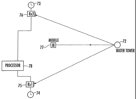
FIG. 5 illustrates how a proxy receiver can be used for
calibrating the clocks of first and second receive sites.
FIG. 6 is a diagram illustrating a multipath situation
caused by various buildings, illustrating the error that occurs
when the hyperbola and locus of points that are established if
the proxy receivers are considered to be direct line of sight
reflectors.
FIG. 7 illustrates the locus of points and error that
could occur when only an Angle of Arrival analysis is used with
proxy receivers.
FIG. 8 is a diagram similar to FIG. 7, but illustrating
the locus of points that are developed based on the system and
method of the present invention, such that the location of a
mobile unit can be established.
FIGS. 9 and 10 illustrate flow charts for an image
database routine that could be used with the present invention.
FIG. 11 is a layout of individual images of a building
and texture model that could be used with the present
invention.
FIG. 12 is another flow chart showing the type of process
that could be used with an image database routine shown in
FIGS. 9 and 10.
FIGS. 13 and 14 are diagrams, illustrating respective top
and isometric views, where the image database routine
determines the three dimensional aspects of proxy receivers and
buildings for height determinations and more accurate location
analysis.
Detailed Description of the Preferred Embodiments
The present invention will now be described more fully
hereinafter with reference to the accompanying drawings, in
which preferred embodiments of the invention are shown. This
invention may, however, be embodied in many different forms and
should not be construed as limited to the embodiments set forth
herein. Rather, these embodiments are provided so that this
-7-
CA 02450810 2003-12-11
WO 03/001686 PCT/US02/19329
disclosure will be thorough and complete, and will fully convey
the scope of the invention to those skilled in the art. Like
numbers refer to like elements throughout.
The present invention is advantageous and allows the use
of one receiver at a receive site to determine the location of
a mobile transmitting unit, such as a transmitting tag for a
car or individual wearing the tag, a mobile transceiver, or
other mobile unit. The system uses a proxy receiver (or
passive reflector) for Time of Arrival and/or Time of
Difference of Arrival calculations. Throughout the
description, the term proxy receiver is used for a
reflector/refractor located at a location called a proxy
receive site (PRS) and also used to describe any type of
passive reflector, such as a building, mountain, or hill, water
tower, or any other natural or man-made object that would
reflect and/or refract (or diffract) the signal from a
transmitting mobile unit or other radio transmitter to a
receiver that could be fixed or mobile. In some instances, the
proxy receiver reflects or refracts signals, such as for
calibration, and could be referred to as a reference proxy
transmitter. The term mobile unit can refer to any
transmitter, fixed or moving, for purposes of description.
Naturally, the signals can be radio frequency signals,
electromagnetic signals, or other signal types known to those
skilled in the art. For example, some water towers are an
excellent reflector of radio frequency signals, and the water
tower itself could be a proxy receiver. A large hill could be
a proxy receiver and a building, which not only would reflect
radio frequency signals, but also diffract/refract radio
frequency signals around a building corner edge.
The present invention is also advantageous because it
allows the use of a look-up table or geographical software
imaging database, such as the "RealSite" software as developed
by Harris Corporation of Melbourne, Florida, to be used to
-8-
CA 02450810 2007-10-10
assist in calculating the mobile location. The present invention is also
advantageous
because it allows use of the mobile transmitting unit for calibrating the
clocks of two
different receivers at two different receive sites, even though the location
of the unit may
be unknown. Two receivers could be used simultaneously to determine the
geolocation of
a mobile transmitting unit, even when multipath is present, as will be
described.
The present invention is advantageous over radio 10 fingerprinting, which has
limitations and drawbacks. The mobile is always presumed to be at one of the
grid points
and not at an intermediate location between grid points. The elevation of a
mobile also
changes, of course, such as in a building, resulting in errors in the location
estimate. The
accuracy depends on long transmissions and the motion of the mobile. The use
of narrow
band signals can also limit the ability to discriminate paths and the
extensive calibration
is required to generate a fingerprint grid database. The embedded mobiles will
also have
different fingerprints as compared to exposed units.
FIGS. 1 and 2 illustrate a basic geolocation system and method using an Angle
of
Arrival (AOA) and Time of Arrival (TOA) system.
With reference to FIG. 1, the geolocation system uses plural fixed receive
sites
30, each connected to a centralprocessing unit 32 through conventional
communication
links 34.
A target unit (or unit to be geolocated such as a mobile 30 transmitting unit)
36
transmits a radio frequency signal, which may be an RF signal, an
electromagnetic signal,
or various types, to plural of the receiving stations.
In operation, the receive sites (or "receiving stations") 30 each receive the
signal
from the target unit 36 and send a
-9-
CA 02450810 2003-12-11
WO 03/001686 PCT/US02/19329
communication concerning that signal reception to the central
processing unit 32. Depending upon the structure of the
system, the central processing unit 32 may use the Angle of
Arrivals of the signal at the receive sites 30 or the Times of
Arrival of the signal at the receive sites 30 or other
conventional means to determine the geolocation of the target
unit 36. With a proper system design, the central processing
system 32 can simultaneously determine the geolocation of
several target units 30 located within the receiving range of
plural of the receiving stations 30.
With reference to FIG. 2, the system requires only two
receiving stations RS 30 and RS 40 to determine the geolocation
of a target unit 36. Each receiving location 30 receives a
signal from the target unit 36 and determines both the Angle of
Arrival and the Time of Arrival of the signal, which is
provided, in turn, to the central processing unit 32 through
conventional communications links 34. At the central
processing unit 32, the difference in Time of Arrival
information between two stations may be used to compute a locus
of points along a curve 50 at which the target unit 36 may
exist (i.e., the locus of points from which a signal would have
the determined Time Difference of Arrival between the given two
receiving stations 30). The precise point along the curve 50
at which the target unit 36 is determined to be located is
obtained from the intersection of the curve 50 with the bearing
lines (from the Angles of Arrival) AOA1, AOA2 from either one
of the receiving stations, RS30 or RS40.
Ideally, the curve 50 and the bearing lines AOA1 and AOA2
all intersect at a single point coincident with the location of
the target unit 36. In practice, however, errors in the TOA
measurements will displace the curve and/or errors in the AOA
measurements will displace one or both of the bearing lines
such that multiple points of intersection occur, as is shown,
thus leading to uncertainty in the location of the mobile unit.
-10-
CA 02450810 2003-12-11
WO 03/001686 PCT/US02/19329
In this type of system in which multiple receiving sites
are needed to provide geolocating (and/or communications)
coverage throughout a geographic area, such as in a low power
personal communication systems, which cover a wide geographic
area, only two receiving stations are required for contact with
a target unit at any time in order to provide complete
geolocating coverage. If in a given system, the signals from a
target unit are received at more than two receiving stations,
the processing unit can combine the bearing lines and the
curves using any vectora combination scheme known to those
skilled in the art.
Depending upon the local terrain conditions and other
factors, the central processing unit 32 may: weight the signals
from some receiving sites more heavily than others; weight the
signals in proportion to a metric of signal quality such as
signal-to-noise ratio of the received signals; weight more
heavily the positions determined from receiving stations closer
to the determined location of the target unit; and/or eliminate
some of the bearing lines and/or curves for outlying estimates,
and thus, weighting more heavily the curves determined from the
TDOA determinations. The central processing unit could
determine the geolocation of the target unit using a moment of
inertia calculation based on the weighted estimates of
position. Indeed, the central processing unit may determine
the geolocation of the target unit using a moment of inertia
calculation based on the weighted estimates of position.
There now follows a general overall description of the
present invention, followed by a detailed description relative
to drawing FIGS. 3-13. The present invention is advantageous
and determines the location of a transmitter. A transmitter to
be located transmits a signal and a receiver receives the
signal from a transmitter and measures the Time of Arrival of
plural of the multiple path signals from a transmission. One
-11-
CA 02450810 2003-12-11
WO 03/001686 PCT/US02/19329
or more natural or manmade objects reflect and/or refract
portions of a signal from the transmitter toward the receiver.
A database could be used to contain locations of, or
information that may be used to calculate the locations of, the
receiver and one or more, but necessarily all, of the natural
or manmade objects. A processor is operative with the receiver
and the database and estimates the location of the transmitter
or determines a set of points representing potential locations
of the transmitter. This can be accomplished by either
selecting one object, the location of which is either stored in
the database or may be determined from information in the
database, as a proxy receiver, or selecting plural objects, the
locations of which are either stored in the database or may be
determined from information stored in the database, as plural
proxy receivers.
The location of each proxy receiver is determined from
information in the database. The location of the receiver can
be determined from information stored in the database and then
calculated with a straight-line signal propagation time from
each proxy receiver to the receiver. The Time of Arrival of
the signal at each proxy receiver can be calculated by
subtracting the proxy-receiver-to-receiver signal propagation
time for that proxy receiver from the estimated Time of Arrival
at the receiver of that path estimated to have been reflected
or refracted from the proxy receiver.
One or more sets of points can be generated with each
such set representing potential locations of the transmitter
corresponding to the difference in Time of Arrival of the
signal and a proxy receiver from the Time of Arrival of the
signal at either another proxy signal or the receiver.
A source or sources of additional information are
operatively connected to the processor and may be necessary or
desirable for use by the processor by (a) selecting a proxy
receiver or plural receivers, (b) as additional inputs to a
-12-
CA 02450810 2003-12-11
WO 03/001686 PCT/US02/19329
multilateration calculation or (c) determining the waiting to
be applied to points or sets of points and combining them to
produce a refined set of points.
The transmitter can be a mobile transmitting unit and the
receiver can be a mobile receiver. The transmitter can also be
located indoors, as well as the receiver. At least one proxy
receiver could also be indoors.
The signal could be one of an electromagnetic signal, a
radio frequency signal, an optical signal, or acoustical
signal. The signal can be generated by or at the transmitter,
and can be modulated in accordance with any combination of
parameters such as, but not limited to, the identification
number of the transmitter, data stored at the transmitter, or
the status of sensors or switches at the transmitter. The
transmitter can also transmit the signal in response to any
combination of states of an internal timer, motion detector, or
other sensor or algorithm. The signal can also be transmitted
in response to an external command or event such as, but not
limited to, a button or switch closure, or the reception or a
trigger or command signal. The signal could be the
retransmission of a signal received at the transmitter and
modified in any combination of ways such as, but not limited
to, amplitude modulation, phase modulation, frequency
translation, time shifting, spectral inversion, polarization or
any other such transformation, or modulation as may be used by
those skilled in the art. It can also be modified in
accordance with any parameter such as, but not limited to, the
identification number of the transmitter, data stored at the
transmitter or the status of sensors or switches at the
transmitter.
The transmitted signal can be a conventional
communication system signal, but not limited to, cellular
telephone, specialized mobile radio, mobile data or personal
communications. This transmitted signal can also have a band
-13-
CA 02450810 2003-12-11
WO 03/001686 PCT/US02/19329
width such as, but not limited to, narrow band, wideband,
composed of portions with band widths or composed of portions
in non-contiguous frequency bands. The signal can also be a
spread spectrum signal in any modulation format or combination
of modulation formats such as, but not limited to, direct
sequence, frequency hopping, non-linear frequency, linear
frequency (chirp), co-chip key in, code position, pulse
position or impulse. It can include a straight-line path
signal from the transmitter to the receiver and can include a
straight-line path signal from the transmitter to the receiver.
The at least one object can include a natural landmark or
earth elevation, as a proxy receiver, or another man-made
structure such as a building, portion or a building, water
tower, portion or a water tower, communications or utility
power pole or portions of a communications or utility power
pole.
When a database is used with the present invention, it
can contain two-dimensional or three-dimensional location data.
It also can contain information that may be used to calculate
two-dimensional or three-dimensional locations of an object.
The database can include a digitized map, digitized imagery,
electromagnetic imagery, radio frequency imagery, optical
imagery or acoustical imagery. The imagery can be the same
frequency band as the transmitted signal or can be in a
frequency band different from the transmitted signal.
In another aspect of the present invention, as noted
before, there may be additional information or there may not be
additional information for processing. This source of
additional information could be the receiver, the Angle of
Arrival at the receiver or the earliest arriving signal path,
such as the azimuth and elevation. The additional information
could include the Time of Arrival at the receiver of the
earliest arriving signal path or the Angle of Arrival at the
receiver of a signal path estimated by the processor to have
-14-
CA 02450810 2003-12-11
WO 03/001686 PCT/US02/19329
been reflected or refracted by a proxy receiver. This Angle of
Arrival can include the azimuth and elevation.
The additional information can also include the Angles of
Arrival at the receiver of plural signal paths estimated by the
processor to have been reflected or refracted by plural proxy
receivers. The Angle of Arrival of one or more of the plural
reflected or refracted signal paths can be both azimuth and
elevation. The additional information can also include, in any
combination, parameters of the received signal or portions
thereof, such as, but not limited to: signal strength, Angle
of Arrival, Time of Arrival, multipath profile or roundtrip
signal flight time.
The source of additional information could also be the
database. This additional information could include
information collected from prior transmission by the
transmitter. The additional information can include prior
estimates of transmitter location in two or three dimensions.
There could also be plural sources of the additional
information.
The processor can determine a set of potential locations
of the transmitter corresponding to the difference in Time of
Arrival of a signal at a proxy receiver and the Time of Arrival
of one other signal path at the receiver. This other signal
path can be the earliest arriving signal path at the receiver.
The processor can also determine a set of potential locations
of the transmitter corresponding to the difference in Time of
Arrival of a signal path at a first proxy receiver and the Time
of Arrival of a signal path at the second proxy receiver. The
processor can determine a set of potential locations of the
transmitter corresponding to the intersection of (a) the set of
potential locations of the transmitter corresponding to the
difference in Time of Arrival of a signal path at a proxy
receiver as determined by the Time of Arrival of the signal
path reflected or refracted by that proxy receiver and the Time
-15-
CA 02450810 2003-12-11
WO 03/001686 PCT/US02/19329
of Arrival of one other signal path at the receiver with (b) a
set of potential locations of the transmitter corresponding to,
the Angle of Arrival of the other path at the receiver.
This other signal path can be the earliest arriving path
at the receiver and the Angle of Arrival can include both
azimuth and elevation.
The processor can also determine a set of potential
locations of the transmitter that is the intersection of (a)
the set of potential locations of the transmitter corresponding
to the difference in Time of Arrival of a first signal path at
a first proxy receiver as determined by the receiver and a
second signal path at a second proxy receiver as determined by
the receiver with (b) the set of potential locations of the
transmitter corresponding to the Angle of Arrival at the
receiver of a third signal path.
The third signal path can be the earliest arriving signal
path at the receiver. The Angle of Arrival can be determined
in both azimuth and elevation. The processor can determine a
refined set of potential locations of the transmitter by
waiting and combining in any combination: points within a set
of points; plural sets of points; and sets of points derived
from previous transmissions for previously-refined sets of
points.
The combined points can include the intersection of
plural sets of points or one or more of the points weighted
more heavily than others of the points. A refined set of
points is determined by vector combination of points in two
dimensions. A refined set of points is determined by vector
combination of points in three dimensions.
The system can include a plurality of receivers for
receiving the signal, each of which measures the Time of
Arrival of plural of the multipath signals from a transmission.
The plurality of the receivers includes two receivers and the
processor determines a set of potential locations of the
-16-
CA 02450810 2003-12-11
WO 03/001686 PCT/US02/19329
transmitter corresponding to the difference in Time of Arrival
of a signal at a first proxy receiver as determined from the
Time of Arrival of the signal reflected or refracted by the
first proxy receiver at a first receiver and the Time of
Arrival of the signal at a second proxy receiver as determined
by the Time of Arrival of the signal reflected or refracted by
the second proxy receiver at a second receiver.
The processor can determine a set of potential locations
of the transmitter corresponding to the difference in Time of
Arrival of a signal at a proxy receiver as determined from the
Time of Arrival of the signal path reflected or refracted by
that proxy receiver at a first receiver and the Time of Arrival
of a signal at a second receiver. This second receiver can be
the Time of Arrival of the earliest arriving signal path at the
second receiver. The earliest arriving signal path at the
second receiver is the straight-line path from the transmitter
to the second receiver.
The processor can determine a refined set of potential
locations of the transmitter by combining plural sets of
potential locations of the transmitter. This set of combined
points can be an intersection of plural sets of points and can
be determined by a vector combination of weighted sets of
points in two dimensions. The combined set of points can be
determined by vector combination of weighted sets of points in
three dimensions.
The receiver can receive a signal from a transmitter and
measure the Time of Arrival of plural of the multiple path
signals with a signal channel receiver. It can receive a
signal from a transmitter and measure the Times of Arrival of
plural of the multiple path signals in a plural channel
receiver. One of the plural channels can be operative with a
directive antennae pointed in a radial direction along which
lies at least one object that may be selected as a proxy
receiver. There can be plural directive antennas, each of
-17-
CA 02450810 2003-12-11
WO 03/001686 PCT/US02/19329
which is pointed in a radial direction along which lies at
least one object that may be selected as a proxy receiver and
each of which is operative with a separate channel of the
receiver.
This directive antennae is a sector of a multiple sector
antennae and can be a conventional communications system such
as, but not limited to: mobile telephone, specialized mobile
radio, or a mobile data. The plural, but necessarily all,
channels of a receiver are each operative with one or more
elements of a plural element antennae such that those plural
channels include a phased array receiver and can include a
linear array or two-dimensional array that is directive
substantially in a direction parallel to the plane of the
array. It can also be directive substantially in a direction
perpendicular to the plane of the array. The plural elements
can be operative with the plural channels and include a phased
array receiver that includes a three-dimensional array. The
plural elements can be operative with the plural channels and
include a phased array receiver that are of the same
polarization. The receiver can also be plural co-located
receivers with substantially co-located antennas, including a
plural channel receiver that is a phased array receiver.
The Time of Arrival of a signal path can be measured on
the linear or a vector combination of weighted signals from
plural receiver channels. The weights for the channels can be
chosen to reduce or null signals from paths other than the path
for which the Time of Arrival is measured. Polarization of the
antennae elements can feed some of the channels that differ
from the polarization of the antennae elements feeding other of
the channels. This other information can include information
about or gathered by the transmitter such as, but not limited
to: configuration (e.g., body worn, vehicle mounted, attached
to large asset, attached to hand-carried asset); elevation;
barometric pressure; temperature; location (e.g., outdoors,
-18-
CA 02450810 2003-12-11
WO 03/001686 PCT/US02/19329
indoors, on road); or velocity. The other information is
transmitted by the transmitting unit.
The method and system for calibrating a wireless location
system such as receivers used for locating a transmitter is
advantageously set forth. A signal can be transmitted from an
unknown location. A signal is received and measured at each of
a first and second receiver. An error value is determined
based on the difference between an expected difference between
parameter values and the actual difference between measured
parameter values such that the expected difference is
determined using information from the database and other
sources.
The error value is used to apply corrections to the
wireless location system equipment to minimize the errors in
subsequent measurements and/or apply corrections to any prior,
concurrent or subsequent measurements of the parameter.
Throughout this description, the proxy reference transmitter
can be a natural or man-made object as described before. It
can also be described as the proxy reference receiver or proxy
receiver that receives and reflects or refracts signals, thus
acting similar to a transmitter. Any error value can also be
based on the difference between an expected frequency
difference of arrival and the actual frequency difference of
arrival.
FIG. 3 illustrates a first aspect.of the present
invention, wherein the processor has selected a proxy receiver
60 located at a proxy receive site (PRS) which is believed to
be a reflector/refractor of signals from the transmitter to the
receiver, as in a typical multipath example. The Time of
Arrival for the proxy receiver equals the Time of Arrival of
the reflected or refracted path at the receiver site (RS) minus
the proxy receiver site to receiver site propagation time.
Although a water tower is the illustrated proxy receiver 60, it
should be understood that a proxy receiver located at a proxy
-19-
CA 02450810 2003-12-11
WO 03/001686 PCT/US02/19329
receiver site can be any type of reflector or refractor such as
the flat, reflective side of a building, the edge of a
building, a geographic landmark such as a large hillside, a
tree in the middle of a prairie, a communications or utility
tower, bridge or other reflector/refractor objects as suggested
and known by those skilled in the art.
In the specific illustrated aspect shown in FIG. 3 the
receive site (RS) 62 includes a receiver (R1) and includes an
omnidirectional antenna 63 that receives a signal from the
mobile transmitting unit 64. The associated processor 65 is
operatively connected to the receiver and determines the Time
of Arrival of the earliest arriving path signal incident on the
omnidirectional antenna using standard processing algorithms
known to those skilled in the art. The computer or other
processor of the type known to those skilled in the art 65
could be located at the receive site or connected via
communication lines 66 at a distance from the receive site. In
one aspect of the invention, a unidirectional antennae 67 can
be pointed directly at the water tower 60 and positioned at the
receiver site and also operatively connected to the receiver.
The receiver determines the Time of Arrival of the reflected or
refracted path signal incident upon the directional antenna.
The processor 65 determines the Time Difference of Arrival
between the line of sight signal transmitted to the receive
site from the mobile transmitting unit and the reflection from
the water tower, i.e., the proxy receiver 62. This value is
determined based upon the known location of the water tower as
stored in the database.
FIG. 5 illustrates the use of a proxy receiver 72 such
as a water tower, for calibrating respective clocks 73, 74 at
respective receiver 1 (75) and a receiver 2(76). Calibrated
clocks can be critically important in some applications for
determining the location of mobile units, especially when
multipath considerations are taken into account, as in the
-20-
CA 02450810 2003-12-11
WO 03/001686 PCT/US02/19329
present invention. Even if the mobile transmitting unit 77 is
at an unknown location, this unit can transmit to the proxy
receive site from that unknown location against the reflector,
acting as a proxy receiver 72, i.e., the water tower, in the
present example. Each receive site, such as the illustrated
receiver 1 and receiver 2, receive the reflection off the water
tower acting as the proxy receiver. The receive sites are at
fixed, known locations and the distance and angle to the water
tower are known. A central processor 78 is operative with both
receivers could receive the Time of Arrival and Angle of
Arrival information from the two receivers. Through
appropriate algorithms and calculations, the differences are
established, and the offset from the two clocks 73, 74 can be
removed using standard processing algorithms, as known to those
skilled in the art. This calibration is advantageous over
prior art techniques where known transmitters at known
locations are used to transmit a signal.
FIG. 6 illustrates a situation where multipath is present
such as in an urban environment where various buildings, Bl-B5
for example, are present. A transmitter, such as a mobile
transmitting unit 64, is located behind building B3, which is
also positioned central to the four other buildings B1, B2, B4
and B5. Receiver 1(Rxl) is located south of the buildings and
receiver 2(Rx2) is located north of the buildings. A
processor is operative with the receivers.
As illustrated, no direct line of sight communications
are made from the transmitter, e.g. mobile transmitting unit 64
to receiver 1(Rxl) or receiver 2(Rx2). Instead, the first
receiver (Rxl) receives reflected first and second arriving
signals (PR1-1, PR1-2) from buildings B1 and B5, while receiver
2(Rx2) receives a signal as a first arriving path from
building 2, which could be a as proxy receiver. Thus, the
Angle of each transmission from a proxy receiver formed by the
respective buildings and the signal and its Time of Arrival can
-21-
CA 02450810 2003-12-11
WO 03/001686 PCT/US02/19329
be determined. If the time difference between the arrival of
the signal at the second receiver (Rx2) and the earliest
arriving of the two signals at the first receiver (Rxl) is
taken, then the hyperbola line drawn at 80 is formed. If the
system took the Time Difference of Arrival of the earliest path
at each site (Rx1 or RxZ), and the angle from one or the other
of the sites, and the two locations are calculated, neither
would be correct as illustrated by the two stars 81, 82 shown
at A2/TDOA and Al/TDOA. The first star 81 shows angle two with
the Time Difference of Arrival and the second star 82 shows
angle one and the Time Difference of Arrival. The hyperbola
line drawn at 84 illustrates the correct hyperbola if there
were only direct line of sight communications. It is evident
that there are three sites PR1-2, PR2-2, and PR1-1 showing
squares for the proxy receivers and the curves are calculated
with this ambiguous solution.
FIG. 7 illustrates a similar situation where an improper
line 85 forming a potential locus of points 'is established when
mobile transmitting unit 64 is located between buildings B3,
B31, and only Angle of Arrival considerations are used with
line of sight values AS2/TD and Al/TD. Improper locations are
shown by stars 86 are based on the Time Difference of Arrival
calculations.
In accordance with the present invention, the location,
i.e., the latitude and longitude, of a reflector/refractor
located at the proxy receive site and forming a proxy receiver
along each of the arriving paths is determined via a look-up
table or feature extraction from a geographic image database,
such as the software "RealSite,' as developed by Harris
Corporation of Melbourne, Florida. The geographic database
could include data relating to the natural and man-made features
in a specific area, including data about buildings and natural
land formations such as hills.
-22-
CA 02450810 2003-12-11
WO 03/001686 PCT/US02/19329
For example, a database could include information about a
specific area, from where a signal emanates, includes a tall
building or water tower, being a passive reflector of radio or
other signals, and thus act as a proxy receiver. A look-up
table could have similar data and the system processor would
interrogate and determine from the look-up table the type of
buildings, natural features, etc. from where a signal emanates
to determine what features could be proxy receivers. The use
of the geographic database with a look-up table or the use of
feature extraction software is advantageous and allows the
system to determine if a direct line of sight path or a
reflected and/or refracted path is a source of the signal.
The system could use the feature extraction software or
query the look-up table to determine that the layout shown in
FIGS. 6 and 8, which includes five buildings, forming the
reflections and refractions as illustrated by the signal lines
among the buildings. For the example shown in FIGS. 6 and 8, a
two-dimensional database would be required. It is possible,
however, to also use a three-dimensional database in order to
take into consideration elevation concerns.
In this type of system, where knowledge of
reflected/refracted and line of sight signals could be
determined by feature extraction, or the look-up table used,
the location estimate could be calculated using weighted Time
Difference of Arrival curves and Angle of Arrival bearings.
The weights may depend on the number of parameters including
the number of receive sites that receive a signal, such as
receiver 1(Rxl) and receiver 2(Rx2), as illustrated. Other
weights could depend on the number of paths received at a site
(or in total), as well as the geometry, i.e., relative
locations of the receive sites (Rxl and Rx2), the proxy receive
sites (PRS) and the mobile transmitting unit 64. An estimated
signal to noise (S/N) ratio for each path and the location
estimates from prior transmissions could also be used. The
-23-
CA 02450810 2003-12-11
WO 03/001686 PCT/US02/19329
location estimate could also be dependent on the weights from
the Angle of Arrival and Time of Arrival estimates.
The process may be iterative. For example, if a mobile
unit 64 transmits a signal that is received at two receive
sites, the system could calculate three estimates of the
location using the receive site Time of Arrival and Angle of
Arrival. For example, the following three calculations could
be used: 1) the Angle of Arrival of receive site 1 and the
Angle of Arrival of receive site 2; 2) the Angle of Arrival
from receive site 1 and the Time Difference of Arrival of
receive site 2 minus receive site 2; and 3) the Angle of
Arrival for receive site 2 and Time Difference of Arrival for
receive site 1 minus receive site 2.
If the variation between the estimate is small, then a
weighted combination could be used. If the variation is large,
proxy receive sites could be substituted for one or both
receive sites and the system could reiterate the calculations.
Plural proxy receivers could be used for a single Angle of
Arrival in this iterative process. The image data obtained
from feature extraction software, such as from RealSite, could
be used to validate an answer.
For purposes of illustration, a brief description of an
example of a feature extraction program that could be used with
the present invention, such as RealSite, is set forth.
Naturally, many different types of feature extraction software
are available to one skilled in the art, and can be used in the
present invention to determine the various features that could
act as passive reflectors or refractors and be proxy receivers.
Although the present example will be described relative to
texture software, radio frequency reflective values could also
be used instead of texture values as reflected optical effects.
The database could also be used with two-dimensional or three-
dimensional feature imaging. Optical reflectivity can be used
-24-
CA 02450810 2007-10-10
for finding building plane surfaces and building edges, which aid in
determining the
location of proxy receivers.
For purposes of description, a high level review of feature extraction using
RealSite is first set forth. This type of feature extraction software can be
used to
validate results and find the natural and man-made proxy receivers and can be
used in
two-dimensional and three-dimensional modes.
RealSite allows the creation of three-dimensional models in texture mapping
systems and extends the technology used for terrain texturing to building
texture by
applying clip mapping technology to urban scenes. It can be used to determine
optical reflectivity values and even radio frequency reflectivity for
determining proxy
receivers and determining the latitude and longitude of such proxy sites.
It is possible to construct a single image of a building from many images that
are
required to paint all the sites. Building site images can fit into a composite
image of
minimum dimension, including rotations and intelligent arrangements. Any
associated
building vertex texture coordinates can be scaled and translated to match new
composite
images. The building images can be arranged in a large "clip map" image,
preserving the
horizontal relationships of the buildings. If the horizontal relationships
cannot be
accurately preserved, a "clip grid" middle layer can be constructed, which can
be used
by the display software to accurately determine the clip map center.
At its highest level, the system creates a packed rectangle of textures for
each of a
plurality of three-dimensional objects corresponding to buildings to be
modeled
-25-
CA 02450810 2003-12-11
WO 03/001686 PCT/US02/19329
for a geographic site. The system spatially arranges the
packed rectangle of textures in a correct position within a
site model clip map image. The texture mapping system can be
used with a computer graphics program run on a host or client
computer having an OpenGL application programming interface.
The location of a clip center with respect to a particular x,y
location for the site model clip map image can be determined by
looking up values within a look-up table, which can be built by
interrogating the vertices of all building polygon faces for
corresponding texture coordinates. Each texture coordinate can
be inserted into the look-up table based on the corresponding
polygon face vertex coordinate.
In these types of systems, the graphics hardware
architecture could be hidden by the graphics API (Application
Programming Interface). Although different programming
interfaces could be used, a preferred application programming
interface is an industry standard API such as OpenGL, which
provides a common interface to graphics functionality on a
variety of hardware platforms. It also provides a uniform
interface to the texture mapping capability supported by the
system architecture.
OpenGL allows a texture map to be represented as a
rectangular pixel array with power-of-two dimensions, i.e., 2m
x 2'. To increase rendering speed, some graphics accelerators
use pre-computed reduced resolution versions of the texture map
to speed up the interpolation between sampled pixels. The
reduced resolution image pyramid layers are referred to as
MIPmaps by those skilled in the art. MIPmaps increase the
amount of storage each texture occupies by 33%.
OpenGL can automatically compute the MIPmaps for a
texture, or they can be supplied by the application. When a
textured polygon is rendered, OpenGL loads the texture and its
MIPmap pyramid into the texture cache. This can be very
inefficient if the polygon has a large texture, but happens to
-26-
= CA 02450810 2007-10-10
be far away in the current view such that it only occupies a few pixels on
the, screen. This
is especially applicable when there are many such polygons.
Clip texturing can also be used, which improves rendering performance by
reducing the demands on any limited texture cache. Clip texturing can avoid
the size
limitations that limit normal M1Pmaps by clipping the size of each level of a
MiPmap
texture to a fixed area clip region.
Further details for programming and using clip texturing can be found in
Silicon
Graphics, IRIS Performer Programmer's Guide, Silicon Graphics, Chapter 10:
Clip
Textures, the Programmer's Guide, which is hereby incorporated by reference
in its entirety.
IRIS Performer is a three-dimensional graphics and visual simulation
application
programming interface that lies on top of OpenGL. It provides support for clip
texturing
that explicitly manipulates the underlying OpenGL texture mapping mechanism to
achieve optimization. It also takes advantage of special hardware extensions
on some
platforms. Typically, the extensions are accessible through OpenGL as platform
specific
(non-portable) features.
In particular, IRIS Performer allows an application to specify the size of the
clip
region, and move the clip region center. IRIS Performer also efficiently
manages any
multi-level paging of texture data from slower secondary storage to system RAN
to the
texture cache as the application adjusts the clip center.
Preparing a clip texture for a terrain surface (DEN) and applying it can be a
straightforward software routine in
-27-
CA 02450810 2003-12-11
WO 03/001686 PCT/US02/19329
texture mapping applications, as known to those skilled in the
art. An image or an image mosaic is orthorectified and
projected onto the terrain elevation surface. This single,
potentially very large, texture is contiguous and maps
monotonically onto the elevation surface with a simple vertical
projection.
Clip texturing an urban model, however, is less
straightforward of a software application. Orthorectified
imagery does not always map onto vertical building faces
properly. There is no projection direction that will map all
the building faces. The building textures comprise a set of
non-contiguous images that cannot easily be combined into a
monotonic contiguous mosaic. This problem is especially
apparent in an urban model having a number of three-dimensional
objects, typically representing buildings and similar vertical
structures. It has been found that it is not necessary to
combine contiguous images into a monotonic contiguous mosaic.
It has been found that sufficient results are achieved by
arranging the individual face textures so that spatial locality
is maintained.
FIG. 9 illustrates a high level flow chart illustrating
basic aspects of a texture application software model, such as
could be used in conjunction with the present invention as
related to geolocating a mobile transmitting unit. The system
creates a packed rectangle of textures for each building (block
100). The program assumes that the locality is high enough in
this region that the actual arrangement does not matter. The
packed textures are arranged spatially (block 102). The
spatial arrangement matters at this point, and there are some
trade-offs between rearranging things and the clip region size.
A clip grid look-up table, however, is used to overcome some
of the locality limitations (block 104), as explained in detail
below.
-28-
CA 02450810 2003-12-11
WO 03/001686 PCT/US02/19329
Referring now to FIG. 10, a more detailed flow chart sets
forth the sequence of steps. A composite building texture map
(CBTM) is created (block 110). Because of tiling strategies
used later in a site model clip mapping process, all images
that are used to texture one building are collected from
different viewpoints and are packed into a single rectangular
composite building texture map. To help reduce the area of
pixels included in the CBTM, individual images (and texture map
coordinates) are rotated (block 112) to minimize the
rectangular area inside the texture map actually supporting
textured polygons. After rotation, extra pixels outside the
rectangular footprint are cropped off (block 114).
Once the individual images are pre-processed, image sizes
for each contributing image are loaded into memory (block 116).
These dimensions are sorted by area and image length (block
118). A new image size having the smallest area, with the
smallest perimeter, is calculated, which will contain all the
building's individual textures (block 120). The individual
building textures are efficiently packed into the new image by
tiling them alternately from left to right and vice versa, such
that the unused space in the square is minimized (block 122).
FIG. 11 illustrates an example of a layout showing
individual images of a building in the composite building
texture map. This is accomplished by an exhaustive search as
described to calculate the smallest image dimensions describing
each building.
A site model clip map image is next created. Because
each composite building texture map (CBTM) is as small as
possible, placing each one spatially correct in a large clip
map is realizable. Initially, each composite building texture
map is placed in its correct spatial position in a large site
model clip map (block 124). A scale parameter is used to
initially space buildings at further distances from each other
while maintaining relative spatial relations (block 126). Then
-29-
CA 02450810 2003-12-11
WO 03/001686 PCT/US02/19329
each composite building texture map is checked for overlap
against the other composite building texture maps in the site
model clip map (block 128). The site model clip map is
expanded from top right to bottom left until no overlap remains
(block 130). For models with tall buildings, a larger positive
scale parameter may be used to allow for the increased
likelihood of overlap. All texture map coordinates are scaled
and translated to their new positions in the site model clip
map image.
Referring now to FIG. 12, a flow chart illustrates the
basic operation that can be used to process and display
building clip textures correctly. A clip map clip grid look-up
table is used to overcome these limitations and pinpoint the
exact location of where the clip center optimally should be
located with respect to a particular x,y location. To build
the table, the vertices of all the building polygon faces are
interrogated for their corresponding texture coordinates (block
150). Each texture coordinate is inserted into a look-up table
based on its corresponding polygon face vertex coordinates
(block 152).
A clip center or point in the clip map is used to define
the location of the highest resolution imagery within the clip
map (block 154). Determining this center for a.terrain surface
clip map is actually achievable with little system complexity
because a single clip texture maps contiguously onto the
terrain elevation surface, so the camera coordinates are
appropriate. The site model clip map has a clip center of its
own and is processed according to its relative size and
position on the terrain surface (block 156). The site model
clip map, however, does introduce some locality limitations
resulting from tall buildings or closely organized buildings.
This necessitates the use of an additional look-up table to
compensate for the site model clip map's lack of complete
spatial coherence. The purpose of the clip grid is to map 3D
-30-
CA 02450810 2003-12-11
WO 03/001686 PCT/US02/19329
spatial coordinates to clip center locations in the spatially
incoherent clip map.
The clip grid look-up table indices are calculated using
a x,y scene location (the camera position) (block 158). If the
terrain clip map and site model clip map are different sizes, a
scale factor is introduced to normalize x,y scene location for
the site model clip map (block 160). It has been found that
with sufficient design and advances in the development of the
spatial correctness of the building clip map, the need for the
clip grid look-up table can be eliminated in up to 95% of the
cases.
It is also possible to extend the algorithm and use
multiple site model clip maps. Using many smaller clip maps
rather than one large clip map may prove to be a useful
approach if clip maps of various resolutions are desired or if
the paging in and out of clip maps from process space is
achievable. However, it requires the maintenance of multiple
clip centers and the overhead of multiple clip map pyramids.
Using the image database, such as the RealSite database
and associated software, or a look-up table, if available, it
is possible to determine if a proxy receiver also has a certain
elevation as a reflector, as shown in FIGS. 13 and 14. FIG. 13
shows a plan view of a building layout, where a first building
B10 is located in front of a second building Bll. First
building B10 has a lower elevation than building Bll. The
transmitter or mobile transmitting unit 64 is located behind
the smaller, first building B10 and reflects its signal off the
taller, second building B11 to two receive sites having
receivers Rxl and Rxz. Line 92 is representative of a locus of
points that are representative of the improper proxy receiver
designation due to lack of sufficient knowledge of the
elevation of respective buildings B10 and B1l and thus causing
an improper designation. Dots 94 represent possible locations
based on that data. Line 95 represents the hyperbola with the
-31-
CA 02450810 2003-12-11
WO 03/001686 PCT/US02/19329
proper proxy receiver designation and dots 96 represent the
possible locations, indicting a greater accuracy. The image
database can be used to determine the proper hyperbola and
angle to determine the Time Difference of Arrival among
associated signals and the proper reflectors (or refractors)
and determine the approximate location of the mobile
transmitting unit.
As noted above, a Time Difference of Arrival (TDOA)
system and not an Angle of Arrival system could use highly
directive antennas pointed at selected proxy receivers, such as
a water tower, a huge building, a hill or other objects having
the requisite signal reflectivity and acting as a proxy
receiver. Also, the elevation Angle of Arrival measurements
could be used to determine the height of the proxy receiver
reflector/refractor. As a result, the line of sight mobile
elevation induced slant range errors could be reduced. The
proxy receiver reflector/refractor height data would allow
slant range calculations from the proxy receiver and would
allow the estimation of mobile elevation if a person held a
mobile transmitting unit, such as a transmitting tag, personal
device such as a mobile tracking device, or other transmitter
device.
If one of the receive sites has a direct path, and a
proxy receiver is used for the other site, the Time Difference
of Arrival error will be reduced unless the proxy receiver
happens to lie on the correct bearing to the mobile
transmitting unit. If the proxy receiver is on the correct
bearing to the mobile transmitting unit, the Time Difference of
Arrival error would not change, but the hyperbola will rotate
so that it is symmetric about the line between the proxy
receiver and the other receive site, as shown in FIG. 13.
If two sites measure the Time of Arrival of a signal from
the same proxy receiver, and the calculated Time of Arrival at
the proxy receiver differs by the clock offset between the two
-32-
CA 02450810 2003-12-11
WO 03/001686 PCT/US02/19329
receive sites, the clock error could then be removed as
explained before. This can occur even when the transmitter is
of an unknown location. This type of system is advantageous
over a transmitter at a known location, which is used to
determine clock offsets if the clock offset is calculated
within a few samples of all the measured Time of Arrivals and
does not represent any additional capacity use.
Beam forming could also be used to point out a specific
proxy receiver. Many different types of antennae, as known to
those skilled in the art, could be used for beam forming. It
is presumed that nulling of paths would be used to remove
impacts of other paths on the arriving path. For a four-
element system, the system could place nulls on three other
paths. It is possible that a user of the system desires to
null the largest or may want to null those most closely aligned
in time with the path of interest.
The Time of Arrival can be measured by any means known to
those skilled in the art, including cross correlating signals
from two sites. Naturally, the proxy receiver as a passive
reflector could be the earth, and could require the elevation
Angle of Arrival. Active repeaters could be used versus
passive repeaters, but there would have to be some calculation
to account for repeater delay.
There is no requirement that the a proxy receiver be a
reflector. Another radio receive site or a transmitter as a
mobile transmitting unit could act as a proxy receiver. In
addition, the system and method of the present invention could
be used to determine the location of a mobile reflector as a
proxy receiver. For example, the technique could be used as a
passive radar by an aircraft to determine the location of
another aircraft.
The first aircraft would measure the Time of Arrival of a
signal from a transmitter with a known, but not necessarily
fixed location. The aircraft would also measure the Time of
-33-
CA 02450810 2003-12-11
WO 03/001686 PCT/US02/19329
Arrival and Angle of Arrival for the same signal reflected by
the target, which could be an aircraft. Any beam steering and
nulling could be used to improve the ability to detect
reflected signals and measure the direction of the arrival.
Using the known location of a first aircraft and the
transmitter and the direction of arrival of the reflected
signal, the location of an aircraft could be calculated.
A transmitter could be one operating cooperatively with
the first aircraft or an unwilling third party, such as an FM
radio station or even a satellite transponder. By measuring
the Time of Arrival and direction of arrival for a signal
reflected from the ground and the Time of Arrival and the
direction of arrival of a direct pass signal, both emanating
from a second aircraft, a first aircraft may determine the
location of a second aircraft.
The advantages of the system and method of the present
invention are manifest because location can be estimated from a
single site if more than one path is received and an
appropriate line of sight or database information is known
concerning the geographically oriented proxy receivers.
Accuracy is improved with time base errors being eliminated for
Time Difference of Arrival calculations involving the receive
site and associated proxy receivers. Time of Arrivals can be
measured relative to the same clock. A significant portion of
the mulipath induced Time of Arrival error is reduced in non-
line-of-sight situations. Multiple solution sets can provide
additional information and allow for weighting and averaging.
The imagery from a database can be used to apply corrections.
It is also possible to obtain mobile elevation estimates'
and mobile locations that are not restricted to a grid. The
system is robust against changing multipath because of mobile
elevation changes. Extensive calibration is not required. A
reflector database does not have to be extensive and could be
generated from photographs such as the RealSite database. It
-34-
CA 02450810 2007-10-10
could be useful for any system with Angle of Arrival or Time of Arrival
systems, i.e. cell
systems.
Many modifications and other embodiments of the invention will come to the
mind of one skilled in the art having the benefit of the teachings presented
in the
foregoing descriptions and the associated drawings. Therefore, it is to be
understood that
the invention is not to be limited to the specific embodiments disclosed, and
that the
modifications and embodiments are intended to be included within the scope of
the
dependent claims.
20
30
-35-