Note: Descriptions are shown in the official language in which they were submitted.
CA 02453963 2003-12-22
SYSTEM AND MET~iOD FOR SYNTHETlG APERTURE RADAR MAF'PINC;
A GROUN~ STRIP I~A~/ING EXTENDED NGE SuVATH
FlEI.D OF THE INiiENT9O~!
The present invention pertains generally to systems and methods for
radar mapping. More particularly, the present invention pertains to systems
and methods for radar mapping using synthetic aperture radar (SAR) in
stripmap mode. The present invention is particularly, but not exclusively,
useful for creating an SAR stripmap having a relatively large range swath.
BACKGROUND OF THE INVENTION
Synthetic aperture radar TSAR) is a radar system that generates the
effect of a long antenna by signal processing rather than by the actual use of
a long antenna. Specifically, the long antenna is synthesized through the
motion of a small antenna relative to the target with either the antenna, the
target or both moving. The synthesized antenna length (i.e. aperture length)
is given by the trajectory traversed by the small antenna relative to the
target
during the time the echoes received by the antenna are processed. The
relative movement between the antenna and target produces frequency
shifted return echoes ~i.e. Doppler shifts) that can be processed by the SAR
to
produce radar images having excellent cross-range resolution. The excellent
cross-range resolution allows SAR to produce images that are somewhat
similar in appearance to optical photographs and is the main reason why SAR
has become an especially effective tool for ail-weather ground mapping.
SAR is typically used in either spotlight mode when fine resolution is
desired or stripmap mode when mapping of a larger area is desired. In
spotlight mode, a single image is made of a fxed position on the ground using
a single synthetic aperture to produce the image. ~c~ the other hand, in
stripmap mode, the radar continuously images at a fixed range from a moving
platform such as are aircraft. As the platform moves, a linear series of
contiguous images is n7ade corresponding to a series of synthetic apertures.
CA 02453963 2003-12-22
Stripmap mode is often used when searching Eor targets of opportunity or
when a map of a large area is required.
heretofore, SAR mapping in stripmap mode has generally been
accomplished by imaging with the SAID radar at a substantially constant
depression angle, ~. This results irE a mapping of a ground strip having a
range swath that is generally limited by either the elevation beamwidth of the
radar beam (beam limited), or for a given resolution, the number of pixels
that
the radar system can accommodate (pixel limited). In greater detail, for a
given resolution, range swath is generally pixel' limited at small depression
to angles, ø, and beam limited at larger depression angles, ~.
~uring stripmap imaging at a constant depres lion angle, ~, the section
of the ground strip that is imagec during a specific aperture must be
illuminated by the radar source. Additionally, to obtain a preselected
resolution, a specific minimum aperture time (c:orresponding to a minimum
~ 5 distance the platform must move during imaging of the section) is required
to
map the section during the illumination. ~°hen a relatively coarse
resolution is
acceptable, the illumination time carp greatly exceed the required aperture
time resulting in a significant portion of the radar system°s imaging
capability
going to waste.
2fl in light of the ai~ove, it is an object of the present invention to
provide
systems and methods suitable for the: purposes of SAR mapping a ground
strip having a relatively large range swath. It is another object of the
present
invention to provide systems and methods for S~AR mapping a ground strip
having a relatively large range swath that can tie ea iiy implemented on
2~ existing radar systems with only mi~-~or modification to the existing radar
system. Still another object of the present invention is to provide systems
and
methods for producing an SAR map having a uniforrr~ resolution of a ground
strip having a relatively large range swath. 1'et another object of the
present
invention is to provide systems and methods for SAR mapping a ground strip
3fl having a relatively large range svvath vwhicti are easy to use, relatively
simple
to implement, and comparatively cost effective.
2
CA 02453963 2003-12-22
SUMMARY OF THE lNVEN T ION
The present invention is directed to a system and method for producing
a synthetic aperture radar TSAR) mapping of a ground strip from a moving
platform, such as an aircraft. As detailed further below, the present
invention
allows the mapping of a coverage area that is not necessarily limited by the
radar beam shape or the number of range pixela used by the radar. For the
present invention, tt~~e ground strip is dividE;d into portions which are
sequentially mapped using SAR and the resultant reaps are assembled
together (i.e. mosaick~Jd~ to produce one contiguous SAR map of the ground
Stfip.
An exemplary ground strip is generally rectangular shaped having a
size that is defined by a range swath in the range direction ~i.e. the
direction
normal to the direction of platform movement) .and an overall length in the
azimuthal direction ~i.e. the direction that is parallel with the direction of
platform movement). As such, the ground strip is bounded by a near-range
edge and a far-range edge, with both edges extending substantially parallel to
the direction of platform movement. During SAR mapping, a radar beam that
subtends a substantially constant azimuthal beam angle is used, and
accordingly, the beam has a substantially constant azimuthaf beamwidth, W,
2g at the near-range edge.
As indicated above, the ground strap is diivided into portions that are
sequentially mapped. In greater detail, the ground strip is divided into
rectangular portions that make up a tile-like pattern. The tile-like pattern
can
be characterized as having a plurality of coiurnns, ~~~ith each column
extending
from the near-range edge to the far-range edge and containing two or more
portions. Each column has a column length in the azimuthal direction that is
equal to the near-range beamwidth, Vll. Accordingly, each column (and thus
each portion) has a substantially equal length. The width of each portion
measured in the range directi~n, however, is not equal for all portions.
instead, as detailed further below, the width of each portion increases with
increasing distance (i_e. range] from the platform.
3
CA 02453963 2003-12-22
The ground strip is mapped by sequentiallly mapping each column, and
each column is mapped by sequentially mapping each portion within the
respective column. As the platform moves, each column along the ground
strip is sequentially illuminated by the radar. 6vloire specifically, each
column is
illuminated while the platform moves through a distance L;i~"m that is equal
to
%~ the distance ~f {i.e. the near range beamwidth). ~uring illumination of a
column, the portions within the column are sequentially SAR mapped by
a
altering the depression angle, ~, of the radar beam.
For an exemplary column having N portions {pi, p2 ... pN), each portion
10~ in the illuminated column is S,~R mapped using a respective SAR aperture
length {I,, 12, ... 1N). For example, the aperture length 11 corresponds to
the
distance the platform moves while the portion p~ is mapped. It follows that
the
sum of aperture lengths for the column must be less than or equal to the
distance the platform moves during illumination of the column (l~ + Iz + ... +
1N
s L;,nm). fn one imprementation, the aperture length is increased as the
depression angle decreases to allow all portions 'to be mapped with the same
resolution (I, < 12 <... < Ire) where I' is the aperture length for a portion
lying
along the near-range edge.
During the sequential mapping, portion maps are stored in memory
until all portions have been mapped. Once all portions in the ground strip
have been SAR mapped, the stored maps are mosaicked, for example using
image processing soft~nrare, to produce a single SAID map of the ground strip.
BRIEF DESCRIPTION OF THE DRAWINGS
The novel feat~~res of this invention, as well as the invention itself, both
as to its structure and its operation, will be best understood from the
accompanying drawings, taken in conjunction with the accompanying
description, in which similar reference characters rwfer to similar parts, and
in
which:
Fig. ~ is a top plan view of a groltnd strip partially illuminated by a radar
beam projecting from ~~ platform that is shown before and after movement
4
CA 02453963 2003-12-22
from a first location (beam shown as solid line) to a second location (beam
shown as dotted line);
Fig. 2 is a top plan view of a ground strip showing a pnite sized patch
being continuously illuminated while a radar platform moves from a first
4ocation (solid line) to a second location (dotted line) and the radar beam is
continuously reoriented relative to the platform as the platform moves;
Figs. 3A-3F are top plan views of a ground strip showing a sequential
portion-by-portion mapping of the ground strip 12; and
Fig. 4 is an elevation view of a radar equipped platform mapping a
ground strip.
DESCRlPTIGN OF THE PREFERRED EMSODItUfEVTS
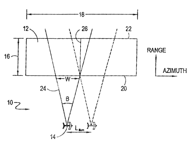
Referring to Fig. 1, a system 10 for producing a synthetic aperture
radar (SAR} mapping of a ground strip 12 is shown. As shown in Fig. 1, the
system 10 includes a moving platform 74 that is equipped with synthetic
aperture radar. A suitable SAR for the system 1(~ is the Lynx radar that has
been designed and built by Sandia National Laboratories in collaboration with
General Atomics. Although Fig. 1 illustrates the moving platform 14 as an
airplane, it is to be appreciated that the moving platform is not limited to
manned aircraft, but instead can include unmanned air vehicles (IJAV} or any
other moving platform capable of controlling the movement of at least a
portion of an SAR to include the antenna of the SAI~.
Vllith continued reference to Fig. 1, an exemplary, rectangular shaped,
ground strip 12 is shown having a size that !s defned by a range swath 16 in
the range direction (i.e. the direction normal to thE= direction of movement
of
the platform 14} and an overall 8ength 18 in the azimuthal direction (i.e. the
direction that is parallel with the direction of movement of the platform y4}.
As
further shown, the ground strip ~2 is bounded by a near-range edge 20 and a
far-range edge 22, with both edges 20, 22 extending substantially parallel to
the direction of movement of the platform 14.
5
CA 02453963 2003-12-22
APso shown in Fig. 1; a radar beam 24 projects from the platform 14
that subtends a substantially constant azimuthal beamwidth angle, ~.
The beamwidth angle is given approximately by:
'~ t
where l~ is the azimuthal dimension of the antenna.
At the near-range edge 20, the beam 24 maintains a substantially
constant azimuthal beamwidth, W, as the platform 14 moves parallel to the
near-range edge 20. it can further be seen from Fig. 1 that the beam 24
maintains the range line 26 illuminated while the plattorm 14 moves through a
distance L;""~,, and
'Grrr~ ~2~nsi~~~~=~
where f?m;~ is the distance between the platform '14 and the near-range edge
20.
Fig. 2 shows that a finite sized patch 28 can be continuously
illuminated while a radar platform 14 moves through a distance, L;",~", by
azimuthally sweeping the beam 24 relative to the platform 14 as the platform
14 moves. ~ompariso°~ of Figs. 1 and 2 shows that without sweeping
{i.e.
Fig. 1 ) only a range line 26 is ~ntinuausty ifiuminated during movement of
radar platform 14 through a distance, L;""",, white sweeping {i.e. Fig. 2j
a!(ows
a finite sized patch 28 to be continuously illuminated. In both cases, the
range line 26 or finite sized patch 28 is iifuminated ~nrhile the platform 14
moves through a distance, L;""~,, that is squat to the azimuthal beamwidth, W,
at the near-range edge 20.
Figs. 3A-F show that the ground strip 12 can be divided inte partions
30a-c, 32a-c, 34a-c that are sequentially mapped by the system 10. In
greater detail, the ground strip 12 is divided into r~~ctangs.~lar portions
30a-c,
32a-c, 34a-c that make up a tile-like pattern. The tile-like pattern can be
characterized as having columns 36, 38, 40, with each column 36, 38, 40
extending from the near-range edge 20 to the far-range edge 22. Although an
exemplary ground strip 12 divided into three columns 36, 38, 40 is shown, it
is
S
CA 02453963 2003-12-22
to be appreciated that the ground strip 12 can be divided into any number of
columns 36, 38, 40. Each column 36, 38, 40 has a column length in the
azimuthal direction that is equal to the beamwidth, W, at the near-range edge
20. Accordingly, each column 36, 38, 40 (and thc.rs each portion 30a-c, 32a-c,
34a-c) has a substantially equal length.
As shown in Fig. 3A, the exemplary ground strip 12 is divided into nine
portions 30a-c, 32a-c, 34a-o. Specifically, as shown, column 36 includes
three portions 30a-c, column 38 includes three portions 32a-c and column 40
includes three portions 34a-c. it can be seen from Fig. 3A that the width, w,
of
each portion 30a-c, 32a-c, 34a-c, measured in the range direction, is not
necessarily equal for all portions 30a-c, 32a-c, 34a-c. instead, as shaven,
the
width, w, of each portion 30a-c, 32a-c, 34a-c increases with increasing
distance (i.e. range) from the platform 14 because the depression angle, ~,
(shown in Fig. 4) has decreased. As detailed further below, the width, w, and
number of portions 30a-c, 32a-o, 34a-c in each column 36, 38, 40 will depend
on a number of factors including the elevation of the platform 14 above the
ground, the desired resolution and the depression angieU ~, at the far-range
edge 22.
Figs. 3A-F illustrate the sequential portion-by-portion mapping that
begins with a mapping of portion 30a, as seen in Fig. 3A. With combined
reference to Figs. 3A-F it can be seen that the ground strip 12 can be mapped
by sequentially mapping each column 36, 38, 40, and each column 36, 38, 40
can be mapped by sequentially mapping each portion 30a-c, 32a-c, 34a-c
within the respective column 36, 38, 40.
As the platform 14 moves, each column 36, 38, 40 along the ground
strip 12 is sequentially illuminated by the radar beam 24. With reference to
Figs. 3A-C, it can be seen that columrB 36 remains illuminated while the
platform 14 moves through a distance L;,iUm that is equal to the distance, W,
(i.e. the near range beamwidth). it can be further seen that the beam 24 is
azimuthaliy sweeped relative to the platform 14 see discussion above
regarding Fig. 2}. the sv~eep rate shown is continuous and uniform from a
first orientation solid line it7 Fig. 3A} to a secan c1 orientation (dotted
line in Fig.
7
CA 02453963 2003-12-22
3C) as the platform 14 moves through the distance t,;mm. The azimuths!
sweeping of the beam 24 allows the entire column 26 to remain illuminated as
the platform 14 moves through the distance t-;""m. Cross-referencing Figs. 3C
and 3D, it can be seen that once platform 14 reaches the end of column 36,
the beam 24 is rapidly reoriented from the second orientation to the first
orientation to allow column 38 to be illuminated as platform 14 movement
continues.
Continuing with reference to Figs. 3A-3C, it can be seen that portions
30a, 30b and 30c are mapped sequentially white column 36 is illuminated.
More specifically, portion 30a is mapped with an SAFE aperture length, I~,
corresponding to the distance the platform 14 ha:. moved in Fig. 3A (i.e. from
the first position where represented by solid lines to the second position
represented by dashed lines).
V~ith cross-reference to Figs. 3A, 313 and 4, it can be seen that once
the platform 14 has moved through the distance, 1~, the depression angle, ~,
___ of the radar beam 24 is reduced to map portion 30b. In greater detail, a
directing mechanism 42, such as a mechanics! ginabal or an actively scanned
phased array, can be used to rotate radar antenna 44 to thereby alter the
depression angle, ~, of the radar beam 24. At the new depression angle, ~,
the next portion, in this case portion 30b, is mapped with an SAR aperture
length, !2, corresponding to the distance the platform 14 has moved in Fig. 3B
(i.e. from the position where represented by solid lines to the position
represented by dashed lines). Refen-ing now with reference to Figs. 3l3 and
3C, once the platform 14 has moved thr ough the distance, i2, the depression
angle, ~, of the radar beam 24 is reduced to map portion 30c. At the reduced
depression angle, ~, portion 3C~c is mapped with an SAR aperture length, 13,
corresponding to the distance the platform 14 has moved in Fig. 3C (i.e. from
the position where represented by solid lines to the position represented by
dashed lines). The sum of aperture lengths, 9, for the column 36 are equal or
slightly less than the distance the platform 14 moves during illumination of
the
column 36 (i.e. !, ~- !2 ~ l3 s L;uun,), with some platform 14 movement
allotted to
altering the depression angle, ~, and reorienting the beam ?_4 back to the
first
8
CA 02453963 2003-12-22
sweep orientation. From Figs. 3A-3CN it can be seen that the aperture length,
I, is increased as the depression angle, ~, decreases to allow the portions
30a-c to be mapped with the same resolution (Ig < i2 < f3)., Specifically, for
a
given resolution, p, fhe length of the synthetic aperture is given by:
r~=a~'~
2p
where Rn"A is the far range of the portion 30a-c and aw is the azimuthal
windowing factor, which for Lynx, ~W ~'fi .2. Since R,~ increases wifh
decreasing depression angle, ~, it follows that tl'~te aperture length, 1,
must
increase with decreasing depression artgie, ~, to maintain resolution p.
At fine resolution, p can be so small that I ~ ~.~nUm. In this case, an
extended swath SAR stripmap cannot be made. At coarser resolutions, ! <
t-itlum. In these cases, one may take advantage of the smaller values of
"!° to
produce multiple tiles to extend the range swath.
Once the portions 30a-c in column 3f have been mapped, the beam 24
~ 5 is rapidly reoriented to the beam orientation indicated by the solid lines
!n Fig.
3D to prepare for the sequential mapping of portions 32a-c in column 38.
Vllith reference to Figs. 3~-3F, it can be seen that column 38 is mapped in a
manner similar to column 36 as described above. Il~ore specifically, portion
32a is mapped with an SAR aperture length, !4, corresponding to the distance
the platform 14 has moved in Fig. 3D (i.e. from the first position where
represented by solid tines to the secorvd position represented by dashed
lines). Once the platform 14 has moved through the distance, 14, the
depression angle, ~, of the radar beam 24 is reduced to map portion 32b. At
the reduced depression angle, ~, portion 32b is mapped with an SAR aperture
length, 15, corresponding to the distance the platform 14 has moved in Fig. 3E
(i.e. from the position where represented by solid lines to the position
represented by dashed lines).
~nce the platforrrt 34 has mo~,~ed through the distance, 15, the
depression angle, ~, of the radar beam 24 is once again reduced to map
portion 32c. At the reduced depression angle, ~, portion 32c is mapped with
g
CA 02453963 2003-12-22
an SAR aperture length, is, corresponding to the distance the platform 14 has
moved in Fig. 3F (i.e. from the position where represented by solid lines to
the
position represented by dashed iines~. The sum of aperture lengths, I, for the
column 38 are equal to or slightly less titan the distance the platform 14
moves during illumination of the column 38 (i.e. h ~- is + i~ <_ L;""mj. Once
column 38 has been crapped, remaining columns, such as column 40, can be
mapped in a similar manner. l~ufing the sequential mapping, portion maps
are stored in computer memory until all portions 30a-r, 32a-c, 34a-c have
been mapped. Once a!l portions 30a-c, 32a-c, 34a-c in the ground strip 12
have been SAR mapped, the stored maps are mosaicked, for example using
image processing softu~rare, to produce a single SAR reap of the ground strip
12.
The system 10 is capable of mapping a coverage area that is not
necessarily limited by the radar beam shape or the number of range pixels
used by the radar. The width (R",~X - R~,;~) of each portion 30a-c, 32a-c, 34a-
c
in the ground strip 12 is generally limited at large depression angles, ~, by
the
radar beam shape:
_mRa I 1
h sink -sin(+r~
anaenrsa
On the other hand, at small depression angles, ~, the width (Rmax -
R~,;~) of each portion 30a-c, 32a-c, 34a-c in the ground strip 12 is generally
limited by the number of range pixels used by the radar:
Npize(tp
P
where p is the resolution, lVpur,~ is the number of pixels and ~ is the rmmber
of pixels per resolution cell-
The number of range swaths that can be .søac~ed on one another
depends on how much time is available, which depends on ~;"~m:
1
T- = 1 2~"a Sic
V <1f.
CA 02453963 2003-12-22
where v is the aircraft velocity. Rm;n is the min(mum range of the exfended
swath.
Lur~m
The time required to mosaic t~ extended swaths is given by:
?~q = T,~ (I) ~" ~gimbed + Tolhe~ ~ ~up (~~ ~' Tgunbar ~ Torher + . . .. +
~"ap (~J') + ~~eQr ~ ~ then
where the aperture time of the I~th step is just:
~-op(N) = ~WA~"~(~3
2p~
and R""x (N) is the far range of the Nth tiled image.
To maxim(ze the tote( extended swath, the earn at the shallowest
depression angle desired is calculated since at small depression angles, the
range swath is maximum. Requiring that T~eQ s ~'Q"Q,.r determines N.
V~hi(e the particular System And Method For Syf~thetic Aperture radar
tvlapping A Ground Strip Having Extended Range Swath as herein shown and
d(sc(osed in detail are fully capable of obtaining the. objects and providing
the
~ 5 advantages herein before stated, it is to be unders t that they are merely
illustrative of the presently preferred embodiments of the invention and that
no
limitations are intended to the details of construction or design herein shown
other than as described in the appended claims.
t 'E