Note: Descriptions are shown in the official language in which they were submitted.
CA 02455810 2004-01-23
System for Information Extraction from Geologic Time Volumes
BACKGROUND OF THE INVENTION
=
1. Field of the Invention
This invention is related to seismic. data processing. More specifically, the
invention relates to a system for organizing seismic data.
2. Background
Geophysical and geologic study of the subsurface structure of the earth
continues to be an important field of endeavor for several reasons. The
continued
search for producing reservoirs of hydrocarbons, such as oil and gas, is a
particularly
important motivation for obtaining information about the earth's subsurface.
Conventional seismic surveying is generally performed by imparting energy to
the earth at one or more source locations, for example, by way of a controlled
explosion, mechanical impact or the like. Return energy is then measured at
surface
receiver locations at varying distances and azimuths from the source location.
The travel
time of energy from source to receiver, via reflections and refraction from
interfaces of
subsurface strata is indicative of the depth and orientation of the subsurface
strata.
The generation of instantaneous phase sections derived from seismic data is
referred to in an article by Taner and Sheriff included in AAPG Memoir 26 from
1977,
in which it is stated:
-"The instantaneous phase is a quantity independent of reflection strength.
Phase emphasizes the continuity of events; in phase displays. . . every peak,
every trough, every zero-crossing has been picked and assigned the same color
so that any phase angle can be followed from trace to trace." And "Such phase
displays are especially effective in showing pinchouts, angularities and the
interference of events with different dip attitudes."
-1-
CA 02455810 2010-12-14
Various phase unwrapping techniques are known, including those disclosed in
Ghiglia, Dennis C. and Pritt, Mark D., Two-Dimensional Phase Unwrapping
Theory,
Algorithms, and Software, John Wiley & Sons, Inc., New York, NY, 1998. Methods
of obtaining topography from synthetic aperture radar data have also used
phase
unwrapping techniques.
A long felt need continues to exist, however, for improved systems for
organizing, storing and displaying seismic information to assist in the
analysis and
interpretation of the subsurface structure and geology.
SUMMARY OF THE INVENTION
In a preferred embodiment the invention comprises a system for analyzing
seismic data which includes selecting a geologic time volume for a subsurface
region
of interest and selecting a procedure for generating a derived data volume
based on
the geologic time volume. The selected procedure is used to calculate the
derived data
volume and the derived data volume is stored in a data storage medium. In
specific
embodiments of the invention, the derived data volumes include but are not
limited to
difference volumes, discontinuity volumes, fault volumes, unconformity
volumes,
throw volumes, heave volumes, dip magnitude volumes, dip azimuth volumes,
strike
volumes, surface normal volumes, closure volumes, spill point volumes, isopach
volumes and isopach anomaly volumes.
In accordance with one aspect of the present invention, there is provided a
method for analyzing seismic data comprising selecting a geologic time volume
for a
subsurface region of interest, selecting a procedure for generating a derived
data
volume based on the geologic time volume, utilizing the selected procedure to
calculate the derived data volume, and storing the derived data volume on a
data
storage medium.
In accordance with another aspect of the present invention, there is provided
a
method for analyzing seismic data comprising selecting a geologic time volume
for a
subsurface region of interest, selecting a procedure for generating a
difference volume
-2-
CA 02455810 2010-12-14
4.
based on the geologic time volume, utilizing the selected procedure to
calculate the
difference volume, and storing the difference volume on a data storage medium.
In accordance with a further aspect of the present invention, there is
provided
a method for generating a difference volume based on a portion of a geologic
time
volume, comprising selecting a portion of a geologic time volume for a
subsurface
region of interest, selecting a method for calculating geologic time
differences
between data points in the geologic time volume, selecting a sign convention
for
representing the calculated geological time differences, select difference
values to be
calculated, calculating the selected difference values over the selected
portion of the
geologic time volume, and storing the calculated difference values on a data
storage
medium, thereby generating the difference volume.
In accordance with yet a further aspect of the present invention, there is
provided a method for analyzing seismic data comprising selecting a geologic
time
volume for a subsurface region of interest, selecting a procedure for
generating a
discontinuity volume based on the geologic time volume, utilizing the selected
procedure to calculate the discontinuity volume, and storing the discontinuity
volume
on a data storage medium.
In accordance with yet another aspect of the present invention, there is
provided a method for analyzing seismic data comprising selecting a geologic
time
volume for a subsurface region of interest, selecting a procedure for
generating an
unconformity volume based on the geologic time volume, utilizing the selected
procedure to calculate the unconformity volume, and storing the unconformity
volume
on a data storage medium.
In accordance with yet a further aspect of the present invention, there is
provided a method for analyzing seismic data comprising selecting a geologic
time
volume for a subsurface region of interest, selecting a procedure for
generating a fault
volume based on the geologic time volume, utilizing the selected procedure to
calculate the fault volume, and storing the fault volume on a data storage
medium.
-2a-
CA 02455810 2010-12-14
In accordance with yet another aspect of the present invention, there is
provided a method for analyzing seismic data comprising selecting a geologic
time
volume for a subsurface region of interest, calculating throw values and heave
values
within the geologic time volume in an in-line direction, calculating throw
values and
heave values within the geologic time volume in a cross line direction,
combining the
calculated throw and heave values to create in-line displacement vectors,
combining
the calculated throw and heave values to create cross line displacement
vectors,
forming vector cross products of the in-line displacement vectors and the
cross line
displacement vectors to generate surface normal vectors, and storing the
surface
normal vectors in a surface normal vector volume.
In accordance with yet a further aspect of the present invention, there is
ss
provided a method for analyzing seismic data comprising selecting a geologic
time
volume for a subsurface region of interest, calculating throw values and heave
values
within the geologic time volume in an in-line direction, calculating throw
values and
heave values within the geologic time volume in a cross line direction,
calculating
throw magnitude and throw azimuth values from the in-line throw and cross line
throw values, calculating heave magnitude and heave azimuth values from the in-
line
heave and cross line heave values, and storing the throw magnitude and throw
azimuth in a throw magnitude and azimuth volume and storing the heave
magnitude
and heave azimuth in a heave magnitude and azimuth volume.
In accordance with yet another aspect of the present invention, there is
provided a method for analyzing seismic data comprising selecting a geologic
time
volume for a subsurface region of interest, selecting a procedure for
generating a
throw volume based on the geologic time volume, utilizing the selected
procedure to
calculate the throw volume, and storing the throw volume on a data storage
medium.
In accordance with yet a further aspect of the present invention, there is
provided a method for analyzing seismic data comprising selecting a geologic
time
volume for a subsurface region of interest, selecting a procedure for
generating a
heave volume based on the geologic time volume, utilizing the selected
procedure to
calculate the heave volume, and storing the heave volume on a data storage
medium.
-2b-
CA 02455810 2010-12-14
In accordance with yet another aspect of the present invention, there is
provided a method for analyzing seismic data comprising selecting a geologic
time
volume for a subsurface region of interest, selecting a procedure for
generating a
throw volume and a heave volume based on the geologic time volume, utilizing
the
selected procedure to calculate the throw volume and the heave volume, and
storing
the throw volume and heave volume on a data storage medium.
In accordance with yet a further aspect of the present invention, there is
provided a method for analyzing seismic data comprising selecting a subsurface
region of interest, selecting a procedure for generating a dip volume based on
a
geologic time volume from the subsurface region of interest, utilizing the
selected
procedure to calculate the dip volume, and storing the dip volume on a data
storage
medium.
In accordance with yet another aspect of the present invention, there is
provided a method for analyzing seismic data comprising selecting a subsurface
region of interest, selecting a procedure for generating a strike volume based
on a
geologic time volume from the subsurface region of interest, utilizing the
selected
procedure to calculate the strike volume, and storing the strike volume on a
data
storage medium.
In accordance with yet a further aspect of the present invention, there is
provided a method for analyzing seismic data comprising selecting a geologic
time
volume for a subsurface region of interest, selecting a procedure for
generating a
closure volume based on the geologic time volume, utilizing the selected
procedure to
calculate the closure volume, and storing the closure volume on a data storage
medium.
In accordance with yet another aspect of the present invention, there is
provided a method for analyzing seismic data comprising selecting a geologic
time
volume for a subsurface region of interest, selecting a procedure for
generating a spill
point volume based on the geologic time volume, utilizing the selected
procedure to
calculate the spill point volume, and storing the spill point volume on a data
storage
medium.
-2c-
CA 02455810 2010-12-14
In accordance with yet a further aspect of the present invention, there is
= provided a method for analyzing seismic data comprising selecting a
geologic time
volume for a subsurface region of interest, selecting a procedure for
generating an
isopach volume based on the geologic time volume, utilizing the selected
procedure to
calculate the isopach volume, and storing the isopach volume on a data storage
medium.
In accordance with yet another aspect of the present invention, there is
provided a method for analyzing seismic data comprising selecting a geologic
time
volume for a subsurface region of interest, selecting a procedure for
generating an
isopach anomaly volume based on the geologic time volume, utilizing the
selected
procedure to calculate the isopach anomaly volume, and storing the isopach
anomaly
volume on a data storage medium.
In accordance with yet a further aspect of the present invention, there is
provided a method for generating an isopach anomaly volume for a subsurface
region
of interest, comprising selecting a portion of a geologic time volume for the
subsurface region of interest, successively selecting surfaces of constant
geologic time
from the portion of the geologic time volume obtaining isopach values for data
points
on the selected surfaces of constant geologic time, obtaining average isopach
values
for the surfaces of constant geologic time, comparing isopach values for the
data
points with the average values to determine isopach anomaly values for the
data
points, and storing the isopach anomaly values in an isopach anomaly volume.
In accordance with yet another aspect of the present invention, there is
provided a digital computer programmed to perform a process comprising the
steps of
selecting a geologic time volume for a subsurface region of interest,
selecting a
procedure for generating a derived data volume based on the geologic time
volume,
utilizing the selected procedure to calculate the derived data volume, and
storing the
derived data volume on a data storage medium.
In accordance with yet a further aspect of the present invention, there is
provided a device which is readable by a digital computer having instructions
defining
the following process and instructions to the computer to perform the process
-2d-
CA 02455810 2010-12-14
selecting a geologic time volume for a subsurface region of interest,
selecting a
procedure for generating a derived data volume based on the geologic time
volume,
utilizing the selected procedure to calculate the derived data volume, and
storing the
derived data volume on a data storage medium.
BRIEF DESCRIPTION OF THE DRAWINGS
FIG. I shows a representative seismic data section.
FIG. 2 shows a computer system useful for practicing the invention.
-2e-
CA 02455810 2004-01-23
FIG. 3 is a flow diagram illustrating a process for performing various
embodiments of the invention.
FIG. 4A is a flow diagram showing a process that may be performed to generate
a difference volume.
FIG. 4B is a flow diagram showing a process that may be performed to generate
a discontinuity volume.
FIG. 5 is a flow diagram which outlines a process for generating a fault
volume
FIG. 6 is a flow diagram which outlines the process for generating an
unconformity volume.
FIG. 7 is a flow diagram which outlines a process for generating heave and
throw volumes.
FIGS. 8A and 8B provide an illustration of an application of the invention for
generating heave and throw volumes.
FIG. 9 is a flow diagram which outlines a process for generating a dip
volumes.
FIG. 10 is a flow diagram which outlines a process for generating a closure
volume.
FIG. 11 is a flow diagram which outlines a process for generating an isopach
volume.
FIG. 12 is a flow diagram which outlines a process for generating an isopach
anomaly volume.
DESCRIPTION OF THE PREFERRED EMBODIMENT
FIG. 1 shows a representative seismic data section. For clarity, a two
dimensional seismic data section is shown, although the invention described
herein is
applicable to three dimensional (3D) seismic data as well as to two
dimensional (2D)
seismic data, and the invention will be described herein primarily with
reference to a 3D
seismic data volume. Although the seismic data traces shown in FIG. 1 are
shown as
continuously sampled in the travel time direction, those of ordinary skill in
the art will
-3-
CA 02455810 2010-12-14
recognize that each seismic data trace is recorded by sampling the reflected
seismic
energy at discrete sample times at intervals typically ranging from 1 to 4
milliseconds.
Although the following text generally describes the procedure in relationship
to data in
two way travel time, the procedures described herein are equally valid for
seismic data
which have been converted to depth.
U.S. Patent No. 6,850,845 discloses methods for generating geologic time
volumes. U.S. Patent No. 6,708,118 discloses methods for utilizing geologic
time
volumes. In a geologic time volume, geologic time values are stored in memory
locations on a data storage medium. These geologic time values are estimates
of the
geologic time at which sediments were deposited. The goal of generating a
geologic
time volume is to have a representation of geologic time for corresponding
sample
points in a seismic data volume. The geologic time volume data are normally
stored on
a computer storage medium, such as a magnetic or optical disk, magnetic tape,
computer random access memory, or other storage media which may be read by a
computer.
Typically, in generating a geologic time volume from a seismic data volume,
the
geologic time volume will have the same spatial dimensions as the seismic data
volume.
Each x, y and z data point in the seismic data volume (where x and y represent
the in-
line and cross line directions, and z represents the travel time or depth)
will have a
corresponding point in the geologic time volume. The seismic data volume might
typically include 2000 cross lines and 2000 in-lines and extend for a depth of
greater
than 3000 time samples, for a total of 12,000,000,000 (12 x 109) data sample
points.
The difference between the geologic time volume and the seismic data volume is
that the
value of the data point in the geologic time volume will be related to
geologic time (or
pseudo geologic time), rather than reflection amplitude (or other measured or
calculated
seismic attribute value).
-4-
CA 02455810 2004-01-23
Although a geologic time volume will typically be coextensive in space with a
seismic data volume from which the geologic time volume was developed, data
compression techniques may have been used in generating the geologic time
volume,
and uncompression techniques may be required to regenerate data points from a
geologic time volume which correspond to data points in the seismic data
volume.
In accordance with the present invention, a derived data volume is generated,
directly or indirectly, from a geologic time volume. These derived data
volumes include,
but are not limited to, difference volumes, discontinuity volumes, fault
volumes,
unconformity volumes, throw volumes, heave volumes, dip magnitude volumes, dip
azimuth volumes, strike volumes, surface normal volumes, closure volumes,
point spill
volumes, isopach volumes and isopach anomaly volumes. These derived data
volumes
may provide a better understanding of the geologic history as well as provide
new
insights into the potential locations of hydrocarbons.
= The process of the invention disclosed herein is most conveniently
carried out by
writing a computer program (or programs) to carry out the steps described
herein on a
work station or other conventional digital computer system of a type normally
used in
the industry. Data from (or based on) a geologic time volume are retrieved,
and other
operations performed by a suitable computer system, such as a personal
computer or
UNIX workstation. The generation of such a program may be performed by those
of
ordinary skill in the art based on the processes described herein. FIG. 2
shows such a
conventional computer system 12 comprising a central processing unit 14, a
display
(monitor) 16, peripheral devices 13 (such as disk drives) and an input device
15 (such as
a keyboard and mouse). The computer program for carrying out the invention
will
normally reside on a storage medium (not shown) associated with the central
processing
unit. Such computer program may be transported on a CD-ROM, a magnetic tape or
magnetic disk, an optical disk, or other storage media, shown symbolically as
storage
medium 18.
-5-
CA 02455810 2004-01-23
Generally, seismic data are gathered by advancing a seismic source along a
substantially straight line, and detecting the resulting seismic signals with
sensors
arranged in a rectangular grid, either on land or on cables pulled behind a
vessel or laid
on the sea floor. The direction in which the source advances is typically
referred to as
the "in-line" direction. The "cross line" direction is perpendicular to the in-
line
direction. The terms "in-line" and "cross line" are also generally used for
specifying
directions within the recorded seismic data corresponding to the recording
pattern, and
many of the calculations described herein are calculated between data points
in a
geologic time volume (or a data volume derived from a geologic time volume)
positioned along lines extending through the volume in either the in line or
cross line
direction. However, the processes described herein are not limited to the
directions
typically referred to as in-line and cross line, but may be calculated along
directions that
are rotated with respect to the directions typically referred to as in-line
and cross line.
Accordingly, the term "in-line" as used hereinafter may refer to any selected
direction,
or displacement, extending substantially horizontally through a geologic time
volume (or
a data volume derived from a geologic time volume), and the corresponding
"cross line"
direction will be the direction perpendicular to the in line direction and
extending
substantially horizontally through the geologic time volume (or a data volume
derived
from a geologic time volume).
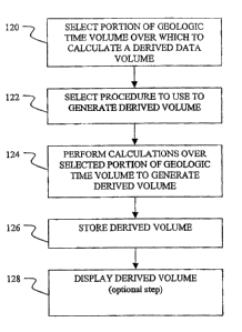
In accordance with the present invention, FIG. 3 is a flow diagram
illustrating
the steps which may be performed in implementing the invention in its various
embodiments to generate the derived data volumes. In step 120 a portion of a
geologic
time volume is selected over which one or more derived data volumes will be
generated.
This portion could be the entire data volume, or could be limited, for
example, by an in-
line range, a cross line range, a travel time range, a depth range, a geologic
time range,
or any combination of the above. Next, in step 122, a procedure is selected
which will
be used to generate the derived data volume (or volumes). Such procedures
include but
are not limited to procedures further discussed herein. Some of the procedures
can
utilize previously generated derived volumes. As part of the procedure
selection, the
-6-
CA 02455810 2004-01-23
user can determine if the user desires to utilize previously generated derived
data
volumes to generate new derived data volumes, or use the geologic time volume
and
procedures that temporarily generate the derived data values that need to be
utilized for
generating the new derived data volumes. In step 124 the necessary
calculations are
performed using procedures selected in step 122 over the portion of the
geologic time
volume selected in step 120. In step 126 the derived data volume that results
from step
124 is stored on a suitable storage device. This might be in computer random
access
memory (RAM) or on a magnetic disk or other computer storage device known to
those
skilled in the art. The resultant derived data volume may optionally be
displayed in step
128 using data display and visualization methods known to those skilled in the
art.
Visualization programs contain the ability to modify color values (which
include gray
scale values), and opacity values to identify anomalous data points. VoxelGeo,
a
volume visualization software product marketed by Paradigm Geophysical (a
company
having an office in Houston, Texas), is one such example of a well-known
volume
visualization package used in the petroleum industry,
Difference Volumes
A geologic time volume will normally comprise a plurality of data sample
points
extending horizontally in the in-line and cross line directions, and also
extending
vertically in the time direction. For purposes of the following discussion,
these data
sample points will be assumed to be consecutively numbered in the in-line,
cross line and
time directions. A geologic time change, also referred to herein as a
"difference value",
may be calculated from a geologic time volume. These difference values may be
calculated by taking the difference in geologic time of data sample points
(which may
also be referred to as data locations) in the geologic time volume. For
example, this
difference could be taken along either the in-line, the cross line, or the
time direction.
These differences could be calculated as either a forward difference, a
backward
difference or a gapped difference. By forward difference is meant the
difference
between a first data sample point and the next higher numbered data sample
point. By
backward difference is meant the difference between a first data sample point
and the
-7-
CA 02455810 2004-01-23
next lowest numbered data sample point. By gapped difference is meant the
difference
between data sample points which are not adjacent (for example, for a
particular data
location, gapped difference may be the difference between the geologic time of
a lower
numbered data sample point and a higher numbered data sample point than the
particular
data sample point). Whether to use forward difference, backward difference or
a
gapped difference for the calculations for a particular geologic time volume
is subject to
the judgment of the interpreter or analyst. The difference values could also
be
calculated at any angle to an in-line or cross line direction, or the time
direction. For
example, they could be calculated along the diagonal between the in-line and
cross line
axes by either incrementing or de,crementing both in-line and cross line
sample locations,
or by incrementing either the in-line or cross line sample location, and
decrementing the
other. In addition, the difference could be a combination of any of the
calculated
differences.
Geologic time changes calculated in the in-line direction may be referred to
herein as the "A inThre "difference values. Geologic time changes calculated
in the
cross line direction may referred to herein as the "A ,crossline" difference
values, and
geologic time changes in the time direction may be referred to as the "A time"
difference values.
The sign (positive or negative) of the resulting difference value will depend
upon
the convention used in the calculation (that is, whether a negative or
positive number is
used to indicate a decrease in geologic time) and the geology. In general it
is preferable
that a positive difference should indicate an increase in geologic time (a
change from a
younger to an older geologic time) between the two samples while a negative
number
will indicate a decrease in geologic time (a change from an older to a younger
geologic
time).
Other difference values may be calculated from A inline , A crossline and
A time difference values. Difference volumes may then be generated for any or
all of
-8-
CA 02455810 2004-01-23
the A inline, A crossline and A time difference values as well as for any of
the
other calculated difference values.
Further, the A inline, A crossline and A time difference values may be
deemed to be the difference values along three orthogonal axes through the
data
volume. Similar results may be obtained regardless of whether the data volume
is
rotated through an angle, or the axes from which the differences are calculate
are
rotated through an angle within the volume. For example, the A inline and
A crossline values could be generated along the diagonals of the in-line and
cross line
axes, rather than along the in-line and cross line axes. Therefore, it is
understood that
the A inline, A crossline and A time difference values referred to herein may
be
generated following the rotation of either the data volume or the axes along
which these
values are calculated.
The A inline, A crossline and A time difference values can be thought of as
defining points in a rectangular coordinate system. Therefore, these points
can be
converted to (or generated in) other coordinate systems, such as polar or
cylindrical,
thus generating other difference values. Six of the more useful difference
values which
may be calculated from the A inline, A crossline and A time difference values
are
as follows:
Total difference magnitude =
y
(A time- + A inline- + A crossline-7 ) 2 (Eq. 1)
y
Spatial difference magnitude = (A inline2 + A crossline2 ) 2 (Eq.
2)
In-line temporal difference magnitude = (A time2 + A inline2)Y2 (Eq- 3)
Cross line temporal difference magnitude =
-9-
CA 02455810 2004-01-23
(A time- + A crossline2 )%
(Eq. 4)
Azimuth of the total difference magnitude =
A crossline
inverse tangent of(Eq. 5)
A inline
Inclination (dip) of the total difference magnitude
= inverse cosine of A time /total difference magnitude (Eq. 6)
The spatial difference magnitude represents the difference value in the
horizontal plane.
In-line temporal difference magnitude represents the difference value within a
vertical
plane extending in the in-line direction (Eq. 3), and cross line temporal
difference
represents the difference value within a vertical plane extending in the cross
line
direction (Eq. 4).
Another manner in which the difference values can be represented is as
vectors,
the cross product of which will approximate a surface normal of a plane of
constant
geologic time. For instance, for A inline and A crossline values, the vectors
might be
in the form of in-line, cross line and geologic time difference. The A Milne
difference
value could be represented as (0, xL, A inline), where the first value is zero
since both
points are on the same in-line, xL is the number of traces (or distance)
between the two
points used to generate the A inline values, and A inline is a representative
of the in-
line vertical displacement. Similarly, the A crossline difference value could
be
represented as (iL, 0, A crossline), where iL is the number of traces (or
distance)
between the two points used to generate the A crossline value, the middle
value is
zero since both points are on the same cross line, and A crossline is a
representation of
the cross line vertical displacement. Similar vectors could be constructed for
other
difference values.
-10-
CA 02455810 2004-01-23
If a geologic time volume is contaminated with random noise, it may be
advantageous to perform some type of signal enhancement techniques to improve
the
detectablity of anomalous discontinuity locations. Such signal enhancement
techniques
are well known to those of ordinary skill in the art and include, but are not
limited to,
averaging the calculated differences over several data sample points,
performing some
type of least squares estimate (or other data fitting measure) based on the
calculated
values, or taking the maximum value found within a several data sample point
region.
Such signal enhancement techniques could be applied to the input geologic time
values,
or the calculated difference values.
FIG. 4A is a flow diagram illustrating the process that may be performed to
generate a difference volume. First, in step 20, the portion of the geologic
time volume
over which the difference values are to be calculated is selected. The
selected portion
may include the entire volume, or a smaller region of interest. Next, in step
22, the
method of calculating the differences is selected. For example, the forward
difference
method previously discussed might be selected. In step 24 a sign convention
for
representing the differences is selected. As stated previously it is normally
desired for an
increase in geologic time to be represented as a positive number. In step 26
one or more
values that are to be calculated are selected. These values may include, but
are not
limited to the A inline , A cross line and A time difference values, the total
difference
magnitude (Eq. I), spatial difference magnitude (Eq. 2), in-line temporal
difference
magnitude (Eq. 3), cross line temporal difference magnitude (Eq. 4), azimuth
of the total
difference magnitude (Eq. 5) and dip of the total difference magnitude (Eq.
6). It is
understood that steps 20, 22,24, and 26 can be performed in any order. In step
28, the
choices made in steps 20, 22,24, and 26 are used to calculate the selected
difference
values over the selected portion of the geologic time volume to generate the
selected
difference volume or volumes.
In step 30, the difference values calculated in step 28 are stored in a data
storage
medium to generate one or more difference volumes.
-11-
CA 02455810 2004-01-23
The resulting difference volumes can be displayed, in step 32, in any method
normally used to display seismic data (or seismic data attribute) volumes. In
particular,
volume visualization is a good way to display the resulting data volumes. With
volume
visiialization techniques, an opacity function can be used to show locations
of
anomalous difference values. For example, the VoxelGeo program marketed by
Paradigm Geophysical, referred to previously, may be used to make most of the
data
points transparent, while leaving the largest amplitude differences opaque.
It is understood that the difference values may be calculated from a derived
volume which has been derived from a geologic time volume, such as dip
magnitude, dip
azimuth or isopach volume, as well as directly from the geologic time volume.
The difference volumes described herein are useful for providing indications
of
discontinuity locations. However, being able to identify the anomalous
difference
locations, particularly those anomalous locations that are spatially
connected, will
provide improved information regarding the discontinuities.
Discontinuity Volumes
A discontinuity location is indicated by an anomalous change in geologic time
between two data sample points. The term "discontinuity value" as used herein
will
generally refer to an anomalous difference value, and will typically be
generated by
subtracting an average difference value from a difference value as further
described
herein. (Note: a discontinuity location might also be indicated by an
anomalous change
in other seismic data attributes.) Typically the data sample points over which
the
geologic time change is measured are adjacent; either vertically,
horizontally, or
diagonally. But this is not always the case as further described herein. An
"anomalous"
change in geologic time is normally thought of as a "large" change in geologic
time.
Typically, "large" might be a value that is more than one standard deviation
above the
local mean of the calculated geologic time changes. = A change in polarity
might also be
considered anomalous. Whether or not a time change is "anomalous" may be
-12-
CA 02455810 2004-01-23
subjectively determined based on the data in a particular volume and the
manner in
which the geologic time changes are calculated. For example, in areas of
moderate dip a
small reverse fault could juxtapose beds of similar age, thus producing a
small geologic
time difference in a region that typically has higher geologic time
differences. In this
case, a small geologic time difference would indicate a discontinuity.
Therefore, in one
implementation of the invention, geologic time changes are calculated, and
these
changes are then studied (or further processed) to identify the anomalous
locations. For
example, a measure could be obtained of how a particular difference value
deviates from
an average difference value.
The primary causes of discontinuities in seismic data, and therefore in a
geologic
time volume, are unconformities, faults, fluid contacts, source generated
noise (such as
multiples, sideswipe, and converted waves), and noise from unknown causes.
Discontinuity volumes may be generated which depict all discontinuities,
however
caused. However, as further described herein, discontinuity volumes may also
be
generated which display specific types of discontinuities, such as faults,
unconfonnities
or discontinuities from unknown (or unassigned) causes. Note that locations
identified
by discontinuities from unknown causes might indicate locations where there
are
problems in the geologic time volume. If this is the case, typically locations
close to
these discontinuities will have geologic time values that do not directly
correspond to
the geologic time at which the sediments corresponding to the data sample
points were
deposited. Such locations identified by discontinuities from unknown causes
may
indicate potential interpretation errors, or geologic time volume generation
errors.
FIG. 4B is a flow diagram illustrating the process that may be performed to
generate a discontinuity volume. In step 33, the portion of the volume (or
volumes) to
be used in the discontinuity identification process is selected. This
selection process
includes selecting which type of volume to use. A geologic time volume (or a
portion of
such volume) may be selected, and various derived volumes may be generated
from the
geologic time volume, and then he utilized to generate a discontinuity volume.
A
-13-
CA 02455810 2004-01-23
derived data volume previously derived from a geologic time volume may also be
= selected for generating the discontinuity volume. Any of the difference
volumes just
described can be used in the process for generating a discontinuity volume.
Any of the
other derived volumes further described herein may also be used, such as a dip
magnitude, dip azimuth or isopach volume, but might not produce results as
good as the
results from use of the difference volumes.
In step 34, a method of identifying the anomalous points is selected. The term
"anomaly" and "anomalous" are used extensively in the geophysical literature.
Sheriff's
geophysical dictionary "Encyclopedic Dictionary of Exploration Geophysics, 2'
Edition", compiled by R. E. Sheriff, 1984, Society of Exploration
geophysicists includes
seven definitions, of which the first two are most applicable:
1. a deviation from uniformity in physical properties, a perturbation from
a
normal, uniform or predictable field, and
2. Observed minus theoretical value.
In addition, as used herein, an anomalous value also includes any value that
is a
perturbation from a normal, a uniform, or a predictable value based on its
neighboring
values (neighboring values may include anything from one point close to the
value to all
points in the volume). A predictable value includes, but is not limited to: a
global
average, a local average, a weighted average, a median value, a mode value, or
a curve,
surface, or volume fit to the neighboring values. An anomalous value can also
mean a
value that has a different appearance from the values that generally surround
it. Any of
these methods may be used fmd the anomaly or several of them may be used, and
the
anomalies detected by each method may be combined to generate a fmal output
anomaly
value. Perturbations based on a local average of the data volume is a simple
method to
implement that may detect most of the anomalous values. In the selection
process, a
threshold might be used to select only the larger perturbations. For example,
only those
perturbations that are one standard deviation or more away from the predicted
value
might be declared anomalous. The selection process might also include the
identification of local maximums, local minimums, or those locations where the
local
-14-.
CA 02455810 2004-01-23
difference values are more than some magnitude away from a local average
value. This
particular magnitude might be user selected, or it might be derived from the
data (a
stAndard deviation for example).
The selection criteria may also include connectivity tests. For example, it
may be
decided to only retain anomalous points that are connected to at least ten (or
some other
number of) other anomalous points.
In step 35, a method of representing the anomalous points is selected. Again,
there are several ways in which the anomalous points might be represented. In
general
there will be a representation that identifies a point as not being anomalous,
and another
representation that identifies a point as anomalous. One way of doing this is
to
represent the anomalous points with a single bit, which, for example, is "off"
if the point
is not considered anomalous or "on" if it is considered anomalous. The
anomalous
points might also be represented by a value that is a measure of the magnitude
of the
perturbation from a predictable value. The number of other anomalous points
that an
anomalous point is connected to is yet another way in which an anomaly might
be
represented.
hi. step 36, the portion of the volume selected in step 33 is searched to
identify
the anomalous points. These identified anomalous points are then stored, in
step 37, in a
discontinuity volume in the manner selected in step 35. If more than one
method of
representing the anomalous points is selected, then several discontinuity
volumes may be
generated. In step 38, the discontinuity volume or volumes can optionally be
displayed.
A volume visualization program, such as VoxelGeo is useful for displaying and
studying
such volumes to understand the geologic meaning of the detected discontinuity
locations. Opacity filtering will be particularly useful to display just the
locations that
have been selected as discontinuities. Such volume visualization programs
generally
contain voxel tracking procedures that can be used to identify regions of
connected
discontinuities.
-15-
CA 02455810 2004-01-23
It may also be useful to generate discontinuity volumes which display specific
types of discontinuities. Once a discontinuity has been identified in a
discontinuity
volume, attributes of the discontinuity (including but not limited to
magnitude of
deviation from mean) and the extent of the discontinuity may be used to
estimate the
cause of the discontinuity. Discontinuities that are spatially continuous and
predominantly horizontal are generally classified as unconfonnities.
Discontinuities
which are spatially continuous and substantially vertical are typically
faults.
Discontinuities which are predominantly horizontal and have a limited spatial
extent may
be indicative of a contact zone between different fluids (e. g., a gas-water,
oil-water, or
gas-oil contact surface). Some faults and unconformities will be apparent by
inspection
of opacity filtered discontinuity volumes because the faults and
unconformities will show
up as highly anomalous discontinuity values that are spatially continuous.
Because of
their limited spatial extent, fluid contact locations may be more difficult to
identify than
faults and unconformities, but may also be discernable.
Anomalies identified from the different input volumes, and from the various
difference calculations, may also be combined to form another volume of
discontinuity
locations.
Fault Volume
FIG. 5 outlines the process for generating a fault volume from a derived data
volume. Normally the volume to be used will be a discontinuity volume, such as
one of
those described above, or other volumes, such as those described below (e.g.,
the dip
magnitude and dip azimuth volumes, or the isopach volume). In step 40, the
volume or
volumes to be used in the fault identification process is selected. As part of
the selection
process, a portion of a volume may be selected (such as in the manner
described above)
instead of an entire derived volume. In step 41 the selected volume is
analyzed for the
presence of faults, and the fault locations are identified and extracted.
Connected areas
of anomalous spatial difference magnitude within the volume should be
indicative of
faults.
-16-
CA 02455810 2004-01-23
Of the volumes that might be selected in step 40, the discontinuity volume
derived from the spatial difference magnitude volume (calculated with Eq. 2)
is one of
the more useful discontinuity volumes for detecting faults, although other
discontinuity
volumes may be utilized. A spatial difference magnitude volume may also be
utilized in
conjunction with a dip magnitude volume, as described hereinafter, for
identifying fault
locations. Locations having both an anomalous spatial difference magnitude in
the
spatial difference magnitude volume and an anomalous value of inclination in
the dip
magnitude volume should be indicative of faults. Yet another method for
identifying
fault locations utilizes a spatial difference magnitude volume, a dip
magnitude volume
and a dip azimuth volume. The inclination, the azimuth, and the magnitude of
geologic
time change of identified fault points can be used to determine if there are a
plurality of
faults. Further, the azimuth, and the dip and difference magnitudes of an
identified fault
point can be used to determine which fault plane the identified fault point is
on, since on
any given fault plane, each of these values should vary slowly, but there
should be
significant variations in the combination of these values between different
fault planes.
An isopach volume (described further herein) may also be used to assist in
identifying fault locations. Abrupt lateral changes in the isopach values,
particularly
those that have linear trends in map view, can indicate the locations of
faults. This is
particularly true in areas of growth faulting, where the beds are generally
thicker on the
down thrown side of the faults. The abrupt lateral changes can be detected by
using the
isopach volume (in place of the geologic time volume) as input to the
difference volume
calculation, (particularly the spatial difference calculation), followed by
the discontinuity
volume calculation.
Fault identification processes (step 41 of FIG. 5), also referred to as the
fault
extraction processes, include but are not limited to the following methods.
One method
relies on visual identification of the faults by using data visualization
techniques such as
different color maps, or volume visualization with opacity filtering. In this
method,
-17-
CA 02455810 2004-01-23
unique colors or opacity values are assigned to the anomalous values. For
example,
data points having anomalous values could be assigned a red color, and other
data
points could be assigned a blue color. With regards to opacity, data points
having an
anomalous value could be assigned an opaque opacity value, and other data
points could
be assigned a transparent opacity value. A second method utilizes user
interaction
techniques to identify the actual fault points in addition to visual
identification
techniques. These user interaction techniques may include manually digitizing
anomalous points to distinguish between points that are geologically
significant and
those that are not, using polygons or polyhedrons to isolate anomalous opacity
regions,
and seed or voxel tracking techniques. A third method comprises numerical
filtering, of
which the opacity filtering could be considered one example, to isolate or
distinguish the
fault data points from the non-fault data points. This third method may
include dip
filtering, combining different attribute values and joint amplitude threshold
or filtering.
Some type of automated fault extraction technique, such as voxel tracking or
other
discontinuity tracking can then be applied to these enhanced data volumes to
extract the
actual fault locations.
In step 42 the identified fault locations are then utilized in generating a
fault
volume. In the fault volume, data points will represent some aspect of a
fault. The
aspect represented could be, for example, the existence or nonexistence of the
fault at a
particular location, or some other value representing the fault, such as the
geologic time
difference across the fault, or other anomalous value used to identify the
fault. The size
of the anomaly can be used as a measure of as how "good" the fault pick is.
The larger
the anomaly, the better the fault pick. In the case where the fault locations
are visually
identified, a color map, opacity function, or both are used to create a volume
in the
computer display memory that emphasizes the data locations that represent
faults and
de-emphasizes the non-fault locations. Normally these created volumes remain
in the
computer memory or display hardware. Although they can be saved to a permanent
storage medium, they are normally recreated when needed, by storing the color
table
and opacity functions used to generate the display. Such storage is viewed to
be in the
-18-
CA 02455810 2004-01-23
scope of step 42 of FIG. 5. A color map, opacity function, or both may also be
used to
provide a means of locating the "good" fault locations. For a color map, this
may be
accomplished, for example, by using a color scale that grades from white to
blue. The
lowest anomaly values are assigned the white colors and the highest anomaly
values are
assigned the blue colors, with the values between these endpoints being
assigned a
proportional color. If an opacity function is utilized, opacity can be used as
a measure
of how "good" the fault is. This is accomplished, for example, by using an
opacity scale
that grades from completely transparent to completely opaque. The lowest
anomaly
values are assigned the completely transparent values and the highest anomaly
values are
assigned the completely opaque values, with the values between these endpoints
being
assigned a proportional opacity. In such a display the opacity can be used as
a measure
of how "good" the fault is.
Optionally, in step 44, the locations included in the fault may also be
represented
in a typical interpretation database, in the form of data points, line
segments, poly-lines
or triangulated surfaces. These representations may be derived directly from
the
identified and extracted fault locations of step 41 or from the extracted
fault volumes of
step 42.
Step 46 is another optional step that can be performed. Once a particular data
point is determined to be part of a fault, it can be removed from the volumes
being used .
for differentiating between the different discontinuity iypes. A data point
removed may
be replaced with the average discontinuity value, or a special fault value,
and identified
so that it has a minimal affect on other calculations or discontinuity
differentiation
processes.
The resulting fault volume or extracted locations can be displayed, in step
48, in
any method normally used to display seismic data or seismic data attribute
volumes, or
fault locations obtained from conventional methods. In particular, volume
visualization
is a good way to display the derived resulting data volumes. With volume
visualization
-19-
CA 02455810 2004-01-23
techniques, an opacity function can be used to show just those locations
associated with
faults, and also the quality of the fault locations if they have been
represented in that
way.
Unconformity Volumes
In another implementation of the invention, unconformity volumes are
generated.
The methods for generating unconformity volumes are very similar to those used
to find
the faults, except that unconformities are substantially horizontal. If fault
locations are
identified and removed from the data used to find the unconformities (or vise
versa
depending on which are found first), the process may be potentially speeded
up. With
reference to FIG. 6, in step 50, a volume or volumes are selected to be used
in the
unconformity identification process. These volumes are analyzed, in step 51,
for the
presence of unconformities. In searching for unconformities the discontinuity
volume
derived from the time difference volume ( A time volume), which includes
geologic time
changes in the time direction, may be the most useful, since unconformities
will appear
as approximately horizontal, spatially continuous discontinuities. A time
difference
volume ( A time volume) generated from an isopach volume, instead of directly
from a
geologic time volume, as input for the calculation of a discontinuity volume
might also
be useful for locating the unconformities.
The unconformity extraction processes, step 51, may be substantially similar
to
the fault extraction processes described above with reference to step 41.
Unconformity
extraction processes include but are not limited to the following methods. One
method
relies on visual identification of the unconformities by using data
visualization techniques
such as different color maps, or volume visualization with opacity filtering.
A second
method utilizes user interaction techniques to identify the unconformity
points in
addition to visual identification techniques. These user interaction
techniques may
include manually digitizing anomalous points to distinguish between points
that are
geologically significant and those that are not, using polygons or polyhedrons
to isolate
anomalous opacity regions, and seed or voxel tracking techniques. A third
method
CA 02455810 2004-01-23
comprises numerical filtering, of which the opacity filtering could be
considered one
example, to isolate or distinguish the unconformity data points from the non-
unconformity data points. This third method may include dip filtering,
combining
different attribute values and joint amplitude threshold or filtering. Some
type of
automated unconformity extraction technique, such as voxel tracking or other
discontinuity tracking can then be applied to these enhanced data volumes to
extract the
actual unconformity locations.
An unconformity volume is created in step 52 in which data points in the
unconformity volume represent some aspect of the unconformity. The aspect
represented could be, for example, the existence or nonexistence of the
unconformity at
a particular location, the amount of geologic time missing across the
unconformity, or
some other value representing the unconformity. The size of the anomaly value,
the
number of other anomalous points the anomaly is connected to, or any
combination of
these measurements can be used as a measure of how "good" the unconformity
pick is.
In the case where the unconformity locations are visually identified, a color
map, opacity
function, or both are used to create a volume in the computer display memory
that
emphasizes the data locations that represent unconformities and de-emphasizes
the non-
unconfomiities locations. Normally these created volumes remain in the
computer
memory or display hardware. Although they can be saved to a permanent storage
medium, they are normally recreated when needed, by storing the color table
and
opacity functions used to generate the display. Such storage is viewed to be
in the
scope of step 52 of FIG. 6. A color map, opacity function, or both may also be
used to
provide a means of locating the "good" unconformity locations. For a color
map, this is
accomplished, for example, by using a color scale that grades from white to
blue. The
lowest anomaly values are assigned the white colors and the highest anomaly
values are
assigned the blue colors, with the values between these endpoints being
assigned a
proportional color. If an opacity function is utilized, the opacity can be
used as a
measure of how "good" the unconformity is. This is accomplished, for example,
by
using an opacity scale that grades from completely transparent to completely
opaque.
-21-
CA 02455810 2004-01-23
The lowest anomaly values are assigned the completely transparent values and
the
highest anomaly values are aRsigned the completely opaque values, with the
values
between these endpoints being assigned a proportional opacity. In such a
display the
opacity can be used as a measure of how "good" the unconformity is.
Optionally, in step 54, the locations included in the unconformity may also be
represented in a typical interpretation data base, in the form of data points,
line
segments, poly-lines or triangulated surfaces. These representations may be
derived
directly from the identified and extracted unconformity locations of step 51
or from the
extracted unconformity volumes of step 52.
Step 56 is another optional step that can be performed. Once a particular data
point is determined to be part of an unconformity, it can be removed from the
volumes
being used for differentiating between the different discontinuity types. A
data point
removed may be replaced with the average discontinuity value, or a special
unconformity value, and identified so that it has a minimal affect on other
calculations or
discontinuity differentiation processes.
The resulting unconformity volume or extracted locations can be displayed, in
step 58, in any method normally used to display seismic data, seismic data
attribute
volumes, or unconformity locations obtained from conventional methods. In
particular,
volume visualization is a good way to display the resulting derived data
volumes. With
volume visualization techniques, an opacity function can be used to show just
those
locations associated with unconformity, and also the quality of the
unconformity
locations if they have been represented in that way.
An unconformity volume may also include fluid contact surfaces. The dips of
horizons above and below a discontinuity provide a further indication as to
whether a
particular discontinuity represents an unconformity or a fluid contact
location. If the
horizons above and below the discontinuity are substantially continuous across
the
CA 02455810 2004-01-23
discontinuity (almost as if the discontinuity was not there), the
discontinuity is typically a
fluid contact location. If the horizons above and below the discontinuity
exhibit
substantially different strike and/or dip across the discontinuity, the
discontinuity is
typically an unconformity. A fluid contact will be substantially flat in depth
(or time). A
fluid contact surface is an indication, of an accumulation of hydrocarbons and
therefore
the ability to identify them is very valuable.
Discontinuities which are left over after the faults and unconformities have
been
identified may be referred to as "Unassigned discontinuities". One purpose in
generating
an unassigned discontinuity volume is that upon studying such volumes, it may
be
possible to identify the cause of discontinuities in these volumes. Some of
these
discontinuities may be fluid contact locations, although some fluid contact
locations may
be contained in the unconformity volumes. They may also contain fault and
unconformity segments that were not properly assigned. However, in general an
unassigned discontinuity volume will contain source generated noise, such as
multiple,
sideswipe and/or converted wave energy, as well as random noise. Typically,
source
generated noise looks like a local unconformity but the unconformity surface
itself is
discontinuous, and probably does not make geologic sense.
Discontinuities which are random or isolated are generally the result of noise
or
data contamination. It may be possible to identify areas in the volume that
are
contaminated with source generated noise (i.e., multiples, sideswipe or
converted
waves). Source generated noise will be evident by areas of non-geologic
discontinuity
surfaces; that is, zones of discontinuity segments which are locally spatially
continuous,
but these segments don't connect in a geologically meaningful way. Source
generated
noise might look like a local unconformity, but this unconformity surface
itself is
discontinuous and non-geologic. Areas of the volume which contain such
discontinuity
segments have a higher probability of containing incorrect structural and
stratigraphic
interpretations, and therefore any proposed hydrocarbon traps from such areas
should
have assigned a higher risk associated with finding economic hydrocarbon
reserves.
-23-
CA 02455810 2004-01-23
Throw and heave volumes
As used herein, the term "throw" refers to the vertical distance between two
points that have substantially the same-geologic time and the term "heave"
refers to the
horizontal distance between two points that have substantially the same
geologic time.
Likewise, a "throw volume" contains an estimate of the "throw" for several
points
(sometimes every point) in the volume, while a "heave volume" contains an
estimate of
the "heave" for several points (sometimes every point) in the volume. When
throw and
heave are determined across a fault, the values at these locations can take on
significantly more geological meaning. Unless the heave and throw values are
calculated
in the direction of maximum dip, they will represent the apparent heave and
throw
values. The throw and heave volumes may be calculated from a geologic time
volume,
either with or without the aid of a calculated fault volume. For a three
dimensional
volume, the geologic time volume can be utilized to calculate in-line and
cross line
throw volumes and in-line and cross line heave volumes. Throw magnitude and
azimuth
can then be calculated from the in-line and cross line throw volumes, while
heave
magnitude and azimuth can then be calculated from the in-line and cross line
heave
volumes. The throw and heave volumes can also be combined to generate a total
displacement vector, which can also be used to generate total displacement
magnitude
and azimuth volumes. Alternatively, the in-line throw and heave values can be
combined
to create an in-line displacement vector and the cross line throw and heave
values can be
combined to create a cross line displacement vector. The vector cross product
of the in-
line displacement vector and the cross line displacement vector is the surface
normal
vector. These calculated surface normal vectors may then be stored in a
surface normal
vector volume.
The methods describe herein for the calculation of heave and throw volumes are
applicable to any direction through the geologic time volume. The discussion
will
primarily focus on calculating these values along the in-line and cross line
directions and
combining the resultant values. However, the in-line and cross line directions
for
calculating the respective heave and throw values are used primarily for
convenience.
-24-
CA 02455810 2004-01-23
The heave and throw values can be generated for any direction through the
geologic
time volume, and the angle between any two directions may be used to generate
substantially the same results as combining the in-line and cross line values.
In areas of
noise contamination, a plurality of directions may be used and a plurality of
heave and
throw values calculated and combined to obtain a best estimate of the maximum
heave
and throw values at the given location. All directions, averaging, and best
estimate
methods are assumed to be included in the discussion of the in-line and cross
line
calculations as described below.
As stated above, the terms throw and heave refer, respectively, to the
vertical
and horizontal distance between two points that have substantially the same
geologic
time. With respect to a given location on one side of a fault, throw and heave
are each
measured to the closest location on the other side of the fault having
substantially the
same geologic time as the given location. (The data sample point having the
closest
geologic time to the geologic time of the given location may be accepted as
the closest
location, unless interpolation between data sample points is utilized in order
to
determine heave and throw more precisely. Using interpolation to obtain a more
precise
throw value is generally worth the extra computational effort and programming
complexity. However, if the main desired output is the optional geologic time
difference
volume which will be described below, it is preferable to use the time
difference between
the sampled points, and not to interpolate.) In an area with strike-slip
motion across the
fault, the amount of strike movement may not always 'be ascertainable across
the fault,
and more interpretation may be required. If strike-slip motion is present, the
results of
the methods described herein may represent only a portion of the strike motion
across a
fault.
FIG. 7 contains steps that may be utilized to calculate the throw and heave
volumes. The term "test point" as used below refers to a location (normally a
data
sample point) within a geologic time volume with respect to which the amount
of throw
or heave is to be measured, and the term "candidate point" refers to a
location
CA 02455810 2004-01-23
(normally a data sample point) within a search space (within the geologic time
volume)
for which the throw or heave is measured with respect to the test point. For a
particular
test point, normally the throw and heave are measured to the same candidate
point. As
indicated by step 61 in FIG. 7, the following process may be performed for an
entire
geologic time volume (or a selected portion of the geologic time volume) or it
may be
performed only for locations that have been determined to be faults.
With reference to FIG. 7, in step 60, a threshold value is set for determining
if
the geologic time of a candidate point is substantially equal (as further
described herein)
to the geologic time of the test point. In step 62 a search space and search
direction is
set. The search direction represents the direction through the volume that the
search is
to proceed; for example, along the in-line, cross line, or some arbitrary
direction. In
most cases a search will be performed along both the in-line and the cross
line
directions. The search space is generally defined relative to the test point
and it contains
a horizontal search space (or range) and a vertical search space (or range).
The in-line
and cross line searches will normally use the same relative search space
definition.
Generally the horizontal search space should have a direction, so that the
search will
look either forward or backward from the test point, but not both. Generally,
the
vertical search will include locations above and below the test point. The
horizontal
search space should be set to a value larger than or equal to the maximum
expected
heave value, since all heave values must be found within this space. For
example, the
horizontal search space might consist of 1 to 5 traces in front of (versus
behind) the test
point and the vertical search space might consist of 7 samples above to 7
samples below
the test point. For areas of normal faulting, positive heave values should be
used
(forward search) while in areas of reverse faulting, negative heave values
should be used
(backwards search). If the type of faulting is unknown, then both positive and
negative
values could be used at one time, but in such a case, it may be preferable to
create a
positive heave volume and a negative heave volume. The vertical search space
should
be set to a value larger than or equal to the maximum expected throw value,
since all
throw values must be found within this space. This is normally both a positive
and
-26-
CA 02455810 2004-01-23
negative range, because in general it is not known a priori if the candidate
point will be
up-thrown or down-thrown relative to the test point. In step 64, an arbitrary
"did not
find" value is set. If no candidate point is found in the search space set in
step 62 for
which the geologic time of the candidate point was substantially equal to the
geologic
time of the test point, within the set threshold rvalue set in step 60, the
did not find value
is assigned to that test point. Steps 60, 61, 62 and 64 can be performed in
any order. In
step 66 output volumes are initialized for storing the throw and heave search
results.
The initialization value is normally the "did not find" value set in step 64,
or a special
"did not process" value might be used. If all of the potential test points in
the output
volume are to be tested (as opposed to just the known fault locations) then
this step 66
can be skipped since the process of testing all potential test points will
assign a value to
all test points.
In step 68 the closest candidate point is found in the search space set in
step 62
for which the geologic time is substantially equal to the geologic time of the
test point.
In the following discussion, "the difference in geologic time" and similar
phrases should
be understood to be the absolute value of the difference or the magnitude of
difference
unless otherwise noted. It is desired to find the closest candidate point in
an adjacent
fault block if such a fault block is present. Several different procedures can
be used to
determine the best location where the geologic time of the candidate point is
"substantially equal to the geologic time" of the test point. The following
are three of
many methods that might be used. In one method, the difference in the geologic
time of
the data point above the candidate point and the test point and the difference
in the
geologic time of the data point below the candidate point and the test point
should both
be greater than or equal to the difference between the geologic time of the
candidate
point and the geologic time of the test point. In a second method, assuming
the
geologic time increases with depth, the geologic time of the data point above
the
candidate point should be less than the geologic time of the test point and
the geologic
time of the data point below the candidate point should be greater than the
geologic time
of the test point. In a third slightly more complicated method, which also
assumes the
-27-
CA 02455810 2004-01-23
geologic time increases with depth, the test depends upon the sign of the
geologic time
difference between the test point and the point on candidate point trace,
which is located
at the same depth as the test point. If the geologic time of the sample point
on the
candidate point trace at the same depth (travel time) as the test point is
less than the
geologic.time of the test point, then the search proceeds down the candidate
point trace,
and the best candidate point is the one that has the largest geologic time
that is also less
than or equal to the geologic time of the test point. If the geologic time on
the
enndiclate point trace at the same depth (travel time) as the test point is
greater than the
geologic time of the test point, then the search proceeds up the candidate
point trace,
and the best sample is the one that has the smallest geologic time that is
also greater
than or equal to the geologic time of the test point. In addition to whichever
of the
above methods is used, the difference between the geologic time of the
candidate point
and the geologic time of the test point should be less than or equal to the
threshold set in
step 60. If more than one candidate point meets these criteria, additional
tests can be
used to identify the closest point. For instance, the candidate point whose
physical
location is closest to the test point may be selected. If two candidate points
meeting
these criteria are equally distant from the test point, the candidate point
with the smallest
geologic time difference from the test point geologic time may be selected. If
a closest
point is found in step 68, then in step 70, the vertical separation between
the closest
point found in step 68 and the test point is assigned to the corresponding
test point
location in the throw volume, and in step 72 the horizontal separation between
the two
points is assigned to the corresponding location in the heave volume. (It
would be
eqnally valid to store the values in one volume, where each location in the
volume is
represented with two values, one for heave and one for throw. It would also be
equally
valid to store the locations of the closest point (for example the in-line and
cross line
values instead of the heave and throw values) at a position corresponding to
the test
point since the separations could be calculated from this stored data.)
-28-
CA 02455810 2004-01-23
A decision is made in step 74 as to whether steps 68, 70 and 72 have been
repeated for all selected test points, and steps 68, 70 and 72 are repeated
until a search
for the closest point is made for all data points selected in step 61.
As step 75 indicates, if additional search directions or search spaces are to
be
searched, steps 62, 68, 70, 72 and 74 will be repeated again for all selected
search
= directions and search spaces. (Typically, blocks 64 and 66 will be
performed only once
during the process outlined in FIG. 7.) It would be equally valid to swap the
order of
steps 74 and 75 (but making sure the output initialization of step 66 is only
performed
once) so that all search directions and search spaces are searched for each
test point, and
then the process repeated for all test points.
The order in which the candidate points are compared to the test points is
arbitrary. However, using certain procedures can reduce the number of data
sample
points that need to be chosen as candidate points and tested, thus reducing
the search
effort. For example, once a test point and closest candidate point are found,
then
beginning the search for the closest candidate point for a new test point
adjacent to the
previous test point could begin from the previously determined closest
candidate point.
Also, in general, the geologic time values will increase with travel time or
depth. (The
volume can be easily tested to find the few areas where this is not true.)
When it is
known that the geologic volume always increases with time (depth), this
information can
be used to speed the search, because the sign of the geologic time difference
between a
test point and a candidate point will eliminate from consideration either the
data points
above or below the current candidate point.
FIGS. 8A and 8B provide an example of some of the results of applying this
embodiment to a geologic time volume. In FIG. 8A, the line referenced by
numeral 130
represents a fault in the seismic data. The dashed lines including dashed line
132
represent lines of constant geologic time. Reference 134 indicates a
particular line of
constant geologic time, as well as locations along the fault plane 130 which
are closest
-29-
CA 02455810 2004-01-23
to this geologic time. Reference numeral 138 represent a test point that falls
on this line
of constant geologic time just to the left of fault 130, and reference numeral
140
represents the candidate point on the right of fault 130 having a geologic
time closest to
the geologic time of test point 138.
In FIG. 8B, the curve denoted by reference numeral 136 represents the
magnitude of geologic time difference from test points along line 134 to the
closest
candidate point, while line 137 represents a possible threshold value set in
step 60 of
FIG. 7. Curve 142 represents the throw along line 134 (line 144 represents
zero throw)
and curve 146 represent heave along line 134. The geologic time difference,
heave and
throw values are constant from the left end of line 134 to reference numeral
138 and
from reference numeral 140 to the right end of line 134. However, these values
vary
between reference numerals 138 and 140. The data represented in FIG. 88
between
reference numerals 138 and 140 are obtained in a slightly different manner
than the rest
of this figure as described further below.
Curves 136, 142 and 146 between the left end of the line and the location of
reference numeral 138, and between the location of reference numeral 140 and
the right
end of the line, were measured as follows. The selected test point progresses
from left
to right along line 134. The candidate point that is closest in geologic time
to the
selected test point on line 134 always falls on line 134 on the adjacent trace
to the right
of the test point. Therefore, the geologic time difference between the test
point and
closest candidate point is always zero, since the geologic time along these
portions of
line 134 is constant. The very small throw value represents the dip between
adjacent
data trace locations. The heave value for these portions of line 134
represents the trace
spacing.
Between points 138 and 140, curves 136, 142 and 146 represent the geologic
time difference, heave and throw values measured from the test point 138 to
the "best"
candidate point as the heave value is incremented. As the heave value with
respect to
-30-
CA 02455810 2004-01-23
point 138 is increased, the "best" candidate point will fall on line 134,
which is along the
fault plane, between points 138 and 140. Note that the magnitude of both the
heave and
throw increases until point 140 is reached, while the geologic time difference
decreases.
Point 140 represents the closest point to point 138 in which the difference
between the
geologic time of a candidate point and the test point (point 138) is less than
the
threshold value. The throw and heave values for candidate point 140 are what
will be
placed in the heave and throw volumes at locations corresponding to the point
denoted
by numeral 138.
This procedure is normally carried out independently in the in-line direction
and
the cross line direction to obtain in-line heave, in-line throw, cross line
heave, and cross
line throw volumes. However, the search space can be set to include both an in-
line
heave range and a cross line heave range, thus creating a search space volume.
The
results of this modification will be to generate three volumes, (or one volume
which
contains a 3D vector at each point) which will contain the throw, in-line
heave, and
cross line heave values.
The foregoing procedure may also be carried out in any direction through the
data volume, not just along the in-line and cross line directions. For
example, it could
be carried out along the diagonals (i.e., at 45 degree angles) between the in-
line and
cross line directions.
If throw and heave values are calculated from two or more directions through
the geologic time volume, these values can be used to generate a surface
normal. It is
well known that any two vectors that share a common point define a plane that
passes
through the three points that make up the two vectors. Taking the cross
product of
these two vectors produces a surface normal of the plane that passes through
the points.
Such surface normals are very useful in visualization algorithms. (Typically,
the length
of the surface normal is scaled to equal one, making it a unit surface
normal). Each set
of throw and heave values defines a vector from the test point to the
particular closest
-31-
CA 02455810 2004-01-23
candidate point. Therefore, if two different closest candidate points are
found, by using
two different search spaces for instance, then a surface normal can be
calculated. If
more than two closest candidate points are found, then each pair of vectors
can be used
to calculate a surface normal, and then these surface normals can be combined
to create
an average surface normal. The graphical display of a series of surfaces of
constant
geologic time can be speeded up by using such a volume of pre-calculated
geologic time
surface normals.
As stated above, the determination of the closest points can be refined by
interpolation instead of just using the location of the candidate dAta sample
point having
the closest geologic time to the test point, in which case step 68 (FIG. 7) is
modified to
provide for interpolation between candidate points to determine a more precise
location
having substantially the same geologic time as the test point. Interpolation
can be
performed in either the vertical (travel time) or horizontal (trace spacing)
directions, or
both.
It may also be useful to calculate the throw volume by finding the location
where
the absolute value of the difference in geologic time of the candidate
location and the
test location is a minimum without setting a threshold value limit in step 60.
In such
case, no threshold value is set in step 60 and no "did not find" value is set
in step 64
(i.e., steps 60 and 64 are not utilized). For each test point, there will be
an acceptable
"closest" candidate point within the search space set in step 62. Note that
similar
results may be achieved by setting a very high threshold value in step 60
instead of
setting no threshold value.
It may also be useful to calculate the throw volume with the horizontal search
space in step 62 set to a selected distance, such as either one or two seismic
data traces.
In this case, it is unnecessary to calculate the heave volume because it will
be constant.
For this option, the calculated throw values in the throw volume will be
proportional to
the local dip. There may be many "did not find" values set in this volume if
there are
-32-
CA 02455810 2004-01-23
faults with heave in excess of the selected distance. The location of the "did
not find"
values, if spatially continuous, might indicate the presence of a fault or
unconformity.
It may also be of interest to combine the above two variations in calculating
the
throw values (i.e., not utilizing steps 60 and 64 and setting the horizontal
search space in
step 62 to a selected distance, such as either one or two traces) in order to
find the
minimum geologic time difference location for a selected test point within the
selected
search space. Because the horizontal search space is a constant value as set
in step 62,
the heave value will always be a constant. Therefore, such a calculation will
yield a
volume that is proportional to dip magnitude. Locations with large or
anomalous
geologic time differences may indicate fault planes or potential errors in the
throw
volume calculations.
Further, an optional data volume may be created, in addition to the throw
volume and the heave volume, by storing in this optional volume, at locations
corresponding to the test point locations, the geologic time difference (which
optionally
could retain the sign of the difference) between the closest candidate point
and the test
point. This optional volume will contain "did not find" values at the same
locations
corresponding to where they are contained in the other volumes generated using
this
procedure. If the step 60 threshold value is not used (or it is set very high)
then
anomalies in this optional geologic time difference volume may be good
indicators of
fault or unconfomiity locations. Referring back to curve 136 of FIG 8B, it can
be seen
that anomalous geologic time difference values are present between locations
138 and
140. The size of the anomaly is greatest just to the right of point 138.
Therefore, when
a heave value is specified that is less than the actual heave value, and a
closest point is
found regardless of the geologic time difference magnitude, this optional
volume might
be useful in detecting fault locations. This optional volume, which contains
the geologic
time differences between the test points and closest candidate points, may be
used to
quality control the throw and heave volume results. This optional volume may
be
particularly useful to generate for the embodiment in which the location for
which the
-33-
CA 02455810 2004-01-23
absolute value of the difference in geologic time of the candidate location
and the test
location is a minimum is found without setting a threshold value limit in step
60; and for
the embodiment in which the horizontal search space 62 is set to a selected
distance; as
well as for the embodiment in which the absolute value of the difference in
geologic time
of the candidate location and the test location is a minimum is found without
setting a
threshold value limit in step 60 and the horizontal search space 62 is set to
a selected
distance. Areas that have low geologic time difference values will represent
areas with
good quality throw and heave values, and therefore good quality dip values,
whereas
areas with high geologic time difference values will most likely represent
areas of faults,
unconformities, or noise contaminated regions.
For a three dimensional volume, the steps outlined above for calculating heave
and throw values are normally performed in both the in-line and cross line
directions to
obtain the corresponding in-line and cross line throw and heave volumes. In
step 76,
these in-line and cross line values can then be combined to obtain throw and
heave
magnitude volumes as well as azimuth volumes, utilizing relationships well
known to
those of ordinary skill in the art. In general, step 76 is used to combine the
results from
the different search volumes, and different search directions, to obtain
volumes
containing azimuth, throw magnitude, heave magnitude, and surface normal
values.
As indicated in step 78, the resultant derived volumes can be viewed in a
volume
visualization package. For example, if the derived volumes were calculated for
an entire
geologic time volume (or selected portion of a geologic time volume), then the
locations
of anomalous throw, anomalous heave, or anomalous geologic time difference may
be
indicative of faults. These locations can easily be identified using an
opacity function
that emphasizes the anomalous points relative to the background points.
The throw and heave volumes across faults can be useful in estimating the
fault
seal qualities with regard to fluid (particularly hydrocarbon) migration.
-34-
CA 02455810 2004-01-23
Dip magnitude, dip azimuth and strike volumes
The dip magnitude, dip azimuth and strike volumes can be calculated from the
heave and throw volumes generated as described herein. The dip magnitude, dip
azimuth and strike values may also be calculated from the difference volumes
(for
example, the A inline and A crossline difference Volumes). However, the dip
magnitude, dip azimuth and strike volumes generated from the heave and throw
volumes
are potentially more accurate since they represent three points in space that
are all at
substantially the same geologic time (e.g. test point, in-line candidate
point, and cross
line candidate point).
When calculating dip magnitude, dip azimuth and strike volumes from the heave
and throw volumes, it is preferable that heave and throw volumes for an entire
geologic
time volume (or portion of a geologic time volume) be utilized, rather than
just the heave
and throw volumes for fault locations. It is also preferable to utilize a
volume for which
interpolation has been used (at least along the time axis) to find the best
candidate point.
The in-line heave and throw values of a point represent a vector on a plane
that passes
through that point. This vector contains the in-line dip. The cross line heave
and throw
values of the same point represent another vector on the same plane that
passes through
the point. This vector contains the cross line dip. The in-line and cross line
vectors,
defining the in-line dip and cross line dip may be combined using standard
mathematical
techniques known to those of ordinary skill in the art to define the plane
passing through
the point which defines the subsurface bedding at that point. Dip magnitude
and dip
azimuth (direction of maximum dip) are two values which can be used to define
this
plane. Strike (direction of no dip) or the surface normal may also be
calculated. In
/5 calculating the dip magnitude, the in-line trace spacing and the cross
line trace spacing
should be used to convert the heave values from number of traces to meters (or
feet) if
the heave values are measured in number of traces.
Using the throw and heave values, dip magnitude may be calculated in terms of
milliseconds per meter by dividing throw by heave (for volumes that are in
seismic signal
-35-
CA 02455810 2004-01-23
travel time) or meters per meter ( for volumes that are in depth). Dip
magnitude may
also be calculated as dip angle, by using an inverse tangent function, known
to those of
ordinary skill in the art.
When calculatingthe dip magnitude, dip azimuth and strike values from the
difference volumes (for example, from the A inline and A crossline volumes),
the in-
line difference (A inline) is used as an estimate of the in-line throw and the
cross line
difference ( A crossline) is used as an estimate for the cross line throw. The
in-line and
cross line heaves are set to the distance over which the differences were
calculated.
Calculations utilizing the geologic time difference volumes are normally much
faster than calculations using the throw and heave volumes, since the
difference values
are faster to calculate. Note the dip calculations can be accomplished by
using pre-
computed difference volumes, or throw and heave volumes, or the calculations
can be
combined to output the dip volumes directly from the geologic time volume. The
two
methods (use of throw and heave versus use of difference volumes) will yield
qualitatively similar estimates for the dip, although the results may be
quantitatively
different, and, as stated above, the dip magnitude, dip azimuth and strike
volumes
generated from the heave and throw volumes may be more accurate, particularly,
if the
heave and throw volumes were generated using interpolation in at least one
direction,
preferably the vertical (time or depth) direction.
For either method, values for dip magnitude may be calculated as follows:
Dip magnitude = ((inlinedzp)2 (crosslinedip)1 .
Eq. 7
Dip azimuth is calculated as follows:
Dip azimuth (direction of maximum dip) =
arctan (in-line dip/dip magnitude, cross line dip/dip magnitude),
Eq. 8
-36-
CA 02455810 2004-01-23
and strike is calculated as follows:
Strike (direction of no dip) = dip azimuth -90 degrees.
Eq. 9
In all of the methods of calculating the dip, a local anomaly in the dip
magnitude
or dip azimuth may be indicative of a fault, unconfonnity or fluid contact.
The foregoing procedure may be generalized as shown in the flowchart of FIG.
9. In step 80 the portion of the volume to be used for the identification of
the dip
magnitude, dip azimuth, or strike values is selected. Next, in step 82, the
type of
volumes to be used is selected. As part of this decision, the choice of using
pre-
computed volumes for the calculation of the dip magnitude, dip azimuth and
strike
values, or computing these volumes from geologic time volumes as part of this
process
is decided. For example, one could decide to use pre-computed heave and throw
volumes, or one could use a geologic time volume, compute heave and throw
volumes
and then use these computed heave and throw volumes for the calculation of the
dip
azimuth, dip azimuth and strike volumes. In step 84, the directions to be used
are
selected. Normally only two directions will be selected, and they will be the
in-line and
cross line directions, but it could be any direction through the volume. If
pre-computed
derived volumes are utilized, this will be the direction in which those
volumes were
generated. If there is a signal to noise problem, several directions might be
selected.
The desired values are calculated in step 86 and the results stored in step
88. If more
than two directions are chosen, then either a higher order surface (than a
plane) can be
fit to the points, or some type of averaging, or point fitting (such as a
least squares fit)
can be employed to obtain the dip magnitude and dip azimuth direction. If a
higher
order surface is fit to the points, then other local attributes of this
surface, such as
curvature, could be generated. If some type of point fitting is employed, then
some
measure of error between the generated surface and the points might also be
calculated
and saved. The user can calculate just the dip magnitude, or just the dip
azimuth if
desired, but normally both will be generated. Strike is readily determinable
from the dip
-37-
CA 02455810 2004-01-23
azimuth. (See Eq. 9, above) The results can then be displayed (in optional
step 89).
Typically some form of volume visualization will be used to display the
resulting
volumes.
Closure Volumes
In standard interpretation practices, once a horizon is interpreted, the
resulting
map is studied to determine if there are any closed contours (commonly called
closures)
that can trap hydrocarbons. (It is desirable to know if there is a depth
closure; however,
if the data are still in travel time, and it is not practical or convenient to
convert the map
or data to depth, the time closure may also be calculated and used.) There are
several
types of closure that are important. Four-way closure refers to depth (or
time) contours
that form a closed loop. One example of four-way closure is an anticline,
which can be
approximated by circular contours that get larger with depth. Each circle
represents a
closing contour, and the distance between the top of the structure and the
deepest circle
is the maximum closure. Four-way closure is the most desirable, since it is
harder for
hydrocarbons to leak out of such a closed structure. Fault closure refers to
closing
contours that terminate against one or more faults, while stratigraphic
closure refers to
the bed (and therefore the contours) being terminated due to non-deposition or
erosion.
There can also be combination closures that result from faulted stratigraphic
closures.
Fault closures, stratigraphic closures and combination closures are normally
not as
desirable as four-way closures, since hydrocarbons may leak across the fault,
or from a
stratigraphic trap, into adjacent strata. However, hydrocarbons are found in
all kinds of
closures, and therefore, identification of all possible closures in a 3D
volume can provide
potential locations of hydrocarbon accumulations that might otherwise be
missed.
In a geologic time volume, every data sample point in the volume is associated
with at least one horizon. With reference to FIG. 10, in step 90, the portion
of the
geologic time volume for which a closure volume is to be generated is
selected. A
closure volume may be generated corresponding to an entire geologic time
volume, or it
may be calculated for only a selected part of the geologic time volume. For
example,
-38-
CA 02455810 2010-12-14
this selected part of the geologic time volume may be limited in in-line,
cross line and
time range, or it may be limited to a certain geologic time range, or even
specific
geologic time values. In step 92 a surface of constant geologic time is
selected, and the
locations on this surface are found that are within the selected portion of
the geologic
time volume. There are a variety of ways in which this surface of constant
geologic time
can be selected. For example, each data sample point in the selected portion
of the
geologic time volume can be used to select a surface of constant geologic
time. (In
order to avoid doing extra work, a test may be performed to verify that the
output
volume does not already contain a closure value for this sample location
before
proceeding to the next step.) Another method would be to increment the
geologic time
of the previously selected horizon. Using processes known to those of ordinary
skill in
the art, the surface of constant geologic time may be evaluated in step 94 to
detect the
presence of closed contours (closures) and a closure value is assigned to each
data
location on the surface of constant geologic time. Each closure value is then
stored in a
closure volume in step 96. If more than one representation of the closure is
desired, a
different closure volume can be created for each representation, or a single
volume, with
multiple values per each data location, can be generated. In step 97 a
decision is made
as to whether there are any more surfaces of constant geologic time to
evaluate, or any
other data sample locations that need to be assigned a closure value. Steps
92, 94 and
96 are repeated until the question asked in step 97 is false. Optional step 98
is provided
for when a complete geologic time volume is not available, but only
interpreted horizons
that could be used to generate a geologic time volume as further described in
U.S.
Patent No. 6,850,845. In such a case, closure values are found on each of the
interpreted horizons, and the resultant closure values placed in the
appropriate locations
in the closure volumes. Since the interpreted horizons will most likely not
sample all
of the points in the 3D survey, there will most likely be several points in
the closure
volumes that have not been assigned closure values. These points may be
assigned
closure values by using interpolation procedures on the surrounding points
that do
contain closure values. In step 99, the resulting closure volume(s) may
optionally be
displayed in any method normally used to display
-39-
CA 02455810 2004-01-23
seismic data or seismic data attribute volumes. In particular, volume
visualization is a
good way to display the resulting data volumes. With volume visualization
techniques,
an opacity function can be used to show regions of closure favorable for
hydrocarbon
accumulations.
There are a variety'of ways in which closure values may be assigned to data
sample locations on a surface of constant geologic time (also referred to
herein as
points). These include, but are not limited to:
Use of one color (or value) to represent points on the constant geologic
time surface that are within the closure, and another color (or value) to
represent points that are outside of the closure. The value used to
represent locations within closures could include but are not limited to
the following:
- an arbitrarily selected number
- a different arbitrarily selected number to represent each of the
closures found,
- a different number to represent each type of closure (four-way,
fault, stratigraphic or combination closure),
a number representing the total area of the closed surface, or
- a number representing the maximum height of the.closure;
Marking all points that are not within a closed contour with a single color
or value, while different colors or values are used to represent the
distance from points within the closure to the closing contour, so that
points on the closing contour will have a value of zero, while those at the
top of the structure will have a value representing the maximum closure;
Marking all points that are not within a closed contour with a single color
or value, while different colors or values are used to represent the
distance from points within the closure to the maximum closure contour,
so that points on the closing contour will have a value which represent
-40-
CA 02455810 2004-01-23
the maximum closure, while those at the top of the structure will have a
value of zero;
Marking all points that are not within a closed contour with a single color
or value, while different colors or values are used to mark points within
the closure to represent either the closed area on which the current point
sits or the volume contained between the maximum closure and the
contour the current point sits on, so points on the closing contour will
have a value that represents the maximum closure area or volume, while
the point at the top of the structure will have a small value;
Mark all points that are not within a closed contour with a single color or
value, while different colors or values are used to mark points within the
closure to represent either the closed area on which the current points
sits or the volume contained between the closing contour and the contour
the current point sits on, so points on the closing contour will have a
small value, while the point at the top of the structure will have a value
= that represents the maximum closure area or volume;
Marking all points that are not within a closed contour with a single color
or value, while different colors or values are used to represent the
distance between a point within the closed contour and the closest spill
point; and
Use of one color or value to represent points that are outside of a closed
contour, and use of a second color or value to represent points that are
within a four-way closed contour, use of a third color or value to
represent points that are within a fault bounded closure, use of a fourth
color or value to represent points that are within a stratigraphic bounded
closure, and use of a fifth color or value to represent points that are
within a combined of stratigraphic bounded and fault bounded closure.
-41-
CA 02455810 2004-01-23
Closure Application
When utilizing interpretation procedures known to the prior art, only a very
few
horizons are interpreted. As a result only a small number of the data sample
points
within the entire data volume are known to fall upon a particular horizon.
Therefore,
closure can only be determined on isolated horizons. With a geologic time
volume,
every data sample point in the volume is associated with at least one horizon.
Therefore, by determining the closure on each horizon, every sample in the
volume can
be assigned a closure value as described above. Once a closure volume has been
created
it may be used to help determine the optimum well placement. For instance, it
may be
desirable to either intersect the largest, or largest number of, potential
hydrocarbon
traps. Volume visualization can be used on a closure volume to isolate those
portions of
the closure volume that are part of a closed volume that is large enough to
have
economic hydrocarbon accumulations. The economic significance of an oil or gas
accumulation will depend upon many factors, which can change with time. As a
petroleum producing region becomes more developed, a reservoir that was sub-
economic can become economic because of increased pipeline availability. A
reservoir
that was initially sub-economic may also become economic because of an
increase in the
price of oil and gas.
For every contour of maximum closure, there is one or more spill points. A
spill
point is also referred to herein as a leak point, and is normally a location
where the
surface has zero dip and a relatively high curvature. If the spill points of
each surface of
constant geologic time are identified, they can be combined to create a spill
point
volume. This spill point volume could have several uses. The location and
number of
spill points could be useful in risking a particular prospect. They could also
be useful to
guide a search for where hydrocarbons might have leaked to, if upon drilling a
well it is
discovered that hydrocarbons have filled a particular structure to its leak
point, therefore
indicating that hydrocarbons probably have leaked out and might have
accumulated
elsewhere.
-42-
CA 02455810 2004-01-23
Isopach Volumes
Among the useful volumes that may be generated from a geologic time volume is
an isopach volume. Data locations in an isopach volume may be coextensive with
data
locations in a geologic time volume, but the data at each data location in an
isopach
volume is related to the thickness of a constant geologic time interval. With
reference to
the flow diagram in FIG. 11, in step 100, the portion of the geologic time
volume for
which an isopach volume is to be generated is selected. An isopach volume may
be
generated corresponding to an entire geologic time volume, or the isopach
volume may
be calculated for only a selected part of the geologic time volume. In step
102 a
constant geologic time interval value for which the isopach volume is to be
calculated is
selected. In generating an isopach volume it is not necessary to identify
particular
geologic time horizons within the volume.
In step 104 a decision is made as to whether to interpolate between data
locations in the geologic time volume or to use the closest data location in
the geologic
time volume to a selected geologic time. Whether an interpolation is performed
between data locations in a geologic time volume, to obtain the location of a
geologic
time not represented precisely by a data location, depends on the precision
that is
desired for calculating the isopach volume. Interpolation will increase the
calculation
time, and if utilizing the closest data location in the geologic time volume
to a selected
geologic time will provide sufficient precision, then a choice to use the
closest data
location will be computationally more efficient. The interpolation, if it is
to be
performed, will be done as part of either step 108 or step 116. In step 106 a
decision is
made as to whether the volume will be calculated vertically along a seismic
data trace or
perpendicular to the bedding.
Vertical Calculation
Calculating an isopach time volume vertically, rather than in a direction
perpendicular to the bedding, is computationally more efficient. However, this
vertical
distance-calculation may be performed between two geologic time points located
on
-43-
CA 02455810 2004-01-23
surfaces extending in a direction which is at an angle to the bedding, and may
not be as
accurate a representation of an isopach volume as a calculation along a
direction which
is perpendicular to the bedding. To generate the isopach using the vertical
method is
straightforward. The program takes the geologic time of a currently selected
data
location in the geologic time volume and adds to it the geologic time interval
value
(selected in step 102) of the desired isopach volume in order to obtain a
target geologic
time. In step 108, the program then searches vertically down the seismic data
trace,
starting with the current data location, to find the data location whose
geologic time is
closest to the target geologic time. In step 110, the number of samples, plus
any
interpolated distance, if requested, is then placed in the output volume at
the data
sample location corresponding to the current sample location in the geologic
time
volume. This process may then be repeated for each data location in the
geologic time
volume, or subvolume, as selected in step 100, as the case may be. In step
111, the
results may optionally be displayed.
Perpendicular Calculation
In order to perform the calculation in a direction perpendicular to the
bedding
orientation, strike and dip values (or surface normals) must also be available
in addition
to the geologic time volume, in order to find the local horizon normal at each
data
location. (These strike and dip values may be calculated when the isopach
volume is
generated, or they may be taken from pre-computed volumes.) In step 112 the
normal
at a data location is found. Once the local normal to the surface of constant
geologic
time has been established, in step 116, the program searches along the normal
in the
direction of increasing geologic time, starting with the currently selected
data sample
location, to find the data sample location having a geologic time that is
closest to the
target geologic time. Just as in the vertical calculation, the program takes
the geologic
time of the current sample, adds to it the geologic time interval value
selected in step
102 to obtain a target geologic time. The distance between the two samples
locations is
calculated, taking into account the in-line distance, the cross line distance
and the time
(depth) difference between the two sample locations, including any incremental
-44-
CA 02455810 2004-01-23
interpolation distances. In step 118, this distance is then placed in the
output volume at
the sample location corresponding to the current sample in the geologic time
volume.
This procedure is repeated for every sample in the data volume, or subvolume,
as
selected in step 100, as the case may be. In step 119, the results may
optionally be
displayed.
It may be of interest to generate volumes that show only the difference in the
in-
line direction, the difference in the cross-line direction, or the change in
seismic signal
transmission time (depth) between the two sample locations. Therefore, the
perpendicular calculation method could result in four new volumes instead of
just one
new volume as the vertical method does.
The resulting isopach volumes, regardless of whether the vertical method or
the
perpendicular method is used for calculating the volume, may be displayed in
standard
interpretation and 3D visualization packages to enable the geologic
significance of the
volumes to be studied. Areas of high isopach values indicate deposition
centers, while
thin areas may either represent starved sections or local erosion. Changes is
isopach
values may also indicate differential compaction or faults.
Isopach anomaly volumes
An isopach anomaly volume may be more indicative of potential hydrocarbon
traps in some locations than an isopach volume. For instance, in a
predominantly shale
section, a sand lens will not compact as much as the surrounding shale.
Therefore, an
isopach of the shale sequence will show a thickening in the area that contains
the sand
lens. In areas where shale is deposited over and around a carbonate reef,
sometimes the
reef location can be identified by an isopach thin, if the proper interval is
taken.
The optimum calculation of an isopach anomaly volume requires an isopach
volume and the corresponding geologic time volume to be processed together. A
surface of constant geologic time is found in a geologic time volume. Isopach
values
-45-
CA 02455810 2004-01-23
along this constant geologic time surface are then extracted from the isopach
volume.
These isopach values along the constant geologic time surface are then
averaged in
some way to estimate a background isopach value. These isopach values may be
averaged over the entire constant geologic time surface to calculate a
background
isopach value, or a type of spatial smoothing filter may be used. For example,
spatial
filtering could take the form of a 15 by 15 trace averaging patch for
calculating
background average isopach values. The isopach anomaly values along a
particular
constant geologic time surface are the difference between the isopach values
and the
calculated background isopach values. Methods of anomaly calculation discussed
previously are applicable to the determination of isopach anomalies. Each
isopach
anomaly value is placed in the output volume at a location corresponding to
the point on
the surface of constant geologic time for which the isopach anomaly value was
calculated. The constant geologic time surface may be incremented and the
process
repeated until the isopach anomaly volume contains a data point corresponding
to each
data location in the isopach volume. Because an unconformity bag a range of
geologic
times, one location in an isopach volume, or an isopach anomaly volume, may be
assigned a plurality of isopach or isopach anomaly values. In such case, the
various
values can either be averaged, the first one used, the last one used or a
multi-value flag
may be set.
FIG. 12 contains a flow diagram illustrating the steps that can be used to
generate an isopach anomaly volume. In step 150 the portion of the geologic
time
volume to be used for the isopach anomaly calculation is selected. This might
be the
entire volume, or a volume that is limited by one or more of: in-line, cross
line, travel
time, and /or geologic time values. In step 152, a constant geologic time
surface is
selected. The isopach values that correspond to this surface are then obtained
in step
154. These isopach values can be obtained from a pre-computed isopach volume,
or
computed as part of this procedure using a method similar to what has been
previously
described herein. However these isopach values are obtained, they are used to
obtain an
average isopach value in step 156. Methods for obtaining average and anomaly
values
-46-
CA 02455810 2013-03-21
have been previously discussed herein. In step 158 the isopach anomaly values
for the
selected surface are stored in the isopach anomaly volume. The isopach anomaly
volume contains a measure of the difference between the isopach value and an
average
isopach value for a data point. In step 160 a question is asked as to whether
or not
there are any more surfaces of constant geologic time that need to be
processed. An
alternate question could be "are there any points in the isopach anomaly
volume that
have not yet been assigned a value?". Whichever question is asked, steps 152,
154, 156,
and 158 are repeated until the question asked in step 160 is false. Step 162
is an
optional step. If the question in 160 pertains to surfaces, there could be
points in the
anomaly volume that have not been assigned an anomaly value. In such a case,
it may
be desirable to fill in these points using interpolation. If so, then the
interpolation is
performed in step 162. Step 164 is another optional step, in which the
resultant volume
is displayed using any display technique, particularly volume visualization
techniques,
that can be used on geophysical data.
While the invention has been described and illustrated herein by reference to
certain preferred embodiments in relation to the drawings attached hereto,
various
changes and further modifications, apart from those shown or suggested herein,
may be
made herein by those skilled in the art. The scope of the claims should not be
limited by
the preferred embodiments set forth in the examples, but should be given the
broadest
interpretation consistent with the description as a whole.
-47-