Note: Descriptions are shown in the official language in which they were submitted.
CA 02462051 2004-03-24
BACKGROUND OF THE INVENTION
1. Field of the Invention
This invention relates to bottom hole assemblies for drilling oilfield
wellbores
and, more particularly, to the use of electrolytic tilt sensors for
determining the inclination
of a wellbore.
2. Description of the Related Art
t0
The following descriptions and examples are not admitted to be prior art by
virtue
of their inclusion within this section.
To obtain hydrocarbons such as oil and gas, wellbores (also referred to as
t5 boreholes) are drilled into the earth by rotating a drill bit attached at
the end of a drilling
assembling generally referred to as a "Bottom Hole Assembly" (BHA). In some
cases,
directional drilling activity may be utilized to produce highly deviated
and/or
substantially horizontal wellbores. For example, a directional well may be
desirable to
increase hydrocarbon production and/or to navigate drilling activity towards a
remote
20 location. Due to the high cost of directional drilling activity, however,
the majority of
current drilling activity is focused on producing substantially vertical
wellbores. As such,
wellbores may be drilled in substantially any direction or directions from the
Earth's
surface to a "target zone", the path between which is carefully planned prior
to drilling.
Due to the cost of drilling and the need for restricting drilling activity to
the planned
25 wellbore path, however, it is essential to periodically monitor the
position and direction
of the BHA during drilling operations.
Due to the high cost of directional drilling, about 70% of wellbores are
planned
and drilled vertically. These vertical wellbores require a means for
demonstrating
30 "verticality" (i.e., demonstrating that the well is being drilled in a
substantially vertical
Atty. Dkt. h'o. 5840-00100 Page I Conlcy Rose. P.C.
CA 02462051 2004-03-24
plane) through the drilling process. To determine the wellbore verticality or
inclination, a
well survey rnay be conducted by periodically lowering or dropping a survey
tool, or
"well logging instrument", into the wellbore. For example, a critical vertical
drift (CVD)
tool is a survey tool commonly used to measure the inclination of vertical
wellbores. In
general, the CVD tool includes an elongated tubular housing, which is centered
within a
survey barrel and contains the operating elements of the tool. To conduct a
well survey,
the survey barrel (otherwise referred to as "running gear") is dropped or
lowered into the
wellbore to position the survey barrel in alignment with a longitudinal axis
of the
wellbore.
to
More specifically, the survey barrel may be run into the wellbore by a wire
line
cable, which is spooled from a cable drum mounted on the drill floor of a
drilling rig. In
this manner, the cable drum functions to raise and lower the survey barrel
within a drill
sting, which is connected at one end to the bottom hole assembly at the drill
bit. When
drilling is temporarily stopped at a particular wellbore depth, the survey
barrel is dropped
or lowered into the drill string to land on a centralizing ring arranged above
the drill bit.
Such a ring is generally referred to as a "landing ring" or "Totco ring."
Consequently,
CVD tools are also known as "drift tools" or a "Totco." The landing ring
functions to
position the survey barrel in the direction of the BHA, and thus, in rough
alignment with
2o the axis of the wellbore. To eliminate some of the shock associated with
landing on the
ring, a shock absorber or "shock subassembly" may be incorporated at the
bottom of the
running gear.
The housing portion of the CVD tool generally includes a pendulum having a
sharply pointed projection at its lower end. The pendulum is free to pivot in
any
direction, and thus, is able to maintain a vertical position regardless of the
inclination of
the housing. As the housing is inclined in accordance with the direction of
the wellbore,
the axis of the pendulum becomes offset from the axis of the housing by an
amount
proportional to the angular inclination of the wellbore. Such an "inclination
angle" is
Atty. Dkt. No. 1840-00100 Page 2 Conley Rose. P.C.
CA 02462051 2004-03-24
described herein as the angular deviation between a longitudinal axis of the
wellbore and
the gravitational vector.
In addition to the pendulum, the housing includes timing and recording
elements,
which control the sliding movement of a chart holder coupled to one end of the
recording
element. The chart holder carries a disk-like chart typically constructed of
thin metal or
paper and includes a plurality of equally spaced concentric circles printed
thereon. In
most cases, the space between each of the concentric circles indicates one or
more
degrees of inclination. After a predetermined time, in which the pendulum is
allowed to
to come to rest after landing, the recording element causes the chart holder
to move
upwardly, thereby engaging the disk-like chart with the pointed projection of
the
pendulum and producing a perforation in the disk. Subsequently, the disk may
(or may
not) be rotated to another angular position before a second engagement between
the disk
and pendulum produces a second perforation.
After completion of the second engagement, the CVD tool is withdrawn from the
wellbore and retrieved at the surface for examination by an operator. The
position of the
perforations on the disk relative to the concentric circles provide the
measured wellbore
inclination at the time and' wellbore depth the survey was taken. A reading in
the center
of the disk indicates a substantially vertical inclination measurement,
whereas an "off
center" reading indicates the amount of wellbore inclination. The first and
second
perforations may also be compared against one another for determining a
general
accuracy of the overall inclination measurement.
Conventional CVD tools, however, present several disadvantages when used in
current drilling operations. For example, reading of the disk is not only
subjective, but
also difficult due to the small size of the disk. In most cases, the disk must
be read under
a magnifying element to obtain a reading. As such, the accuracy of the reading
may be
compromised due to operator subjectivity. Another disadvantage of conventional
CVD
tools is the constraint on operation within specific ranges of inclination
angles. As such,
?.tty. Dkt. No. 5840-00100 Pale 3 Conley Rose, P.C.
CA 02462051 2004-03-24
an approximate wellbore inclination angle must be known prior to conducting a
well
survey. Otherwise, an inaccurate reading may result when the wellbore
inclination angle
is outside an operational range of the particular CVD tool used to conduct the
well
survey.
Furthermore, conventional CVD tools use a mechanical timing element, which is
set at the surface for delaying the recordings (i.e., the first and second
engagements) by
predetermined and estimated amounts of time. As such, conventional CVD tools
lack a
means for automatically detecting the occurrence of a "landing event" (i.e.,
the shock
detected when a tool lands at the bottom of the wellbore). In addition,
conventional CVD
tools cannot distinguish between a landing event and other "shock events"
(i.e., vibration
due to motion of the tool through a wellbore and/or due to wire line cable
problems).
Therefore, an inaccurate reading may result when the wellbore inclination
angle is
recorded at the wrong time and/or place within the wellbore.
Yet another disadvantage of conventional CVD tools is the limited number of
measurements allowed during a single survey. As noted above, conventional CVD
tools
obtain a maximum of two readings (i.e., first and second perforations) before
the device
must be retrieved and the disk replaced. In this manner, conventional CVD
tools do not
allow a plurality of inclination measurements to be recorded during a single
well survey.
Since conventional CVD tools record data mechanically, they are not conducive
to
electronic storage and processing of the measurement data. Finally, the cost
of using and
servicing conventional CVD tools continues to increase as the technology
associated with
such tools becomes increasingly outdated.
While many electronic tools have been developed to address the problems
outlined above, the basic mechanical CVD tool is still used in most drilling
operations
today. Reasons for failure of the industry to accept such electronic tools may
include, but
are not limited to, undesirable differences in size, cost and ease of use, as
compared to the
3o conventional device. Therefore a need exists for a drop-in replacement of
the
.atty. Dkc. Vo. 5840-00100 Page 4 Conley Rose, P.C.
CA 02462051 2004-03-24
conventional CVD tool. Preferably, such a drop-in replacement would be of
substantially
equivalent size, cost, and ease of use as compared to conventional CVD tools
without
suffering from the disadvantages described above.
s SUIVIIVIARY (~F THE INVENTION
The problems outlined above may be in large part addressed by an improved
electronic survey tool, thereby providing a drop-in replacement for the
mechanical CVD
tool while overcoming the disadvantages thereof. In a preferred embodiment,
the
t0 improved electronic survey tool is substantially equivalent in size to the
CVD tool, and
thus, may be implemented with the same running gear used by the CVD tool. As
such,
the costs associated with implementing the improved survey tool are greatly
reduced as
compared to the upgrade costs associated with implementing larger, less
compatible
electronic survey tools, such as those described below. A conveniently sized
new survey
15 tool would also allow the old and new tools to operate concurrently,
thereby providing a
means for comparison between the measurements obtained with the old and new
tools.
The electronic survey tool of the present invention also overcomes the
disadvantages of prior art electronic survey tools. A particular advantage of
the improved
2o survey tool is its stability over time and with changes in ambient
temperature. As such,
the improved survey tool does not require periodic recalibration to maintain
accuracy and
repeatability. In addition, measurements obtained with the improved survey
tool do not
require constant correction for systematic errors and biases. As another
advantage, a
linear function may be used to determine wellbore inclination from
measurements
25 obtained with the improved electronic survey tool. Unlike the non-linear
functions
associated with prior an electronic survey tools, a linear function would
exhibit a highly
increased resolution around zero degrees. Thus, the improved electronic survey
tool can
be used for accurately measuring wellbore inclination in substantially
vertical wellbores.
Furthermore, an improved electronic survey tool would be reliable when
utilized in
Atty Dkt- No 5830-00100 Page ~ Conley Rose, P.C.
CA 02462051 2004-03-24
substantially any survey system, such as a Wire Line ("WL"), a Measurement-
While-
Drilling ("MWD") or a Measurement-After-Drilling ("MAD") survey system.
A well survey system comprising an improved survey tool for determining the
inclination of a wellbore is disclosed herein. In some embodiments, the survey
tool
includes an electrolytic tilt sensor adapted to measure a first tilt angle
within a first plane
and a second tilt angle within a second plane of the electrolytic tilt sensor,
where the
second plane is orthogonal to the first plane. In addition, the survey tool
may include a
system processor adapted to determine the inclination of the wellbore based on
the first
and second tilt angles.
In other embodiments, however, the electrolytic tilt sensor may be further
adapted
to measure a plurality of first and second tilt angles for each of a plurality
of time
intervals while the survey tool is moving through and while the survey tool is
stationary
~5 within the wellbore. In some cases, the survey tool may also include a
sensor processor
adapted to calculate a set of inclination values from the plurality of first
and second tilt
angles measured during each of the plurality of time intervals. In this
manner, the system
processor (or alternatively, the sensor processor) may be adapted to determine
an average
inclination value and a deviation value for each set of inclination values.
Subsequently,
zo the system processor may be adapted to determine the inclination of the
wellbore by
selecting an appropriate one of the plurality average inclination values as
the wellbore
inclination angle.
In some cases, the survey tool may also include a clocking device for tracking
a
25 survey time corresponding to each of the plurality of time intervals, and a
memory device
for storing the average inclination value, deviation value, and survey time
corresponding
to each set of inclination values. In some cases, a surface computer terminal
of the well
survey system may receive the data stored within the survey tool. Such a
surface
computer terminal may include, in some cases, a display device for displaying
the
3o received data to an operator and/or a memory device for storing the
received data within a
Atty. Dkc. ~lo. 5840-00100 Page 6 Conley Rose, P.C.
CA 02462051 2004-03-24
records database. In addition, the surface computer terminal may include a
processor
adapted to sort and remove non-associated records (i.e., records having
deviation values
Greater than a predetermined threshold) from the records database to create an
improved
records database. The improved records database may then be used to select a
wellbore
inclination angle by disqualifying the survey measurements that may have been
taken
while the survey tool was moving through the wellbore.
A method for determining the inclination of a wellbore with the improved
survey
tool is also disclosed herein. In some embodiments, the method may include
measuring a
1o first tilt angle within a first plane and a second tilt angle within a
second plane of the
electrolytic tilt sensor, where the second plane is orthogonal to the first
plane. In this
manner, the inclination of the wellbore may be calculated from the first and
second tilt
angles. In a preferred embodiment, however, a plurality of first and second
tilt angles
may be measured for each of a plurality of time intervals while the survey
tool is moving
through and while the survey tool is stationary within the wellbore. In such
an
embodiment, the method may further include calculating a set of inclination
values from
the plurality of first and second tilt angles measured during each of the
plurality of time
intervals. Subsequently, the method may include calculating an average
inclination value
and a deviation value for each set of inclination values.
In this manner, the inclination of the wellbore may be determined by selecting
at
least one of the average inclination values. For example, an average
inclination value
may be selected as the inclination of the wellbore when a corresponding
deviation value
is less than a predetermined threshold. In another example, an average
inclination value
may be selected when a corresponding vibration value is less than the
predetermined
threshold. Such a vibration value may be detected for each set of inclination
values by a
separate shock sensor within the survey tool. In any case, the threshold value
is
preferably defined to select an average inclination value associated with
survey
measurements taken during times that the survey tool experiences little to no
motion or
vibration.
Atty. Dkt. No. 5840-00100 Paee 7 Conley Rose, P.C.
CA 02462051 2004-03-24
In addition, a method is disclosed herein for determining the inclination of a
wellbore with an improved survey tool comprising a plurality of electrolytic
tilt-sensing
devices, where each of the plurality of devices is sensitive over a different
operational
range. In general, the method includes selecting one of the plurality of
electrolytic tilt-
s sensing devices to measure a first tilt angle within a first plane and a
second tilt angle
within a second plane of the selected electrolytic tilt-sensing device. In
some
embodiments, an approximate inclination angle may be determined using another
sensing
device (e.g., an accelerometer) to thereby select the electrolytic tilt-
sensing device having
an appropriate operational range.
t0
In other embodiments, however, each of the plurality of electrolytic tilt-
sensing
devices may be chosen in a sequential manner to measure the first and second
tilt angles.
In particular, a survey measurement (i.e., a pair of first and second tilt
angles) may be
taken with an electrolytic tilt-sensing device having a larger range of
sensitivity prior to
15 taking a survey measurement with another device having a smaller range of
sensitivity.
In this manner, an electrolytic tilt-sensing device having an appropriate
operational range
may be selected when at least one of the survey measurement values changes
from a
constant value to a different value. In either embodiment, the inclination of
the wellbore
may be determined from the survey measurements taken with the selected one of
the
20 plurality of electrolytic tilt-sensing devices.
Furthermore, a method is disclosed herein for determining when an improved
survey tool has reached a target depth within a wellbore. In some embodiments,
the
method may include measuring a first tilt angle within a first plane and a
second tilt angle
25 within a second plane of a dual-axis tilt-sensing device. As mentioned
above, however,
the step of measuring preferably includes measuring a plurality of first and
second tilt
angles for each one of a plurality of time intervals while the survey tool is
moving
towards the target depth. The method may also include calculating a set of
inclination
values from the plurality of first and second tilt angles measured during each
of the
30 plurality of time intervals. A deviation value may then be calculated for
each set of
Atty. Dkc. No. ~8d0-00100 Page 8 Conley Rose, P.C.
CA 02462051 2004-03-24
inclination values. In this manner, the survey tool may be determined to have
reached the
target depth when a deviation value is less than a predetermined threshold. As
noted
above, the threshold value is preferably defined to distinguish the times
during which the
survey tool experiences little to no motion or vibration.
Moreover, a means is disclosed herein for an operator to specify a survey time
period at a surface computer terminal while an improved survey tool is
disposed within a
wellbore. In some embodiments, the survey tool includes a sensor means for
measuring a
plurality of first and second tilt angles for each of a plurality of time
intervals while the
to survey tool is moving through and stationary within the wellbore. The
survey tool may
also include a processing means for calculating a set of inclination values
from the
plurality of first and second tilt angles measured during each of the
plurality of time
intervals. A clocking means may further be included within the survey tool for
correlating each of the plurality of time intervals to a corresponding set of
inclination
values.
In some embodiments, the surface computer terminal may include additional
clocking means for flagging a survey time period within which the operator
requests a
survey to be taken. The surface computer terminal may also include additional
2o processing means for comparing the survey time period with the plurality of
time
intervals to identify the one or more sets of inclination values, which may
fall within the
survey time period. Preferably, an 1l0 device is included for allowing an
operator to
request a survey time period at the surface computer terminal without
communication
with a downhole survey tool (i.e., while the tool is within the wellbore). In
some cases,
z5 one or more survey time periods may be requested by directly entering the
survey time
periods into the I/O device. In other cases, one or more wellbore depths may
be entered
in the Il0 device for requesting one or more survey time periods. In yet other
cases, a
button or actuator upon the I/O device may be actuated to flag a'current time
as the
requested survey time period.
Atty. Dkt. No. 5840-00100 Page 9 Conley Rose. P.C.
CA 02462051 2004-03-24
Finally, a method is disclosed herein for determining if a well survey is
actually
conducted within a wellbore. In general, the method may include obtaining at
least one
value associated with the wellbore using a survey tool. In some embodiments,
the at least
one value may include at least one motion value obtained during each of a
plurality of
time intervals. For example, a motion value may include a deviation value
calculated
from a set of inclination values, as described above. In another example, the
motion
value may include a vibration value detected by a shock sensor, as described
above. In
other embodiments, the at least one value may include at least one temperature
value
obtained during each of the plurality of time intervals.
to
As such, the method may include detecting a characteristic pattern of the at
least
one value. In some embodiments, a characteristic pattern of motion values may
provide
indication of survey tool movement through the wellbore. For example, a
pattern of
motion values above a threshold followed by motion values below the threshold
may
t5 provide proof that the survey tool was conveyed into the wellbore and held
stationary for
at least a period of time. In other embodiments, however, a characteristic
pattern of
temperature values may provide indication of survey tool movement through the
wellbore. For example, a pattern of increasing temperature values followed by
decreasing
temperature values may provide proof that the survey tool was conveyed into
and at least
20 partially out of the wellbore. In any embodiment, the characteristic
pattern may be
compared with a pattern detected during a previous well survey to determine if
the well
survey is, in fact, conducted within the wellbore.
Atty. Dkt. No. p840-OOI00 Page 10 Conley Rose. P.C.
CA 02462051 2004-03-24
BRIEF DESCRIPTION OF THE DRAWINGS
Other objects and advantages of the invention will become apparent upon
reading
the following detailed description and upon reference to the accompanying
drawings in
which:
Fig. 1 is a partial cross-sectional view of a Wire Line well survey system
including a bottom hole assembly and survey tool disposed within a wellbore
drilled into
the earth;
t0
Fig. 2 is a block diagram illustrating exemplary components of the survey tool
of
Fi g. 1;
Fig. :3 is a vector diagram illustrating an exemplary wellbore inclination
angle, 8w,
which is determined from tilt angles, 9~ and BYZ, measured by an electrolytic
tilt-sensing
device within the survey tool shown in Fig. 2;
Fig. 4 is an exemplary block diagram of the surface computer terminal shown in
Fig. 1;
Fig. :5 is a flow chart diagram of an exemplary method for determining the
wellbore inclination angle shown in Fig. 3;
Fig. 6 is a flow chart diagram of an exemplary method for determining when a
survey tool has reached a target depth within the wellbore;
Fig. '7 is a flow chart diagram of an exemplary method for selecting one of a
plurality of tilt-sensing devices to be used in the determination of the
wellbore inclination
angle;
Atty. Dkt. No. 5840-00100 Page 11 Contey Rose. P.C.
CA 02462051 2004-03-24
Fig. 8 is a flow chart diagram of another exemplary method for selecting one
of a
plurality of tilt-sensing devices to be used in the determination of the
wellbore inclination
angle; and
Fig. 9 is a flow chart diagram of exemplary methods for determining whether a
well survey is actually conducted within a wellbore.
While the invention is susceptible to various modifications and alternative
forms,
specific embodiments thereof are shown by way of example in the drawings and
will
herein be described in detail. It should be understood, however, that the
drawings and
detailed description thereto are not intended to limit the invention to the
particular form
disclosed, but on the contrary, the intention is to cover all modifications,
equivalents and
alternatives falling within the spirit and scope of the present invention as
defined by the
appended claims.
DETAILED DESCRIPTION OF PREFERRED EMBODIMENTS
During drilling operations, it is often essential to monitor the position and
direction of a bottom hole drilling assembly (BHA) for the purpose of
restricting drilling
2o activity to a planned wellbore path. In some cases, electronic wellbore
survey systems
may be used to map or plot the actual path of a wellbore by determining
wellbore
inclination and azimuth at various locations of depth within the wellbore. As
described
herein, "wellbore inclination" is the angular deviation between a longitudinal
axis of the
wellbore and the gravitational vector. In addition, "azimuth" may be described
herein as
a compass direction, or a directional heading relative to a geographic
coordinate, such as
north.
In some cases, a Wire Line ("WL") survey system may be utilized to determine
wellbore inclination and azimuth. In general, a WL survey system includes a
survey tool,
3o which is conveyed into a wellbore after the wellbore has been drilled. In
particular, the
Atty. Dkt. No. 5840-OO100 Page 12 Conley Rose, P C.
CA 02462051 2004-03-24
WL survey tool is suspended by a cable, and then raised and lowered through
the
wellbore for obtaining discrete measurements at various locations within the
wellbore.
Subsequently, the WL survey tool is retrieved at the surface and the discrete
measurements are plotted to map the actual wellbore path.
In other cases, a Measurement-While-Dulling ("MWD") survey system may be
utilized to determine wellbore inclination and azimuth. In contrast to a WL
survey
system, a MWD survey tool is disposed within the wellbore duung the dulling
process.
More specifically, a MWD survey tool may be included within the bottom hole
assembly
to and is typically coupled between the dull bit and the dull pipe. Duung
dulling activity,
rotation of a dull stung (by a dulling rig located at the surface) causes the
dull bit to bore
into the earth. At pelodic intervals, however, drill string rotation may be
stopped to
allow the MWD survey tool to obtain measurement data. Alternatively, or in
addition to,
the MWD survey tool may obtain continuous measurement data while drilling
activity is
maintained. In either case, the measuremern data may be transmitted to the
surface via
"mud pulse" and/or electromagnetic ("EM") transmission. Alternatively, the
measurement data may be recorded downhole and retrieved when the survey tool
is pulled
back to the surface. Such data retrieval is common in Measurement-After-
Drilling
("MAD") survey systems.
Survey tools used in either WL, MWD and MAD survey systems commonly
include accelerometers for measuring the earth's gravitational field, and more
specifically, for measuring an acceleration component with respect to the
gravitational
vector. WL or MWD survey tools may also commonly include magnetometers for
measuung the earth's magnetic field. In this manner, accelerometer and
magnetometer
data can be combined to determine the relative olentation of the survey tool
with respect
to vertical (gravity) and geographic (or magnetic) north. In most cases, the
drilling
assembly is held stationary while taking measurements with accelerometers and
magnetometers.
Atty. Dkt. No. 5840-00100 Paee 13 Conley Rose, P.C.
CA 02462051 2004-03-24
In addition, accelerometer and magnetometer data may be used to calculate the
position and direction of a wellbore. For instance, accelerometer data may be
used to
calculate a tool face and inclination angle of the wellbore. As described
herein, the term
"tool face" refers to the axial orientation around the longitudinal (i.e., z-
axis) of the
survey tool. Subsequently, the azimuth of the wellbore may be calculated from
the
magnetometer data in conjunction with the tool face and inclination angles.
In some cases, one or more accelerometers may be used to provide a reference
with respect to gravity for determining the tool face and inclination angles.
For example,
l0 a single accelerometer may be positioned along one of three orthogonal axes
of the survey
tool. The use of such a sensor configuration, however, is uncommon in vertical
well
survey systems due to the undesirably small resolution (and therefore, lower
accuracy) of
a single accelerometer around zero degrees. As used herein, "around zero
degrees" refers
to an angular deviation within +/- 5 degrees from the zero degree designation,
or vertical.
The accuracy of the sensor may be slightly improved by positioning a second
accelerometer along another one of the orthogonal tool axes. However, such a
sensor
configuration may not provide the accuracy (e.g., ~ 0.1 degrees) desired in
modern well
survey systems.
Therefore, many survey tools commonly include a set of three mutually
orthogonal accelerometers for measuring a different component of the
gravitational vector
with respect to the three orthogonal axes of the tool. In some cases, such a
tri-axis sensor
configuration may provide a better accuracy over the single- or dual-axis
sensor
configurations described above. A survey tool containing any number of
accelerometers,
however, may still present several drawbacks for use in modern well survey
systems.
As noted above, the basic mechanical CVD tool is used in most drilling
operations today despite the development of electronic survey tools, such as
those
including accelerometers and magnetometers. Reasons for failure of the
industry to
3o accept such electronic tools are noted as including differences in size,
cost and ease of use
Atty. Dkt. No. 5840-00100 Page 14 Conley Rose. P.C.
CA 02462051 2004-03-24
as compared to the conventional device. For example, accelerometers cuzTently
used in
wellbore applications are generally too expensive and too large (e.g.,
navigational grade
accelerometers) or lack a desired accuracy (e.g., solid state micro-machined
accelerometers) to qualify as a drop-in replacement for the mechanical CVD
tool.
In addition, accelerometer measurements are often adversely affected by
changes
in the operating environment. In particular, accelerometer signal levels tend
to change
over time and with prolonged exposure to changes in ambient temperature.
Therefore,
accelerometers require periodic recalibration, which is generally very
expensive, to
1o maintain sensor accuracy and repeatability. Furthermore, accelerometer
measurements
must be constantly corrected for biases, such as those introduced by immediate
changes in
ambient temperature (e.g., due to changes in survey tool position, or depth,
within the
wellbore) before wellbore inclination can be determined. For at least these
reasons,
accelerometer survey tools are generally inadequate for determining wellbore
inclination
in substantially vertical wellbores.
As noted above, magnetometers are used to measure the earth's magnetic field
for
determining the magnetic azimuth, or the relative orientation of a survey tool
with respect
to magnetic north. Day to day variations in the earth's magnetic field,
however, cause
corresponding changes in the magnetic azimuth calculated from magnetometer
measurements. In addition, magnetometer measurements are adversely affected by
the
presence of ferrous materials in the vicinity of the survey tool. Even the
casing and/or
drill pipe (which often contain ferrous materials) can significantly vary the
magnetic field
measured by a magnetometer. Unfortunately, variations in the measured magnetic
field
often lead to errors and uncertainty in the calculated azimuth or wellbore
position.
As such, gyroscope measurements are sometimes used as a replacement for, or in
addition to, the magnetic measurements obtained from magnetometers. Generally
speaking, gyroscopes are used to measure the amount of acceleration needed to
move an
object from one point to another. Unlike magnetometer measurements, however,
..ltry. Dkt. No. p8~l0-00100 Paee 1~ Conley Rose. P.C.
CA 02462051 2004-03-24
gyroscope measurements are unaffected by the presence of ferrous materials. As
such,
gyroscopes are sometimes used as a replacement for magnetometers, and thus,
are used to
provide a more accurate determination of azimuth than can be obtained from
magnetometer measurements.
In other cases, however, one or more gyroscopes may be included within a
survey
tool in addition to a set of accelerometers and a set of magnetometers. In
such a case,
gyroscope measurements may be used to correct the accelerometer and/or
magnetometer
measurements for biases introduced by, e.g., changes in ambient temperature
(for
to accelerometers) or the presence of ferrous materials (for magnetometers).
In order to
determine wellbore inclination, however, one or more gyroscopes are typically
used in
combination with at least one other orientation sensor, such as an
accelerometer.
Unfortunately, commercially available gyroscopes are often affected by their
own systematic errors and biases, which tend to deteriorate the accuracy of
gyroscope
measurements. In particular, gyroscope measurements tend to fluctuate over
time and
with changing tool face positions. As such, gyroscope survey tools may require
periodic
recalibration and measurement correction for errors and biases. However, the
method of
compensating for such errors and biases often differs depending on the
particular survey
system utilized.
In wire line applications, for example, reference measurements can be obtained
at
the surface before and after a wellbore survey is conducted. As such,
gyroscope
alignment biases (i.e., biases between gyroscopes positioned along the x, y
and z axes of
the tool) can be measured at the surface by determining the difference between
reference
measurements taken at the beginning and ending of the wellbore survey. In
addition, the
survey tool may be rotated at the surface for obtaining reference measurements
at several
different tool face positions. In this manner, tool face biases (i.e., biases
between
gyroscopes positioned along the x and y axes of the tool) can be determined
from the tool
3a face reference measurements taken at the surface. In some cases, the
alignment and tool
rltty. Dkt. No. 5840-OOt00 Page 16 Conley Rose. P.C.
CA 02462051 2004-03-24
face biases may be used to correct gyroscope measurements. The unbiased
gyroscope
measurements may then be used, in some cases, for correcting accelerometer
and/or
magnetometer measurements prior to determining the wellbore inclination and
azimuth
values.
Unfortunately, the methods described above for determining gyroscope biases in
wire line applications are generally unreliable in MWD applications.
Determination of
the gyroscope alignment bias (e.g., from reference measurements obtained at
the surface
before and after a wellbore survey) is not considered an accurate measurement
due to the
to extensive length of time (typically between 30 and 300 hours) between
drilling assembly
trips in a MWD application. In addition, though several methods have been
devised to
determine the tool face bias of a MWD survey tool disposed within a wellbore,
such
methods are only capable of providing an approximation of the actual tool face
bias, and
thus, cannot provide a truly unbiased measurement. Furthermore, gyroscopes are
also
unreliable in MWD applications due to their susceptibility to shock,
temperature, and
other drilling conditions.
Whether used in a WL or MWD application, commercially available gyroscopes
are also too expensive and/or too large to qualify as a drop-in replacement
for the
mechanical CVD tool. In addition, complex calculations must be used to correct
for
systematic errors and biases present in gyroscope measurements before wellbore
azimuth
can be detern~ined. Gyroscopes also require periodic recalibration due to
"gyroscope
drift", or the change in gyroscope signal levels over time. Furthermore,
gyroscope
measurements must be combined with position information from other non-linear
sensors
(e.g., accelerometers) to determine wellbore inclination. As such, survey
tools including
gyroscopic sensors may still lack sufficient resolution around zero degrees,
and thus,
remain inadequate for measuring wellbore inclination in substantially vertical
wellbores.
Atty. Dkt. No. 5840-00100 Page t7 Conley Rose. P.C.
CA 02462051 2004-03-24
Therefore, a need exists for an improved electronic survey tool, which
overcomes
the disadvantages of the electronic survey tools described above. Preferably,
an improved
electronic survey tool would be considerably less expensive than other
electronic survey
tools. In addition, an improved electronic survey tool would be substantially
equivalent
in size to the mechanical CVD tool, and thus, could be implemented with the
running
gear (i.e., survey barrel) used by the mechanical CVD tool. In this manner,
costs
associated with implementing the new survey tool would be greatly reduced as
compared
to the upgrade costs associated with implementing larger, less compatible
electronic
survey tools, such as those described above. In addition, a new survey tool
having a
substantially equivalent size to the old CVD tool would advantageously allow
the old and
new tools to operate concurrently. Such concurrent operation advantageously
enables a
means for comparison between measurements obtained from the old and new tools.
In addition, an improved electronic survey tool would remain stable over time
and
with changes in ambient temperature, and thus, would not require periodic
recalibration
to maintain accuracy and repeatability. In the same manner, measurements
obtained with
an improved electronic survey tool would not require constant correction for
systematic
errors and biases. As another advantage, a linear function may be used to
determine
wellbore inclination from measurements obtained with the improved electronic
survey
2o tool. Such a linear function provides easier initial calibration, as
compared to non-linear
functions associated with other survey tools. Furthermore, an improved
electronic survey
tool would be reliable when utilized in substantially any survey system, such
as a WL,
MWD or MAD survey system.
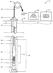
Turning to the drawings, exemplary embodiments of a system and methods for
determining wellbore inclination are shown. In Fig. 1, for example, a
simplified
representation of WL well survey system 10 is shown. In general, WL well
survey
system 10 is shown as including bottom hole assembly (BHA) 20 within wellbore
100. In
particular, BHA 20 includes drill collar 30, which along with drill pipe 35
forms a drill
3o string. BHA. 20 may also include a drilling motor assembly, one or more
stabilizers, a
Atty. Dkt. No. 5840-00100 Page 18 Conley Rose, P.C.
CA 02462051 2004-03-24
survey tool and a drill bit. For clarification purposes, however, only drill
bit 25 and drill
collar 30 are illustrated in Fig. 1.
To initiate drilling, BHA 20 and the attached drill string are lowered towards
the
surface of the earth through casing 40, as shown in Fig. 1. During drilling,
drill bit 25 is
rotated by rotary motion of the drill string or rotated via a drilling motor
to cut through
geological formations and thereby create wellbore 100. Though not illustrated
in the
embodiment of Fig. I, the system used to rotate the drill string typically
includes a rotary
table, which is mounted upon a floor 50 and rotated by a prime mover (such as
an electric
motor) at a desired rotational speed. A drilling fluid from a mud pit is
circulated under
pressure through the drill string by a mud pump. The drilling fluid emerges
through
nozzles in drill bit 25 at the bottom of the wellbore and circulates uphole
through a space
between the drill string and the wellbore to return to the mud pit. In this
manner, the
drilling fluid functions to remove drill cuttings from the bottom of the
wellbore. As will
be described in more detail below, the drilling fluid may function as a
communication
path between BHA 20 and surface instrumentation.
WL well survey system 10 also includes survey tool 60 for monitoring the
position and direction of BHA 20 and to enable restriction of drilling
activity to the
planned wellbore path. In a preferred embodiment, survey tool 60 is
substantially
equivalent in size to the conventional CVD tool, and thus, is configured for
insertion
within running gear 70. In this manner, survey tool 60 may be run into
wellbore 100 by
survey cable 80, which is connected to running gear 70 and spooled from a
cable drum
(not shown) mounted on the drill floor 50. With the assistance of pulley 90,
the cable
drum is configured to raise and lower survey tool 60 within the drill string.
In WL survey systems, survey tool 60 may be dropped ar lowered through the
drill
string to land on centralizing ring 27 above drill bit 25. As stated above,
ring 27 may also
be referred to as a "landing ring" or ''Totco ring." Landing ring 27 functions
to position
3o survey tool 60 in alignment with the direction of drill bit 25, and thus,
in substantial
Arty. Dkt. Vo. 5840-00100 Page l9 Coniey Rose. P.C.
CA 02462051 2004-03-24
alignment with a longitudinal axis of the wellbore. To eliminate some of the
shock
associated with landing, shock absorber 75 may be included at the bottom of
running gear
70 between survey tool 60 and landing ring 27. In some cases, survey tool 60
may
include a means for communicating signals to the earth's surface via one of
several
methods described below.
Though not illustrated in the accompanying drawings for purposes of brevity,
MWD and MAD survey systems are also considered within the scope of the present
invention. In MWD and MAD survey systems, for example, a survey tool may be
l0 included as a component of the BHA, and thus, fixedly attached within the
drill string
near the drill bit. In particular, MWD and MAD survey tools are generally
built into short
drill collars that are screwed into the BHA, as opposed to WL survey tools,
which are
included within the running gear assemblies. Since MWD and MAD survey tools
are
embodied within the BHA during drilling activity, they do not require the use
survey
cables, shock absorbers or landing rings. MWD and MAD survey systems may,
however,
include a communications subassembly for transmitting signals to the earth's
surface via
one of several methods described below.
Whether utilized in WL, MWD or MAD applications, well survey systems may
2o include a variety of surface instrumentation including, but not limited to,
surface
computer terminal 110 and tooUsystem interface 120. In some cases, surface
computer
terminal 110 may comprise only a display device, such as display device 470 of
Fig. 4,
for displaying data received from survey tool 60 via tool/system interface
120. In other
cases, surface computer terminal 110 may include a simple processor, such as
processor
410 of Fig. 4, in addition to display device 470. As shown in Fig. 4, however,
surface
computer terminal 110 preferably includes processor 410 coupled to memory
device 400
via memory bus 420. Surface computer terminal 110 may also include clock
device 430,
communication (COMM) port 450, input device 460 and display device 470 each
coupled
to processor 410 via system bus 440. In some cases, surface computer terminal
110 may
be a personal computer (PC), and thus, may include additional circuitry and
components
Atty. Dkt. ~lo. 5840-00100 Page 20 Conley Rose. P.C.
CA 02462051 2004-03-24
appropriately found with a PC. However, surface computer terminal 110 may be
any
other computational device such as, e.g., a personal digital assistant
("PDA"). Surface
computer terminal 110 may also include other peripheral devices 480, such as a
printer,
network adapter or modem.
In some cases, tool/system interface 120 is operably coupled to COMM port 450
of surface computer terminal I 10 via electrical, optical, infrared or any
other appropriate
means of signal transmission. In other cases, however, tool/system interface
120 may be
an internal component of surface computer terminal 110. In any case,
tool/system
to interface 120 is configured to receive and transmit signals from survey
tool 60 to surface
computer terminal 110 for processing, storage and/or display purposes. As
such,
tool/system interface 120 may be configured to receive signals from survey
tool 60 via
electrical, "mud pulse", or electromagnetic (EM) transmission. In general, the
medium
chosen for transmission is dependent on the type of survey system used.
In a WL or MAD survey system, for example, tool/system interface 120 may be
configured for coupling to an input/output (I/O) port of survey tool 60 after
the tool is
retrieved from wellbore 100. Such coupling may include direct attachment
between the
I/O port of survey tool 60 and tool/system interface 120, or alternatively,
may include
indirect attachment through a wire or cable. It may not be necessary, however,
to retrieve
survey tool 60 before signal transmission can occur between survey tool 60 and
tool/system interface 120. For example, signals may be transmitted via an
electrical wire
coupled between survey tool 60 and tool/system interface 120 while survey tool
60 is
downhole. It may be preferred, however, that survey tool 60 be retrieved after
a WL or
MAD survey and operably coupled to tool/system interface 12U for purposes of
simplification and the reduced likelihood of problems associated with remote
signal
transmission.
Atty. Dkt. ~Io. 5841)-00100 Patio 21 Conley Rose, P.C.
CA 02462051 2004-03-24
In a MWD survey system, signals may be transmitted between a communication
subassembly and tool/system interface 120 via "mud pulse" andlor
electromagnetic
("EM") transmission. In general, "mud pulse" transmission is a known type of
communication in which pressure signals are transmitted through the dolling
fluid to a
s pressure sensor coupled at the surface to tool/system interface 120. EM
transmission, on
the other hand, involves transmission and detection of a low frequency
electromagnetic
propagation wave through the wellbore formation to an antenna coupled at the
surface to
tool/system interface 120.
to Fig. 2 is a block diagram illustrating exemplary components within survey
tool
60. Generally speaking, survey tool 60 includes at least one processing device
and at
least one tilt-sensing device. It may be preferred, however, that survey tool
60 also
include system processor 200, sensor processor 210 and one or more tilt-
sensing devices
220. As will be described in more detail below in reference to Figs. 3A and
3B, tilt-
t5 sensing devices 220 preferably include one or more electrolytic tilt
sensors. For example,
electrolytic tilt sensors may be preferred over accelerometers due to the
relatively small
size of electrolytic tilt sensors (e.g., approximately 0.4" in diameter) as
compared to the
size of some accelerometer devices (e.g., approximately 1.25" in diameter).
The
relatively small size of electrolytic tilt sensing devices enables their use
as a drop-in
2o replacement for the conventional mechanicai CVD survey tool. Signal
transmission
between survey tool 60 and tool/system interface 120 (in a WL or MAD survey
system)
or a communication subassembly (in a MWD survey system) occurs via 1/O pins
270.
As shown in Fig. 2, system processor 200 is adapted to transmit a signal
(Tx[1:N])
25 to and receive a signal (Rx[1:M]) from sensor processor 210. In general,
transmit signal
Tx[1:N] is an "enable signal" and may, in some cases, communicate to sensor
processor
210 when a sensor measurement is to be taken with tilt-sensing devices 220. In
other
cases, however, the enable signal may only initiate transmission of Rx[l:M]
from sensor
processor 210 to system processor 200. In any case, signal Rx[1:M] may include
raw
3o sensor data from tilt-sensing devices 220 and/or processed sensor data from
sensor
.4tty. Dkt. No. 1840-00100 Pagc 22 Couley Rose, P.C.
CA 02462051 2004-03-24
processor 210. 'The means for processing the raw sensor data and results
thereof (i.e., the
processed sensor data) will be described in more detail below in reference to
Figs. 3A, 3B
and 5.
The raw and/or processed sensor data may then be transferred to memory device
230 for storage therein. In a preferred embodiment, however, only processed
sensor data
is stored within memory device 230 to thereby minimize the required storage
capacity of
memory device 230. Memory device 230 may include, for example, a
reprogrammable
non-volatile storage device, such as a non-volatile random access memory
(NVRAM)
to device, an erasable programmable read-only memory (EPROM) device, an
electrically
erasable programmable read-only memory (EEPROM) device, or a FLASH memory
device. The type and storage capacity of memory device 230 may be
appropriately
selected to accommodate a specific application.
t5 As shown in Fig. 2, survey tool 60 preferably includes clocking device 240.
In a
preferred embodiment, clocking device 240 is a real-time clock for tracking
the current
time not only in terms of hours, minutes and seconds, but also in terms of
days, months
and years. Such a real-time clock may be beneficial for precisely tracking an
internal
survey time. As described herein, a "survey time" refers to one or more time
intervals
20 during which tilt-sensing devices 220 are obtaining one or more sensor
measurements.
Alternatively, clocking device 240 may include any other appropriate means for
tracking
irme.
Survey tool 60 may also include power supply 250, in some embodiments. For
25 example, power supply 250 may be a voltage regulator, i.e., a circuit or
device that
provides a constant voltage to a load. Voltage regulators are commonly known
in the art,
and thus, will not be discussed in detail herein. It will be noted, however,
that power
supply 250 may be used, in some cases, to regulate a reference voltage (e.g.,
V~ at
voltage input pin 260) received from a battery unit (not shown). Such a
battery unit may
30 be included within survey tool 60, or alternatively, within the BHA of a
MWD or MAD
Atry. Dkt. No. 5840-00100 Pagc 23 Conley Rose, P.C.
CA 02462051 2004-03-24
survey system. It is also noteworthy to mention that the minimal power
consumption of
tilt-sensing devices 220 may be responsible, in part, for allowing battery
operation of
survey tool 60. In other cases, however, power supply 250 may regulate a
reference
voltage received from a power source external to survey tool 60. Such a power
source
may reside within surface instrumentation, or alternatively, be generated by
rotational
motion of certain BHA components.
In some embodiments, survey tool 60 may also include optional shock sensor
280.
In general, shock sensor 280 may be any discrete device capable of detecting
vibration
io associated with motion and/or a "shock event." As described herein, a shock
event may
indicate the landing of a survey tool in a WL application, or may indicate the
presence of
drilling activity in a MWD application. In some cases, a shock event may also
indicate
problematic drilling conditions such as "stick slipping" of the drilling bit
or excessive
vibrations of the BHA. In general, shock sensor 280 may be comprised of an
electrical
switching device, which closes each time sensor 280 experiences significant
shock. In
particular, shock sensor 280 may be comprised of, for example, an
accelerometer switch
or a shock counter device.
In MWD or MAD survey systems, survey tools are often required to run many
2o times longer than when deployed in a WL survey system. In some embodiments,
therefore, survey tool 60 may also include power management switch 255 coupled
between shock sensor 280 and system processor 200. In general, power
management
switch 255 is configured to force the survey tool into a "sleep mode" during
times in
which shock is detected by shock sensor 280. In some cases, measurement data
may not
be obtained during such a sleep mode. In addition, power management switch 255
allows
measurement data to be obtained during "wake modes," or times after which
substantially
no shock is detected for a predefined period of time (e.g., 30 seconds). In
this manner,
power management switch 255 allows the survey tool to be switched "off' during
drilling
activity to thereby conserve power consumption of the survey tool.
Atty. Dkt. No. 5840-00100 Page 24 Conlev Rose. P.C.
CA 02462051 2004-03-24
In some embodiments, survey tool 60 may also include optional sensor selection
means 290 for selecting one tilt-sensing device from the plurality of tilt-
sensing devices
220 included within the housing. In particular, sensor selection means 290 is
configured
to select an appropriate tilt-sensing device when each of the plurality of
devices 220
exhibits a different operational range. In some cases, sensor selection means
290 may
include another sensing device such as, e.g., an accelerometer device, for
selecting the
tilt-sensing device having the appropriate operational range. In other cases,
sensor
selection means 290 may include a selection device such as, e.g., a
multiplexer, For
sequentially selecting each one of the plurality of tilt-sensing devices 220.
An exemplary
t0 method for using sensor selection means 290 to select the one tilt-sensing
device is
discussed in more detail below in reference to Figs. 7 and 8.
As described above, tilt-sensing devices 220 preferably include one or more
electrolytic tilt-sensing devices; the configuration and operation of which
will now be
described in reference to Figs. 3A and 3B. Generally speaking, electrolytic
tilt-sensing
devices are adapted to provide an output voltage, which is proportional to a
tilt angle and
phase (i.e., tilt direction) associated with the tilt-sensing device. In
particular, the output
voltage is derived from a change in resistance between a plurality of
electrodes immersed
within an electrolyte, and is a function of the amount of tilt experienced by
the electrolyte
due to the force of gravity.
More specifically, an electrolytic tilt sensor is shown in Fig. 3A as
comprising a
housing 300, which is partially filled with an electrolytic solution 310 (also
referred to as
an electrolyte). Though housing 300 is usually formed of glass, it may
alternatively be
formed of any suitable non-conductive material. As shown in Fig. 3A, housing
300
encloses a plurality of electrodes 320, which are uniformly immersed in
electrolytic
solution 310 when the tilt sensor is in an upright (i.e., zero tilt or
electrical null) position.
One of the electrodes (e.g., a center electrode) is a common electrode,
whereas the
remaining electrodes are sensing electrodes. The sensing electrodes are
grouped into one
Atty. Dkt. No. 5840-00100 Page 25 Conley Rose, P.C.
CA 02462051 2004-03-24
or more pairs for defining (in conjunction with the common electrode} one or
more
orthogonal axes of the tilt sensor.
As shown in Fig. 3A, for example, a single-axis electrolytic tilt sensor may
include a common electrode (e.g., electrode b) and one pair of sensing
electrodes (e.g.,
electrodes a and c). A dual-axis electrolytic tilt sensor (not shown), on the
other hand,
may include a common electrode and two pairs of sensing electrodes. In a dual-
axis
sensor configuration, each of the pairs of sensing electrodes is sensitive
along a different
orthogonal axis of the tilt sensor. A tri-axis electrolytic tilt sensor (not
shown) having
to three or more pairs of sensing electrodes may also be configured, such that
each pair
(along with the common electrode) provides a measure of tilt along each of the
three
orthogonal axes of the tilt sensor. As wilt be described in more detail below,
however,
tilt measurements may only be needed along two of the three orthogonal axes of
the tilt
sensor for accurately determining the inclination of a wellbore.
Tilting the electrolytic tilt sensor away from the upright position causes
each of
the sensing electrodes to become more or less immersed in the electrolytic
solution, while
the surface of the electrolytic solution remains substantially level due to
gravitational
forces. Due to the electrical conductivity of the electrolytic solution,
however, an
2o increase or decrease in immersion may cause a corresponding change in
resistance
between any one of the sensing electrodes and the common electrode. This
change in
resistance is measured by an electrical circuit (e.g., a Wheatstone bridge,
not shown) and
correlated to a tilt angle and/or tilt direction, depending on the number of
sensing
electrodes and type of electrical circuit being used.
Conventionally, electrolytic tilt-sensing devices have been used in a variety
of
applications, such as weapons delivery and aircraft navigation, to determine
the amount
of tilt experienced by a tilting apparatus (e.g., an aircraft) with respect to
a coordinate
system defined by the tilting apparatus. In other words, electrolytic tilt
sensors have been
used to measure rotation (i.e., the amount of tilt) about one or more axes of
a tilting
Atty. Dkt. No. 5840-00100 Pale 26 Coaley Rose, P.C.
CA 02462051 2004-03-24
apparatus. However, electrolytic tilt sensors have not been used to directly
determine the
amount of tilt experienced by a structure (e.~., a wellbore), which is
unattached to the
tilting apparatus (e.g., a survey tool). More specifically, the present
inventors are
unaware of prior means for determining the inclination of a wellbore using
electrolytic
tilt-sensing devices without also using other positioning sensors, such as
accelerometers
and gyroscopes.
A means for determining the orientation of a tilting apparatus using
electrolytic
tilt-sensing devices in combination with tri-axis accelerometers has been
disclosed, for
t0 example, in U.S. patent No. 5,606,124 to Doyle et al. (hereinafter
"Doyle"). More
specifically, Doyle discloses an apparatus and method for determining the
gravitational
orientation of a well logging instrument (i.e., a survey tool), which utilizes
both
electrolytic tilt-sensing and accelerometer devices. Doyle, however, fails to
suggest that
the orientation of a wellbore could be dete~nined using only measurements
obtained from
t5 an electrolytic tilt-sensing device. In fact, Doyle uses an electrolytic
tilt-sensing device
merely for calibrating the error prone accelerometer measurements. As such,
one of
ordinary skill in the art would not necessarily conclude, in light of Doyle,
that electrolytic
tilt sensor measurements could be used alone (i.e., without combined use with
measurements from accelerometer devices or other orientation sensors) to
determine the
2o inclination of a wellbore.
Therefore, a novel means is disclosed herein for determining the inclination
of a
wellbore without the need for other orientation sensors, such as accelerometer
and
gyroscope devices, conventionally used to determine the same. In particular,
the present
25 invention provides a survey tool, such as survey tool 60 of Fig. 1, having
one or more
electrolytic tilt-sensing devices fixedly coupled therein. As mentioned above,
survey tool
60 may include a dual-axis electrolytic tilt-sensing device, or alternatively,
may include
two single-axis electrolytic tilt-sensing devices. The choice between single-
axis and
dual-axis devices is generally application specific and may be dependent on
desired cost,
30 accuracy, and operational range, in most cases. For example, two single-
axis electrolytic
Atty. Dkt. No. 5840-00100 Paee 27 Conley Rose. P.C.
CA 02462051 2004-03-24
tilt sensors may be positioned along orthogonal axes of the tilt sensor when
increased
accuracy (e.g., ~ 0.1 degrees) is desired over a reduced range (e.g., 0-5
degrees) of
measurable tilt angles. However, a dual-axis electrolytic tilt sensor may be
preferred
when a reduction in cost (e.g., dual-axis sensors are approximately a factor
of 10 cheaper
than single-axis sensors) is desired in addition to an increased operational
range (e.g., 0-
180 degrees).
In any case, one or two electrolytic tilt sensors are sufficient to accurately
determine the inclination of a wellbore, as opposed to other positioning
sensors, which
generally require three or more sensors to obtain a similar accuracy. Such an
advantage
may be due, in part, to the customization of electrolytic tilt sensors and the
resultant
reduction in sensor sensitivity to changes in the operational environment. In
other words,
electrolytic tilt sensors can be tailored for operation within a specific
environment by
selecting appropriate compositions and configurations for electrolytic
solution 310 and/or
electrodes 320.
For example, an electrolyte (i.e., an electrolytic solution) is generally
comprised of
a salt capable of conducting an electrical charge and one or more solvents. In
some cases,
the chemistry of electrolytic solution 310 may be selected to accommodate the
higher
temperatures and increased vibrations normally encountered during a well
survey. To
accommodate vibrations, for example, a higher salt concentration may be
selected to
increase the viscosity of the electrolyte and further dampen the time response
of the tilt
sensor. To accommodate higher temperatures, on the other hand, a solvent
having a
higher boiling point may be selected for the electrolyte chemistry.
Alternatively, or in
addition to, the volume of electrolytic solution 310 may be appropriately
chosen to
maximize the accuracy of the sensor. For example, increasing the volume of the
electrolyte effectively increases the resolution (and therefore, the accuracy)
of the sensor
by increasing the amount of fluid that is displaced (i.e., the total volume of
the change in
the fluid) when the sensor is tilted.
Auy. Dkc. No. 5840-00100 Page 28 Conley Rose. P.C.
CA 02462051 2004-03-24
The electrolytic salts and solvents available for use in electrolytic solution
310 are
commonly known, and thus, are not fully described herein. In a preferred
embodiment,
however, electrolytic solution 310 may include electrolytic salts that are
less susceptible
to electrolytic breakdown and solvents, which are capable of withstanding
temperatures
between approximately -20° C and +150° C. Tailoring the
electrolytic solution for use in
a particular application is well known in the an; thus, the exact composition
of
electrolytic solution 310 will not be discussed herein. Substantially any
combination of
commonly known salts and solvents may be included within electrolytic solution
310.
tU The material composition of electrodes 320 may also be chosen (with regard
to
the chosen electrolyte) to ensure a stability of the electrolytic tilt sensor
over time and
with changes in temperature. As noted above, such stability may advantageously
eliminate the need for periodic recalibration and/or the need to correct
sensor
measurements for undesirable errors and biases. Generally speaking, an
electrolytic tilt
t5 sensor (and accompanying circuitry) provides an output voltage, which is
correlated to the
tilt angle experienced by the sensor. Therefore, to ensure accurate and
reliable operation
over time and temperature, the electrical parameters of the tilt-sensing
device must
remain stable. In particular, a stable resitivity of electrolytic solution 310
may be required
for the output voltage to remain accurately correlated to tilt angle.
As such, the material composition of electrodes 320 may be selected, in some
cases, from a variety of precious metals known for their chemical stability.
In this
manner, precious metal electrodes may be chosen to suppress electrochemical
reactions,
which would otherwise cause an undesirable change in the electrolyte
resitivity.
Alternatively, the material composition of electrodes 320 may be selected from
a variety
of non-precious metals, in other cases. However, an appropriate electrolyte
must be
chosen to suppress the electrochemical reactions caused, in part, by the use
of a non-
precious metal electrode. Alternatively, electrodes 320 may include a non-
precious metal
having a precious metal coating or a non-metallic material having a precious
metal
coating.
Atty. Dkt. No. 584D-OO1D0 Paee 29 Conley Rose, P.C.
CA 02462051 2004-03-24
Fig. 3B is a vector diagram used herein to describe the relationship between
electrolytic tilt sensor measurements and the calculated wellbore inclination
angle. For
example, Fig. 3B shows survey tool 60 as having an (x,y,z) coordinate system,
where the
x- and y-axes refer to transverse axes while the z-axis refers to a
longitudinal axis of the
survey tool. Note, however, that Fig. 3B is shown in an upside down position
for
purposes of drawing simplicity. In reality, the gravitational vector, G,
denotes a true
vertical direction, thus, the z-axis may be described herein as roughly
directed in a
downward course.
to When using electrolytic tilt sensors, wellbore inclination may be
accurately
determined by measur7ng the amount of tilt associated with the transverse axes
(i.e., the
x- and y-axes) of the survey tool. As such, a dual-axis tilt sensor may be
fixedly attached
within survey tool 60, in some cases, for measuring a tilt angle within each
of the
transverse planes of the survey tool- These transverse planes are shown in
Fig. 3B as
1S orthogonal X-Z and Y-Z planes. In other cases, however, a single-axis tilt
sensor may be
fixedly attached along each of the transverse axes of survey tool 60 for
measuring tilt
angles within the X-Z and Y-Z planes. As will be described in more detail
below, the tilt
angles, 8~ and 6YZ, measured within each of the transverse planes can be used
to
determine the inclination angle, Ow, which lies within an inclination plane of
the of
20 survey tool 60. As used herein, the term "inclination plane" refers to the
two-dimensional
space defined by the longitudinal axis of survey tool 60 and the gravitational
vector.
As such, Fig. 3B illustrates the relationship between the tilt angles, 8~ and
BYZ,
measured by electrolytic tilt-sensing devices 220 and the inclination angle,
8w. For
25 example, Fig. 3B describes tilt angle 6~ as the angle between the
projection of G onto
the X-Z plane (denoted as gXZ) and the z-axis of the survey tool. Similarly,
the tilt angle
6YZ is described in Fig. 3B as the angle between the projection of G onto the
Y-Z plane
(denoted as gyZ) and the z-axis of the survey tool. Therefore, when the z-axis
of survey
tool 60 is in substantial alignment with the longitudinal axis of the
wellbore, the
3o inclination angle, 6W, can be described as:
4tty. Dkt. No. 5840-00100 Page 30 Conley Rose, P C.
CA 02462051 2004-03-24
~,t, = tan B~Z + tan B~ Equ. (1)
In some embodiments; the alignment between the z-axis of survey tool 60 and
the
longitudinal axis of the wellbore is due to the landing of survey tool 60 onto
landing ring
27. As noted above, landing ring 27 functions to position survey tool 60 in
alignment
with the direction of drill bit 25, and thus, in substantial alignment with
the longitudinal
axis of the wellbore. In such embodiments, the inclination angle, Ow, also
indicates the
inclination of the wellbore.
Exemplary methods for conducting a well survey using survey tool 60 will now
be
described in reference to Figs. 5-9. Fig. 5, for example, illustrates an
exemplary method
for determining the inclination of a wellbore using survey tool 60. Though not
shown in
Fig. 5, the method generally begins by lowering or dropping survey tool 60
into a
wellbore to conduct a WL survey. Alternatively, drilling activity may be
periodically
stopped to conduct a MWD or MAD survey. In step 500, the method may continue,
in
some embodiments, by measuring a first tilt angle (e.g., tilt angle 0~) within
a first plane
(e.g., the X-Z plane) and a second tilt angle (e.g., tilt angle OYZ) within a
second plane
(e.g., the Y-Z. plane) of electrolytic tilt-sensing devices 220. In step 510,
an inclination
value may be calculated by plugging the first and second tilt angles into Eqn.
(1), as
described above. If only one survey measurement (i.e., one pair of measured
first and
second tilt angles) is obtained during the well survey, the calculated
inclination value is
selected as inclination of the wellbore (e.g., inclination angle Aw) in step
550.
In other embodiments, however, it may be desirable to obtain more than one
survey measurements during a well survey. As such, step 500 preferably
includes
measuring a plurality of first and second tilt angles for each of a plurality
of time
intervals. In one example, 10-20 survey measurements may be taken for each of
the
plurality of time intervals. However, the number of survey measurements per
time
interval is not limited to such an example, and may alternatively include any
reasonable
number. The plurality of time intervals may include, in some cases, distinct
time
Atty. Dkt. No. 5840-OO100 Paee 31 Conley Rose. P.C.
CA 02462051 2004-03-24
intervals (e.g., I-second time intervals) individually separated by a period
of time (e.g., a
10-second time period) in which no measurements are taken by electrolytic tilt-
sensing
devices 220. In other cases, the plurality of time intervals may include a
plurality of
continuous time intervals (e.g., 1-second time intervals) over which a
continuous stream
of survey measurements is taken by electrolytic tilt-sensing devices 220.
Note, however,
that substantially any length of time may be used to describe the distinct
time intervals
and intermediate time periods, or alternatively, the continuous time
intervals.
In some cases, the plurality of first and second tilt angles may be measured
while
t0 survey tool Ei0 is held stationary within the wellbore. For example, a
plurality of survey
measurements may be taken after survey tool 60 has landed (e.g., on landing
ring 27) at
the bottom of the wellbore. Alternatively, the plurality of survey
measurements may be
taken at times when survey tool 60 is temporarily stopped at one or more depth
locations
within the wellbore. In other cases, however, it may be desirable to obtain
survey
measurements while survey tool 60 is moving through the wellbore, in addition
to the
measurements obtained while survey tool 60 is held stationary within the
wellbore. As
will be described in more detail below, such a case may increase the accuracy
of the
calculated wellbore inclination angle through the disqualification of
measurements taken
while the tool is in motion.
In step 510, a set of inclination values may be calculated from the plurality
of first
and second tilt angles measured during each of the plurality of time
intervals. Each
inclination value may be calculated, for example, by plugging a corresponding
pair of
first and second tilt angles into Equ. (1). In this manner, a "set of
inclination values"
refers to the inclination values calculated from each pair of first and second
tilt angles
measured during a particular time interval. Subsequently, the method continues
by
calculating an average inclination value (in step S20) and a deviation value
(in step 530)
for each set of inclination values. Each deviation value may be calculated,
for example,
as a standard deviation of a particular set of inclination values. However,
any other
appropriate statistical calculation known in the art can alternatively be used
to calculate
Atty. Dkt. No. X840-OO100 Page 32 Conley Rose, P.C.
CA 02462051 2004-03-24
the deviation value. As will be described in more detail below, deviation
values may be
used to indicate motion or vibration associated with the survey tool.
As noted above in the discussion of Fig. 2, "raw sensor data" is used herein
to
describe the tilt angles, which are measured by electrolytic tilt sensors 220
and sent to
sensor processor 210. In some cases, sensor processor 210 may be adapted to
determine
and transmit the inclination values as "processed sensor data" to system
processor 200.
In such a case, system processor 200 may be adapted to determine the average
inclination
and deviation values from the processed sensor data. In other cases, however,
sensor
to processor 210 may be further adapted to determine and transmit the average
inclination
and deviation values as "processed sensor data" to system processor 200. In
such a case,
the inclination values may or may not be transmitted to system processor 200,
depending
on, e.g., the storage capacity of memory device 230.
In step 540, the raw sensor data and/or processed sensor data may be stored
within
memory device 230. As noted above, however, only the processed sensor data may
be
stored within memory device 230 if a reduced storage capacity is desired. In a
preferred
embodiment, the raw and/or processed sensor data is correlated to a
corresponding time
interval before storage within the memory device. In this manner, memory
device 230
z0 may include a time-based well log comprising some or all of the raw data
measurements,
the set of inclination values, the average inclination value, and the
deviation value
associated with each of the stored plurality of time intervals.
In step 550, the inclination of the wellbore may be determined by selecting at
least
one of the average inclination values stored within the time-based well log.
In.some
cases, step 550 may occur while survey tool 60 is disposed within the
wellbore. As such,
system processor 200 may be adapted, in one example, to determine the
inclination of the
wellbore. In particular, system processor 200 may utilize an algorithm stored
within
memory device 230 to determine the inclination of the wellbore by selecting an
3o appropriate average inclination value. Means for selecting the
"appropriate" average
Atty. Dkt. No. 5840-00100 Page 33 Conlev Rose. P.C.
CA 02462051 2004-03-24
inclination value will be described in more detail below. After retrieving
survey tool 60
from the wellbore, the selected wellbore inclination angle may be displayed on
an
external panel of the survey tool and/or downloaded for display upon display
device 470
of surface computer terminal 110.
In another example, however, the data within memory device 230 may be
transmitted up-hole to surface computer terminal 110 via any of the signal
transmission
means described above in reference to Figs. I and 2 (e.g., by electrical, "mud
pulse," or
EM transmission). As such, processor 410 may utilize an algorithm stored
within
io memory device 400 to automatically select the appropriate wellbore
inclination angle.
Alternatively, the transmitted data may be displayed upon display device 470
for allowing
a system operator to manually select the appropriate wellbore inclination
angle.
Subsequently, the selected wellbore inclination angle may be displayed to the
operator
(via, e.g., display device 470 or peripheral devices 480) and/or stored within
memory
device 400.
In other cases, however, step 550 may occur at the surface after survey tool
60 is
retrieved from the wellbore. For example, the data stored within memory device
230 may
be downloaded to surface computer terminal 110 via tool/system interface 120,
as
described above. Next, the appropriate wellbore inclination angle may be
automatically
selected by processor 410 or manually selected by an operator. For example,
the
appropriate wellbore inclination angle may be automatically or manually
selected from a
subset of inclination angles corresponding to relevant wellbore depths and/or
requested
survey time periods, which will be described in more detail below.
Subsequently, the
selected wellbore inclination angle may be displayed to the operator and/or
stored within .
memory device 400.
Whether performed automatically or manually, uphole or downhole, the means for
selecting an "appropriate" wellbore inclination angle may include selecting an
average
3o inclination value having a corresponding deviation value less than a
predefined threshold,
Atty. Dkt. No. 5840-00100 Page 34 Conley Rose, P.C.
CA 02462051 2004-03-24
in some cases. As noted above, deviation values may be used herein as an
indication of
motion or vibration associated with the survey tool. In particular, a
relatively high
deviation value (e.g., substantially greater than 5% of the average deviation
value) may
indicate the presence of significant motion or vibration, whereas a relatively
low
deviation value (e.g., approximately 0-5%) may indicate little to no motion or
vibration.
Since a decrease in motion and vibration increases the accuracy of a survey
measurement,
it may be beneficial to select an average inclination value having a
corresponding
deviation value substantially less than 5%. Note, however, that alternative
threshold
values may be equally viable depending on the specific application in which
they are
l0 applied.
In an alternative embodiment, the method may include determining a vibration
value for each set of inclination values. Vibration values may be detected,
for example,
by a separate shock sensor (e.g., shock sensor 280 of Fig. 2) coupled within
survey tool
60. In some cases, the vibration values may also be included in the time-based
well log
stored within memory device 230. As such, the means for selecting an
"appropriate"
wellbore inclination angle may alternatively include selecting an average
inclination
value having a corresponding vibration value less than a predefined threshold
of (e.g.,
approximately 10 mgs rms). In yet another example, the "appropriate" wellbore
inclination angle may be selected when at least one of a corresponding
vibration value
and a corresponding deviation value is less than their respective predefined
thresholds.
As noted above, inaccurate readings may result when wellbore inclination
angles
are recorded at the wrong time and/or place within a wellbore. In a WL survey
system,
for example, problems with the survey cable may cause a survey tool to become
stuck, at
least temporarily, before the survey tool is allowed to continue through the
wellbore. As
such, inaccurate readings may be taken with prior art survey tools, which are
set at the
surface to obtain a reading after a predetermined and estimated amount of
time. Other
prior survey art tools have tried to overcome these problems by obtaining a
reading a
3o predetermined time delay after a "shock event" is detected. Unfortunately,
such tools
Atty. Dkt. No. 5840-00100 Page 35 Conley Rose. P.C.
CA 02462051 2004-03-24
cannot account for instances in which the survey tool is significantly jarred
(e.g., due to
cable problems) at a location above the bottom surface and becomes stuck for
an amount
of time longer than the predetermined time delay. Therefore, an improved
method is
needed to determine an appropriate place for recording a survey measurement in
a wire
line or MAD survey.
Turning to Fig. 6, an exemplary method is described herein for determining
where
to record a survey measurement. In particular, Fig. 6 illustrates an exemplary
method for
determining when a survey tool has reached a target depth within a wellbore.
As used
to herein, a "target depth" may refer to the lowest point obtainable by a
survey tool disposed
within the wellbore. For example, a survey tool may reach the "lowest point
obtainable"
upon reaching landing ring 27 at the bottom of the driil string.
Alternatively, the "target
depth" may refer to any location of depth at which the inclination of the
wellbore is
desired.
In some cases, the method may begin in step 600 by measuring one or more first
and second tilt angles for each of a plurality of time intervals while the
survey tool is
moving towards the target depth. In other words, a plurality of survey
measurements may
be obtained while a survey tool is dropped or lowered into the weilbore. In
step 610, a set
of inclination values may be calculated from the one or more first and second
tilt angles
measured during each of the plurality of time intervals. In some cases, the
inclination
values may be calculated downhole within the survey tool (e.g., by sensor
processor 210
or system processor 200). Alternatively, the inclination values may be
calculated at the
surface within surface computer terminal 110 (e.g., by processor 410). In such
a case,
however, the raw sensor data must be transmitted in real-time to surface
computer
terminal I10 to avoid an inaccurate determination of target depth.
In step 620, a motion value may be determined for each of the plurality of
time
intervals. In one embodiment, the motion value may include a deviation value
calculated
for each set of inclination values. As noted above, a deviation value may be
calculated by
Atry. Dkt. No. 5840-00100 Page 36 Conley Rose, P.C.
CA 02462051 2004-03-24
finding the standard deviation of a set of inclination values, and may be used
to indicate
motion or vibration associated with the survey tool. As noted above, a
relatively low
deviation value (e.g., approximately 0-510 of the average deviation value) may
indicate
little to no motion or vibration. In an alternative embodiment, the motion
value may
include a vibration value detected (e.g., by shock sensor 280 of survey tool
60) during
each of the plurality of time intervals. As such, a relatively low vibration
value (e.g.,
approximately 0-10 mgs rms) may indicate little to no motion or vibration.
In step 630, it may be determined that the survey tool has reached the target
depth
to when a deviation value is less than a predetermined threshold (e.g.,
approximately 5% of
the average deviation value). Alternatively, it may be determined that the
survey tool has
reached the target depth when a vibration value is less than a predetermined
threshold
(e.g., approximately 10 mgs rms). In some cases, such determination may be
performed
automatically by downhole and/or surface instrumentation, or alternatively,
may be
performed manually by an operator, in other cases. In this manner, the current
method
provides a means for detecting and distinguishing a landing event from other
shock
events that may occur while the tool is moving towards, but has not yet
reached, the target
depth. For example, a shock event followed by vibration or movement would
indicate
that a landing event has not yet occurred.
In addition to determining an appropriate place for recording a survey
measurement, it may further be desirable to provide a means for an operator to
specify an
appropriate time for recording the survey measurement. As such, a simple means
is
provided for allowing an operator to request a survey time period at the
surface without
direct communication with a downhole survey tool. Such means are described
herein
with reference to Figs. 1 and 2.
In particular, sensor means may be included for measuring a plurality of first
and
second tilt angles for each one of a plurality of time intervals. More
specifically, one or
more electrolytic tilt-sensing devices 220 may be used to measure the first
and second tilt
Arty. Dkt. No. 5840-00100 Page 37 Conley Rose, P.C.
CA 02462051 2004-03-24
angles while survey tool 60 is moving through and while survey tool 60 is held
stationary
within the wellbore. In a preferred embodiment, survey tool 60 includes a
processing
means for calculating a set of inclination values from the plurality of first
and second tilt
angles measured during each of the plurality of time intervals. As noted
above, such
processing means may include system processor 200 or sensor processor 210.
Survey
tool 60 may also include a clocking means for tracking the plurality of time
intervals.
Preferably, such clocking means includes clocking device 240, which may be a
real-time
clock, as described above in Fig. 2. In this manner, each of the plurality of
time intervals
may be correlated to a corresponding set of inclination values before storage
of such
to within a time-based well log.
Another clocking means may be included within surface computer terminal 110
for flagging a requested survey time period. As used herein, a "requested
survey time
period" refers to one or more time intervals during which an operator at the
surface
t5 requests survey measurements to be taken. Such clocking means may include
clocking
device 430, which preferably comprises a real-time clock similar to clocking
device 240.
In addition, surface computer terminal 110 may include a processing means,
such as
processor 410, for comparing the requested survey time period with the
plurality of time
intervals tracked by clocking device 240. Such processing means may further be
used for
20 identifying the one or more sets of inclination values that fall within the
requested survey
time period.
In some cases, an operator may request a survey time period at the surface by
entering, for example, one or more survey time periods into I/O device 460 of
surface
25 computer terminal 110. In this manner, the operator may request that one or
more survey
measurements be taken during one or more specified periods of time. In another
example, an operator may request a survey time period by entering one or more
wellbore
depths into I/O device 460. The entered wellbore depths may then be correlated
to time
(e.g., through a time/depth correlation) and/or detected by circuitry within
the survey tool
3o to determine when the one or more survey measurements are requested. For
example,
Atty. Dkt. No. 5840-00100 Page 38 Conley Rose, P.C.
CA 02462051 2004-03-24
circuitry within the survey tool may be configured to detect non-uniformities
in the drill
pipe (e.g., joints between drill pipe sections) to determine the approximate
depth of the
survey tool as it traverses the wellbore. Alternatively, a particular button
or actuator upon
I/O device 460 may be pressed by the operator to flag a cucz-ent time as the
requested
survey time period.
No matter what means are used at the surface to flag the requested survey time
periods, it may be preferred to retrieve the survey tool from the wellbore
before
downloading the time-based well log to the surface computer terminal. For
example,
communication between a downhole survey tool and a surface computer terminal
via any
of the means described above (i.e., mud pulse, EM, or wireline transmission)
is relatively
more expensive (usually by several orders of magnitude) and complex than the
means
described herein. Therefore, the means described herein provide a cost
effective and
simple solution for requesting a survey time period in real time.
As noted above, tilt-sensing devices 220 rnay include, in some cases, a
plurality of
electrolytic tilt-sensing devices each of which are sensitive over a different
range of
inclination angles. As such, Figs. 7 and 8 illustrate exemplary methods for
selecting an
appropriate tilt-sensing device. In particular, Fig. 7 illustrates an
exemplary method for
2o determining wellbore inclination using a survey tool comprising a plurality
of electrolytic
tilt-sensing devices sensitive over consecutive ranges of inclination angles.
For example,
five tilt sensors may be included within survey tool 60, where each sensor is
sensitive
over a different one of the following ranges: ~ 0-10°, ~ 10-20°,
~ 20-30°, ~ 30-40°, ~ 40-
50°. Note, however, survey tool 60 may alternatively include any number
of sensors
comprising any overlapping or non-overlapping ranges of operation.
In step 700, an approximate inclination angle may be determined by sensor
selection means 290 within survey tool 60. As described above in Fig. 2,
sensor selection
means 290 may include an alternative sensing device such as, e.g., an
accelerometer
3o device. In step 710, one of the plurality of tilt-sensing devices may be
selected based on
Atty. Dkt. No. 5840-00100 Paee 39 Conley Rose, P-C.
CA 02462051 2004-03-24
the approximate inclination angle detected by sensor selection means 290.
Returning to
the above example, an approximate inclination angle of IS° would cause
sensor processor
210 to select the tilt sensor having an operational range of ~ 10-20°.
In step 720, first and
second tilt angles are measured with the selected tilt-sensing device, and
used for
detel-mining the inclination of the wellbore in step 730. In this manner, an
inaccurate
reading may be avoided by ensuring the survey measurements are obtained from a
tilt-
sensing device having an appropriate operational range.
Fig. 8, on the other hand, illustrates an exemplary method for determining
1o wellbore inclination using a survey tool comprising a plurality of
electrolytic tilt-sensing
devices sensitive over increasing ranges of inclination angles. For example,
five tilt
sensors may be included within survey tool 60, where each sensor is sensitive
over a
different one of the following ranges: ~ 0-10°, ~ 0-20°, ~ 0-
30°, ~ 0-40°, ~ 0-50°. As
noted above, however, survey tool 60 may alternatively include any number of
sensors
t5 comprising any overlapping or non-overlapping ranges of operation.
In step 800, first and second tilt angles may be measured with a tilt sensor
having
a substantially large range of sensitivity. In some cases, the tilt sensor
having the largest
range of sensitivity (e.g., ~ 0-50°) may be chosen to measure the first
and second tilt
2o angles. In other cases, however, another tilt sensor having a range of
sensitivity
substantially greater than an estimated wellbore inclination angle (e.g., ~ 0-
30°) may be
chosen. In any case, the first and second tilt angles may be re-measured in
step 810 with
a tilt sensor having a smaller range of sensitivity than the previous tilt
sensor range. In
some cases, any tilt sensor having a range smaller than the previous may be
chosen. It
25 may be preferred, however, to select tilt sensors in a sequential manner
from largest to
smallest range of sensitivity. In any case, the tilt sensors may be selected
in some manner
by sensor selection means 290, which as described above in reference to Fig. 2
may be a
multiplexer device.
Atty. Dkt_ No. 5840-00100 Page 40 Conley Rose, P.C.
CA 02462051 2004-03-24
The first and second tilt angles obtained with the current and previous tilt
sensors
are then compared in step 820. In general, "out-of-range" tilt sensors may
exhibit
identical, although erroneous, measured values (i.e., first and second tilt
angles), while a
tilt sensor having an appropriate range may produce a different measured
value. If a
change between the current and previous measured values is not detected in
step 820, the
method may return to step 810 where a tilt-sensing device having an even
smaller range
of sensitivity is used to measure another set of first and second tilt angles.
If a change
between the current and previous measured values is detected in step 820,
however, the
current tilt sensor is selected in step 830 for taking survey measurements
during the well
to survey, In step 840, the inclination of the wellbore may be determined
using survey
measurements obtained by the selected tilt sensor. In this manner, selecting a
tilt-sensing
device having an appropriate operational range may increase the accuracy of
the survey
measurements. For example, less accurate tilt-sensing devices having larger
ranges of
sensitivity may be passed by for tilt-sensing devices having increased
accuracy but
t5 smaller ranges of sensitivity.
In some cases, it may be desirable to provide irrefutable proof that a well
survey
is, in fact, conducted within a wellbore. For example, many prior art survey
tools can be
manipulated to determine a fraudulent wellbore inclination angle while the
survey tool is
20 outside of the wellbore. The fraudulent wellbore inclination angle may then
be presented
as a true measurement to avoid penalties assessed by regulatory bodies. For
these
reasons, a method for determining if a well survey is actually conducted
within a wellbore
will be discussed in reference to Fig. 9.
25 In step 900, the method may begin by obtaining at least one value
associated with
the wellbore using a survey tool, such as survey tool 60. In some cases, step
900 may
obtain at least one motion value during each of a plurality time intervals.
Such a motion
value may include, for example, a deviation value calculated from a set of
inclination
values, which are measured by a tilt-sensing device (e.g., electrolytic tilt
sensors 220)
3o within survey tool 60 during one of the plurality of time intervals. Such a
motion value
Atty. Dkt. No. 5&40-00100 Pagc 41 Conley Rose, P.C.
CA 02462051 2004-03-24
may alternatively include a vibration value, which is detected by a shock
sensor (e.g.,
shock sensor 280) within survey tool 60 during one of the plurality of time
intervals. In
other cases, however, step 900 may obtain at least one temperature value
during each of
the plurality of time intervals. A temperature value may be an ambient
temperature
detected, e.g., by temperature sensor 285 within survey tool 60, during each
of the
plurality of time intervals.
In step 910, a characteristic pattern of the at least one value may be
detected. In
some cases, a characteristic pattern may be detected from the one or more
motion values
l0 obtained in step 900. As noted above, a relatively high motion value
indicates the
presence of significant motion or vibration, whereas a relatively tow motion
value
indicates little to no motion or vibration. Therefore, a characteristic
pattern comprising
motion values greater than a predetermined threshold (as described above)
would provide
evidence of vibration andlor movement associated with a survey tool during the
course of
a well survey. In other cases, however, a characteristic pattern may be
detected from the
one or more temperature values obtained in step 900. Such a characteristic
pattern may
be detected, for example, as a change (or a rate of change) in the temperature
values
obtained during the plurality of time intervals. Since the ambient temperature
within a
wellbore tends to increase with depth, a characteristic pattern of increasing
temperature
values followed by decreasing temperature values would provide evidence of a
survey
tool moving into and then out of a wellbore.
In general, a survey tool should experience a substantially consistent pattern
of
motion and/or temperature values when disposed within a particular wellbore.
In other
words, the measured motion and/or temperature values may be thought of as a
"signature"
of the particular wellbore. Therefore, the characteristic pattern may be
compared (in step
920) with a pattern detected during a previous well survey to determine if the
current well
survey is conducted within the wellbore. If the characteristic pattern is
similar to the
pattern detected during the previous well survey in step 930, it is determined
that the well
3o survey was conducted within the wellbore in step 950. Otherwise, it is
determined that
Atty. Dkc. No. 7840-OO100 Page 42 Conicy Rose, P.C.
CA 02462051 2004-03-24
the well survey was not conducted within the wellbore in step 940. In any
case, the
characteristic pattern and associated measurement data (e.g., raw and/or
processed
measurement data) may be displayed to an operator in step 960. Alternatively,
the
characteristic pattern and associated measurement data may be stored within
memory
device 230 or memory device 400.
It will be appreciated to those skilled in the art having the benefit of this
disclosure that this invention is believed to provide a well survey system
including a
survey tool having one or more electrolytic tilt sensors arranged therein. The
survey tool
t0 disclosed herein provides an accurate determination of wellbore inclination
in either a
WL or MWD application. Such a survey tool is also smaller, less expensive and
more
reliable than other electronic survey tools. Further modifications and
alternative
embodiments of various aspects of the invention will be apparent to those
skilled in the
art in view of this description. It is intended that the following claims be
interpreted to
is embrace all such modifications and changes and, accordingly, the
specification and
drawings are to be regarded in an illustrative rather than a restrictive
sense.
Atty. Dkt. Vo. 5840-00100 Paee 43 Conley Rose, P.C.