Note: Descriptions are shown in the official language in which they were submitted.
CA 02466691 2004-05-07
s '
INERTIAL AUGMENTATION FOR GPS NAVIGATION ON
GROUND VEHICLES
FIELD OF TI-IE INVENTION
The present invention generally relates to the field of global positioning
system
(GPS) based navigation systems for ground vehicles such as tractors, combines,
sprayers,
seeders, or the like, and particularly to a inertial compensation assembly for
a global
positioning system based navigation system that is capable of providing
inertial
compensation for ground vehicle attitude over non-level or uneven terrain.
BACKGROUND OF THE INVENTION
A shortcoming of global positioning system based navigation systems used in
agricultural ground vehicles is that the global positioning system receiver of
such systems
can only determine the position of the global positioning system antenna. On
most
ground vehicles, the mounting location for the global positioning system
antenna is
constrained by the requirement that a clear view of the sky, and thus the
global
positioning system satellites, be provided to the antenna. Unfortunately, this
position is
usually not the desired control point (e.g., the hitch point of a tractor, the
ground vehicle
axle, a point on the ground beneath the hitch point of a tractor, or the
like.) for most
ground vehicle applications. Consequently, when traversing non-level terrain
(e.g.,
terrain having a slope, hills, valleys, or the like), the global positioning
system
determined position and course of the ground vehicle may be incorrect,
resulting in cross-
track and heading errors.
In order to calculate the position of the desired control point, a precise
measurement of the spatial orientation (attitude) of the ground vehicle with
respect to the
navigation coordinate system must be made. One approach to measuring th.e
attitude of
the ground vehicle is to mount multiple global positioning system antennas to
the vehicle
in a fixed, known geometry. When precision global positioning system
measurements
are made, the relative positions of the multiple antennas, as measured in the
navigation
AMS 16132 2
CA 02466691 2004-05-07
frame, can be used to calculate the orientation (position, attitude, and
course) of the entire
ground vehicle. However, a navigation system employing this approach would
require
multiple precision global positioning system receivers and would thus be
prohibitively
expensive.
Alternatively, an inertial system may be used in conjunction with the global
positioning system. In this approach, the inertial system determines the
primary position
and course information for guiding or steering the ground vehicle. Information
provided .
by the global positioning system is then used to correct drift of the position
and course .
information determined by the inertial system. Inertial systems include
gyroscopes for
measuring roll, yaw and pitch, and may include accelerometers for improving
the
accuracy of the information measured by the gyroscopes. Consequently, such
inertial
systems, like multiple antenna systems, are prohibitively expensive for many
applications
Accordingly, it would be desirable to provide an inertial compensation
assembly
or module for a navigation system that employs inertial augmentation to
compensate GPS
based navigation information such as position, course, and track spacing for
errors caused
by variation of the ground vehicle attitude (i.e., roll and yaw) over non-
level terrain, but
which does not require the full suite of gyroscopes and accelerometers
provided by a
conventional inertial system.
SUMMARY OF THE INVENTION
The present invention is directed to an inertial compensation assembly for the
navigation system of a ground vehicle, in particular an agricultural ground
vehicle such
as a tractor, combine, cotton picker, sprayer, or the like. The navigation
system employs
inertial augmentation to compensate global positioning system based navigation
information such as position, course, track spacing, or the like, for errors
caused by
variation of ground vehicle attitude (i.e., roll and yaw) over non-level or
uneven terrain.
In this manner, the accuracy of the navigation system is increased without.
undue
expense.
AMS 16132 . 3
CA 02466691 2004-05-07
In accordance with a first aspect of the present invention, an inertial
compensation
assembly for a navigation system of a ground vehicle is disclosed. In an
exemplary
embodiment, the inertial compensation assembly includes a gyroscope assembly
for
determining a yaw angle for the ground vehicle, an accelerometer assembly for
determining a lateral acceleration of the ground vehicle, and a processing
system coupled .
to the gyroscope assembly and accelerometer assembly. The processing system
uses the
determined yaw angle and the lateral acceleration to correct the position and
course
information generated by a global positioning system receiver assembly of the
navigation
system employing the inertial compensation assembly, so that the position and
course
information used by the navigation system is inertially compensated for roll
and yaw of
the ground vehicle as the ground vehicle traverses non-level terrain. The
processing
assembly may further calculate the slope of the non-level terrain being
traversed by the
ground vehicle allowing the effective track spacing of an implement associated
with the
ground vehicle (e.g., towed by the ground vehicle or mounted to the ground
vehicle) to be
calculated.
In accordance with a second aspect of the present invention, a method for
determining position and course information for a ground vehicle is disclosed.
In an
exemplary embodiment, the method includes the steps of receiving a global
positioning
system based position and course from a global positioning system, measuring
the yaw
angle for the ground vehicle using a gyroscope assembly, measuring the lateral
acceleration of the ground vehicle using an accelerometer assembly, and
calculating .
position and course information for the ground vehicle by correcting the
global
positioning system based position and course using the determined yaw angle
and lateral
acceleration so that the calculated position and course information is
inertially
compensated for roll and yaw of the ground vehicle as the ground vehicle
traverses non-
level terrain. The method may further include the step of calculating the
slope of non-
level terrain traversed by the ground vehicle in order to determine the
effective track
spacing of an implement associated with the ground vehicle (e.g., towed by the
ground
vehicle or mounted to the ground vehicle).
AMS 16132 4
CA 02466691 2004-05-07
b
In accordance with a third aspect of the present invention, a navigation
system for
a ground vehicle is disclosed. The navigation system includes a global
positioning
system receiver assembly for receiving a positioning signal from a global
positioning
system and generating a global positioning system based position and course
for the
ground vehicle and a steering system interconnected with the global
positioning system
receiver assembly for steering the ground vehicle using the position and
course
information. An inertial compensation assembly is coupled to the global
positioning
system and navigation control system for determining corrected position and
course
information for the ground vehicle that may be utilized by the navigation
control system
for navigating andlor steering the ground vehicle. In an exemplary embodiment,
the
inertial compensation assembly includes a gyroscope assembly for determining a
yaw
angle for the ground vehicle, an accelerometer assembly for determining a
lateral
acceleration of the ground vehicle, and a processing assembly coupled to the
gyroscope
assembly and accelerometer assembly for determining position and course
information
for the ground vehicle by correcting the global positioning system position
and course
using the determined yaw angle and the determined lateral acceleration. 'The
inertial
compensation assembly may further calculate the slope of the non-level
terrain, which is
used to determine the effective track spacing of an implement associated with
the ground
vehicle (e.g., towed by the ground vehicle or mounted to the ground vehicle).
In accordance with a fourth aspect of the present invention, a method for
determining an effective track spacing for an implement associated with a
ground vehicle
traversing non-level terrain (e.g., towed by the ground vehicle or mounted to
the ground
vehicle) is disclosed. In exemplary embodiments, the method includes the steps
of
determining a roll angle for the ground vehicle; ascertaining the slope of the
non-level
terrain using the determined roll angle; and calculating the effective track
spacing,
wherein the effective track spacing compensates for the slope of the non-level
terrain.
The ground vehicle may then be steered using the corrected track spacing so
that the
ground vehicle follows a track substantially parallel and tangential to a
previously
navigated track. In this manner, cross-track error in positioning of the
implement may be
reduced or eliminated.
AMS 16132 5
CA 02466691 2004-05-07
It is to be understood that both the forgoing general description and the
following
detailed description are exemplary and explanatory only and are not
restrictive of the
invention as claimed. The accompanying drawings, which are incorporated in and
constitute a part of the specification, illustrate an embodiment of the
invention and
together with the general description, serve to explain the principles of the
invention.
BRIEF DESCRIPTION ~F THE DRAWINGS
The numerous advantages of the present invention may be better understood by
those skilled in the art by reference to the accompanying figures in which:
FIGS. 1 and 2 are block diagrams illustrating a global positioning system
(GPS)
based navigation system capable of employing an inertial compensation assembly
in
accordance with an exemplary embodiment of the present invention;
FIG. 3 is a side elevation view illustrating a ground vehicle traversing non-
level
terrain utilizing a navigation system in accordance with the present
invention;
FIG. 4 is a front elevation view of the ground vehicle shown in FIG. 3,
further
illustrating the effect of roll of the ground vehicle on vehicle position;
FIG. 5 is a top plan view of the ground vehicle shown in FIG. 3, further
illustrating the effect of yaw of the ground vehicle on vehicle course;
FIG. 6 is a block diagram illustrating the inertial compensation assembly of
the
navigation system shown in FIG. 2;
FIG. 7 is a top plan view of the ground vehicle shown nn FIG. 3, illustrating
the
effect of the slope of the terrain being traversed by the ground vehicle on
the effective
track spacing of an implement towed by the ground vehicle;
FIG. 8 is a schematic view further illustrating the relationship between the
effective width of the track of the ground vehicle or implement towed by the
ground
vehicle and the slope of the terrain being traversed by the ground vehicle;
and
FIG. 9 is a flow diagram illustrating a method for augmenting global
positioning
system based position and course information utilized by a navigation system
in a ground
vehicle wherein the position and course information is inertially compensated
for roll and
yaw of the ground vehicle as the ground vehicle traverses non-level terrain.
AMS 16132 6
CA 02466691 2004-05-07
DETAILED DESCRIPTION OF THE INVENTION
Reference will now be made in detail to the presently preferred embodiments of
the invention, examples of which are illustrated in the accompanying drawings.
FIGS. 1 and 2 illustrate an exemplary global positioning system based
navigation
system 100 in accordance with the present invention. The navigation system 100
provides global positioning system based navigation and/or steering for a
ground vehicle,
in particular, an agricultural ground vehicle 116 {FIG. 3) such as a tractor,
combine,
sprayer, cotton picker, or the Like, as the ground vehicle 116 traverses a
path or track
within a field. Tn accordance with an aspect of the present invention, the;
navigation
system I00 may employ inertial compensation to correct global positioning
system
navigation parameters such as position (e.g., latitude and longitude) and
course or
heading for errors caused by variation in ground vehicle attitude (i.e.,
ground vehicle roll
and yaw) as the ground vehicle 116 traverses non-level terrain. The navigation
system
100 may also be capable of determining the effective track spacing for the
ground vehicle
116 or, alternately, an implement towed by the ground vehicle 116 by
ascertaining the
slope of the terrain being traversed by the ground vehicle 116.
In the embodiment shown in FIG. 1, the navigation system 100 comprises a
global positioning system receiver assembly 102 and a navigation control
system 104
interconnected in a bus architecture 106. The global positioning system
receiver
assembly 102 receives positioning signals from a global positioning system and
generates
global positioning system based navigation information including position
(e.g., latitude
and longitude), course or heading, speed, time, and the like, for use by the
navigation
control system 104 and other components of the navigation system 100. In
exemplary
embodiments, the global positioning system receiver assembly 102 receives
positioning
signals from the Global Positioning System (GPS), a space-based radio-
navigation
system managed by the United States Air Force for the Government of the United
States.
However,-it is contemplated that the global positioning system receiver
assembly 102
may alternately be adapted for use with other radio based navigation/global
positioning
AMS 16132 7
CA 02466691 2004-05-07
a
i P
systems such as the GLONASS Navigation Satellite System managed by the Russian
Space Agency (RSA) for the Russian Federation. Additionally, in embodiments of
the
invention, the global positioning system receiver assembly 102 may be capable
of
receiving and utilizing enhanced positioning information provided by
differential GPS
systems and wide area differential GPS (WADGPS) such as the STARFIRETM WDGPS
system developed by John Deere and Company of Moline, Illinois, the Wide Area
Augmentation System (WAAS) provided by the Federal Aviation Administration of
the
United States Government, or the like. In such embodiments, the global.
positioning
system receiver assembly 102 may include, or be coupled to, a radio receiver
for
receiving differential error correction information.
The navigation control system 104 uses the navigation information provided by
the global positioning system receiver assembly 102 to furnish navigation or
guidance
information to the operator of the vehicle. Additionally, where automatic
steering is
employed, the navigation control system 104 uses the information to control
vehicle
steering controllers 108 which steer the vehicle along a desired path or
track. For
example, in embodiments of the invention utilized in agriculture (e.g.,
wherein the
navigation system 100 is employed by agricultural vehicles such as tractors,
combines,
sprayers, cotton pickers, or the like), the navigation control system 104 may
be capable of
navigating, and, optionally, steering substantially parallel paths or tracks
through a field
for tillage of the field, application of chemicals such as herbicides and
pesticides to crops
growing in the field, harvesting of the crops from the field, and the like.
Preferably, these
tracks have a width (W) corresponding to the width of the implement 120 towed
by the
ground vehicle 116 and are spaced so that they are substantially parallel and
tangential to
one another to avoid gaps or overlap in coverage of the field.
In embodiments of the navigation system 100 wherein automated steering is
provided, a steered angle sensor 110 provides feedback to the navigation
control system
104 indicating the actual angle steered by the steering controllers 108
allowing the
navigation control system to control the path or track steered by comparing
the actual
course steered from the steered angle sensor 110, the course and position
provided by the
AMS 16132 8
CA 02466691 2004-05-07
i a
global positioning system receiver assembly 102. In exemplary embodiments, a
steering
wheel override sensor 112 may also be provided. The steering wheel override
sensor 112
senses movement of the steering wheel of the ground vehicle 116 by the
operator to allow
the operator of the ground vehicle 116 to override automatic steering
fiznctions provided
by the navigation control system 104. In this manner, the operator may make
course
corrections or manually steer the ground vehicle 116 to avoid an obstacle in
its path.
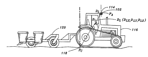
As shown in FIG. 3, the global positioning system receiver assembly 102 of the
navigation system 100 illustrated in FIG. 1, includes a global positioning
system antenna
114 mounted to the ground vehicle 116 at a point (PA) that provides a clear
view of the
sky, and thus the global positioning system- satellites of the global
positioning system
employed: The point (PA) where the global positioning system antenna 114 is
mounted is
separated from the desired control point (P~) of the ground vehicle 116 and
towed
implement 120 (e.g., a point on the ground 118 beneath the ground vehicle 116)
by a
distance, commonly referred to in the art as lever arm (D~) having a generally
vertical
lever arm component DLZ and generally horizontal lever arm components DLX and
DLy.
Consequently, the navigation system 100, illustrated in FIG. l, provides
highly accurate
navigation and or steering of the ground vehicle 116 over generally level
terrain since the
horizontal and vertical lever arm components DLX, DLy and DLZ remain
relatively
constant. However, when traversing non-level terrain (e.g., terrain having a
slope, hills,
valleys, ruts, bumps, or the like), the horizontal and vertical lever arm
components DLX,
DLy and DLZ vary with respect to one another as the ground vehicle 116 rolls
and yaws.
Consequently, the global positioning system determined position and course of
the
ground vehicle 116 may be incorrect, resulting in cross-track (DoT) errors as
shown in
FIG. 4 and/or heading or course errors (E~), as shown in FIG. 5.
To compensate for these errors, and thus allow the ground vehicle 116 to be
steered more accurately over non-level terrain, the present invention employs
an inertial
compensation assembly 122 that is inserted between the global positioning
system
receiver assembly 102 and the navigation control system 104 as shown in FIG.
2. The
inertial compensation assembly 122 dynamically measures roll and yaw of the
ground
AMS 16132 9
CA 02466691 2004-05-07
i
vehicle 116 (FIGS. 3, 4, and S) to compensate for errors in the position and
course
information provided by the global positioning system receiver assembly 102 as
the
ground vehicle 116 traverses non-level terrain. In the embodiment illustrated
in FIG. 2,
the inertial compensation assembly 122 communicates with the global
positioning system
receiver assembly 102 through a dedicated, private bus 124. The inertial
compensation
assembly 122 strips the position (e.g., latitude and longitude) and course
information .
from the navigation information generated by the global positioning system
receiver
assembly 102 and replaces this information with corrected position (e.g.,
latitude and
longitude) and course information that is compensated for errors induced by
vehicle roll
and yaw {e.g., due to side-slopes, hills, etc.) before sending the information
to the
navigation system 104 via the system bus 126. The inertial compensation
assembly 104
passes all other information provided by the global positioning system
receiver (e.g.,
speed, time, and the like) between the private bus 124 and the system bus 126
without
modification. Further, because pass-to-pass distance for an implement may
change as a
function of grade, the inertial compensation assembly 122 may generate slope
measurements, which are passed to the navigation system 104 via the system bus
124
with the corrected position and course information. In this manner, slope-
compensated
pass-to-pass track widths may be determined for the ground vehicle 116 or the
implement .
120 towed by the ground vehicle 116.
In exemplary embodiments, the inertially compensated navigation information
provided by the inertial compensation assembly 122 is identical in format to
uncompensated navigation information provided by the global positioning system
receiver assembly 102. Thus, the inertially compensated navigation information
comprising the inertially compensated position and course information from the
inertial
compensation assembly 122, along with uncompensated information such as speed,
time,
and the like, provided by the global positioning system receiver assembly 102
and passed
to the system bus 124 by the inertial compensation assembly 122 may be
utilized by the
navigation control system 104 without additional modification or formatting to
provide
navigation information to the operator, and, optionally, to steer the ground
vehicle 116
without modification of the information. In this manner, the inertial
compensation
AMS 16132 10
CA 02466691 2004-05-07
assembly T22 may be added to the navigation system 100 to provide inertial
augmentation of global positioning system based navigation information used by
the
system, without modification of existing components of the navigation system
100 such
as the global positioning system receiver assembly 102 and navigation control
system
104.
Referring now to FIG. 6, the inertial compensation assembly 122 of the
navigation system 100 shown in FIG. 2 is described. The inertial compensation
assembly
122 comprises a yaw gyroscope assembly 128 for measuring the yaw angle of the
ground
vehicle 116 (FIG. 3), an accelerometer assembly 130 for measuring the roll
angle of the
ground vehicle 116 as the ground vehicle 116 traverses non-level terrain, and
a
processing -system 132 coupled to the gyroscope assembly 128 and accelerometer
assembly 130 for determining position and course information for the ground
vehicle
116. As shown in FIG. 6, the processing system 132 may, in one embodiment,
include a
processor 134 for performing position and course calculations, controlling
communication with other components of the navigation system 100 (FIGS. l and
2),
performing fault diagnosis, and the like, and memory such as EEPROM
(electrically
erasable programmable read-only memory) 136, Flash memory 138 and RAM (random
access memory) 140 for storing software and/or firmware for the processing
system 132,
and parameters utilized by the processing system for calculating the corrected
position
and course.
In exemplary embodiments of the invention, the yaw gyroscope assembly 128
comprises a gyroscope that measures the yaw rate of the ground vehicle (e.g.,
ground
vehicle 116 of FIG. 3). The processing system 132 utilizes the measured yaw
rate to
determine a true vehicle course (i.e., gyroscopic course), compensating for
errors in the
global positioning system course induced by vehicle roll and yaw. The global
positioning
system course provided by the global positioning system receiver assembly 102
is
utilized to limit gyroscope drift. The global positioning system course may
also be used
to calibrate the bias and scale factor of the gyroscope during operation of
the inertial
compensation assembly 122. Further, because the gyroscopic course effectively
provides
AMS 16132 11
CA 02466691 2004-05-07
a course measurement as observed at the vehicle pivot point (e.g., a rear axle
of a tractor,
or the like), the gyroscopic course is projected to the point on the ground
vehicle 116
where the global positioning system receiver antenna 114 is physically located
(e.g.,
point (PA) of the ground vehicle 116 shown in FIG. 3) to provide a corrected
course that
is consistent with the course stripped from the navigation information
provided by the
global positioning system receiver assembly 102. The corrected course is then
provided
to the navigation control system 104 via the system bus 126.
In accordance with the present invention, the processing system 132 of the
inertial compensation assembly 122 determines the corrected course using the
equation:
CC -. ~GR~MEAS~ '+ ~(~-GPS - CG) °--KCICFR~ ~ Pf EQN. I
where C~ is the corrected course; GR is the yaw rate; FMEAS is the frequency
of
measurement of the yaw rate by the gyroscope assembly; CGPS is the course from
the
navigation information generated by the global positioning system receiver
assembly; CG
is the gyroscopic course; CFR is a course filter resolution variable; Kc is a
variable filter
value wherein CFR > Kc > some positive minimum value; and Pf is the value
projecting
the corrected course from a pivot point of the ground vehicle 1 I6 to a point;
where the
global positioning system receiver assembly is mounted to the ground vehicle l
16.
As can be seen from. review of EQN. 1, with reference to FIG. 5, the
gyroscopic
course CG measured by the gyroscope assembly takes precedence over the global
positioning system course CGPS over time. For large discrepancies between the
global
positioning system course CGPS and the gyroscopic course CG, the filter
variable Kc is set
to the course filter resolution CFR, resetting the gyroscopic course CG to the
current
global positioning system course CGPS. Thereafter, the value of the filter
variable Kc is
reduced over time to a minimum value, giving the gyroscopic course CG
precedence over
the global positioning system course CGPS. Preferably, the filter variable Kc
has a non-
zero minimum value so that at least a portion of the global positioning system
course
CGPS, which by the inertial compensation assembly 122 as a reference, is
weighted into
the calculation of the corrected course CC. Additionally, the gain and zero
yaw rate scale
AMS 16132 12
CA 02466691 2004-05-07
factors may be adjusted under the appropriate conditions to compensate for
drift of the
gyroscope.
Refernng again to FIG. 6, the accelerometer assembly 130 comprises an
accelerometer for measuring lateral acceleration of the ground vehicle (e.g.,
ground
vehicle 116 of FIG. 3). In accordance with the present invention, the
accelerometer
assembly 130 measures no lateral acceleration when the ground vehicle 116 is
level (i.e.,
as the ground vehicle 116 traverses substantially level terrain). However, as
the ground
vehicle 116 traverses non-level terrain, lateral tilt of the accelerometer
assembly 132 due
to roll of the ground vehicle 116 causes the accelerometer assembly 130 to
measure a
positive or negative component of acceleration with respect to gravity.
The processing system 132 uses the lateral acceleration measured by the
accelerometer assembly 130 to calculate an off track distance (DoT) for the
ground
vehicle 116, which comprises an inertially calculated estimate of the lateral.
distance
between the global positioning system determined position (PGrs) and the
actual position
of a desired control point for the ground vehicle 116, typically a point
projected to the
ground below the global positioning system receiver antenna 116 (i.e., point
(PC) in FIG.
3 and 4). The off track distance DoT may thus be determined as the height of
the
accelerometer assembly 130 above the control point (Pc) (or, alternately, the
height of the
inertial compensation assembly 122 above the control point (P~), if the
inertial
compensation assembly comprises a single unit containing the accelerometer
assembly
130) multiplied by the sine of the angle of lateral tilt of the ground vehicle
116. The off
track distance (DoT) may then be used to correct the global positioning system
determined position (PGPS) to provide a corrected position for the ground
vehicle 116,
compensated for lever arm D~, which more closely approximates the actual
position of
the ground vehicle 116.
In calculating corrected position, the processing system 132 may also
compensate
for centrifugal (high speed) accelerations incurred during turns of the ground
vehicle 116.
This compensation is accomplished, in one exemplary embodiment of the
invention, by
dynamically comparing changes in the position of the ground vehicle 116 with
respect to
AMS 16132 13
CA 02466691 2004-05-07
the course of the ground vehicle 116. Therefore, the off track distance (DoT)
may be
determined as the sum of the distance due to slope acceleration and the
distance due to
high speed acceleration, where the slope acceleration is equal to the lateral
acceleration
measured by the accelerometer assembly 130 less any radial acceleration and
high speed
roll acceleration of the ground vehicle I 16. However, the sine of the angle
of tilt of the
ground vehicle 116 is equal to the lateral acceleration determined by the
accelerometer
assembly (A) divided by the acceleration of gravity (g}. Consequently, the
distance due
to slope acceleration is the height of the accelerometer assembly (HA) added
to the lateral
acceleration determined by the accelerometer assembly (A} divided by the
acceleration of
gravity (g).
Accordingly, the processing system 132 may calculate the off track distance
DoT
for the ground vehicle 1 I 6 using the equation:
DoT ' (Ha' Wig} + DHSS. EQN. 2
where DoT is the off track distance of the ground vehicle 116; HA is the
height of the
accelerometer assembly above a desired control point such as the ground (e.g.,
point
(PC)); A is the lateral acceleration determined by the accelerometer assembly
130; g is the
acceleration due to gravity; and D~SA is the distance due to centrifugal (high
speed)
acceleration measured, in exemplary embodiments of the invention, by
dynamically
comparing changes in the position of the ground vehicle 116 with respect to
the course of
the ground vehicle 116. Preferably, once calculated the off track distance
IDoT is divided
into latitude and longitude components and added to the global positioning
system
position, which is likewise measured in latitude and longitude, to provide a
corrected
position (i.e., latitude and longitude) for the ground vehicle I I6.
In agricultural applications where the ground vehicle 116 is associated with
an
implement for depositing material such as seed, fertilizer, pesticide,
herbicide, or the like,
to the surface of a field (e.g., the ground vehicle I16 tows the implement 120
or,
alternatively, the implement is mounted to the ground vehicle 116), the pass-
to-pass track
width for the implement may vary as a function of the grade or slope of the
terrain due to
AMS 16132 . I4
CA 02466691 2004-05-07
the pull of gravity on the material deposited (e.g., dropped, sprayed, or the
like).
Consequently, as the ground vehicle 116 is steered along parallel tracks over
non-level
terrain having a lateral slope with respect to the implement, overlapping of
tangential
tracks may occur if the track width selected is too wide. 'This overlap
results in uneven
application of the material being deposited, wasting material and possibly
reducing the
yield from the field if the track width is not adjusted accordingly.
In exemplary embodiments of the invention, the lateral acceleration measured
by
the accelerometer assembly 130 may also be used by the processing system 132
to
determine the roll angle of the ground vehicle 116, from which the slope (S)
of the terrain
being traversed by the ground vehicle 116 may be ascertained. The slope (S)
may then
be used by the navigation control-system 104 to determine the effective track
width or
spacing of the implement 120. In this manner, slope-compensated pass-to-pass
track
widths may be determined for the implement 120 in real time, and may be
adjusted as the
slope of the terrain being traversed by the ground vehicle 116 increases or
decreases.
FIGS. 7 and 8 illustrate the effect of the slope (S) of the terrain traversed
by an
exemplary ground vehicle I16 on the effective track width (E) for an implement
120
towed by the ground vehicle 116. As shown in FIG. 7, the effective track width
(E)
decreases as the lateral slope or grade of terrain traversed by the ground
vehicle I I6
increases. Thus, the effective track width (E~) of a track followed by the
ground vehicle
I 16 when traversing terrain having a lateral slope will be greater than the
effective track
width (E2) of a track followed by the ground vehicle 116 traversing terrain
having little or
no slope. Thus, as shown in FIG. 8, the effective track width (E) for an
implement for a
given slope (S) is related to the track width of the implement on level
terrain by the
equation:
E = I ~ cos(S) EQN. 3
where E is the effective track width, I is the track width of the implement on
level terrain,
and S is the slope.
AMS 16132 . 15
CA 02466691 2004-05-07
In exemplary embodiments, the inertial compensation assembly 122 may be
calibrated prior to use or during use to improve the accuracy of the corrected
position and '
course determination. For example, the accelerometer assembly 130 may include
one or
more temperature sensors for measuring the temperature of the accelerometer,
thereby
allowing the processing system 132 to compensate for variations in the lateral
acceleration measured by the accelerometer assembly 130 due to temperature-
induced
accelerometer offset error and sensitivity error. To calibrate the
accelerometer
temperature response, the inertial compensation assembly 122 may be calibrated
under
known conditions (e.g., at the time of manufacture) to correlate the output of
the
temperature sensor with respect to the actual ambient temperature, and to
characterize the
offset error over a temperature range. The processing system 132 may store the
calibration data in memory (e.g., flash memory 138) to be used for correcting
roll angle
measurements for changes in the accelerometer temperature.
The inertial compensation assembly 122 may further be calibrated to identify
the
zero degree (0°) roll angle of the ground vehicle 116. This calibration
may be performed
each time the internal compensation assembly 122 is installed within the
navigation
system 100 of a ground vehicle 116. The operator of the ground vehicle 116 may
accomplish this calibration, manually, by positioning the ground vehicle 116
in a
stationary, level position and identifying to the processing system 132 of the
inertial
compensation assembly 122 that the ground vehicle 116 is stationary and level
(e.g.,
through controls provided by the navigation control system 104). Alternately,
the
operator may calibrate the zero degree (0°) roll angle by driving the
ground vehicle 116
back and forth along a straight path, thereby allowing the inertial
compensation assembly
122 to determine the zero degree (0°) roll angle by comparing the roll
angle
measurements of the ground vehicle 116 at various points along the path
traversed.
Because the inertial compensation assembly 122 does not itself generate
position
and course information, but instead employs inertial measurements to augment
position
and course information furnished by the global positioning system receiver
assembly 102,
the gyroscope assembly 128 and accelerometer assembly 130 need comprise only a
single
AMS 16132 16
CA 02466691 2004-05-07
D
accelerometer for measuring lateral acceleration of the ground vehicle 116 and
a single
yaw gyroscope for measuring yaw rate of the ground vehicle 11 b, respectively.
.
Consequently, the inertial compensation assembly 122 of the present invention
does not
require a fall suite of gyroscopes and accelerometers typically required by
prior inertial
measurement systems. Accordingly, the inertial compensation assembly 122 is
simpler,
contains fewer components, and is less costly to manufacture than such
systems.
However, it will be appreciated that the inertial compensation assembly 122
may
comprise additional gyroscopes for redundancy, to provide increased precision
of the yaw
rate and lateral acceleration measurements. Such modification of the inertial
compensation assembly 122 would not depart from the scope and intent of the
present .
invention.
Refernng now to FIG. 9, an exemplary method 200 is described for augmenting
global positioning system based position and course information utilized by a
navigation
system in a ground vehicle, wherein the position and course information is
inertially
compensated for roll and yaw of the ground vehicle as the ground vehicle
traverses non-
level terrain. As shown in FIG. 9, global positioning system positioning
signals are
received from a global positioning system at step 202, and used for generating
global
positioning system based navigation information including position (e.g.,
latitude and
longitude), course or heading, speed, time, and the like, at step 204. The yaw
rate and
lateral acceleration of the ground vehicle are also measured, at step 206,
using a
gyroscope assembly and an accelerometer assembly, respectively. A corrected
position
and course compensated for roll and yaw of the ground vehicle as the ground
vehicle
traverses non-level terrain may then be calculated for the ground vehicle, at
step 208,
using global positioning system based position and course from the generated
navigation
information and the measured yaw rate and Lateral acceleration of the ground
vehicle.
For example, in exemplary embodiments of the invention, the corrected course
may be
calculated using EQN. 1, discussed in the description of FIG. 6, while the
corrected
position may be determined by calculating an off track distance fox the ground
vehicle
using EQN. 2, also discussed in the description of FIG. 6, where the off track
distance is .
split into latitude and longitude components and added to the global
positioning system
AMS 16132 . 17
? ~ i
CA 02466691 2004-05-07
based position (latitude and longitude). The position and course is then
stripped from the
global positioning system based navigation information generated at step 204
and
replaced, ,at step 210, with the corrected position and course calculated at
step 208, for
providing corrected navigation information for the ground vehicle. In
exemplary
embodiments of the invention, the corrected navigation information may then be
used far
navigating and/or steering the ground vehicle, at step 212.
As shown in FIG. 9, the lateral acceleration measured by the accelerometer
assembly at step 206 may further be used to determine the roll angle of the
ground
vehicle 116, from which, the slope (S) of the terrain being traversed by the
ground
vehicle 116 may be determined, at step 214. The slope (S) may then be used by
the
- -navigation control system 104 to determine the effective track width or
spacing of an
implement towed by the ground vehicle at step 216. The effective track width
determined at step 216 may then be used to aid in navigating or steering the
ground
vehicle at step 212 where parallel steering or automatic steering of the
ground vehicle is
provided. In this manner, slope-compensated pass-to-pass track widths may be
determined for the implement in real time, and may be adjusted as the slope of
the terrain
being traversed by the ground vehicle increases or decreases.
In exemplary embodiments, the methods disclosed may be implemented as sets of
instructions comprising software or firmware readable by the processing system
132 of
the inertial compensation assembly 122, the global positioning system receiver
assembly
102, or components of the navigation control system 104. Further, it is
understood that
the specific order or hierarchy of steps in the methods disclosed are examples
of
exemplary approaches. Based upon design preferences, it is understood that the
specific
order or hierarchy of steps in the method can be rearranged while remaining
within the
scope of the present invention. The accompanying method claims present
elements of the
various steps in a sample order, and axe not meant to be limited to the
specific order or
hierarchy presented.
It is believed that the present invention and many of its attendant advantages
will
be understood by the forgoing description. It is also believed that it will be
apparent that
AMS 16132 . 18
CA 02466691 2004-05-07
1 < w
various changes may be made in the form, construction and arrangement of the
components thereof without departing from the scope and spirit of the
invention or
without sacrificing all of its material advantages. The form herein before
described being .
merely an explanatory embodiment thereof, It is the intention of the following
claims to
encompass and include such changes.
AMS 16132 , 19