Note: Descriptions are shown in the official language in which they were submitted.
CA 02472508 2004-06-25
VEHICLE NAVIGATION SYSTEM
FIELD OF THE INVENTION
The present invention relates to a vehicle navigation system. Specifically,
the
present invention relates to a vehicle navigation system which receives radio
waves from satellites and recognizes a current position of a vehicle having
the
navigation system mounted thereon.
BACKGROUND OF THE INVENTION
A GPS navigation system utilizing an artificial satellite has hitherto been
used as
a navigation system for various mobile bodies such as automobiles, airplanes,
and ships. A GPS receiver used in this GPS navigation system is configured to
receive radio waves from a plurality of GPS satellites, measure a receiving
point
from data of a pseudorange between each of the GPS satellites and the
receiving
point and a position data of each GPS satellite, and output GPS positioning
data.
Herein, the pseudorange contains a time offset of the receiver. However, the
GPS positioning accuracy includes error components because of the following
reasons:
(1) The accuracy is reduced because of an error occurring while radio waves
pass
through the ionosphere.
(2) The accuracy is reduced because of a multipath phenomenon in which signal
radio waves from the satellites are mixed with components of signals reflected
from the ground, buildings, mountains, and the like. The accuracy changes with
time as the state of such obstacles changes with time.
WH-12393/cs
CA 02472508 2004-06-25
-2-
Therefore, a simple navigation system with no autonomous navigation unit
mounted thereon includes a technical problem that a pointer on a screen
indicating a current position of a vehicle having the navigation system
mounted
thereon moves while the vehicle is stopped. FIG. 8 is a view showing temporal
transition of the current position obtained by GPS positioning calculation
while
the vehicle is stopped.
For such a technical problem, the Japanese Patent Laid-Open publication No. 63-
238479 discloses a technique preventing the indicator of the current position
from moving while the vehicle is stopped. In this technique, current position
information obtained by GPS positioning means is ignored when vehicle stop
detecting means detects that the vehicle is stopped.
SUMMARY OF THE INVENTION
The aforementioned disadvantage due to the GPS positioning error can occur
while the vehicle is traveling at low speed in a traffic jam or the like as
well as
while the vehicle is stopped. Therefore, if the current position information
is
ignored only when it is detected that the vehicle is stopped, wrong position
information is displayed while the vehicle is traveling at low speed.
If the aforementioned conventional technique is not only applied to the time
when the vehicle is stopped but also extended to the time when the vehicle is
traveling at low speed, there is a technical problem that the last determined
current position greatly differs from the actual current position if the
vehicle
continues to travel at low speed.
An object of the present invention is to solve the aforementioned problems of
the conventional art and to provide a vehicle navigation system which can
accurately recognize the position and the target direction of a vehicle having
the
navigation system mounted thereon even while the vehicle is stopped or
traveling at low speed.
In order to achieve the aforementioned object, the present invention is a
vehicle
navigation system executing GPS positioning calculation based on radio waves
transmitted from a plurality of GPS satellites to obtain a current position
based
on positioning data. The vehicle navigation system is characterized by
including: a unit sensing a traveling state of a vehicle; a unit judging based
on a
WH-12393/cs
CA 02472508 2004-06-25
-3-
result of the sensing whether a travel speed of the vehicle is less than a
reference
speed; a unit smoothing GPS positioning data when the travel speed is judged
to
be less than the reference speed; and a unit calculating current position
based o n
the smoothed GPS positioning data.
According to the aforementioned aspect, while the vehicle is stopped or
traveling at low speed, at the time when errors of the GPS positioning data
greatly affect on display of the current position, the GPS positioning data is
smoothed, and error components are canceled with each other or compensated.
Therefore, the current position can be accurately recognized.
Moreover, the current position can be recognized by executing the GPS
positioning calculation even when the vehicle is traveling at low speed.
Accordingly, guidance is possible even when the vehicle is forced to travel at
low
speed at the time of being stuck in a traffic jam or the like.
BRIEF DESCRIPTION OF THE DRAWINGS
Preferred embodiments of the invention are shown in the drawings, wherein:
FIG. 1 is a perspective view showing a saddle-type buggy for rough terrain on
which a vehicle navigation system of the present invention is mounted.
FIG. 2 is a block diagram showing a configuration of a main portion of the
vehicle navigation system according to the present invention.
FIG. 3 is a view schematically expressing storage contents of a WP memory.
FIG. 4 is a view showing a display example (NAVI mode) of a display panel.
FIG. 5 is a view showing a display example (NAVI mode) of the display panel.
FIG. 6 is a view showing a state where the display examples of the display
panel
change in response to operations of a MODE switch.
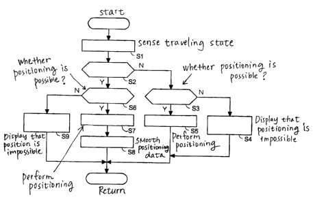
FIG. 7 is a flowchart showing an operation of the embodiment.
WH-12393/cs
CA 02472508 2004-06-25
-4-
FIG. 8 is a view showing temporal transition of a current position obtained by
GPS positioning calculation while a vehicle is stopped.
DETAILED DESCRIPTION OF THE PREFERRED EMBODIMENTS
Hereinafter, a description will be given of an embodiment of the present
invention in detail with reference to the drawings. FIG. 1 is a perspective
view
showing a saddle type buggy 100 for rough terrain on which a vehicle
navigation
system of the present invention is mounted. Same reference numerals as those
described above denote the same or similar members.
The ATV of the present invention offers hill-climbing ability and off-road
ability
by using large-diameter wheels 101, an under cover 102, a four-wheel drive
mechanism, and the like. A meter unit 107 is provided in the center of a
handle
106, and a helical-type or patch-type GPS receiver antenna 103 stands toward
the
sky on the upper part of the meter unit 107. The saddle-type buggy 100 is
frequently used in rough terrain where the attitude of a traveling vehicle
largely
changes, but GPS radio waves can be well received irrespective of the changes
i n
the attitude by employing a helical antenna with low directivity as the
receiver
antenna 103.
FIG. 2 is a block diagram showing a configuration of a main portion of a
navigation system 1 mounted on the buggy 100. The navigation system is a
simple type which does not include an autonomous navigation system mounted
thereon and calculates the current position based on GPS positioning data.
A GPS receiver 2 periodically receives GPS signals transmitted from a
plurality of
artificial satellites. A vehicle speed sensor 3 senses a travel speed of the
vehicle
with the navigation system 1 mounted thereon based on revolutions of the
wheels. The GPS receiver 2 and the vehicle speed sensor 3 are connected to a
system bus 13 with a serial interface 11 interposed therebetween.
A CPU 10 calculates the current position (latitude and longitude) of the
vehicle
with the navigation system mounted thereon and the current time based on a
plurality of GPS signals received by the GPS receiver 2 and senses the travel
direction based on a history of the current position and the information
acquired
from the vehicle speed sensor 3. The CPU 10 further calculates relative
positional relationship between a way point (WP) which is already registered
in a
W H-12393 / cs
CA 02472508 2004-06-25
-5-
way point (WP) memory 12 and its own current position. A RAM 17 offers a
work area for the CPU 10.
A display control circuit 19 outputs the direction and the distance of the W P
from the current position and the like to a display panel 6 of the meter unit
107.
Switches 65, 66, 67a, and 67b of the display panel 6 are individually
connected to
the system bus 13 with a parallel interface 15 interposed therebetween.
FIG. 3 is a view schematically expressing storage contents of the WP memory
12.
Storage areas are reserved for respective WP numbers, which are information
identifying WPs, and each of the storage areas stores the latitude and
longitude of
each WP as positional information of the WP.
FIGS. 4 and 5 are views showing display examples of the display panel 6. Same
reference numerals as those described above denote the same or similar
members.
The navigation system of the embodiment is provided with a "NAVI mode"
indicating the direction of a WP or the final destination in each of 16
directions
and a "compass mode" indicating the travel direction in each of eight
directions.
In the NAVI mode, as shown in FIG. 4, a vehicle speed display area 61, a
positioning state display area 62, and a direction display area 64 are
displayed. In
the positioning state display area 62, a GPS positioning state is displayed.
In the
direction display area 64, the direction of a WP or the final destination is
indicated by an arrow in each of 16 directions. A number of a WP currently
selected and a distance to the WP are displayed in a multi-display area 63.
In the compass mode, as shown in FIG. 5, the vehicle speed display area 61,
the
positioning state display area 62 where the GPS positioning state is
displayed, and
a compass display area 68 are displayed. In the compass display area 68, a
current
travel direction is indicated by each of eight directions (north [N],
northeast [NE],
east [E], southeast [SE], south [S], southwest [SW, west [W], northwest [NW]).
In
the multi-display area 63, an odometer (ODO), a tripmeter (TRIP), elapsed time
(HOUR), and the current time are selectively displayed.
WH-12393/cs
CA 02472508 2004-06-25
-6-
FIG. 6 is a view showing a state where the display examples of the display
panel 6
change in response to operations of the MODE switch 65. For example, when the
MODE switch 65 is operated in a state of the compass mode where the ODO is
displayed, only the display in the multi-display area 63 is sequentially
changed to
TRIP display, to HOUR display, and to clock display while being in the compass
mode. When the MODE switch 65 is further operated, the compass mode is
changed to the NAVI mode. When the MODE switch 65 is operated in the
NAVI mode, the display is returned to the ODO display state of the compass
mode.
FIG. 7 is a flowchart showing a procedure to recognize the current position in
the
embodiment, mainly showing a procedure of a process which the CPU 10
executes according to a control program stored in the ROM 16.
In step S1, the traveling state of the vehicle is sensed based on a pulse
signal
detected by the vehicle speed sensor 3. In step S2, it is judged based on the
sensed
traveling state whether the travel speed V of the vehicle is less than a
reference
speed Vref. When the travel speed V is not less than the reference speed Vref,
the procedure proceeds to step S3, and it is judged whether positioning based
on
the GPS signals is possible. When the vehicle is traveling in a tunnel or in a
mountainous area and cannot receive any GPS signals, the procedure proceeds to
step S4. In the step S4, a sign indicating that positioning is impossible is
displayed in the positioning state display area 62. On the contrary, when it
is
judged that the positioning is possible in the step S3, the procedure proceeds
to
step S5, and the current position is determined based on the GPS signals. The
obtained positioning data is used to calculate the travel direction in the
compass
mode and used to display the direction of the destination with an arrow in the
NAVI mode.
On the contrary, when the travel speed V is judged to be less than the
reference
speed Vref in the step S2, the procedure proceeds to step S6, and it is judged
whether positioning based on the GPS signals is possible in the same manner as
the step S3. When the positioning is impossible, the procedure proceeds to
step
S9, and the sign indicating the state where the positioning is impossible is
displayed in the positioning state display area 62 like in the step S4.
W H-12393 / cs
CA 02472508 2004-06-25
On the contrary, when it is judged in the step S6 that the positioning is
possible,
the procedure proceeds to step S7, and the current position is determined
based
on the GPS signals. In step S8, the positioning data is filtered, and a
smoothing
process is then executed to reduce effects of variation in the filtered
positioning
data. In the embodiment, an average value of positioning data P obtained i n
previous positioning operations and current positioning data PO is calculated
as
new positioning data. At this time, it is possible to employ weighted average
with which priority is given to the previous positioning data P or to the
current
positioning data PO vice versa.
As described above, according to the embodiment, if the travel speed V is less
than the reference speed Vref as in the case where the vehicle is stopped or
traveling at low speed, the current position is calculated based on the
positioning
data for the positioning operation more than once without employing the
current positioning data PO as it is. Accordingly, the current position can be
comparatively accurately calculated even if the positioning data contains an
error. Therefore, in the compass mode, the display of the travel direction can
be
prevented from changing while the vehicle is stopped. In the NAVI mode, the
display of the destination direction can be prevented from changing while the
vehicle is stopped.
Furthermore, according to the embodiment, the current position can be
recognized by executing the GPS positioning calculation even while the vehicle
is traveling at low speed. Accordingly, guidance is possible even when the
vehicle is forced to travel at low speed at the time of being stuck in a
traffic j a m
or the like.
According to the present invention, the following effects can be achieved.
(1) The GPS positioning data is smoothed so that error components are canceled
with each other or compensated while the vehicle is stopped or traveling at
low
speed, at the time when the errors of the GPS positioning data greatly affect
o n
the display of the current position. Accordingly, the current position can be
accurately recognized.
(2) The current position can be recognized by executing the GPS positioning
calculation even when the vehicle is traveling at low speed. Accordingly,
W H-12393 / cs
CA 02472508 2004-06-25
8
guidance is possible even when the vehicle is forced to travel at low speed at
the
time of being stuck in a traffic jam or the like.
Although various preferred embodiments of the present invention have been
described herein in detail, it will be appreciated by those skilled in the
art, that
variations may be made thereto without departing from the spirit of the
invention or the scope of the appended claims.
WH-12393/cs