Note: Descriptions are shown in the official language in which they were submitted.
CA 02479282 2013-09-13
1
A METHOD AND SYSTEM FOR DETERMINING A TRACK RECORD OF A MOVING
OBJECT
Field of the invention
The present invention relates to a method and system for determining a track
record of a
moving object by determining at least one characteristic property of the
object.
Background
Today, we are facing a global problem, which increases every year. This is the
heavy
traffic, including car traffic, air traffic and traffic at sea. The result is
a huge increase in
accidents every day leaving thousands of people injured or killed all over the
world. In
addition to affecting peoples health and lives, these accidents also involve a
huge cost for
the society. Accidents, on land, in air or at sea, may be related to many
different reasons.
In the western world, the statistics tells that the group that causes the most
car accidents
are young people around the age of 17-20 years old and professions such as
food
deliveries. Besides this, dangerous roads, sailing routs and frequently
turbulent air spaces
are areas of focus, when looking at statistics of accidents. By monitoring
these risk groups
or areas, the accident frequency may be reduced, as well the cost that follows
the
accidents.
Another important application is by creating an additional "Black box" for
aircrafts, being a
data storing and reporter means to monitor repeatedly the exact position of
the aircraft in
a more detailed way than it is done today. If an aircraft is outside its
predefined route, a
warning could be sent to the air-traffic control. The warning signal could
also comprise
unusual flying behaviour. In today's systems the communication to the air-
traffic control
can be disconnected within the aircraft. This is a possible scenario, where an
airplane is
hijacked. In such cases it is impossible to monitor the trajectory of the
aircraft. Accordingly
by implementing such a data storing and reporter means in the fin or the tail
of the aircraft
as an example, the connection to the air traffic control cannot be
interrupted.
CA 02479282 2013-09-13
2
It is apparent that there is a need for device, a data storing and reporter
means, for
obtaining a track record of a moving object.
In US 5,805,079 a system and method is presented for monitoring movements and
performance of a motor vehicle, in order to locate it and determine the manner
in which it
is driven. This is solved by evaluating and recording the driving method over
a period of
time. One of the variables that is monitored is the acceleration or
deceleration of the
vehicle, determined by a sensing module. From the acceleration the location,
the speed
and direction of travel is calculated. It is however mentioned that the
position of the
vehicle may be determined from the Global-positioning-system (GPS). The
operation of
the system is controlled with a microprocessor, wherein a separate performance
analysing
computer with a fuzzy logic circuitry and a neural network circuit is provided
to process
data collected from the sensing device to analyse how the vehicle is driven.
Another invention is described in the US5,919,239-A patent, where a GPC
receiver
obtains GPS signals and automatically or manually stores information such as
position
and time of position. The system in this invention sends information from
system/device
to computer in a control unit where a track record can be created. A similar
device has
been described for airplanes in JP 10035593. A tracking recorder for three-
dimensional
positioning utilises GPS coordinates and calculates from these coordinates
variables such
as latitude, longitude and altitude. This information can be used afterwards
to show the
flight route.
US 2002/029109 Al discloses a system for recording positional and operational
data of a
vehicle including a GPS receiver and a storage means for GPS data. The stored
data
may comprise parameters such as velocity and distance travelled, as well as
supervision
of a moving object with regard to a three-dimensional frame set.
The problem with the above systems is how complicated they are and the lack of
real time
processing and communication of collected and calculated data obtained and
processed
by these systems. For example, these systems do not utilize the GPS
coordinates in order
CA 02479282 2013-09-13
3
to determine variables such as the acceleration and the perpendicular
acceleration, which
is important for determining in which manner a moving object is steered and
how
accurately it maintains it's route.
Summary
It is an object of the present invention to provide a simple method and a low
cost and
compact system for obtaining a track record of a moving object, and thereby
reducing
accident rate. It is a further object of the present invention to provide a
method and a
system for utilization as a data collection, processing and a reporter system
for moving
objects such as aircrafts and ships. This system uses GPS coordinates and real
time
processing of for monitoring and reporting the objects position as well as
other physical
parameters, such as speed, acceleration and centripetal acceleration of the
moving
object.
Certain exemplary embodiments can provide a method for determining a track
record of a
moving object by determining at least one characteristic properties of the
object, said
method comprising: receiving at least three Global-Positioning-System (GPS)
coordinates,
each of the coordinates comprising the current position of the moving object
and the
current time, at which the moving object is at the current position, storing
said coordinates
data in a storage means, utilizing the at least three coordinates for
determining said
plurality of characteristic properties by using perpendicular acceleration of
the moving
object, and thereby obtaining a track record for the moving object, wherein
the track
record comprises information related to: direction of movement, velocity, and
wherein said
track record data is utilized to create user information.
Preferably, the coordinates data are stored as at least one data package
comprising one
timestamp coordinate point as a reference point for said at least one data
package, the
timestamp giving the absolute position and absolute time of the moving object,
and a
plurality of coordinate data points as a deviation from the timestamp
coordinate point. As
an example the data package consists of 28 GPS coordinates points, including
the GPS
timestamp coordinate point. The number of data in each package is however not
essential. The timestamp point requires much space because of all the
information, i.e.
CA 02479282 2013-09-13
4
the exact location (global) and the exact time. The additional points in the
data package
use however the timestamp as a reference point, and therefore instead of
giving the exact
position and the exact time of each coordinate point, which is very space
demanding, the
deviation from the timestamp is used and stored. This minimizes the memory
required for
storing each data point. Accordingly, each data package may be regarded as one
coordinate system with the timestamp as the reference point. By using a
plurality of such
data package, and therefore defining a new timestamp point, the errors are
minimized,
due to the fact that the deviation from these reference points are being
registered and
stored, and not the absolute GPS-coordinate points.
In one embodiment the stored GPS coordinates data is transmitted to a computer
system
to a receiver side that is provided with a computer program for determining
said at least
one characteristic property of the moving object. This transmission may be a
wireless
transmission, such as through a satellite system or telephone network or the
transmission
may be through plugging the system to a computer system. In another preferred
embodiment said characteristic property of the moving object may be determined
and
optionally stored prior to transmitting the data, whether or not the data is
the GPS
coordinates or said characteristic property data or both are transmitted to a
receiver side,
wherein the transmission may be as mentioned above.
Both these embodiments depend on how compact the system is supposed to be. If
the
computer system is on the receiver side the system may be more compact, such
as in the
size range of box of matches. The coordinates data may be stored as at least
one data
package, the at least one data package comprising at least one timestamp
coordinate
point as a reference point for said at least one data package, the timestamp
giving the
absolute position and absolute time of the moving object, and a plurality of
coordinate
data points as a deviation from the timestamp coordinate point. This
methodology requires
a lot less space than conventional methods and is therefore less costly.
CA 02479282 2013-09-13
The moving object may be a motor running vehicle, wherein the at least one
characteristic
property is at least one of the following:
= the perpendicular acceleration of the moving object acent,
5 = the acceleration of the moving object a,
= the velocity of the moving object v,
= the total travelled distance of the moving object s,
= the location and a time (x,y,t), and
= the total travelling time of the moving object total.
These characteristic properties data may be determined through standard
calculations
utilizing the basic laws of physics, i.e.:
V2
acent ¨
R
Av
a = ¨,At
As
V =
At
s IAsõand
ttOtaj= E Ati,
where Av is the variation in the speed of the moving object in the time
interval At, As the
distance the moving object has travelled in the time interval At, As the
distance between
two GPS coordinates, which may be adjacent coordinates, At; the time interval
between
two GPS coordinates, which may be adjacent coordinates and V is the tangential
speed of
the moving object in a circle of radius R. The radius R may be determined by
observing
the path route of the moving object. From this path the curve is assumed as a
sector of a
circle in a first approximation, from which the radius R may be determined.
The condition
At-->0 gives the instant instantaneous velocity and acceleration.
CA 02479282 2013-09-13
6
The time interval between two received GPS-coordinates depends on the GPS
satellite
system as well as the processing speed of the system.
In a preferred embodiment of the present invention, the information may
comprise any of
the following:
- moving manner,
- velocity comparison with a velocity database,
wherein the velocity database includes information about upper and lower
velocity limits in
certain areas.
A predetermined upper- and lower limit of the at least one characteristic
property may be
defined, mainly for the track record. Thus the track record of the moving
object may be
based on the data that exceeds said predetermined limits such as the velocity
and the
acceleration, both linear and lateral acceleration (perpendicular acceleration
or centripetal
acceleration) to the direction of the moving vehicle. The track record may
also contain
information relating to position of the vehicle. These predetermined limits
may also be
used as a warning signal, indicating when the moving object is driven to fast,
when the
acceleration is to large etc.
The reading of the first GPS coordinates data may be bound to a minimum
velocity of the
object, i.e. if the object exceeds a predetermined velocity limit, which may
as an example
be 5 km/hour, the first GPS data is collected.
Calculations of other physical (dynamical) parameters, where the GPS
coordinates are
employed, are also possible.
In one embodiment means for obtaining at least one environmental parameter is
provided,
wherein each of said parameters can be associated with a GPS coordinate. These
parameters could for instance be precipitation, temperature, moisture, wind-
speed. Under
certain circumstances the at least one environmental parameter could influence
how the
CA 02479282 2013-09-13
7
upper-and lower limit of the at least one characteristics property is defined.
As an
example, if weather conditions would change resulting in icing on roads, that
information
could be stored in a database and transformed into a signal resulting in a
lowered speed
limit on the roads in a given area.
Accordingly, the track record, which may be coordinates or any of the above
mentioned
physical quantities (characteristic property) are stored and given an exact
location with a
time. The time period in which these characteristic properties were determined
may be
based on the time from starting the automobile until it is stopped. In one
embodiment the
receiving of the first GPS coordinates may be based on that the automobile is
moving and
exceeds said predetermined limits. If the automobile is under this minimum
velocity, no
data is collected and stored. If the automobile exceeds this minimum velocity
the first GPS
data is collected and the calculations of the at least one characteristic
property starts, and
stops when the velocity goes under the minimum velocity. If the amount of data
exceeds
the upper limit of the storage means, the new data may replace the oldest
data.
All these physical characteristic properties are determined by the GPS-
coordinates, with
the standard physical calculations preferably with the location of the vehicle
as well as the
time. A typical track record would therefore link the position and/or the time
and/or the at
least one characteristic property of the moving object to the position of the
vehicle/moving
object and the time.
Accordingly, a track record of the moving object for a predetermined time
limit could
comprise at least one of the following data:
- the total distance the automobile has travelled,
- the total time the automobile has been driving,
- where and/or when said predetermined limits has been exceeded,
- the maximum speed,
- the maximum acceleration,
- the position,
CA 02479282 2013-09-13
8
- the maximum brake distance, and
- the most frequent driving speed of the vehicle.
An example of an application utilizing such a track record is when parents
want to monitor
the driving habits of their child, which has just got it's driver's licence,
with the aim of
ensuring its safety.
An example of an application is the insurance companies, which could also
implement
such system into the cars for teenagers in the age of 17-20, which could
result in lowering
the insurance fee.
An example of an application is a food delivery company, such as a pizza place
that could
also integrate this into their cars, therefore enforcing their employees to
drive safely and
obey the common traffic rules. If an employee would exceed certain upper-
limits, such as
velocity upper limit or acceleration upper limit, the event would be
registered with location
and time.
An example of an application is calculation of additional taxes for diesel
automobiles, such
as jeeps, that pollute more than many other automobiles. The calculations
could be based
on the following criterion:
= urban driving, and
= rural driving.
The charging could, as an example, be lower if the automobile is driven in
rural areas than
in the city. Therefore, by keeping track of where the automobile was driven,
the charging
per kilometre could be set accordingly.
In another preferred embodiment the moving object is an aircraft, wherein the
file history
(the track record) may comprise at least one of the following:
- Whether or not the aircraft is inside recommended 3-dimensional
geo-fence,
- speed and/or variations thereof,
CA 02479282 2013-09-13
9
- linear acceleration,
- perpendicular acceleration,
- altitude and/or variations thereof, and
- position,
wherein real time processing of said data can be transformed into a signal and
obtained
by a receiver. In this case the receiver would be air-traffic controller.
The rate of collecting the GPS-coordinates and/or determining the at least one
characteristic property data of the moving object may be as an example every
0.1-2
seconds, including 0.5-1.5 seconds, including 0.8-1.2 seconds, wherein
preferably the
characteristic property data is transmitted to a receiver repeatedly. In the
case that the
moving object is an aircraft, this is of essential importance so the exact
trajectory and
orientation of the aircraft is determined frequently. The receiver would in
this particular
case by the air-traffic control.
In still another embodiment the system is provided with a means for receiving
information,
such as from air-traffic control, if the moving object is an airplane. This
information could,
as an example, be warnings. In the case the moving object is a motor running
vehicle,
these warnings could indicate when vehicle is outside the range defined by the
upper and
lower limit of the at least one characteristic property. This could, as an
example, be when
the vehicle exceeds the velocity limit. In the case the moving object is a
ship, the warning
could consist of bad weather ahead.
Certain exemplary embodiments can provide a registration system for
determining a track
record of a moving object by determining a plurality of characteristic
properties of the
object, said system comprising: means for receiving at least three Global-
Positioning-
System (GPS) coordinates, each of the coordinates comprising the current
position of the
moving object and the current time, at which the moving object is at the
current position,
storage means for storing said coordinates data, said system capable of
utilizing the at
least three coordinates for determining said plurality of characteristic
properties by using
perpendicular acceleration of the moving object, and thereby obtaining a track
record for
CA 02479282 2013-09-13
the moving object, wherein the track record comprises information related to:
direction of
movement, velocity, and wherein said track record data is utilized to create
user
information.
5 In one preferred embodiment the system further comprising a transceiver
for transmitting
data from the registration system and/or receiving data. The computer system
may be
located external from the registration system, in the case the size of the
system is to be
minimized. This would be the case if the system would be used in a motor
running vehicle,
such as a car. The powering could be through the electric system of the moving
object,
10 such as through the cigarette lighter or by providing it with a battery,
preferably
rechargeable. The data would then simply be transmitted from the system to a
computer
system, such as through a wireless network system, which may be a satellite
system
and/or telephone network and/or radio transmitting system and/or mobile
telephone
system and/or infrared data transmission, or a system based on Blue Tooth
technology
where the characteristic properties are determined.
If on the other hand the moving object is larger, the computer system could be
integrated
into the system, and not be on the receiver's side. If the moving object is an
airplane, this
system can be regarded as an additional data storage and processing means
comprising
information relating to at least one of the following data:
- keeping inside recommended 3-dimensional geo-fence,
- speed and/or variations thereof,
- linear acceleration,
- perpendicular acceleration,
- altitude and/or variations thereof, and
- position,
wherein real time processing of said data can be transformed into a signal and
obtained
by a receiver.
CA 02479282 2013-09-13
11
In another preferred embodiment the system is provided with at least one
sensor for
determining at least one environmental parameter and associated with a GPS
coordinate.
These parameters may as an example is precipitation, temperature, moisture,
wind-speed
etc.
Detailed description
In the following the present invention, and in particular preferred
embodiments thereof, will
be described in greater details in connection with the accompanying drawings
in which
Figure 1 shows an overview over the system for determining a track record of a
moving
object,
Figure 2 shows how received and calculated data is stored in the system,
Figure 3 shows a flow diagram of how the downloaded data in the system is
published
through user intervention to a map or a report, and
Figure 4 shows one embodiment of how the perpendicular acceleration may be
determined from an automobile driving in a curve.
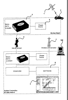
Figure 1 shows an overview over the system for determining a track record of a
moving
object, where the moving object is a car 2. In this example the car is
provided with a
registration system 3 comprising a Global-Positioning-System (GPS) with an
antenna
such as ceramic patch, passive antenna for receiving plurality of GPS
coordinates from a
satellites 1 and a storage means for storing said coordinates. These
coordinates give the
position of the car 2 as well as the time. The system may be powered by
plugging it to the
electric system of the car, i.e. the cigarette lighter. The system may also be
powered
through battery or any other kind of power source. After collecting a
plurality of GPS
coordinates, such as after one driving cycle, the coordinates are transmitted
to a receiver,
where at least one characteristic property of the car is determined.
Transmitting the
coordinates data by be done manually 5 or through wireless communication 7,
such as
through satellites system, telephone network, the Internet or by utilizing
Blue Tooth
CA 02479282 2013-09-13
12
technology. On the receiver side software 8 utilizes the coordinates for
calculating at least
one characteristic property of the car, which may be the velocity, the total
travelled
distance, the acceleration, the perpendicular acceleration and all variations
thereof. A
track record 9 of the car is obtained comprising information relating to the
driving in this
driving cycle. As an example the track record shows the total distance in the
driving cycle,
where the speed of the car exceeded a predetermined speed limit, and where
exactly
(with a street name) this event occurred, the speed of the car in a curve,
which is
determined from the perpendicular acceleration.
In another embodiment the at least one characteristic property of the system
may be
determined during or after collecting a plurality of GPS coordinates points,
so that the data
transmitted to a receiver are fully processed data. One application of this is
when
implementing the system to an airplane, where both the positioning of the
airplane as well
as other characteristic properties are monitored. The receiver, in this case
the air-traffic
control would receive information relating to if the airplane is inside
recommended 3-
dimensional geo-fence or not, the speed and/or variations thereof, the linear
acceleration,
the perpendicular acceleration altitude and/or variations thereof, and
position. Preferably,
the system would be provided with receiving means for receiving signals from,
in this
case, the air-traffic control, which could be warnings.
The essential part here is to receive GPS-coordinates points and utilize these
data points
in determining characteristic property for a moving object. The moving object
may as well
be any kind of motor vehicle, a ship etc.
Figure 2 shows how received and calculated data is stored in the system and
how the
system determines a track record of a moving object, wherein antenna 11
receive a GPS
satellite signal, giving a coordinate of a moving object. A microprocessor 12,
preferably a
SiRFStar-II chip receives the coordinate data, and stores the data in a
storage means 13,
preferably a Flash memory. A firmware 14 is also provided for controlling what
information
goes into the memory and how it is packed and organized. The firmware controls
and
constructs the data transferred to the flash memory. The data construction is
based on
CA 02479282 2013-09-13
13
data package system. Every data package comprises a number of measurements.
First
record of data in the package is a full version of the data, a Timestamp
(Timestamp ID, full
position, full date and a full time).
The rest of data package comes in sets of a predetermined number of
measurements and
every set ends with a checksum for data reliability verification. Every
measurement
comprises of a relative number from the last position and a relative number
from the
time/date in the timestamp.
As an example one data package consists of 28 data including the timestamp
data point
(x-r, y-r, try This timestamp data point is used as a reference points for the
subsequent
data points in the data package. The timestamp gives the exact position,
usually in
latitude and longitude coordinates, of the object (XT, YT) as well as an exact
date tT, i.e.
year, month, day and time. The subsequent data points in this package show the
deviation from these coordinates, i.e. (Axi, Ay, At ) where Ax, = XT¨ xi and
Ay, = yi with
xi and yi is the absolute position of later coming GPS-coordinates in the x-
and y-axis (i.e
north and south, or latitude and longitude) and At; = t-r¨ ti is the elapsed
time interval from
tr. This deviation may also be the deviation from the adjacent GPS-coordinate,
so that Ax,
= xi¨ x11 , AY, = y,¨ Yj..i At; = t,¨ ti.l.Therefore, by defining such data
package where only
the first data point, the timestamp, is used as a reference point and the
subsequent
coordinate data points in one data package are simply the deviation from this
timestamp a
space is saved, and larger number of points may be collected, than if all the
data points in
the data package would be timestamps.
Preferably, the new data package is defined regularly and therefore a new
timestamp is
defined. This is simply to maintain a high accuracy in the GPS-coordinates and
in the later
determined characteristic properties of the object. If there is an error in
the first timestamp,
it will be corrected by the next defined timestamp. Accordingly, a new
timestamp defines a
new coordinate system with a plurality of coordinates points. The system
therefore defines
regularly a new coordinate system.
CA 02479282 2013-09-13
14
The conditions that can close each timestamp could be:
= Time, each data packet has a maximum size.
= Speed of vehicle goes under predetermined limit
= N/S/E/VV indicator change (For instance N/VV to N/E)
= The GPS signal strength goes under predetermined level
The conditions that have to be met before starting to log a new data package
could be:
= Five seconds after transition from GPS signal strength below
predetermined level to above & speed is above a certain predetermined
limit
= Speed transition from under predetermined limit to above & GPS signal
strength above predetermined level
In the Timestamp ID it can be determined if the following events have occurred
since the
last measurement.
= Power loss
= GPS signal strength gone to invalid
= GPS signal strength gone below predetermined level
The interface (5) from the data storage and to the data processing system can
go trough a
wireless transmission as mentioned earlier, such as through satellite system
or telephone
network or the transmission may be through plugging the system to a computer
system
and download the data to the data processing system.
Example:
The following example illustrates one data package with a plurality of
increment packages,
wherein each increment package comprises three increment elements.
U)
a)
..o
o
(N
Timestamp
Start ID Time/Date Latitude Longitude Checksum
CA 02479282 2013-09-13
Increment Packet nr1
Inc. Latitude Inc. Longitude Milliseconds
5, _______________________________________
8 Inc. Latitude Inc. Longitude
Milliseconds
Inc. Latitude Inc. Longitude Milliseconds Checksum
Increment Packet nr2
Inc. Latitude Inc. Longitude Milliseconds
5, _______________________________________
8 Inc. Latitude Inc. Longitude
Milliseconds
Inc. Latitude Inc. Longitude Milliseconds Checksum
etc ..............
Total of 9 increment packets in 1 Data Packet
Timestamp:
The first element in the data package is the Timestamp element, comprising:
5 FDFD 13.02.2002-17:38:21:215 -64,12584
21,54871 f5h
where start ID, which is the first field in the Timestamp, tells the system
the ID type of the
Timestamp. There are numerous types of Start ID;
FDFD = When the unit comes out of a power loss.
10 FCFC = When the unit had lost signal and comes in again.
FFFF = Normal, when the unit is logging continuously without power and signal
loss.
The second field in the Timestamp is the Date and time, with milliseconds.
Latitude and
longitude position comes after that in the third and fourth field in the
Timestamp. Check-
15 sum in the fifth field in the Timestamp is used to find out weather the
Timestamp is
damaged or not and is found by summing up all the14 bytes (ignore overflow
bit) and
using XOR.
CA 02479282 2013-09-13
16
Increment elements in the first increment package, following after the
timestamp element,
reflect, as mentioned before, the changes in the latitude, longitude and time
difference
from the Timestamp value. The first and second increment elements (coordinate-
point) in
increment package nr.1 could have the following coordinates:
Increment element nr 1:
1251 349 1345
with 1251 as the latitude change from the Timestamp latitude value, 349 the
longitude
change and 1345 the time change (milliseconds), and the second increment
element the
coordinate
Increment element nr 2:
1008 142 1350
In this example every third increment element in each increment package has an
additional element, which is the check-sum that verifies that three last
increment elements
are valid, i.e.
Increment element nr 3:
1240 124 1310 5Th
with 5fh showing the checksum, and the other 1240, 124 and 1310 the change in
the
latitude, longitude and time from the Timestamp.
Accordingly each increment package with three increment elements require only
20 bytes,
versus 20 bytes for only one Timestamp coordinate point. Therefore, if each
data point in
the increment packages would be a Timestamp point instead of increment
element, each
increment package would require 3*20 bytes=60 bytes, instead of 20 bytes.
Therefore the
data capacity in the present system is enlarged.
CA 02479282 2013-09-13
17
The checksum could as well be the in the second, fourth, fifth etc. increment
element in
the increment package.
Figure 3 shows a flow diagram of how the data in the system is downloaded to a
receiver.
The raw measurement data in the device's memory is downloaded to the system
and
saved for later processing 22. In this embodiment the data decode 21 is the
part of the
system were data is decoded from a raw-data file. The decoded raw data is then
filtered
23 according to specified criteria, such as if there is an error in the
calculating a
characteristic property, such as the acceleration is too large, it will not be
shown, and it
can also happen that the same coordinate point is collected twice. In this
level all
calculations in the at least one characteristic property of the moving object
are performed
on the decoded data and filters are applied where needed. The final processed
data is
then stored in a database table 24 and is ready to be used for publishing
reports and
displaying maps. Information from this database is published 25 according to
user set
criteria 28 and displayed either on maps 27 or in reports 26. The user can, as
an
example, specify start and end time of reports, maximum or minimum of at least
one of
the moving vehicle's characteristics, the duration of a vehicle standstill and
etc.
Figure 4 shows one embodiment of how the perpendicular acceleration may be
determined from an automobile 30 driving in a curve. A plurality of GPS
coordinates points
including the timestamp 31 is shown. All subsequent GPS coordinate points are,
as
mentioned earlier, the variation from the timestamp. In this example and in a
simplified
picture assuming the coordinates are as real coordinates, the transversal (T)
speed N./1,T
and V+1,-1-of the automobile is determined through:
V i,T = I ((x(i) ¨ x(i ¨1))2 + (y(i)- y(i -1))2)
(1)
t(i)-t(i -1)
Vi +1,T = lax(i +1) ¨ x(i))2 + (y(i +1)- y(i))2)
(2)
t(i +1)¨ t(i)
CA 02479282 2013-09-13
18
where the travelled distance is the distance between two points, in this case
adjacent
points utilizing Pythagorean theorem. The radius R 38 of the curved path, is
where the
vectors ro 36 and r,+1,0 ,perpendicular to the tangent in the two points,
intersect 39. These
two vectors are given as:
ri=040-xT-x(c),y(0-yT-y(c)) and r141=(x(i+1)-xT-x(c),Y(I4-1)-YT-Y(0),
with (xc,yc) as the intersection point. Using standard vector calculations the
intersection
(xc,yc) 39 is obtained and therefore the radius R 38, from which the
perpendicular
acceleration is obtained, i.e.
acent=V2I,T/R=
Also by summing up the distance between two points, preferably adjacent
points, by using
Pythagorean theorem as shown in Eqs. (1) and (2) the total travelling distance
of the
automobile is obtained.
However in reality, the GPS coordinates are presented as latitude and
longitude
coordinates. In one preferred embodiment the GPS technology, WGS-84 (World
Geodetic
System 1984) is used. This model assumes an ellipsoid with a semi-major axis
(equatorial
radius) a = 6,378,137 m, and a semi-minor axis (polar radius) b =
6,356,752.3142 m
(defined as 1/f = 1/298.257223563, where f=(a-b)/a).
Usually, an agricultural field has relatively small size (with respect to the
Earth), and may
be considered as a flat surface at a particular location on the Earth.
Therefore, in order to
convert geographic coordinates into linear units (real coordinates) it is
necessary to define
the distance corresponding to a 10 change in longitude (F10) and latitude
(Flat) for a
specific field location (average geographic latitude 9 and height over
ellipsoid h).
CA 02479282 2013-09-13
19
These conversion factors may be determined using the relation
-
7 a2
FIon = ________________________ +h cos,
1800 Al(a2 cos2 yo + b2 sin2 co)
-
, 2
7T a2 o
F1= ___________________________ +hi..
at 1800 (a2 cos2 yo + b2 sin2 co)"2
Distance between two points can be found using the following formula:
Dis = AI(Fra(coi¨ co2)2)-E(F10n(21¨ 22)2) ,
with 2 is the longitude coordinate ( W) and co the latitude coordinate ( N).