Note: Descriptions are shown in the official language in which they were submitted.
CA 02484901 2004-11-05
WO 03/104834 PCT/US03/14483
TRACKING SYSTEM AND ASSOCIATED METHOD
This application claims the benefit of U. S. Provisional Patent Application
Ser. No. 60/378,283, filed on May 7, 2002, the disclosure ofwhich is
incorporated herein
by reference.
BACKGROUND OF THE INVENTION
[0001] The invention relates to a system for tracking movable assets and a
method for
using the system. It finds particular application in conjunction with a
tracking device that
operates independent from the asset using global positioning system technology
and a
tracking information server that provides tracking information along with
various types
of supplemental information to a subscriber and will be described with
particular reference
thereto. However, it is to be appreciated that the invention is also amenable
to other
applications.
[0002] It is common to provide transponders and/or black boxes on commercial
airliners
and some general aviation aircraft. The transponders and/or black boxes record
either a
location ofan aircraft and/or activities occurring within the aircraft.
Vt~hile such systems
are useful to obtain information for aircraft flight and operation, drawbacks
exist in
technology as it is now implemented. These drawbacks include a relatively low
level of
interaction between aircraft at various stages of a flight pattern, including
the stages from
taxiing and take-offthrough airborne flight patterns to landing. Further,
these systems axe
commonly controlled and interconnected to the electronic infrastructure ofthe
airliner or
aircraft. Such a design provides the potential for disablement of these
systems, for
example, if intruders obtain unauthorized control of the aircraft. Some U.S.
patents
related to tracking aircraft and other objects are identified below.
[0003] U.S. Patent No. 6,545,601 to Monroe discloses a security and
surveillance
system for aircraft on the ground that incorporates a plurality of
strategically spaced
sensors including video imaging generators, audio sensors, motion detectors,
and fire and
smoke detectors for monitoring critical components and critical areas of both
the interior
and the exterior of the a commercial transport such as an aircraft. The
captured data and
images are transmitted to a ground based security station for display on a
monitor and
may be recorded on a "black box" recorder as well as on a ground based
recording
CA 02484901 2004-11-05
WO 03/104834 PCT/US03/14483
system. The multiple audio and image signals are multiplexed and sequenced
utilizing split
screen technology in order to minimize the recording and monitoring hardware
required
to process the images.
[0004] U.S. Patent No. 6,519,529 to Doyle discloses a system for tracking and
monitoring the intermodal status of cargo trailers. In addition to the
information provided
by a Global Positioning System (GPS) unit, the system monitors the status of
various
sensors on the trailer. The GPS unit provides the location and velocity of a
trailer. A
wheel monitoring unit provides the status of the wheels of the trailer,
specifically whether
there is rotation of the wheels or not. Anti-lock braking systems are used to
provide signal
information indicative of the wheel rotation status. An independent wheel
rotation sensor
is also used to provide the wheel rotation status. A computer processor
determines the
intermodal movement status of the trailer using the wheel rotation status and
the location
and velocity information.
[0005] U.S. Patent No. 6,510,380 to Curatolo et al. discloses a security and
tracking
apparatus, comprising at least two signaling units in communicating proximity,
and means
for identifying the location of the signaling units. In one embodiment, a
security and
tracking apparatus is provided, comprising at least two signaling units in
communicating
proximity, and means for identifying and automatically transmitting the
location of the
signaling units when the signaling units are separated by more than a
preselected distance.
In a preferred embodiment, a method is provided to locate a person, an animal,
or a
material asset, comprising providing in contact with the person, animal, or
material asset,
at least two signaling units in communicating proximity, wherein at least one
signaling unit
is small and hidden and securely attached to the person, animal, or material
asset, and the
signaling units having means for identifying the location of the signaling
units to a
monitoring station; activating means for identifying the location of the
signaling units by
referencing the GPS system; and notifying the monitoring station of said
geographic
location.
[0006] U.S. Patent No. 6,490,523 to Doner discloses a method and apparatus for
managing locomotives. The apparatus includes an on-board tracking system
including a
locomotive interface, a computer, a GPS receiver, and a communicator, the
computer
programmed to determine a position of the locomotive and to transmit the
position via the
communicator, the computer further programmed to obtain locomotive discretes
and to
2
CA 02484901 2004-11-05
WO 03/104834 PCT/US03/14483
transmit the locomotive discretes via the communicator. The method includes
the steps
of operating each on-board system to determine when its respective locomotive
departs
a locomotive assignment point, operating the on-board systems to determine a
departure
condition, to send a locomotive position message to a data center at a time
corresponding
to the locomotive assignment point, to simultaneously collect GPS location
data for each
respective locomotive and at the data center, collecting locomotive position
messages
corresponding to the locomotive assignment point to determine localized groups
of
locomotives, identifying candidate consists and lead locomotives.
[0007] U.S. Patent No. 6,339,397 to Baker discloses a portable self contained
tracking
unit that includes an enclosure attached to a mounting plate, with a hollow
interior cavity
housing a GPS receiver, a microprocessor and a transmitter. The GPS receiver
will
receive tracking data and the microprocessor will process the tracking data
into a data
packet. The transmitter transmits the data packet to a remote receiving
station, for
transmission to a central database. Photoelectric cells are mounted on the
enclosure to
recharge batteries which provide power to the electrical components of the
tracking unit.
The enclosure is designed with a pair ofvertically oriented side panels which
are generally
orthogonally oriented so that the solar panels mounted on the side panels will
maintain a
favorable solar incidence angle during a wide range of orientations. The
transmitter is a
cellular telephone with an antenna mounted within the enclosure but spaced a
distance
from the metal mounting plate and electrical components approximately one-
quarter
wavelength of the operating frequency of the transmitter. The enclosure is
formed of a
radio frequency and optically transparent material, so that the antenna and
the solar panels
may be housed within the hollow interior cavity of the enclosure. In the
method of the
invention, tracking data is periodically transmitted via cellular phone to a
cellular service
provider, thence to a data service bureau which sends the data over the
Internet to the
database of a central server computer. The central server computer will decode
the
information and provide an interface and value added products such as maps and
reports
for customers via a web page on the Internet.
[0008] Currently, each general aviation aircraft (about four hundred thousand
(400,000)
in the United States) is asked to volunteer compliance with the transponder
positioning
systems that are currently in place. Only one-third (1/3) of the general
aviation aircraft
3
CA 02484901 2004-11-05
WO 03/104834 PCT/US03/14483
comply. The other two-thirds (2/3) are either not equipped with a transponder
or do not
comply for other reasons.
[0009] In reviewing the existing technology, it is desirable to create a
tracking system
that increases the intelligence and interactive service communication between
an aircraft
and ground stations throughout its entire flight pattern, as well as to insure
independence
in the communication between the aircraft and ground stations. It is desirable
to provide
a reliable and cost effective method to track aircraft, with a unique aircraft
number, any
time during idle time, taxiing, and in flight. It is also deemed desirable to
provide
interactive service communications and independent communications of the
aforementioned type to other modes of transportation as well.
SLJMMARY OF THE INVENTION
[00010] In one aspect of the invention, an apparatus for tracking a movable
asset and
providing tracking information to a monitoring device is provided. The
apparatus includes
a tracker tag and a tracking information server. The tracker tag is adapted to
selectively
receive position and time data from multiple global positioning system
satellites of a global
positioning system satellite constellation. The position data representing a
position of
each global positioning system satellite from which data was received with
respect to
center of Earth and the time data representing a time of day associated with
the position
data. The tracker tag disposed along an exterior of the movable asset at a
location
facilitating reception ofthe position and time data, the tracker tag combining
the position
and time data from the multiple global positioning system satellites for
selectively
transmitting combined position and time data via a data communication network.
The
tracker tag is adapted to receive command and control information via the data
communication network. The tracker tag is electrically isolated from the asset
and
inoperative from equipment associated with the asset. The tracking information
server
is for command and control ofthe tracker tag. The tracking information server
is adapted
to selectively transmit command and control information to the tracker tag via
the data
communication network. The tracking information server is adapted to receive
combined
position and time data from the tracker tag via the data communication
network. The
tracking information server is adapted to selectively receive command and
control
information from the monitoring device via a tracking information network. The
tracking
4
CA 02484901 2004-11-05
WO 03/104834 PCT/US03/14483
information server is adapted to selectively process the combined position and
time data
based on preprogrammed instructions and command and control information to
produce
the tracking information. The tracking information is associated with the
asset and
selectively accessible to the monitoring device via the tracking information
network.
[00011] In another aspect of the invention, a tracking system is provided. The
tracking
system includes a monitoring device, a tracking information network, a data
communication network, a tracker tag, and a tracking information server. The
monitoring
device is for displaying tracking information associated with a movable asset.
The
tracking information network is in communication with the monitoring device
for
communicating the tracking information to the monitoring device. The tracker
tag is
adapted to selectively receive position and time data from multiple global
positioning
system satellites of a global positioning system satellite constellation. The
position data
representing a position of each global positioning system satellite from which
data was
received with respect to center of Earth and the time data representing a time
of day
associated with the position data. The tracker tag is disposed along an
exterior of the
movable asset at a location facilitating reception of the position and time
data. The
tracker tag combines the position and time data from the multiple global
positioning
system satellites for selectively transmitting combined position and time data
via the data
communication network. The tracker tag receives command and control
information via
the data communication network. The tracking information server is for command
and
control of the tracker tag. The tracking information server selectively
transmits command
and control information to the tracker tag via the data communication network.
The
tracking information server receives combined position and time data from the
tracker tag
via the data communication network. The tracking information server
selectively receives
command and control information from the monitoring device via the tracking
information
network. The tracking information server selectively processes the combined
position and
time data to produce the tracking information. The tracking information is
selectively
accessible to the monitoring device via the tracking information network.
[00012] In still another aspect of the invention, a method for tracking a
movable asset
and providing tracking information to a subscriber is provided The method
includes: a)
associating the subscriber with a tracker tag and the tracker tag with the
moveable asset,
wherein the tracker tag is disposed along an exterior of the movable asset at
a location in
CA 02484901 2004-11-05
WO 03/104834 PCT/US03/14483
which the tracker tag has line of sight access to the sky during normal
movement of the
asset, wherein the tracker tag is electrically isolated from the asset and
inoperative from
equipment associated with the asset, b) granting the subscriber using a
monitoring device
access to a Web site via a tracking information network, wherein the Web site
includes
at least one tracking information Web page that displays a map suitable for
monitoring
movement of the asset, c) receiving position and time data from at least four
global
positioning system satellites of a global positioning system satellite
constellation at the
tracker tag, the position data representing a position of each global
positioning system
satellite from which data was received with respect to center of Earth and the
time data
representing a time of day associated with the position data, d) communicating
the
position and time data to a tracking information server via a data
communication network,
e) processing the position and time data in a trilateration fashion to produce
XYZ and
time data, the XYZ data representing a latitude, a longitude, and an altitude,
respectively,
and the time data representing a time of day associated with the XYZ data, f)
displaying
the ~YZ and time data on the at least one Web page and overlaying a symbol on
the map
at a coordinate associated with the XYZ data, and g) repeating steps c)
through f) for a
predetermined time at a predetermined interval.
[00013] In one embodiment of the method, the data communication network
includes
a PSTN, an Iridium satellite constellation, and an Iridium satellite/PSTN
gateway in
communication with the PSTN and the Iridium satellite constellation, wherein
the tracker
tag is in communication with the Iridium satellite constellation and the
tracking
information is displayed to the subscriber at the monitoring device when the
asset is
substantially anywhere in the world with line of sight access to the sky.
[00014] In another embodiment of the method, the tracking information network
includes an Internet, an Tridium satellite constellation, and an Iridium
satellite/Internet
gateway in communication with the Internet and the Iridium satellite
constellation,
wherein the monitoring device is in communication with the Iridium satellite
constellation
and the tracking information is displayed to the subscriber at the monitoring
device when
the subscriber is substantially anywhere in the world.
[00015] Benefits and advantages of the invention will become apparent to those
of
ordinary skill in the art upon reading and understanding the description of
the invention
provided herein.
6
CA 02484901 2004-11-05
WO 03/104834 PCT/US03/14483
BRIEF DESCRIPTION OF THE DRAWINGS
[00016] The invention is described in more detail in conjunction with a set of
accompanying drawings.
[00017] FIG. 1 is a block diagram of an embodiment of a tracking system
incorporating
the invention.
[00018] FIG. 2 is a block diagram of an embodiment of a global tracking system
incorporating the invention.
[00019] FIG. 3 depicts a GPS satellite constellation with multiple satellites
in Earth
orbit.
[00020] FIG. 4 depicts an Iridium satellite constellation with multiple
satellites in Earth
orbit.
[00021] FIG. 5 illustrates orbital altitudes of various satellite
constellations.
[00022] FIG. 6 shows the flow of GPS data in a satellite communication portion
of an
embodiment of a tracking system.
[00023] FIG. 7 is a block diagram of an embodiment of a tracker tag.
[00024] FIGs. 8-10 provide top and side views of an embodiment of a tracker
tag.
[00025] FIG. 11 is a block diagram of an embodiment of a tracking information
server.
[00026] FIG. 12 illustrates an example of a portion of a monitoring device
display
showing a street map and tracking information in accordance with one aspect of
the
invention.
[00027] FIG. 13 is a block diagram of an embodiment of a regional tracking
system
incorporating the invention.
[00028] FIG. I4 is a block diagram of an embodiment of a local tracking system
incorporating the invention.
DETAILED DESCRIPTION OF THE PREFERRED EMBODIMENT
[00029] While the invention is described in conjunction with the accompanying
drawings, the drawings are for purposes of illustrating exemplary embodiments
of the
invention and are not to be construed as limiting the invention to such
embodiments. It
is understood that the invention may take form in various components and
arrangement
of components and in various steps and arrangement of steps beyond those
provided in
7
CA 02484901 2004-11-05
WO 03/104834 PCT/US03/14483
the drawings and associated description. Within the drawings, like reference
numerals
denote like elements.
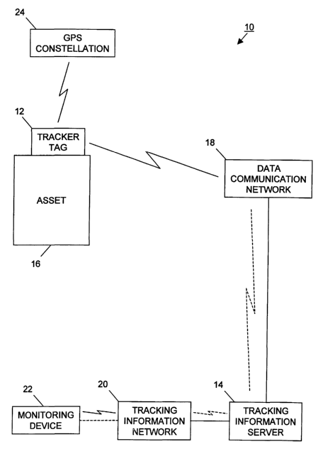
[00030] With reference to FIG. 1, an embodiment of a tracking system 10
includes a
tracker tag 12, a tracking information server 14, an asset 16, a data
communication
network 18, a tracking information network 20, a monitoring device 22, and a
GPS
satellite constellation 24. The GPS satellite constellation 24 is preferably a
public GPS
satellite constellation including a plurality of GPS satellites 240 (FIG. 3)
orbiting the
Earth. Each GPS satellite includes a clock and has an understanding of its own
orbit with
respect to the center of the Earth. Each GPS satellite continually broadcasts
its position
with respect to the center of the Earth and time with respect to a time of day
reference.
[00031) GPS satellites are well known for enabling users with GPS receivers to
locate
their positions on or near the Earth. Such systems are commonly used for
navigation in
many different applications, such as aviation, nautical travel, automobile
travel, etc.
Preferably, the GPS satellite constellation 24 includes enough GPS satellites
and the
satellites are spaced apart so that from any point on Earth, four GPS
satellites will be
above the horizon. Equipment with a GPS receiver can determine its position
with
respect to the center of the Earth in longitude, latitude, and altitude from
position and
time data from four GPS satellites. If position and time data is received from
three GPS
satellites, the equipment can determine its position in longitude and
latitude. The
equipment can also determine its velocity from the position and time data.
[00032] One public GPS satellite constellation is the NAVSTAR GPS satellite
constellation developed by the IJ. S. Department of Defense. The NAVSTAR GPS
satellite constellation includes 27 GPS satellites (24 operational, 3 spare)
orbiting at about
12,000 miles (19,300 km). The GPS satellites are dispersed around six planes
with at
least four GPS satellites in each plane. The orbits are arranged so that at
any time
anywhere on Earth, there are at least four GPS satellites above the horizon.
Preferably,
the GPS satellite constellation 24 is the NAVSTAR GPS satellite constellation.
However,
the tracking system 10 works just as well with any other public GP S satellite
constellation,
such as the GLONAS S satellite constellation maintained by the Russian
Federation or the
Galileo satellite constellation introduced by European countries. The GPS
satellite
constellation 24 could also be a private satellite system.
8
CA 02484901 2004-11-05
WO 03/104834 PCT/US03/14483
[00033] Preferably, the asset 16 is a movable asset, such as an aircraft.
However, the
tracker tag 12 may be secured to any type of asset for which tracking
information is
desired. For example, a truck, a van, an automobile, a cargo container, a
trailer, a bus,
a train, a locomotive, a rail car, and a watercraft. The tracker tag 12 is
secured to the
asset 16 in a manner so that it normally has line of sight access to the sky.
Preferably, the
tracker tag 12 is removably secured to a top-side exterior of the asset 16 at
its highest
point. However, any point with line of sight access to at least three or four
GPS satellites
is suitable. Access to at least four GPS satellite is required if altitude
tracking information
is desired. Preferably, the tracker tag 12 positioned on the asset 16 so that
no operators,
crew, or passengers can access tracker tag 12 during normal movement of the
asset. This
may prevent terrorists and other foes from being able to remove or disable the
tracker tag
12. Preferably, the tracker tag 12 is independently powered and electrically
isolated from
the asset and does not require manual intervention during normal operation
ofthe tracking
system 10. Again, this feature may prevent terrorists and other foes from
being able to
disable the tracker tag 12.
[00034] As long as the tracker tag 12 has line of sight access to the sky, it
selectively
receives wireless communications that are continuously broadcast by the GPS
satellite
constellation 24. The wireless communications include the position and time
data
continuously broadcast by each ofmultiple GPS satellites 240 (FIG. 3) that are
within line
of sight of the tracker tag 12. The tracker tag 12 combines the position and
time data
from each of the multiple GPS satellite to form combined position and time
data. The
tracker tag 12 is in communication with the tracking information server 14 via
the data
communication network 18 and selectively transmits the combined position and
time data
to the tracking information server 14. Preferably, with respect to the data
communication
network 18 and the tracking information server 14, the tracker tag 12 is a
thin client using
TCP/IP protocol.
[00035] The tracker tag 12 determines whether or not to receive the position
and time
data based on command and control information from the tracking information
server 14.
Similarly, the tracker tag 12 determines whether or not to transmit the
combined position
and time data based on command and control information from the tracking
information
server 14. Additionally, the tracker tag 12 may include an on-board sensor and
preprogrammed instructions to determine whether or not to receive the position
and time.
9
CA 02484901 2004-11-05
WO 03/104834 PCT/US03/14483
Similarly, the tracker tag 12 may include preprogrammed instructions to
determine
whether or not to transmit the combined position and time. Moreover, the
tracker tag 12
may also use an on-board sensor in conjunction with the preprogrammed
instructions to
determine whether or not to transmit the combined position and time. The
tracker tag
12 may receive the position and time data and store the combined position and
time data
for subsequent transmission.
[00036] The tracker tag 12 may include an algorithm to resolve the position
and time
data for its own position with respect to the center of the Earth. The
algorithm generates
XYZ data representing latitude, longitude, and altitude (requiring position
and time data
from at least four GPS satellites) or XY data representing latitude and
longitude (requiring
position and time data from at least three GPS satellites) in a trilateration
fashion
depending on the type of tracking information desired. Time data associated
with XYZ
or XY data is also generated. The resolution of the resolving algorithm is
about 18 inches
in latitude (~, about 18 inches in longitude (~, and about 18 inches in
altitude (Z). If
the resolving algorithm is implemented in the tracker tag 12, the combined
position and
time data includes XYZ or XY data and the associated time data. Typically, the
resolving
algorithm reduces the amount of data transmitted to the tracking information
server. The
tracker tag 12 may include a data compression process to further reduce the
amount of
time required for data transmissions. The tracker tag 12 may include
encryption and
decryption processes for secured communications with the tracking information
server 14.
As another alternative, the tracker tag 12 may include the encryption process
to secure
the combined position and time data transmissions. This may prevent terrorists
and other
foes from using the combined position and time data to locate and/or target
the asset.
[00037] Communications between the tracker tag 12 and the data communication
network 18 are wireless. Communications between the tracking information
server 14
and the data communication network 18 are preferably by wire. However, this
communication may also be wireless. The data communication network 18 may
implement any combination of wireless and wired communication technologies
suitable
for communications between the tracker tag and the tracking information server
14. The
data communication network 18 may be a public network, a private network, or
any
combination of public and private networks.
CA 02484901 2004-11-05
WO 03/104834 PCT/US03/14483
[00038] For example, the data communication network 18 may include one or more
of
data communication satellite systems, terrestrial telephone systems, cable
television
systems, computer networks, and other suitable data communication networks in
any
combination. The data communication satellite system may include a satellite
telephone
system or a private satellite network. The satellite telephone system may be
any public
satellite telephone system, such as the Iridium satellite system, the
Globalstar satellite
system, the Orbcomm satellite system, the Inmarsat satellite system, or any
other suitable
public satellite telephone system. The terrestrial telephone system may
include any
combination of land line or wireless telephone systems, such as the public
switched
telephone network (P STN), broadband integrated services digital network
(ISDN), digital
subscriber line (DSL), cellular telephone network, personal communication
system (PCS)
network, or any other suitable terrestrial telephone network. The computer
network may
include any combination of wire line local area networks (LANs) and wireless
LANs.
Preferably, the computer network is Ethernet (i.e., IEEE 802.3 for wire line
LAN and
IEEE 802. I 1 for wireless LAN). However, any other suitable network
communication
protocols may be implemented, such as token ring, fiber distributed data
interface (FDDI),
ARCNET, and HiperLAN.
[00039] These various communication technologies may be combined in any
combination to form a wide area network (WAN) or a metropolitan area network
(MAN).
Notably, the wireless communication between the tracker tag 12 and the data
communication network may be implemented by satellite, cellular telephone,
PCS,
wireless LAN, or any other suitable wireless technology.
[00040] The tracking information server 14 selectively provides command and
control
information to the tracker tag 12 and receives the combined position and time
data from
the tracker tag 12. The tracking information server 14 selectively processes
the combined
position and time data and selectively generates certain tracking information
for
monitoring movement of the asset 16. The tracking information server 14
selectively
makes the tracking information accessible to an authorized user of the
monitoring device
22 via the tracking information network 20. The authorized user, for example,
may be a
subscriber, an employee assigned to monitor the asset, an
operator/administrator
associated with the tracking information server 14. The tracking information
server 14
may also selectively receive command and control information from an
authorized user
11
CA 02484901 2004-11-05
WO 03/104834 PCT/US03/14483
ofthe monitoring device 22. Preferably, the tracking information server 14 is
compatible
with data communications via the data communication network 18 and the
tracking
information network 20 in TCP/n' protocol.
[00041 ] The tracking information server 14 may include preprogrammed
instructions
to determine: i) whether or not to provide commands or control information to
the tracker
tag 12, ii) whether or not to process the combined position and time data,
iii) whether or
not to generate tracking information and what type of tracking information to
generate,
iv) whether or not a user is authorized, v) whether or not to make tracking
information
accessible to an authorized user, and vi) whether or not to receive commands
or control
information from an authorized user. Other types of preprogrammed instructions
are also
possible. The preprogrammed instructions may be initially configured, edited,
and/or
supplemented by an authorized user of the monitoring device 22. Some of the
preprogrammed instructions may be initially configured, edited, and/or
supplemented,
while the tracking system 10 is tracking the asset 16.
[00042] The commands may include tracker tag commands to begin receiving
position
and time data, begin transmitting combined position and time data, stop
transmitting
combined position and time data, and stop receiving position and time data.
Commands
may also include tracking information server commands to begin processing
combined
position and time data, to begin generating certain types of tracking
information, to stop
generating certain types oftracking information, and to stop processing
combined position
and time data. Other types of commands are also possible.
[00043] The control information may include a tag profile, a link from the
tracker tag
to the asset, links from the asset to elements associated with the asset, and
link
information associated with either the asset or an element of the asset.
[00044] Typically, the tag profile is tailored to the type of asset being
tracked and the
tracking information services contracted for by a subscriber. The tag profile
may, for
example, specify real-time tracking, tracking on certain detected events,
periodic tracking,
and/or tracking on command. Additionally, the tag profile may include
thresholds
associated with detected events, parameters associated with predicting
estimated arrival
times and/or travel paths, types of tracking information authorized for
monitoring, and
types of tracking information reports authorized. More specifically, the tag
profile may
include: i) tracking information to be monitored and frequency, ii) vibration
thresholds
12
CA 02484901 2004-11-05
WO 03/104834 PCT/US03/14483
associated with startup and shutdown, iii) vibration thresholds associated
with normal
movement, iv) restricted areas, v) hazardous areas, vi) planned course, vii)
high stress
conditions, viii) fuel and fuel consumption information, and ix) reports to be
processed
and report frequency. Additional information may also be included in the tag
profile.
[00045] Typically, the tracker tag 12 includes tracker tag identification data
that is
embedded with communications to the tracking information server 14. This is
how the
tracking information server 14 identifies the combined position and time data,
particularly
when multiple tracker tags 12 are communicating with the tracking information
server 14.
The link from the tracker tag 12 to the asset 14 allows the tracking
information server to
associate the combined position and time data with the asset so that the
tracking
information can reference the asset. For example, the tracker tag
identification data may
be linked to an aircraft tail no. Similarly, the combined position and time
data can also be
associated with an element of the asset by the additional link from the asset
to the element.
For example, an element can be a fuel pump on an aircraft engine. The first
link may
associate the tracker tag identification data with the aircraft tail number
and the second
link may associate a fi~el pump serial no. with the aircraft tail no.
Additional examples of
elements include operators, crew member, passengers, asset owners, cargo
items,
operational equipment items, and support equipment items. Other types of
elements are
also possible. Multiple elements can be identified and linked to a given
asset.
[00046] Link information is descriptive information associated with a link For
example,
i) asset identification data, ii) asset certification, iii) asset operational
information, iv) asset
maintenance information, v) element identification data, vi) element
certification, vii)
element operational information, and viii) element maintenance information.
Other types
of link information are also possible.
[00047] The preprogrammed instructions in either the tracking information
server 14 or
the tracker tag 12 may include any combination of the various types of control
information. Likewise, the commands are typically included in the
preprogrammed
instructions so that, as certain events are detected or as certain sequences
occur, the
commands can be communicated automatically.
[00048] The tracking information server 14 may include the algorithm to
resolve
position and time data for the tracker tag 12 from raw GPS position and time
data
included in the combined position and time data. The algorithm generates XYZ
data
13
CA 02484901 2004-11-05
WO 03/104834 PCT/US03/14483
representing latitude, longitude, and altitude (requiring position and time
data from at least
four GPS satellites) or XY data representing latitude and longitude (requiring
position and
time data from at least three GPS satellites) in the same manner as described
above if the
resolving algorithm is performed in the tracker tag 12. The algorithm also
generates time
data associated with XYZ or XY data. The tracking information server 14 may
include
a data decompression process to decompress compressed combined position and
time data
transmissions. The tracking information server 14 may include encryption and
decryption
processes for secured communications with the tracker tag 12. As another
alternative, the
tracking information server 14 may include the decryption process to decrypt
secure
combined position and time data transmissions.
[00049] The tracking information network 20 may implement any combination of
wireless and wired communication technologies suitable for communications
between the
tracking information server 14 and the monitoring device 22. Preferably,
communications
between the tracking information network 20 and the tracking information
server I4 and
between the tracking information network 20 and the monitoring device 22 are
both by
wire. However, either of these communications may wireless or both may be
wireless.
Like the data communication network 18, the tracking information network 20
may be
a public network, a private network, or any combination of public and private
networks.
As such, the networks identified above for the data communication network 18
may also
be implemented in the tracking information network 20. Notably, the tracking
information
network 20 may include the Internet, which is accessible through each of the
major
communication systems identified above. The tracking information network 20
and the
data communication network 18 may be linked together forming a common tracking
system network.
[00050] The monitoring device 22 is any type of device suitable for
communicating with
the tracking information server 14 and displaying the tracking information.
For example,
a personal computer, a notebook computer, a personal digital assistance, a
wireless
personal digital assistance, a cellular telephone, a satellite telephone, a
pager, or any other
suitable display device. Preferably, the tracking information server 18
provides tracking
information via a Web server connected to the Internet with suitable security
measures.
Accordingly, the monitoring device 22 preferably has access to the Internet
for receiving
the tracking information and monitoring movement of the asset. However, the
public
14
CA 02484901 2004-11-05
WO 03/104834 PCT/US03/14483
Internet is not required for communications between the monitoring device 22
and the
tracking information server 14. Other alternatives include communications
through a
private network or one-to-one dial-up-type connections through a public
network.
[00051] While FIG. 1 depicts a tracking system 10 with one tracker tag 12 and
one
monitoring device 22, the system can be expanded to include multiple tracker
tags and/or
multiple monitoring devices. Use of multiple tracker tags allows a user to
monitor
multiple assets, such as a fleet of aircraft or all airborne aircraft. Use of
multiple
monitoring devices allows multiple users to monitor an asset. For example, a
cargo
aircraft can be monitored by various users associated with the cargo, as well
as users
associated with aircraft owner, the aircraft fuel pump manufacturer, the
transport
company, and government regulatory agencies. Of course use of both multiple
tracker
tags and multiple monitoring devices provides a combination of additional
scenarios.
[00052] Preferably, the tracking information server 14 is housed in a single
facility.
However, it may be distributed among multiple facilities and networked
together.
Preferably, the tracking information server 14 is a ground-based system.
However, other
types of platforms are possible, such as an airborne platform or a ship-based
platform.
[00053] With reference to FIG. 2, an embodiment of a global tracking system 26
includes the tracker tag 12, the tracking information server 14, the asset 16,
the
monitoring device 22, the GPS satellite constellation 24, an Iridium satellite
constellation
28, an Iridium satellite/PSTN gateway 30, a PSTN 32, an Iridium
satellite/Internet
gateway 34, and an Internet 36. The tracker tag 12, tracking information
server 14, asset
16, monitoring device 22, and GPS satellite constellation 24 are as described
above in
reference to FIG. 1.
[00054] A global implementation of the tracking system 26 is provided by a
data
communication network 18 (FIG. 1) and a tracking information network 20 (FIG.
1) that
provide global coverage (i.e., worldwide communications). The data
communication
network 18 (FIG. 1) is provided by a satellite telephone system and a
terrestrial telephone
network. As shown, the preferred satellite telephone system is the Iridium
telephone
system. However, other satellite telephone systems that provide global
coverage may also
be implemented in the global tracking system 26. The preferred terrestrial
telephone
network is the PSTN. However, other types of terrestrial telephone networks
may be
implemented. More specifically, the data communication network 18 (FIG.1) is
provided
CA 02484901 2004-11-05
WO 03/104834 PCT/US03/14483
by the Iridium satellite constellation 28, the Iridium satellite/PSTN gateway
30, and the
PSTN 32.
[00055] In the embodiment being described, the tracking information network 20
(FIG.
1) is provided by a satellite telephone system and the Internet 36. As shown,
the preferred
satellite telephone system is the Iridium telephone system. However, other
satellite
telephone systems that provide global coverage may also be implemented in the
global
tracking system 26. More specifically, the tracking information network 20
(FIG. 1) is
provided bythe Iridium satellite constellation 28, the Iridium
satellite/Internet gateway 34,
and the Internet 3 6.
[00056] Global coverage of the tracker tag 12 secured to the asset is provided
by the
Iridium satellite system. Likewise, global access to the tracking information
by a
subscriber/client user at the monitoring device is provided by the Iridium
satellite system.
In an additional embodiment of a global tracking system, if global access is
not required,
the tracking information network 20 (FIG. 1) may implement other communication
networks that provide regional or local access to the tracking information
server 14 while
the data communication network 18 provides global coverage. Conversely, in an
another
embodiment of a global tracking system, if global tracking is not required,
the data
communication network 18 (FIG. 1) may implement other communication networks
that
provide regional or local tracking of the asset while the tracking information
network 20
provides global coverage.
[00057] With reference to FIG. 3, the GPS satellite constellation 24 includes
multiple
GPS satellites 240 orbiting Earth 37.
[00058] With reference to FIG. 4, the Iridium satellite constellation 28
includes 66
Iridium satellites 280 orbiting Earth 37 in low Earth orbit (LEO) at an
average altitude of
420 miles (670 km). The Iridium satellites 280 lie in six (6) orbital planes,
with eleven
(11) satellites per orbital plane. Within the Iridium satellite system, the
Iridium satellites
280 communicate with Iridium telephones (i.e., radio transceivers or two-way
radios) and
gateways to terrestrial land line and wireless telephone systems, as well as
gateways to the
Internet. Notably, with the Internet gateway, the Iridium satellite system is
an Internet
service provider (ISP). Worldwide voice, data, and Internet services over the
Iridium
satellite system are provided by Iridium Satellite LLC.
16
CA 02484901 2004-11-05
WO 03/104834 PCT/US03/14483
[00059] With reference to FIG. 5, the altitude of exemplary data communication
satellite constellation orbits are illustrated. The Iridium satellite
constellation 28, an
Orbcomm satellite constellation 40, a Teledesic satellite constellation 41, a
Globalstar
satellite constellation 42, and a Skybridge satellite constellation 43 orbit
Earth 37 at LOE.
A Concordia satellite constellation 44, an Orblink satellite constellation 45,
and an ICO
satellite constellation orbit at a medium Earth orbit (MEO). A NAVSTAR GPS
satellite
constellation 38 and a Glonass satellite constellation 39 orbit Earth at a
higher altitude.
[00060] FIG. 5 illustrates various orbital altitudes for satellite
constellations that may
be used to implement the present application. By use of one or more of these
satellite
systems, the intended operations are obtained as discussed herein.
[00061] With reference to FIG. 6, in one embodiment of the tracking system 10,
GPS
data flows from the GPS satellite 240 to the tracker tag 12 on the asset 16
(e.g., a general
aviation aircraft). Data transmissions from the tracker tag data are relayed
by the Iridium
satellite 280 to the Iridium satellite/PSTN gateway 28.
[00062] FIG. 6 particularly notes that the tracker tag sends data to an
Iridium satellite
which in turn sends this information to a ground station, and further use is
shown of GPS
satellites providing information to the tracker tag.
[00063] With reference to FIG. 7, an embodiment of the tracker tag 12 includes
a
power source and conversion module 47, a data communication link 48, and a
data
acquisition and processing module 49. The power source and conversion module
47
provides electrical power to the data communication link 48 and the data
acquisition and
processing module 49. This permits the tracker tag 12 to operate independent
of external
power sources. The data acquisition and processing module 49 selectively
receives
position and time data from GPS satellites 240 (FIG. 3) within line of site of
the tracker
tag 12 and combines the raw GPS position and time data to form combined
position and
time data and selectively stores the combined position and time data. The data
acquisition
and processing module 49 selectively communicates the combined position and
time data
to the data communication link 48. The data communication link 48 selectively
transmits
the combined position and time data to the tracking information server 14
(FIG. 1) via the
data communication network 18 (FIG. 1). The data communication link 48 also
receives
commands and control information from the tracking information server 14 (FIG.
1).
17
CA 02484901 2004-11-05
WO 03/104834 PCT/US03/14483
[00064] In the embodiment being described, the power source and conversion
module
47 includes a power source 50, a backup battery 52, a power distribution
module 54, and
a battery charger 56. The power source 50 provides power to the power
distribution
module 54. The power source 50 may include any combination of a piezoelectric
power
generator, a solar collector panel 86 (FIG. 8), and a primary battery, as well
as other types
of suitable power sources. The power distribution module 54 conditions the
power so
that suitable power is provided to the various components of the tracker tag
12. The
power distribution module 54 distributes power to the battery charger 56, data
communication link 48, and data acquisition and processing module 49. The
battery
charger 56 selectively applies charge current to the backup battery 52. For
example, when
power from the power source is low, the battery charger 56 may not apply the
charge
current. The backup battery 52 selectively provides power to the power
distribution
module 54. For example, when power from the power source is suitable, the
backup
battery 52 may not provide power to the power distribution module 54.
[00065] In the embodiment being described, the data communication link 48
includes
an RF antenna 58, a radio transceiver 60, and an encryptionldecryption process
62. The
radio transceiver 60 and RF antenna 58 selectively transmit the combined
position and
time data to the tracking information server 14 (FIG. 1) via data
communication network
18 (FIG. 1). The RF antenna 58 and radio transceiver 60 also receive commands
and
control information from the tracking information server 14 (FIG. 1). The
encryption/decryption process 62 is optional and may encrypt and/or decrypt
any type of
communication transmitted or received by the tracker tag 12. The
encryption/decryption
process 62 may encrypt all communications to the tracking information server
14 and
decrypt all communications from the tracking information server 14.
Alternatively, the
encryption/decryption process 62 may be limited to encrypt the combined
position and
time data transmitted to the tracking information server 14.
[00066] In the embodiment being described, the data acquisition and processing
module
49 includes a GPS antenna 64, a GPS receiver 65, an environmental sensor 66, a
control
device 67, and a controller 68. The GPS antenna 64 and GPS receiver 65
selectively
receive position and time data from GPS satellites 240 (FIG. 3) within line of
site of the
tracker tag 12. The controller 68 combines the raw GPS position and time data
to form
the combined position and time data and selectively stores the combined
position and time
18
CA 02484901 2004-11-05
WO 03/104834 PCT/US03/14483
data. The controller 68 selectively communicates the combined position and
time data to
the data communication link 48.
[00067] The environmental sensor 66 is optional. If implemented, the
environmental
sensor 66 may include one or more accelerometers. The environmental sensor 66
senses
vibration and provides vibration measurements to the controller 68. The
controller
compares the vibration measurements with predetermined thresholds to detect
various
types of events. For example, using the vibration measurements, the controller
can detect
i) startup of a power plant associated with the asset 16 (FIG. 1), ii)
shutdown of the
power plant, iii) start of movement of the asset, iv) cessation of movement of
the asset,
v) excessive increase in acceleration ofthe asset, and vi) excessive decrease
in acceleration
of the asset. Typically, the controller 68 selectively stores detected event
data along with
associated combined position and time data. The environmental sensor 66 may
also sense
other types of environmental conditions.
[00068] The controller 68 may use a detected event to determine whether or not
the
tracker tag 12 should begin receiving the position and time data, begin
storing the
combined position and time data, and begin transmitting the combined position
and time
data. For example, the controller 68 can cause the tracker tag 12 to begin
receiving
position and time data and begin storing combined position and time data when
the
aircraft takes off, begin transmitting combined position and time data when
the aircraft
begins to move, stop transmitting after a predetermined period of time, begin
transmitting
again when the aircraft experiences turbulence, stop transmitting again after
a
predetermined period of time, stop receiving position and time data when the
aircraft
stops moving, begin transmitting again when the aircraft stops moving, and
stop
transmitting when all the stored combined position and time data is
transmitted.
[00069] The control device 67 is optional and provides for manual startup and
shutdown of the tracker tag 12. The control device 67 can be any type of
switch or
control suitable for its intended purpose. The control device 67 is in
communication with
the controller 68 and the power source and conversion module 47. Upon a
startup
activation of the control device 67, the power source 50 is enabled and the
controller 68
begins an orderly power up sequence. Upon a shutdown activation, the
controller 68
begins an orderly shutdown sequence and, at a suitable time, disables the
power source
50.
19
CA 02484901 2004-11-05
WO 03/104834 PCT/US03/14483
[00070] In the embodiment being described, the controller 68 includes a
processor 70,
a storage device 72, and an auxiliary inputloutput (I/O) port 74. The
processor is in
communication with the GPS receiver 65, environmental sensor 66, control
device 67,
storage device 72, auxiliary I/O port 74, and data communication link 48. The
storage
device 72 includes a data buffer 76, a tracker tag identification data 78, and
a tag profile
79. The processor 70 receives position and time data from the GPS receiver 65.
The
processor 70 combines the raw GPS position and time data to form the combined
position
and time data and selectively stores the combined position and time data in
the data buffer
76. The processor 70 selectively communicates the combined position and time
data from
the data buffer 76 to the data communication link 48.
[00071] The processor 70 may include the resolving algorithm described above
in
reference to FIG. 1. When using the resolving algorithm, the processor 70 may
temporarily store the combined position and time data while generating the XYZ
or XY
data and associated time data. Once the XYZ or XY data and associated time
data is
generated it is stored in the data buffer 70 and the corresponding raw GPS
position and
time data is purged. The combined position and time data communicated to the
data
communication link 48 includes the XYZ or XY data and associated time data
instead of
the raw GPS position and time data.
[00072] The processor 70 detects the events associated with vibration
measurements
described above. The processor 70 may use the XYZ or XY data to detect
additional
events related to the position of the asset. The processor 70 compares the XYZ
or XY
data to predetermined XYZ or XY coordinate limits to detect certain events.
For
example, the processor 70 may detect When the asset is i) in the proximity of
a restricted
area, ii) in a restricted area, iii) in the proximity of a hazardous area, iv)
in a hazardous
area, v) at a way point, vi) at a destination, vii) off course, viii) nearing
a high stress
condition, ix) experiencing a high stress condition, x) experiencing excessive
loss of
altitude, xi) experiencing excessive increase in altitude, xii) experiencing
unexpected
stoppage or significant slow down, or xiii) exceeding a speed restriction.
Additional types
of detected events are also possible.
[00073] Typically, the processor 70 selectively stores detected event data
along with
associated combined position and time data. Like detected events associated
with
vibration, the processor 70 may use any of the detected events associated with
position
CA 02484901 2004-11-05
WO 03/104834 PCT/US03/14483
and time to determine whether or not the tracker tag 12 should begin receiving
the
position and time data, storing the combined position and time data, and
transmitting the
combined position and time data. Additionally, any type of detected event can
be included
in the tracking information provided to the subscriberlclient user at the
monitoring device
22 (FIG. 1 ).
[00074] The processor 70 receives command and control information from the
data
communication link 48. The information stored in the tag profile 79 may be
predetermined and may be provided in control information. Alternatively, the
tag profile
79 may be predetermined and permanently resident in the storage device 72. In
another
alternative, the tag profile 70, or certain information within the tag profile
70, may be
configured and/or edited during operation of the tracker tag 12.
[00075] The processor 70 manages data transmissions to the tracking
information server
14 (FIG. 1) by controlling when the combined position and time data is
communicated
from the data buffer 76 to the data communication link 48. Typically, the
processor 70
controls data transmissions in a burst fashion by waiting for a group of the
combined
position and time data to accumulate in the data buffer 76. This may be based
on
commands, control information, and/or the tag profile 79. The processor 70
encodes
each transmission burst with tracker tag .identification data 78 so that the
tracking
information server 14 can associate the data transmitted with the appropriate
tracker tag
12. Event data is typically stored in the data buffer 76. A transmission burst
may also
include event data associated with the combined position and time data
contained in the
burst.
[00076] In one embodiment, the processor controls the timing between
transmission
bursts to maintain a virtual private network (VPN) connection over a public
data
communication system within the data communication network 18 (FIG. 1 ). For
example,
the public data communication system may be the Iridium satellite system, a
similar
satellite system, or any type of wireless telephone system that provides for
VPNs. The
processor 70 may control the timing between transmission bursts so that the
tracking
system 10 (FIG. 1) can provide real-time tracking information. Alternatively,
the
processor 70 may control the timing to minimize transmission time over the
data
communication network. Thus, minimizing communication costs for public
telephone
networks or other carriers that charge for connect time. As another
alternative, the
21
CA 02484901 2004-11-05
WO 03/104834 PCT/US03/14483
processor 70 may delay transmission bursts until a begin transmitting command
is received
via the data communication network. Typically, the processor 70 maintains the
combined
position and time data in the data buffer associated with each transmission
burst until an
acknowledgment of receipt of the transmission burst is received via the data
communication network 18 (FIG. 1).
[00077] The auxiliary I/O port 74 is optional and provides a port for directly
connecting
a computer device to the tracker tag 12. The computer device, for example, can
be used
to perform tracker tag maintenance or to download combined position and time
data from
the data buffer 76. The computer device may be a personal computer, a notebook
computer, a personal digital assistance, or a similar device.
[00078] With reference to FIG. 8-10, one embodiment of the tracker tag 12 has
a
teardrop-shaped housing 80. Two air movement power/fan tubes 82 with power
airflow
levers 84 inside a portion of the tubes are provided in the housing 80. A
solar collector
panel 86 is secured to the top of the housing 80. The power airflow levers 84
and the
solar collector panel 86 generate power and act as supplemental power sources
(FIG. 50).
Airflow 90 perpendicular to the leading edge 88 of the tracker tag 12
activates the power
airflow levers 84 to generate electrical power. The solar collector panel 86
generates
electrical power from light.
[00079] With reference to FIG. 9, for the embodiment being described, the
power
source and conversion module 47, data communication link 48, and data
acquisition and
processing module 49 are shown with the top of the housing 80 removed.
[00080] In FIGS. 8 and 9, illustrated is one embodiment of a tracker tag
according to
the concepts of the invention. As previously noted, since this tracker tag is
entirely
independent from the power source of the aircraft, ground vehicle or
watercraft, various
power generating mechanisms are provided unto the tracker tag itself. For
example,
tracker tag 12 will include airflow technology having an air movement
power/fan tube 82
and power air flow levers 84. As air flow 90~ enters the tube, electrical
power is
generated. For additional power source, a solar collector panel 86 is also
provided on the
tracker tag. A backup battery 52 (FIG. 7) is interconnected with the power
source and
conversion module 47 (FIG. 7) within the tracker tag 12 to insure a constant
operation
of the tracker tag. The battery may be selectively recharged by one of the
alterative
power sources. To provide the communication from the tracker tag on the
aircraft,
22
CA 02484901 2004-11-05
WO 03/104834 PCT/US03/14483
ground vehicle or watercraft to a tracking information server 14 (FIG. 1) or
other
appropriate location such as through the Internet, the tracking system also
includes a
multidirectional transmission and reception antenna and a radio-GP S receiver
and RF two-
way radio system package. It is also noted that this embodiment forms the
tracker tag 12
with a low profile tear-shaped design in order to cut down on wind resistance.
[00081] With reference to FIG. 10, for the embodiment being described, the
aerodynamic nature of the teardrop-shaped housing 80 is shown in a side view.
As
shown, the leading edge 88 is on the left.
[00082] FIG. 10 illustrates the side profile of the tracker tag 12 placed on
the fuselage.
As larger overall picture showing the mounting of tracker tag 12 on an
aircraft is also
illustrated in FIG. 6. As can be noted from these figures, the tracker tag 12
is physically
and electrically isolated from the internal systems of the aircraft. This
insures
independence of the tracker tag at all times.
[00083] It is further noted that, while the tracker tag is shown in this
embodiment in a
low profile tear-drop shape, other aerodynamic designs may also be
appropriate. Further,
while the power generation has been illustrated as an air mount power fan tube
and the
solar collector panel, as well as the backup battery, it is to be appreciated
that other forms
of energy generation mechanisms may also be implemented. For example, but not
limiting
the discussion, one may also use fuel cells, hydrogen cells, turbine
technology, fly wheel
technology and still other power generation arrangements in order to insure
the reliable
operation of tracker tag 12. Additionally, the tracker tag 12 may be attached
to a ground
vehicle or a watercraft.
[00084] With reference to FIG. 11, an embodiment of the tracking information
server
14 includes a system controller 92, a communication link 94, a data warehouse
96, a Web
server 98, a file server 100, and a client communication interface 102. The
communication link 94 selectively provides command and control information to
the
tracker tag 12 (FIG. 1) and receives the combined position and time data from
the tracker
tag 12. The data warehouse 96 selectively processes the combined position and
time data
to form tag data, asset data, and/or element data.
[00085] The Web server 98 includes a set of Web pages for displaying tracking
information. The Web server 98, in conjunction with the data warehouse 96
mining the
tag data, asset data, and/or element data, selectively populates one or more
of the Web
23
CA 02484901 2004-11-05
WO 03/104834 PCT/US03/14483
pages with certain tracking information for monitoring movement of the asset
16 (FIG.
1). The Web server 98, in conjunction with the client communication interface
102,
selectively makes the tracking information accessible to an authorized user of
the
monitoring device 22 (FIG. 1) via the tracking information network 20 (FIG.
1).
[00086] . The data warehouse 96 may also process the tag data, asset data,
and/or
element data into tag reports, asset reports, and/or element reports. If
report processing
is implemented, the tag reports, asset reports, and/or element reports are
stored on the file
server 100. The Web server 98, in conjunction with the file server 100 and the
client
communication interface 102, selectively makes the tag reports, asset reports,
and/or
element reports accessible to an authorized user of the monitoring device 22
(FIG. 1) via
the tracking information network 20 (FIG. 1).
[00087] The Web server 98, in conjunction with the client communication
interface 102,
may selectively receive links between tracker tag identification data and
assets, as well as
associated link information, from an authorized user ofthe monitoring device
22 (FIG. 1).
Likewise, the Web server 98 may selectively receive links between an asset and
elements
associated with the asset, as well as associated link information, from an
authorized user.
The data warehouse 96 stores the links and link information collected by the
Web server
98 for use during generation of asset data and element data.
[00088] The system controller 92 provides overall control of the tracking
information
server 14 and, in conjunction with the communication link 94, control of the
tracker tag
12. Overall control may be based on preprogrammed instructions and the tag
profile are
stored in the system controller 92. The preprogrammed instructions includes
commands
and control information. The tag profile includes control information, as
described above.
The system controller 92, in conjunction with the client communication
interface 102, may
selectively receive command and control information from an authorized user of
the
monitoring device 22 (FIG. 1) to configure and/or edit the preprogrammed
instructions
andlor the tag profile.
[00089] In the embodiment being described, the system controller 92 includes a
command and control module 103 and a tag profile 104. The command and control
module 103 processes preprogrammed instructions for overall control of the
tracking
information server 14 and, in conjunction with the communication link 94 and
the data
communication network 18 (FIG. 1), control of the tracker tag 12 (FIG. 1) by
24
CA 02484901 2004-11-05
WO 03/104834 PCT/US03/14483
communicating commands and control information. Certain parts of overall
control may
be based on the tag profile 104. The information stored in the tag profile 104
may be
predetermined and may be provided in control information. Alternatively, the
tag profile
104 may be predetermined and permanently resident. In another alternative, the
tag
profile 104, or certain information within the tag profile 104, may be
configured and/or
edited during operation of the tracking information server 14 and associated
tracker tag
12 (FIG. 1).
[00090] In the embodiment being described, the communication link 94 includes
an RF
antenna 105, a radio transceiver 106, and an encryptionldecryption process
108. The RF
antenna 105 and radio transceiver 106 and selectively receive the combined
position and
time data from the tracker tag 12 (FIG. 1) via data communication network 18
(FIG. 1).
The radio transceiver 106 and RF antenna 105 also transmit commands and
control
information to the tracker tag 12 (FIG. 1). The encryption/decryption process
108 is
optional and may encrypt and/or decrypt any type of communication transmitted
or
received by the tracking information server 14. The encryption/decryption
process 108
may encrypt all communications to the tracker tag 12 and decrypt all
communications
from the tracker tag 12. Alternatively, the encryption/decryption process 108
may be
limited to decrypt the combined position and time data received from the
tracker tag 12.
[00091] In the embodiment being described, the data warehouse 96 includes a
combined
position and time storage area 110, a tag/asset/element link table 112, a data
processor
114, a tag data storage area 116, an asset data storage area 118, an element
data storage
area 120, a data mining process 122, and a report processor 124. The combined
position
and time storage area 110 receives the combined position and time data from
the tracker
tag (FIG. 1) via the communication link 94.
[00092] The tag/asset/link table 112 stores the links and link information
collected by
the Web server 98. The link from the tracker tag 12 to the asset 14 allows the
data
processor 114 to associate the combined position and time data with the asset
so that
asset data may be generated. Similarly, the link from the asset 14 to an
element of the
asset allows the data processor 114 to associate the combined position and
time data with
the element so that element data may be generated. Link information is
descriptive
information that may be associated with an asset or an element. The link
information is
accessible to the report processor during generation of the asset and element
data.
CA 02484901 2004-11-05
WO 03/104834 PCT/US03/14483
[00093] The data processor 114 may include a data decompression process to
decompress compressed combined position and time data transmissions. Ifthe
combined
position and time data does not include XYZ or XY data, the tracking
information server
14 includes the algorithm to resolve position and time data for the associated
tracker tag
12 from raw GPS position and time data described above in reference to FIG. 1.
The
algorithm generates XYZ data representing latitude, longitude, and altitude
(requiring
position and time data from at least four GPS satellites) or XY data
representing latitude
and longitude (requiring position and time data from at least three GPS
satellites) in the
same manner as described above if the resolving algorithm is performed in the
tracker tag
12. The algorithm also generates time data associated with XYZ or XY data.
[00094] Whether or not the data processor 114 calculates the XYZ or XY data,
the data
processor 114 may use the ~YZ or XY data to detect events related to the
position ofthe
asset. The data processor 114 compares the XYZ or XY data to predetermined XYZ
or
XY coordinate limits to detect certain events. The types of events that can be
detected
by the data processor 114 based on position include the same examples listed
above for
the tracker tag 12. Of course, additional types of detected events are also
possible.
Typically, the detected events are communicated to the system controller 92 so
that the
system controller 92 can communicate suitable commands in response to the
detected
event. Typically, the data processor 114 selectively stores detected event
data along with
associated combined position and time data.
[00095] The data processor 114 selectively processes the combined position and
time
data, detected event data, and link information based on control information
from the
controller (i.e., preprogrammed instructions and tag profile 104), links from
the
taglasset/element link table, and detected events to form tag data, asset
data, and/or
element data. The tag data is stored in the tag data storage area 116. The
asset data is
stored in the asset data storage area 118. The element data is stored in the
element data
storage area 120. The data mining process 122 mines the tag data, asset data,
and/or
element data based on data required by the Web server 98 to populate one or
more of the
Web pages with tracking information.
[00096] The report processor 124 is optional. If report processing is
implemented, the
report processor 124 selectively processes the tag data into tag reports, the
asset data into
asset reports, and the element data into element reports. The report processor
124
26
CA 02484901 2004-11-05
WO 03/104834 PCT/US03/14483
communicates the tag, asset, and element reports to the file server 100 for
storage. For
example, the tag reports may include: i) raw GPS position and time data, ii)
XYZ position
and time data, and iii) detected event data. Other type of tag reports are
also possible.
For example, the types of asset reports may include: i) asset log, ii)
operation log, iii)
operator log, iv) location and time in restricted area, v) location and time
in hazardous
area, vi) location and time off course, v) location and time in high stress
condition, and
vi) location and time of unexpected stoppage. Other types of asset reports are
also
possible. For example, the types of element reports may include: i) element
log, ii)
operation log, iii) operator log, iv) location and time in restricted area, v)
location and
time in hazardous area, vi) location and time offcourse, v) location and time
in high stress
condition, and vi) location and time of unexpected stoppage. Other types of
element
reports are also possible.
[00097] Notably, if the asset is an aircraft, the asset log available from the
tracking
information server 14 may be tailored to replace the traditional aircraft log.
Similarly, the
operation log may be tailored to replace the traditional flight operation log
and the
operator log may be tailored to replace the traditional pilot log. Another
aircraft report
could identify the number of hours the aircraft has been above 14,000 feet or
pressurized.
Moreover, if the element is a fuel pump on an aircraft engine, a location and
time in high
stress condition report can identify the total number of hours the engine has
been exposed
to high pressure conditions. Another fuel pump report could identify takeoffs
and/or
landings and associated conditions.
[00098] In the embodiment being described, the Web server 98 includes a data
applet
126, a map applet 128, a map storage area 130, a tracking information module
132, and
a tag/asset/element link input/edit module 134. The tracking information
module 132
includes the set of Web pages. The tracking information module 132 presents
tracking
information to an authorized client user at a monitoring device 22 (FIG. 1)
via the Web
pages in response to client user selections and requests presented via one or
more of the
Web pages.
[00099] The map applet 128 and data applet 126 are web-based programs that
respond
to selections and requests by an authorized client user. Typically, the
tracking information
module 132 typically presents tracking information via a map retrieved from
the map
storage area 130, supplemental graphics overlaid on the map by the map applet
128 and
27
CA 02484901 2004-11-05
WO 03/104834 PCT/US03/14483
supplemental text provided by the data applet 126. The map may be any map that
is
suitable for type of asset being track. For example, the map storage area 130
may include
one or more of a street map 136, an aviation map 138, a water map 140, a rail
map 142,
and a three-dimensional (3D) environment. Other types of maps may also be
provided.
[000100] The map applet 128 may default to providing the aviation map 138 to
an
appropriate Web page for tracking an aircraft. The Web page may permit the
client user
to select a dii~erent map. If the client user selects a dii~erent map, the map
applet 128
changes the Web page to the display the selected map. Similarly, the data
applet 126 may
retrieve certain tag, asset, and/or element data from the data warehouse 96
and provide
it to a given Web page by default. The Web page may permit the client user to
select
additional or different tracking information. If so, the data applet 126
responds to client
user selections and requests accordingly.
[000101] In conjunction with the map and textual position and time tracking
information, the data applet 126 retrieves XYZ or XY position and time data
from the
data warehouse 96. The XYZ or XY position data is provided to the map applet
128 and
the tracking information module 132. The map applet 128 generates an icon
representing
the XYZ or XY position on the map and overlays it on the map display provided
to the
tracking information module 132. Multiple types of icons may be used, as well
as
coloring, flashing, and other suitable attributes ofthe icon, to symbolize
certain conditions
associated with the asset. Of course, many other features that can be
incorporated in Web
pages can also be implemented to provide the tracking information.
[000102] A sample map with several types of overlaid icons is provided in FIG.
12.
While FIG. 12, does not include textual information, the XYZ or XY position
and time
can also be overlaid on the map at a suitable location. Morever, icons and
data for
additional assets can be overlaid on the rnap for tracking, for example, a
fleet of aircraft
or all airborne aircraft. The tracking information module 132 typically
permits panning
and zooming of the map display so that the client user can adjust the display
to a particular
preference.
[000103] The Web server 98 typically includes one or more Web pages that
permit an
authorized user to configure links and link information. The tag link
input/edit module
134 works in conjunction with the one or more Web pages to collect the link
and link
information and communicate it to the data warehouse 96. The Web server 98
also
28
CA 02484901 2004-11-05
WO 03/104834 PCT/US03/14483
typically includes Web pages that permit an authorized user to configure the
tag profile
104.
[000104] Within the set of Web pages, the client user typically has access to
textual
information providing an audit trail for a particular tag, asset, andlor
element. Notably,
the concept of linking assets to tracker tags and elements to assets has the
advantage of
accumulating historical data for assets and elements that goes across
different tracker tags
and different assets. For example, if a tracker tag on an aircraft is replaced
for any reason,
the link between the asset and tracker tag is updated and the asset data for
the aircraft
includes data provided by the initial tracker tag and data provided by the new
tracker tag.
Thus, historical tracking information and reports for the aircraft can be
comprehensive.
Similarly, if a fuel pump for an aircraft engine happens to be removed from
one aircraft
and installed on another aircraft, the element data for the fuel pump is
comprehensive as
long as the link between the element and asset is updated.
[000105] In the embodiment being described, the file server 100 and includes a
tag
reports storage area 144, an asset reports storage area 146, an element
reports storage
area 148, and a file transfer module 150. The file transfer module 150
retrieves tag, asset,
and/or element reports from the storage in responds to requests for reports
from the Web
server 98. Typically, this is in response to selections or requests from the
client user via
a Web page.
[000106] In the embodiment being described, the client communication interface
102
includes a network interface 152, an Internet interface 154, an unsecured area
156, and
a security check 158. The network interface 152 provides a standard interface
to a
communication network in the tracking information network. For example, the
network
interface 152 may connect to a LAN, wireless LAN, terrestrial telephone
network,
satellite system, or any other suitable communication network. The Internet
interface 154
provides any type of standard interface to the Internet. Other suitable
interfaces to the
tracking information server 14 are also possible. Preferably, the monitoring
device 22
accesses the tracking information server via the Internet interface 154.
[000107] The unsecured area 156 does not provide tracking information. This
area
requires the client user to perform a login sequence. The login information is
provided
to the security check 158 to determine whether or not the client user is
authorized to enter
the Web server for monitoring tracking information, to configure the tag
profile 104, or
29
CA 02484901 2004-11-05
WO 03/104834 PCT/US03/14483
configure links and link information. The unsecured area 156 may be Web-based
and may
contain information describing the tracking system and/or tracking services.
[000108] With reference to FIG. 12, an example of a portion of a monitoring
device 22
(FIG. 1) display shows a street map 162. An aircraft departing from Chicago,
Illinois 164
and arriving in Jamestown, New York 166. The tracking information 168 is shown
by the
sequence of arrows pointing from Chicago to Jamestown.
[000109] FIG. 12 illustrates a map showing a portion of the United States
wherein the
arrows from Chicago to Jamestown, New York illustrate the path which would be
visually
shown to a user having access to the tracking system. This would allow the
user to
constantly track the progress of the flight or ground vehicle of interest. It
is also possible
to provide such map tracking of watercraft.
[000110] With reference to FIG. 13, an embodiment of a regional tracking
system 170
includes the tracker tag 12, the tracking information server 14, the asset 16,
the
monitoring device 22, the GPS satellite constellation 24, the PSTN 32, the
Internet 36,
a cellular telephone network 172, and a cellular telephone/PSTN gateway 174.
The
tracker tag 12, tracking information server 14, asset 16, monitoring device
22, and GPS
satellite constellation 24 are as described above in reference to FIG. 1.
[000111] A regional implementation of the tracking system 170 is provided by a
data
communication network 18 (FIG. 1) and a tracking information network 20 (FIG.
1) that
provide regional coverage (i.e., regional communications). The data
communication
network 18 (FIG. 1) is provided by a wireless terrestrial telephone system and
a land line
terrestrial telephone network. The preferred wireless terrestrial telephone
system is a
cellular telephone system. However, other wireless terrestrial telephone
systems that
provide regional coverage may be implemented. The preferred terrestrial
telephone
network is the PSTN. However, other types of terrestrial telephone networks
may be
implemented. More specifically, the data communication network 18 (FIG. 1) is
provided
by the cellular telephone network 172, the cellular telephone/PSTN gateway
174, and the
PSTN 32.
[000112] In the embodiment being described, the tracking information network
20
(FIG. 1) is provided by a terrestrial telephone system and the Internet 36. As
shown, the
preferred terrestrial telephone system is a land line telephone system.
However, other
terrestrial telephone systems that provide regional coverage may also be
implemented in
CA 02484901 2004-11-05
WO 03/104834 PCT/US03/14483
the regional tracking system 170. More specifically, the tracking information
network 20
(FIG. 1) is provided by the PSTN 32 and the Internet 36.
[000113] With reference to FIG. 14, an embodiment of a local tracking system
176
includes the tracker tag 12, the tracking information server 14, the asset 16,
the
monitoring device 22, the GPS satellite constellation 24, a wireless LAN 178,
a wireless
LAN/LAN hub 180, and a LAN 182. The tracker tag 12, tracking information
server 14,
asset 16, monitoring device 22, and GPS satellite constellation 24 are as
described above
in reference to FIG. 1.
[000114] A local implementation of the tracking system 170 is provided by a
data
communication network 18 (FIG. 1) and a tracking information network 20 (FIG.
1) that
provide local coverage (i. e., regional communications). The data
communication network
18 (FIG. 1) is provided by the wireless LAN 178, wireless/wire line LAN hub
180, and
wire line LAN 182. However, other local networks suitable for handling
wireless data
communication are also possible. The tracking information network 20 (FIG. 1)
is
provided by the wire line LAN 182. However, other local networks suitable for
handling
data communication are also possible.
[000115] In one embodiment of the invention, the tracker tag 12 (FIG. 1)
includes a
two-way radio and is operatively associated with an aircraft. The tracker tag
receives data
transmissions from the GPS satellites. A position of the aircraft can be
determined from
the GPS data. In addition, the tracker tag has the capacity to send and
receive data and/or
commands from a tracking information server 14 (FIG. l ) transmitting and
receiving radio
signals at least partially via the Iridium satellite system. The tracker tag
is preferably
mounted on a high side of a wing or fuselage of an aircraft. For other modes
of
transportation, such as automobiles, trucks, boats and trains, the tracker tag
is preferably
mounted on the high side of these vehicles and craft to permit a line of sight
to the sky.
The tracker tag receives the GPS data from GPS satellites orbiting at high
earth orbit and
determines a position of the tracker tag in XYZ coordinates (X being latitude,
Y being
longitude and Z being altitude).
[000116] Additionally, the tracker tag includes a radio transmitter and radio
receiver
that can transmit the XYZ location in preprogrammed tasks to communicate the
position
of the tracker tag to other orbiting satellites, for example, the Iridium
satellite group,
orbiting in low earth orbit. In essence, the tracker tag and the systems to
support the
31
CA 02484901 2004-11-05
WO 03/104834 PCT/US03/14483
function receive query pings from the ground (i.e., tracking system server 14
(FIG. 1))
and have the tracker tag receive the ping and then trigger a character string
to be
transmitted to the communication satellite systems to report the XYZ location
in real-
time. Repeated pings will be responded to with repeated XYZ locations to a
high degree
of accuracy, on the order of 18 inches of reliable accuracy. If the
preprogrammed task
is to constantly report location, the tracker tag will, in preprogrammed
sequence, report
the constant location ofthe tracker tag and thus the location ofthe aircraft,
ground vehicle
or watercraft.
[000117] These radio signals or data are translated as a coordinated point
that is
projected on template maps and charts as an icon representative of the
particular tracker
tag. For example, the tracker tag will include a unique number and identifier
for the
aircraft, ground vehicle and/or watercraft.
[000118] Encryption and data compression techniques will maintain the security
of the
system while at the same time giving access to subscribed users andlor
authorized entities
to receive "Tracker" information. Again, by using widely available and
reliable
technology, such as employed with pagers, cell phones, PDA computers and the
Internet,
this information can be effectively transmitted and received with a desired
level of
security.
[000119] The tracker tag and the supporting systems provide the location of
any general
aviation aircraft, ground vehicle, or watercraft, worldwide, as long as the
tracker tag has
line of sight to the sky. If line of sight to the sky is lost, the "Tracker"
data would reflect
the last position that the tracker tag was exposed to line of sight, for
example, in front of
the hanger where the aircraft, ground vehicle, or watercraft is stored. The
"Tracker" data
reflects any movement and location in real-time of any aircraft, ground
vehicle, or
watercraft equipped with the "Tracker" and supporting system.
[000120] In one embodiment, it is intended that a tracker tag be placed on
every general
aviation aircraft prior to take-offand the unique number of the tracker tag
attached to the
aircraft would be included in any flight plan and reporting of any flight
condition
associated with the aircraft.
[000121] The tracker tag preferably comprises three main sub-systems that,
when
assembled in a system, provide the ability to track the position and
performance of an
32
CA 02484901 2004-11-05
WO 03/104834 PCT/US03/14483
aircraft, ground vehicle, or watercraft anywhere in the world. The sub-systems
are broken
down into the following:
1. Power generation and conversion 47 (FIG. 7),
2. Data acquisition and processing 49 (FIG. 7), and
3. Data communication link 48 (FIG. 7).
[000122] The tracker tag is small enough to be attached directly to the top of
the
aircraft fuselage, ground vehicle or watercraft and is intended to be non-
intrusive to any
of the electrical and/or mechanical systems ofthese modes oftransportation.
The tracker
tag autonomously collects and processes all data as it pertains to the
aircraft, ground
vehicle, or watercraft and its operating parameters. A fully integrated GPS
receiver 65
(FIG. 7) provides positional information so that exact operational parameters
are
collected. Data is stored within the tracker tag for interrogation through
several means.
The tracker tag has the provisions to transfer the data at a prescribed
maintenance interval
by direct contact with the tracking information server, or the data may be
collected in real-
time through one of several remote wireless interfaces. These interfaces allow
wide or
local area connectivity.
[000123] In summary, some of the salient features that are part of this
invention are as
follows: differing from the art of the past, the tracker tag is a device that
can be
integrated into a larger system due to its low profile, service life, power
supply (solar,
piezoelectric power generation and backup battery), the ability to withstand
extreme
conditions of operation (-40°C to a high end of+85°C) and
effectiveness at all altitudes.
[000124] The tracker tag is capable of receiving GPS data and responding
and/or
reporting location and other data using paging technology through a
communication
satellite. These communications will be enabled to display location on a video
template,
such as a map or a chart, that can be displayed using a standard personal
computer, a
pager device, a video display cell phone or a Web-enabled video PDA computer.
It is
presently contemplated that the system would use a Web site dedicated to
display the
exact location of the tracker tag anywhere in the world in the XYZ coordinates
on a
map/chart (provided the tracker tag has "line of sight" to the sky and
communications
(i.e., receiving and transmitting RF) are not impeded).
[000125] The tracking system, advantageously and seamlessly, integrates the
GPS
system, Iridium satellite system, ground-based telecommunication systems, and
the
33
CA 02484901 2004-11-05
WO 03/104834 PCT/US03/14483
Internet for communications and current "state-of the-art" database storage
(preferably
systems that individually are in place and commercialized) in a manner that
provides state
of the art location in real time. The system allows users/subscribers to have
access to
exact location in real-time using commonly used personal computers or any data-
capable
display device through Internet access.
[000126] Flight data collection techniques for vibration, locations and
reporting data
accumulated in real-time (or as required by preprogrammed tasking) can also be
incorporated into the system. For example, vibration data recording, for
accumulating
empirical data to predict fizel pump condition and reliability, can be
collected and analyzed
for servicing decisions. Similarly, the tracking tag can integrate a GPS and
environmental
sensing techniques through the use of an accelerometer or another type of
vibration
sensor. The power generation for GPS, radio transceiver, and other components
in the
tracker tag provides desired independence for the system. Stated another way,
the tracker
tag can provide real-time communication of certain operational/environmental
parameters
through a passive sensing device on an aircraft, ground vehicles and
watercraft as well as
reporting the location of the aircraft, ground vehicles or watercraft because
the tracker
tag is separately powered and not under the control of the aircraft, ground
vehicles or
watercraft or its operator/crew (i.e., staff). Data associated with the
tracking system can
be displayed on various common devices (e.g., typical displays found on
pagers, cell
phones, wireless PDA computers) and is accessible over the Internet. A
scalable
computer architecture and design permits the system to handle all the data
(database
warehousing and distribution) that is being received (encoded, encrypted and
compressed)
from multiple tracker tags and create displays individually tailored to
users/subscribers on
pagers, cell phones and/or PAD computers via the Internet.
[000127] While the invention has been described in conjunction with exemplary
embodiments, it is to be appreciated that many alternatives, modifications and
variations
will be apparent to those skilled in the art. Accordingly, the embodiments of
the invention
in the preceding description are intended to be illustrative rather than
limiting, of the spirit
and scope of the invention. More specifically, it is intended that the
invention embrace
all alternatives, modifications and variations of the exemplary embodiments
described
herein.
34