Note: Descriptions are shown in the official language in which they were submitted.
CA 02485761 2004-10-22
-1-
Resonance Scattering Seismic Method
Technical Field
[0001] This application relates to the general field of seismic
exploration and, more particularly, to methods and apparatus for
the exploration and production of oil, gas, minerals and other
commodities; the detection of cavities, tunnels and faults for
geotechnical, environmental and engineering studies.
Background to the Invention
[0002] The need to develop efficient and robust seismic
techniques for the assessment of lateral continuity (scale
parameters) in the layered, heterogeneous media surrounding
boreholes has long been recognized. Information about lateral
continuity is assistive in planning the extraction of oil, gas,
minerals, and other commodities from the area surrounding a
borehole, and in the detection of cavities, tunnels and faults
for geotechnical, environmental and engineering studies.
[0003] Figure 1 shows three subsurface models and illustrates
the problem of assessing lateral continuity in the immediate
vicinity of an exploration well (Halderson and Golf-Racht,
1992). The three different subsurface models yield the same
results when the vertical scale is assessed. The vertical scale
may be observed using conventional techniques such as core
sampling and borehole logs. However, the subsurface models
differ significantly as far as lateral continuity of
lithological units are concerned (horizontal scale length).
CA 02485761 2004-10-22
-2-
[0004) Resolution is the ability to distinguish separate
features. Resolution is related to the minimum distance between
2 features that is required so that the features may be defined
separately and not as one. The lateral resolution of
conventional seismic methods for assessing lateral continuity is
limited by the Fresnel Zone radius of the transmitted seismic
wavefield. For techniques that use a surface seismic wavefield
source, the result is that the minimum size of heterogeneities
(e.g. oil reservoirs) that can be resolved increases with the
depth of the exploration target being examined.
[0005) Well logs are physical measurements as a function of
depth in a borehole. Examples include logs that record
electrical, acoustic, nuclear and geotechnical measurements.
These logs provide information about the formation probed by the
borehole, commonly in the cm to dm range. However, it is
impractical to drill sufficient boreholes to achieve resolutions
in this range over the entire site to be explored.
[0006) Common techniques to assess lateral continuity of
subsurface formations are 2D and 3D surface seismic methods,
offset Vertical Seismic Profiling ("VSP") techniques and cross-
well seismic methods.
[0007) Surface seismic exploration methods are based on energy
traveling from seismic sources (located at or near the earth's
surface) down to where physical rock properties (density,
compressional and shear modulus) change. There a portion of the
seismic energy is reflected back to the surface where it is
detected by sensors. Horizontal resolution in such surface
seismic methods is governed by the Fresnel Zone, the portion of
a horizontal reflector at a depth from which the reflected
CA 02485761 2004-10-22
-3-
energy can reach a sensor within one-half wavelength of the
first reflected energy. The width of the Fresnel Zone increases
with the increasing depth of the reflector, thus limiting the
lateral resolution of surface seismic methods.
[0008] Another way to look at the side of a borehole is offset
VSP and walk away VSP techniques (using sensors in the borehole
and surface seismic sources) . Lateral resolution is limited by
the width of the Fresnel Zone and limited azimuthal coverage by
the surface seismic sources. VSP techniques rely on the
separation of down-going and up-going wavefields recorded in the
borehole.
(0009] Cross-well seismic methods investigate the region between
two boreholes (sources are located in one borehole and receivers
are located in the other borehole). This method overcomes
limitations imposed by surface seismic sources; however,
information about the lateral continuity of a formation is
restricted to the plane between the boreholes. In addition, this
method requires two or more boreholes.
(0010] A solution which addresses some or all of these needs or
drawbacks is therefore desired.
Sium:nary of the Invention
[0011] Surface seismic methods are employed to image subsurface
structures for hydrocarbon and mineral exploration in two and
three dimensions. Boreholes and well logs provide key
information about the vertical distribution of geological and
petrophysical data. As lateral resolution of surface seismic
data decreases with increasing depth of investigation, borehole
CA 02485761 2004-10-22
-4-
based seismic techniques such as offset VSP and cross-well
surveys must be employed to assess lateral continuity of
formations, reservoir and target zones of interest. Resonance
scattering analysis of 3-component ("3-C") VSP data, that is
data from which 3 mutually orthogonal components can be
extracted, offers an opportunity to detect heterogeneities in
the proximity of the borehole, thereby closing the existing
"resolution gap" between surface seismic methods (hundred(s) of
meters), and conventional well logs (decimeter resolution).
[0012]Resonance scattering analysis, in accordance with the
invention, of 3-C VSP data offers an opportunity to detect
heterogeneities in the proximity of the borehole, thereby
closing the existing "resolution gap" between surface seismic
methods (hundred(s) of meters), and conventional well logs
(decimeter resolution). A resonance spectrum for 3-C VSP data
may be computed as follows: at each depth interval the 3-C VSP
data are rotated into the ray coordinate system, so that one
component (a radial component) points into the direction of the
incident pressure wave. The first arrival is windowed and the
same time window is applied to the 3 components. A resonance
spectrum is obtained by dividing the amplitude spectra of the
transverse component and the radial component at each depth
interval. The same procedure can be applied to the direct shear
wave.
[0013] Zero amplitude in a resonance spectrum indicates definite
polarization of the direct pressure wave into the ray direction
which is expected for very weak lateral heterogeneity along the
path of the direct wave. High amplitudes in a resonance
spectrum, however, are observed if energy of the direct wave is
observed on the horizontal components due to scattering at
CA 02485761 2004-10-22
-5-
small-scale lateral heterogeneities near the receiver. The peak
frequency provides information on the size and location of the
scattering structure.
[0014] Conventional VSP, offset VSP and walk away VSP processing
techniques are based on separating up- and down-going
wavefields. This approach requires densely sampled wavefields as
a function of depth (in order to avoid spatial aliasing). In
contrast, resonance scattering analysis of 3-C VSP data can be
restricted to depth levels of interests or even sparsely sampled
data. In addition, resonance scattering analysis of 3-C VSP data
provides information about heterogeneities located in the in-
line and cross-line direction while reflection sections derived
from offset VSP and walk away VSP data are restricted to the
inline direction.
Brief Description of the Drawing
[0015] In order that the invention may be readily understood,
embodiments of the invention are illustrated by way of examples
in the accompanying drawings, in which:
[0016] Fig. 1 illustrates various possible lateral continuities
in the vicinity of an exemplary exploration borehole in
accordance with the prior art;
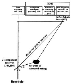
[0017] Fig. 2 illustrates a schematic diagram of an exemplary
apparatus useful for performing the process of the present
invention;
[0018] Fig. 3 illustrates a flow chart of operations for an
exemplary embodiment of the invention;
CA 02485761 2004-10-22
-6-
[0019] Fig. 4 is a graph of a lateral resolution as defined by
Fresnel Zone radius for surface source and resonance scattering
as observed by receivers in VSP geometry; and
(0020] Figs. 5A, 5B and 5C show resonance spectra amplitude for
reservoir models with different lateral scale length.
[0021] It will be noted that throughout the appended drawings,
like features are identified by like reference numerals.
Detailed Description of the Invention
[0022] When conducting exploration in accordance with seismic
methods, reservoir zones are often characterized by strong
perturbations in elastic parameters, in particular compressional
wave velocities. Lateral variations of compressional and shear
wave velocities may be determined in the forward scattering
(transmission) direction using 3-C VSP data acquisition
geometry. Such an analysis of the transmitted seismic wavefield
helps to assess how well log data relate to the surrounding
reservoir zone.
[0023] As will be understood to persons of ordinary skill in the
art, the effects of heterogeneities on seismic wave propagation
can be described in terms of different propagation regimes (Wu,
1989): quasi-homogeneous for heterogeneities too small to be
seen by seismic waves, Rayleigh scattering, Mie scattering and
small-angle scattering. These scattering regimes cause
characteristic amplitude, phase and travel time fluctuation,
which can be used to obtain estimates of scale length and
thereby assess lateral continuity of lithological units and
structure in the immediate vicinity of boreholes.
CA 02485761 2004-10-22
_7_
[0024] Horizontal resolution of exploration seismic data is
often discussed in terms of the Fresnel Zone. For surface and
VSP data, the Fresnel Zone radius increases with increasing
depth of investigation. The lateral resolution scale obtained
from resonance scattering in accordance with the present
invention, however, is limited only by the effective frequency
content of the seismic signal.
[0025]In accordance with the operation of the invention in an
exemplary embodiment depicted in Fig. 2, seismic sources at the
surface generate seismic energy (compressional and shear wave
energy). Part of the seismic energy propagates through the
earth to a 3-C receiver in a borehole (i.e. along a direct path)
and part of the energy encounters a small-scale heterogeneity in
the proximity of the borehole. As such, scattered energy also
propagates to and will be recorded at the 3-C receiver.
[0026] Thus, Fig. 2 illustrates schematically and on location at
a volume of earth to be seismically explored an exemplary system
100 adapted for performance in accordance with a method aspect
of the present invention. System 100 comprises seismic sources
102, sensors 104, data acquisition equipment 106 and a data
processing system 108.
[0027] Seismic sources 102 may comprise any broadband controlled
(repeatable) sources such as vibroseis, explosives, airguns and
water guns, sparker, weight-drop, etc. Seismic sources 102 may
be located at or beneath the surface of the earth in the region
of the volume of the earth to be explored. Sensors 104
preferably comprise at least 3--C geophones or accelerometers. It
is noted that omni-directional sensors such as hydrophones
(detectors sensitive to pressure changes) are not generally
CA 02485761 2004-10-22
_g_
suitable to produce 3-C signal data. Sensors may be positioned
in the borehole in accordance with known techniques for
gathering 3-C VSP data. Single 3-C receivers or multiple 3-C
receiver arrays may be used. The resonance scattering technique
in accordance with the present invention is suitable for zero-
offset VSPs, walk-away VSPs, azimuthal VSPs and walk above VSPs
in vertical or deviated boreholes. As such the seismic sources
102 and sensors 104 may be positioned accordingly.
[0028] Data acquisition equipment 106 may comprise amplifiers,
filters, analog to digital signal conversion and seismic data
recording equipment for measurement of elastic waves
(compressional and shear waves) excited by broadband seismic
sources 102 at or beneath the surface with single- or multilevel
3 -C sensors 104 as described above . 3 -C sensors [ 104 ] and data
acquisition equipment [106] may be separated by wireline or may
be collocated. The resonance scattering technique requires full
waveform seismic data (including direct (down going), reflected
(up going) and scattered arrivals). Thus true amplitude 3-C
recordings are preferably utilized. Data acquisition equipment
106 preferably records the signal data it acquires to a computer
readable medium such as disk, tape or other device (not shown).
[0029] Data processing system 108 may comprise a microcomputer
programmed in accordance with the method aspect of the invention
to perform resonance scattering processing operations. Data
processing system 108 comprises, in this exemplary embodiment,
at least one processor 109 adapted for 3-C data signal
processing in accordance with a method described further herein
with reference to Fig. 3, such as by software programming or
other configuration techniques; one or more resonance scattering
visualization devices 110 (such as a display screen and/or
CA 02485761 2004-10-22
-9-
printer); and a data integration sub-system 111 including a
relational data base with complimentary information. Data
processing system 108 typically includes one or more input
devices such as a pointing device, keyboard or other device for
interacting with the system 108 (all not shown). Data system 108
may be coupled to data acquisition equipment 106 as per Fig. 2
for directly receiving acquired signal data from this equipment
106 or may receive it through other means such as via recorded
media or a network (all not shown). Many alternate embodiments
of data processing system 108 may be used. While the data
processing system 108 is shown including data integration sub-
system 111, persons skilled in the art will appreciate that such
a sub-system 111 may be remotely located and coupled via a
network or other connection. Further, various display or other
visualization devices may be used or coupled remotely to system
108. System 108 (i.e. processor 109) may produce resonance
scattering analysis data for visualisation on a visualisation
device coupled to a different data processing system (not
shown) .
[0030] Signal processing (for example, by data acquisition
equipment 106) is preferably restricted to adaptive noise
removal and instrument response de-convolution. The resonance
scattering technique of the present invention works well when
applied to raw (unconditioned) 3-C seismic data; however, some
seismic data processing techniques that are commonly applied to
raw data before it is examined may adversely affect this
resonance scattering method. Wiener filters (spike and
predictive convolution techniques) and conventional VSP
wavefield separation techniques are preferably not applied to
the signals for resonance scattering analysis.
CA 02485761 2004-10-22
- 1~ -
[0031] Referring now to Fig. 3 there is shown a flow chart of
operations 150 for an exemplary embodiment of a method aspect of
the present invention. Such operations may be performed by a
computer programmed in accordance with programming techniques
known to those of ordinary skill in the art to implement the
present invention as described herein above.
(0032]For each depth interval of interest and availability in a
set of true amplitude 3-C VSP data, at step 152, the 3-C VSP
data is rotated into the ray coordinate system. One component of
the three, the ray component, is rotated to point into the
direction of the incident pressure wave.
[0033] Windowing of the first arrival signal (compressional wave)
is performed on the radial component (that is, the component
that points in the direction of the ray) (step 154).
[0034] At step 156, further windowing is performed for the
signals on the other two (i.e. transverse) directional
components while using the same time window applied to the first
(radial) component. The signals thus share a time component but
have respective transverse directional components.
[0035] At step 158, a tapering of signals is preferably
performed in order to prevent discontinuities at the edges of
the window. Tapering may be performed in accordance with
Gaussian taper techniques.
[0036] Amplitude spectra for each of the 3-C VSP data is computed
(step 160) such as by the use of a fast Fourier transform. At
step 162, resonance spectra for the two transverse directions
are obtained by dividing respectively the two transverse
CA 02485761 2004-10-22
- 11 -
amplitude spectra components by the radial amplitude spectra
component.
[0037]The operations 150 are repeated in accordance with the
various time/depth parameters of the signal data captured to
create a multidimensional map of resonance spectra for the
volume of earth that is the subject of the seismic exploration.
[0038] Resonance spectra obtained at step 162 characterises
lateral heterogeneity in the vicinity of the sensors. Resonance
spectra obtained from the two transverse components detect small
scale heterogeneities in the proximity of the borehole: Signal
processing as described in steps 152 to 162 for first arrival
compressional waves may also be applied to first arrival shear
waves.
[0039] Resonance spectra from the map of such generated data may
then be integrated with well log, petrophysical and other
seismic data using, for example, data integration sub-system 111
to build an enhanced three dimensional geological computerized
model around the borehole in accordance with data integration
techniques known to those skil led in the art . Data generated in
accordance with the resonance scattering method described herein
may be used to enhance the accuracy and/or scope of these models
and the charts, graphs, tables, and other visualisations that
may be generated therefrom. In accordance with known techniques,
the resonance scattering data may be displayed for further
analysis and interpretation. The data may be displayed in
various horizontal and vertical time and depth slices.
[0040]The size of a heterogeneity detected may be determined by
dividing an estimated velocity of the seismic wave used to
CA 02485761 2004-10-22
-12-
generate the seismic data by the peak frequency of the amplitude
spectra. Velocity may be estimated using known techniques and
knowledge of the medium being explored. Further, proximity of a
heterogeneity may be determined using a wavelength of the peak
frequency of the amplitude spectra. The heterogeneity will be
within a distance less than 2 to 3 times the length of
wavelength. This is a reasonable assumption due to the rate at
which a scattered wave decays with distance. Direction is
easily determined using the known location of the sensor and the
seismic source.
[0041] As noted previously, in contrast to prior art techniques,
the lateral resolution scale obtained for resonance scattering
is limited only by the effective frequency content of the
seismic signal and not in terms of the Fresnel Zone radius. Fig.
4 shows the lateral resolution for resonance scattering
(obtained from forward scattered wavefield data) and radius of
Fresnel zone for surface sources having model parameters: v -
2400 m/s, fmin - 20 Hz and fmax - 120 Hz. For surface seismic
sources, the radius of the Fresnel zone increases with
increasing depth of investigation. In contrast, the radius of
investigation for resonance scattering analysis is controlled by
the effective bandwidth of the seismic signal and remains
constant at depth. Thereby resonance scattering analysis closes
the resolution gap between conventional well logs (decimetre
resolution) and surface seismic methods (hundred(s) of meters).
[0042] Figs. 5A, 5B and 5C show resonance spectra for three
synthetic reservoir models. The spectra are computed for
seismic frequencies from 20 to 120 Hz. The vertical scale length
for all models is 50 m and the models can be tied to an existing
borehole log; the horizontal scale of the reservoir model has a
CA 02485761 2004-10-22
-13-
correlation length of 2000m (Fig. 5A), 500m (Fig. 5B) and 50m
(Fig. 5C). As expected, seismic waveform data for models with
large horizontal scale length show no evidence of resonance
scattering (Fig. 5A, 5B). For short wavelength horizontal scales
lengths, prominent resonance peaks are observed in the resonance
spectra (Fig. 5C).
[0043] Resonance scattering analysis of 3-C VSP data detects
evidence for local anomalous physical properties in proximity of
the borehole. Although well suited to hydrocarbon and mineral
exploration, this borehole seismic technique is readily
adaptable to geotechnical and environmental problems such as
detection of local cavities, faults or fractures,
heterogeneities in foundations and tunnels. This is a
fundamental consequence of the underlying physics of this
method, which ultimately rests on local contrasts in physical
material properties (such as densities, compressional modulus or
shear modulus) .
[0044] Although the above description relates to specific
embodiments as presently contemplated by the inventors, it is
understood that the invention in its broad aspect includes
mechanical and functional equivalents of the elements described
herein. The embodiments) of the invention described above
is(are) intended to be exemplary only. The scope of the
invention is therefore intended to be limited solely by the
scope of the appended claims.