Note: Descriptions are shown in the official language in which they were submitted.
CA 02490105 2004-12-20
WO 2004/001455 PCT/AU2003/000770
- 1 -
A DATA ACQUISITION UNIT, SYSTEM AND
METHOD FOR GEOPHYSICAL DATA
Field of the Invention
The present invention relates to a data acquisition unit, system and method
for
geophysical data and, in particular, to such a data acquisition unit, system
and method
for use in geophysical surveys arranged to measure electric and/or magnetic
fields and
generate survey data on the basis of the measured field.
Background of the Invention
It is known to provide a data acquisition system which includes a plurality of
networked
data acquisition units, each data acquisition unit being connected to at least
one sensor
and being arranged to gather survey data from the sensors. The received survey
data is
passed via the network to a central computing device for processing.
Synchronisation of
the received survey data is also carried out via the network.
However, a disadvantage of this arrangement is that the gathered survey data
often
2 0 includes a significant amount of noise which can be of sufficiently large
magnitude to
obscure the desired signal response associated with a relatively deeply buried
target.
In the claims which follow and in the preceding description of the invention,
except
where the context requires otherwise due to express language or necessary
implication,
2 5 the word "comprise" or variations such as "comprises" or "comprising" is
used in an
inclusive sense, i.e. to specify the presence of the stated features but not
to preclude the
presence or addition of further features in various embodiments of the
invention.
Summary of the Invention
In accordance with a first aspect of the present invention, there is provided
a data
acquisition system for gathering geophysical data, said system comprising:
CA 02490105 2004-12-20 PCTlAU2003l000770
Received 17 September 2004
- 2 -
at least one data acquisition unit connectable to a plurality of sensors and
being
arranged, during use, to simultaneously gather geophysical data from the
sensors, the or
each data acquisition unit comprising time referencing means arranged to
generate time
reference data usable to control the time at which samples of geophysical data
are taken;
and
means for calculating spatial derivatives between simultaneous samples
associated with adjacent sensors connected during use to the at least one data
acquisition
unit so as to provide processed geophysical data with less noise.
l0 Preferably, the time referencing means includes a GPS receiver.
Alternatively or in
addition, the time referencing means may include an accurate oscillator,
preferably a
precision oven controlled crystal oscillator, and a counter arranged to count
signals
generated by the oscillator.
In embodiments which include an oscillator, the data acquisition unit is
preferably
arranged to receive synchronisation signals useable by the processing means to
adjust
the frequency of the oscillator and adjust the times at which samples of
geophysical data
are taken so that the times at which samples of geophysical data are taken are
synchronised with the times at which samples of geophysical data are taken in
other data
2 0 acquisition units.
Preferably, the data acquisition unit is arranged to receive programs and to
store the
programs in the data storage means for subsequent execution by the processing
means.
2 5 Preferably, the data acquisition unit is arranged to calculate an average
sample value for
a plurality of corresponding repeat sample values when a plurality of data
gathering
operations are carried out as part of a geophysical survey so as to reduce the
effect of
interference on the samples and reduce the quantity of data. The data
acquisition unit
may be arranged to compare repeat samples and to discard samples which differ
by a
3 0 predetermined amount from the majority of the repeat samples.
Preferably, the data acquisition unit is arranged to calculate an average
sample value for
a plurality of consecutive samples taken during a data gathering operation
carried out as
H:\jnelson\keep\retype\FP18004 PCT - A DATA ACQUISITION UNIT, SYSTEM AND
METHOD FOR GEOPHYSICAL DATA
- PGS 2, 6, 7, 27, 32. 36.doc
~VI~~IaED SHEET
6P~i:-.J
CA 02490105 2004-12-20
WO 2004/001455 PCT/AU2003/000770
- 3 -
part of a geophysical survey so as to produce a representative sample for the
consecutive
samples.
Preferably, the data acquisition unit is arranged to estimate the amount of
interference
present at a survey site. The amount of interference present may be estimated
by
carrying out a first data gathering operation with an incident magnetic field
of a first
polarity so as to produce a first response, carrying out a second data
gathering operation
with an incident magnetic field of a second polarity so as to produce a second
response,
and calculating the sum of the first and second responses so as to cause the
first and
second responses to cancel out.
Preferably, the data acquisition unit is arranged to filter gathered
geophysical data so as
to remove periodic interference.
Preferably, the data acquisition unit is arranged to convert gathered
geophysical data
into frequency domain using Fourier transform analysis.
Preferably, the data acquisition unit is arranged to generate a least one
quality control
indicator for use in assessing the quality of the gathered geophysical survey
data.
Preferably, the data acquisition unit is arranged to calculate a standard
deviation value
for the gathered geophysical survey data.
Preferably, the data acquisition unit is arranged to adjust the level of gain
applied to
2 5 gathered geophysical survey data based on an assessment of the magnitude
of the
gathered geophysical survey data.
Preferably, the system is arranged to downward extrapolate gathered
geophysical survey
data so as to enhance detail of a target located below the surface of a survey
area.
Preferably, the data acquisition unit is connectable to an energy source and
the data
acquisition unit is operable as an energy source control unit.
CA 02490105 2004-12-20
WO 2004/001455 PCT/AU2003/000770
- 4 -
Preferably, the data acquisition unit includes at least one interface arranged
to facilitate
transfer of processed geophysical data and/or programs to or from the data
acquisition
unit. For this purpose, the interface may include an infra red interface, a
serial interface
and/or a network interface. The interface may be of a type which utilises
wireless
protocols, such as Bluetooth.
In embodiments which include an oscillator, a synchronisation interface may be
provided for facilitating transfer of synchronisation signals to and/or from
the data
acquisition unit for the purpose of ensuring correct synchronisation of the
oscillator with
oscillators of other data acquisition units.
Preferably, the data acquisition unit includes display means, which may be an
LCD
display and/or an LED display, arranged to provide information to an operator
as to
whether operation of the data acquisition unit is satisfactory and/or whether
the
processed survey data is of sufficient quality for subsequent analysis. Such
information
may indicate whether there is a fault with the data acquisition unit or with a
sensor
connected to the data acquisition unit, or whether other conditions exist
which
necessitate operator action.
Preferably, the data acquisition unit is arranged to store a correction
coefficient for each .
sensor connected during use to the data acquisition unit, each correction
coefficient
being used to correct for variations in sensor sensitivity.
2 5 Preferably, the data storage means is a FLASH memory. Additionally, a hard
disk drive
may be provided.
Preferably, the system includes a plurality of data acquisition units.
3 0 In one arrangement, the data acquisition unit includes the means for
calculating spatial
derivatives.
CA 02490105 2004-12-20
WO 2004/001455 PCT/AU2003/000770
- 5 -
In an alternative arrangement, the means for calculating spatial derivatives
is separate to
the data acquisition unit. With this arrangement, the system may further
comprise a
portable computing device, the portable computing device including the means
for
calculating spatial derivatives.
Preferably, the system further comprises at least one reference data
acquisition unit,
each reference data acquisition unit being connectable to at least one
reference sensor
and being arranged, during use, to gather geophysical data from the at least
one
reference sensor, and to take samples of the geophysical data gathered from
the sensors;
wherein the means for calculating spatial derivatives between samples
associated with
adjacent sensors is arranged to calculate first spatial derivatives between at
least some of
the sensors connected to the data acquisition units and a reference sensor
connected to
the reference data acquisition unit during a first data gathering operation
when the
sensors are disposed in a first location, to calculate second spatial
derivatives between at
least some of the sensors connected to the data acquisition units and a
reference sensor
connected to the reference data acquisition unit during a second data
gathering operation
when the sensors are disposed in a second location, and to calculate a
difference spatial
derivative between the first and second spatial derivatives, each said
difference spatial
derivative being indicative of a spatial derivative between a sensor disposed
in a first
2 0 location and a sensor disposed in a second location.
Preferably, the system further comprises means for calculating an integral of
the spatial
derivatives so as to produce conventional geophysical data with less noise.
2 5 In one arrangement, the system also includes an energy source arranged to
generate and
direct energy towards the sub-surface volume so as to cause a geophysical
response and
thereby cause generation of the geophysical signals.
Preferably, the energy source includes a transmitter and a transmitter loop.
Preferably, the system is arranged to correct for variations in magnitude of
the
transmitter current during a geophysical survey. The system may be arranged to
correct
CA 02490105 2004-12-20 pCT/AU2003/000770
Received 17 September 2004
- 6 -
for a variation in magnitude of the transmitter current caused by a variation
in power
supplied to transmitter.
Preferably, the system also includes an energy source control unit connectable
to the
energy source and arranged to gather output data from the energy source, the
energy
source control unit including:
time referencing means arranged to generate time reference data usable to
control the time at which gathering of the energy source output data occurs
and to
associate the energy source output data with the time reference data; and
data storage means for storing the energy source output data.
Preferably, the energy source control unit is a transmitter control unit
arranged to control
a transmitter so as to energise a transmitter loop in accordance with a
predetermined
frequency.
Preferably, the energy source control unit includes the same components as the
data
acquisition unit so that the transmitter control unit is capable of carrying
out the
functions of the data acquisition unit and vice versa.
2 0 Preferably, the system is arranged to correct for variations in magnitude
of the
transmitter current during a geophysical survey. The system may be arranged to
correct
for a variation in magnitude of the transmitter current caused by a reduction
in power
supplied to the transmitter.
2 5 In accordance with a second aspect of the present invention, there is
provided a method
of acquiring geophysical data, said method including the steps of
providing at least one data acquisition unit arranged to simultaneously gather
geophysical data from a plurality of sensors connected in use to the at least
one data
acquisition unit;
3 0 connecting at least one geophysical sensor to the at least one data
acquisition
unit;
generating at the data acquisition unit time reference data usable to control
the
H:\jnelson\keep\retype\FP18004 PCT - A DATA ACQUISITION UNIT, SYSTEM AND
METHOD FOR GEOPHYSICAL DATA
- PGS 2, 6, ~, 27, 32, 36.doc
64ME~fi~ED SHEET
1P~"v'n:J
CA 02490105 2004-12-20 ~ r~c:T/AUZ.oo3ioo0770
Received 17 September 2004
time at which gathering of samples of geophysical data are taken; and
calculating spatial derivatives between simultaneous samples associated with
adjacent sensors connected during use to the at least one data acquisition
unit so as to
produce processed geophysical data with less noise.
Preferably, the method further comprises the steps of:
providing at least one reference data acquisition unit arranged, during use,
to
gather geophysical data from the at least one reference sensor;
connecting each reference data acquisition unit to at least one reference
sensor ;
calculating first spatial derivatives between at least some of the sensors
connected
to the data acquisition units and a reference sensor connected to the
reference data
acquisition unit during a first data gathering operation when the sensors are
disposed in
a first location;
calculating second spatial derivatives between at least some of the sensors
connected to the data acquisition units and a reference sensor connected to
the reference
data acquisition unit during a second data gathering operation when the
sensors are
disposed in a second location; and
calculating a difference spatial derivative between the first and second
spatial
derivatives, each said difference spatial derivative being indicative of a
spatial
2 0 derivative between a sensor disposed in a first location and a sensor
disposed in a
second location.
Preferably, the method further comprises means for calculating an integral of
the spatial
derivatives so as to produce conventional geophysical data with less noise.
Preferably, the method further includes the step of correcting variations in
the energy
source using the reference data acquisition unit and associated reference
sensor.
Preferably, the time referencing means includes a GPS receiver. Alternatively
or in
3 0 addition, the time referencing means may include an oscillator, preferably
, a precision
oven controlled crystal oscillator, and a counter arranged to count signals
generated by
oscillator.
H:\jnelson\keep\retype\FP18004 PCT - A DATA ACQUISITION UNIT, SYSTEM AND
METHOD FOR GEOPHYSICAL DATA
- PGS 2, 6, 7, 27, 32, 36.doc
I~MENDED SHEET
IPEAhJ
CA 02490105 2004-12-20
WO 2004/001455 PCT/AU2003/000770
_ g
In embodiments which include an oscillator, the method preferably includes the
step of
receiving at the data acquisition unit synchronisation signals useable by the
processing
means to adjust the frequency of the oscillator and thereby adjust the time at
which
gathering of geophysical data occurs so that the time at which gathering of
geophysical
data occurs is synchronised with the time at which gathering of geophysical
data occurs
in other data acquisition units.
Preferably, the method further comprises the step of calculating an average
sample value
for a plurality of corresponding repeat sample values when a plurality of data
gathering
operations are carried out as part of a geophysical survey so as to reduce the
effect of
interference on the samples and reduce the quantity of data.
Preferably, the method further comprises the step of comparing repeat sample
values
and discarding samples which differ by a predetermined amount from the
majority of
the repeat sample values.
Preferably, the method fizrther comprising the step of calculating an average
sample
value for a plurality of consecutive samples taken during a data gathering
operation
carned out as part of a geophysical survey so as to produce a representative
sample for
2 0 the consecutive samples.
Preferably, the method further comprises the step of estimating the amount of
interference present at a survey site. The amount of interference present may
be
estimated by carrying out a first data gathering operation with an incident
magnetic field
2 5 of a first polarity so as to produce a first response, carrying out a
second data gathering
operation with an incident magnetic field of a second polarity so as to
produce a second
response, and calculating the sum of the first and second responses so as to
cause the
first and second responses to cancel out.
3 0 Preferably, the method further comprises the step of filtering gathered
geophysical data
so as to remove periodic interference.
CA 02490105 2004-12-20
WO 2004/001455 PCT/AU2003/000770
_ g _
Preferably, the method further comprises the step of converting gathered
geophysical
data into frequency domain using Fourier transform analysis.
Preferably, the method further comprises the step of correcting for variations
in
magnitude of the energy source during a geophysical survey. The step of
correcting for
variations in magnitude may include the step of correcting for a variation in
magnitude
of the energy source caused by a variation in power supplied to the energy
source.
Preferably, the method further comprises the step of generating a least one
quality
control indicator for use in assessing the quality of the gathered geophysical
survey data.
Preferably, the method further comprises the step of calculating a standard
deviation
value for the gathered geophysical survey data.
Preferably, the method further comprises the step of adjusting the level of
gain applied
to gathered geophysical survey data based on an assessment of the magnitude of
the
gathered geophysical survey data.
Preferably, the method further comprises the step of downward extrapolating
gathered
2 0 geophysical survey data so as to enhance detail of a target located below
the surface of a
survey area.
Preferably, the method further includes the step of facilitating transfer of
processed
geophysical data and/or programs to or from the data acquisition unit. For
this purpose,
2 5 the interface may include an infra red interface, a serial interface
and/or a network
interface.
In embodiments which include an oscillator, the method may also include the
step of
facilitating transfer of synchronisation signals to and/or from the data
acquisition unit
3 0 for the purpose of ensuring correct synchronisation of the oscillator with
oscillators of
other data acquisition units.
CA 02490105 2004-12-20
WO 2004/001455 PCT/AU2003/000770
- 10 -
Preferably, the method further includes the step of providing display means
for
providing information to an operator as to whether operation of the data
acquisition unit
is satisfactory and/or whether the time-stamped processed survey data is of
sufficient
quality for subsequent analysis. Said information may indicate whether there
is a fault
with the data acquisition unit or with a sensor connected to the data
acquisition unit, or
whether other conditions exist which necessitate operator action.
Brief Description of the Drawings
The present invention will now be described, by way of example only, with
reference to
the accompanying drawings, in which;
Figure 1 is a block diagram of a data acquisition system in accordance with an
embodiment of the present invention;
Figure 2a and 2b are plots of modelled fixed-loop TEM responses of a target
for
X and Z components respectively;
Figure 3 is a block diagram of a data acquisition unit in accordance with an
embodiment of the present invention;
Figure 4 is a diagrammatic representation of an array of data acquisition
units
deployed in a survey area during use;
2 0 Figure Sa and Sb are diagrammatic representations illustrating a method of
using
a relatively small number of data acquisition units to carry out a survey over
a relatively
large survey area;
Figure 6 is a block diagram of an interface unit of the data acquisition unit
shown in Figure 3; and
2 5 Figure 7 is a block diagram of a data acquisition system in accordance
with an
alternative embodiment of the present invention.
Description of a Preferred Embodiment of the Present Invention
3 0 Referring to Figure 1 of the drawings, there is shown a data acquisition
system 10 for
gathering geophysical data during a geophysical survey. In this example, the
system 10
is a TEM (transient electromagnetics) type system arranged to generate and
sense
CA 02490105 2004-12-20
WO 2004/001455 PCT/AU2003/000770
- 11 -
magnetic fields, although it will be understood that the invention is equally
applicable to
other geophysical surveys, such as geophysical surveys based on electric
fields or
seismic measurements, including MT (magneto-telluric) and IP (induced
polarisation)
type surveys.
An example of responses obtained from a modelled fixed-loop TEM type survey
for a
conductive target disposed at a depth of the order of 500 m is shown in
Figures 2a and
2b, where Figure 2a shows a profile for an X component of a response and
Figure 2b
shows a profile of a Z component of the response. The responses are displayed
in units
of microvolts per transmitter amp for coil sensors of effective area 10,000
sqm. At
delay times greater than 250 mS, that is 250 mS after deactivation of the
transmitter
current, the target becomes identifiable as a polarity reversal 19 in the Z
component and
a peak 21 in the X component at a location approximately above the target. As
can be
seen, a target is not identifiable until the responses have decayed to around
10 nV/A.
Accordingly, in order to detect such a target at a depth of the order of 500 m
using a
TEM type survey, the noise level associated with the system must be
significantly less
than 10 nV/A so that the response is not obscured by noise.
The system 10 includes a source of energy, in this example in the form of a
pair of
2 0 transmitter loops 12, each transmitter loop 12 generating a magnetic field
when an
electrical current passes through the loop 12. The magnetic field generated by
a
transmitter loop 12 passes into the earth's sub-surface and induces currents
in
electrically conductive components in the sub-surface which in turn generate
electro-
magnetic fields. The transmitter current is turned off after a predetermined
period of
2 5 time which causes the electro-magnetic fields to decay in magnitude over
time. The
decaying electro-magnetic fields are sensed by a plurality of data acquisition
units 14
and associated sensors 15 disposed around the desired area 17 to be surveyed,
and the
sensed survey data is then sampled at a predetermined sampling rate so as to
produce for
each sensor samples of electro-magnetic field data which decrease in magnitude
with
3 0 each successive sample. The data samples are stored at the data
acquisition unit 14. By
analysing the data samples received at the data acquisition units 14, it is
possible to
obtain an indication as to the characteristics of the desired sub-surface
volume. In
CA 02490105 2004-12-20
WO 2004/001455 PCT/AU2003/000770
- 12 -
practice, the transmitter loops 12 are energised one at a time and the
response data from
both transmitter loops is analysed to provide an indication as to the
characteristics of the
desired sub-surface volume.
In this example, the sensors 15 are coil-type sensors configured so as to
measure a Z
component, that is a generally vertical component, of an electro-magnetic
field. Each
coil has a passive coil area of the order of 350 sqm. It is possible to
construct such a
coil which has relatively low noise characteristics at frequencies of the
order of 10 Hz.
The system 10 also includes an energy source control unit, in this example a
transmitter
control unit 16, and a transmitter 18, the transmitter control unit 16 being
arranged to
control the transmitter 18 so as to energise the transmitter loops 12 in
accordance with a
predetermined frequency. The transmitter control unit 16 also serves to sample
the
transmitter current at predetermined intervals corresponding to the sampling
rate in the
data acquisition units 14 and to store the transmitter current samples at the
transmitter
control unit 16. This may be facilitated in any suitable way, for example by
disposing a
shunt resistor in series with the transmitter current.
The data acquisition units 14 are each arranged to generate time reference
data useable
2 0 to control the times at which samples of the survey data are taken.
Likewise, the
transmitter control unit 16 is arranged to generate time reference data
useable to control
the times at which samples of the transmitter current are taken.
In this example, the transmitter control unit 16 and each data acquisition
unit 14 include
2 5 the same components and, as a consequence, the data acquisition units 14
are able to
function as a transmitter control unit 16 and vice versa. For ease of
reference, in the
following description of embodiments of the invention, the data acquisition
units 14 and
the transmitter control unit 16 will be referred to as "nodes".
3 0 However, notwithstanding that the data acquisition units 14 and the
transmitter control
unit 16 in the following embodiments include the same components, it will be
understood that this is not necessarily the case. As an alternative, the data
acquisition
CA 02490105 2004-12-20
WO 2004/001455 PCT/AU2003/000770
- 13 -
units 14 and the transmitter control unit 16 may be configured so as to be
dedicated to
their respective tasks and, as a result, not interchangeable.
The structure of a node 14, 16 is shown in Figure 3.
Each of the nodes 14, 16 includes circuitry 20 and a power source, in this
example in the
form of a rechargeable battery 22. As an alternative, power may be supplied
from an
external power source.
The circuitry 20 includes a processing and control unit 26 for processing
survey data
received from sensors connected in use to the node when the node is used as a
data
acquisition unit 14, for processing transmitter current waveform data received
from the
transmitter 18 when the node is used as a transmitter control unit 16, and to
control and
coordinate operation of the node 14, 16. The circuitry 20 also includes an
analogue
interface unit 28 for interfacing between the processing and control unit 26
and sensors
15 or a transmitter 18 connected in use to the node 14, 16, and a circuit
protection unit
30 for protecting the analogue interface unit 28 from damage which may occur
as a
result of large voltage transients from the sensors 1 S.
2 0 It will be understood that the type of sensors used will depend on the
particular type of
geophysical survey operation being carried out. In the present example, the
survey is a
TEM type survey and the sensors are coil-type sensors.
The circuitry 20 also includes an input/output interface 36 arranged to
facilitate transfer
2 5 of information between the node 14, 16 and a separate computing device or
between
two nodes 14, 16. In this example, the input-output interface 36 includes a
serial
interface for facilitating transfer of synchronisation signals to the nodes
14, 16 for the
purpose of maintaining synchronisation of sample times, and an infra red
interface for
facilitating transfer of geophysical survey data or transmitter current data
between the
3 0 node 14, 16 and a separate computing device using infra red radiation. In
this example,
the infra red interface is an IrDA interface. The input/output interface may
also include
a network interface (not shown). The input/output interface may as an
alternative be of
CA 02490105 2004-12-20
WO 2004/001455 PCT/AU2003/000770
- 14 -
a type which utilises wireless protocols, such as Bluetooth.
The circuitry 20 also includes a transmitter interface 38 for use when the
node operates
as a transmitter control unit 16. The transmitter interface 38 serves to
transfer control
instructions to the transmitter 18 and may also be used to transfer current
waveform data
from the transmitter 18 to the processing and control unit 26 for sampling.
The circuitry 20 also includes an LCD display 40 for displaying to a user
information
indicative of the status of operation of the node 14, 16, a user control panel
42 for
facilitating direct entry of control instructions to the node 14, 16 by a
user, and an LED
display 44 which serves to indicate to a user the status of the node 14, 16,
whether the
node 14, 16 has a fault, whether the remaining power in the battery 22 is low,
and so on.
The processing and control unit 26 receives signals indicative of timing and
location
data from a GPS antenna 32 and generates time reference data which governs the
time at
which samples of the survey data or the transmitter current are taken.
The processing and control unit 26 includes a processor 46, and a timing unit
48 in
operative communication with the GPS antenna 32 and arranged to generate the
time
2 0 reference data using the signals received from the GPS antenna 32.
In the case of a data acquisition unit 14, the time reference data is used to
control the
times at which samples of gathered survey data received from the sensors 15
are taken.
In the case of a transmitter control unit 16, the time reference data is used
to control the
2 5 times at which samples of the transmitter current are taken. By
associating the time
reference data with the samples of the received survey data and the samples of
the
transmitter current, the system 10 is able to accurately synchronise the
transmitter
current with the received survey data.
3 0 The processing and control unit 26 also includes a data storage device 54
arranged to
store survey data received from sensors 15 connected to the data acquisition
unit 14 or
to store transmitter current data received from the transmitter 18, depending
on whether
CA 02490105 2004-12-20
WO 2004/001455 PCT/AU2003/000770
- 15 -
the node is a data acquisition unit 14 or a transmitter control unit 16. The
data storage
device 54 is also used to store programs for controlling operation of the node
14, 16. In
the present example, the data storage device 54 is in the form of a FLASH
memory
The processor 46 is arranged to control and coordinate all operations in the
node 14, 16
in accordance with programs stored in the data storage device 54. It will be
understood
that the programs may be pre-stored on the data storage device 54 prior to
deployment
of the nodes on-site, or the programs may be transferred to the nodes as part
of the
deployment process by connecting a computing device to the node 14, 16 using
the
input-output interface 36 and transferring the programs to the node 14, 16 for
storage on
the data storage device 54. Such programs may in addition or alternatively be
located
on a separate computing device to which the survey data is to be transferred
for analysis.
The transferred programs are arranged to cause appropriate time reference data
to be
generated using signals received from the GPS antenna 32, and to associate the
time
reference data with the survey data samples or with the transmitter current
data samples
depending on whether the node operates as a data acquisition unit 14 or a
transmitter
control unit 16.
2 0 In the case of a data acquisition unit 14, the stored programs are also
arranged to cause
the processor 46 to process survey data received from sensors 1 S so as to
generate
processed survey data of reduced volume and reduced noise relative to the
received
survey data and which is in a more useful format. The processed survey data
together
with associated time reference data is stored on the data storage device 54.
Processing
2 5 functions may be carried out during and/or after data acquisition.
The stored programs may include programs arranged to detect the presence of a
transient
interference event such as an atmospheric discharge (lightning) or a surge on
a power
transmission line. Software enables a decision to be made as to which data has
been
3 0 affected by the transient interference and, for the data which has been
affected, a best
guess of the true data for the relevant sample period is generated to replace
the affected
data. This is achieved by carrying out a plurality of data gathering
operations in a
CA 02490105 2004-12-20
WO 2004/001455 PCT/AU2003/000770
- 16 -
survey with each data gathering operation involving activation of the
transmitter current
and gathering of data samples on deactivation of the transmitter current, and
comparing
each sample of a particular data gathering operation with a corresponding
sample of a
subsequent or previous data gathering operation, or with a corresponding
average
sample value of a plurality of corresponding samples taken during a plurality
of data
gathering operations. Since it is expected that the corresponding samples
should differ
only slightly from each other, if some of the sample values differ
significantly from a
previous, a subsequent or an average sample value, the software may be
arranged to
ignore the affected part of the survey data or to ignore all data gathered
during the
particular data gathering operation during which the affected survey data was
present.
The stored programs may include a stacking program arranged to increase the
signal-to-
noise ratio by carrying out selective tapered stacking as a method of
averaging long
series of raw data into smaller series in order to reduce the effects of
interference and to
reduce the data volume. Stacking is achieved by averaging a sample over a
large
number of repeat samples, that is, over a large number of data gathering
operations.
Repetitive data is significantly enhanced at the expense of non-repetitive
data. The
stacking program may be arranged such that the contribution to the stacked
data by each
element of the raw data varies depending on an assessment made by algorithms
in the
2 0 programs as to the quality of the elements. For example, if one or more
samples are
affected by a transient interference event, the identified samples may be
ignored by the
stacking program.
The stored programs may also include a windowing program arranged to increase
the
2 5 signal-to-noise ratio by averaging a number of consecutive samples taken
from each
sensor during a data gathering operation so as to produce a single
representative sample
value for the consecutive samples.
It will be understood that by carrying out selective tapered stacking and/or
by averaging
3 0 a number of consecutive samples, it is possible to reduce the noise
associated with
received survey data to levels of the order of 1 nV/A or less.
CA 02490105 2004-12-20
WO 2004/001455 PCT/AU2003/000770
- 17 -
The stored programs may also include programs arranged to generate and
continuously
update estimates of the incoming interference from all sources such as power
transmission lines, BLF transmitters, atmospheric sources, and so on. If
harmonic
interference is still detectable after stacking has taken place, the
interference can be
removed using a digital filter arranged to remove the affected parts of the
spectrum and
replace the affected spectrum with interpolated error-free spectra.
The degree of incoming interference may be detected in various ways. For
example,
two data gathering operations may be carried out with transmitter currents of
opposite
polarity and the responses added together so as to produce a representation of
the noise
only.
Any harmonic interference which is present in the survey data is in most cases
relatively
easy to detect as the frequency of the harmonic interference is generally at a
different
frequency to the frequency used for the transmitter 18. For example, harmonic
interference caused by power lines is generally at SOHz and can therefore be
removed
from the survey data by any appropriate filtering technique, such as digital
filtering.
The stored programs may also include a drift detector program arranged to
detect a drift
2 0 in relative timing between the node and the transmitter by cross-
correlating a
measurement at a site with a previous measurement obtained at the time of
deployment
of the node at the site. Using this detection, timing drift can be corrected.
The stored programs may also include programs arranged to cause the processor
46 to
2 5 convert waveforms corresponding to the received survey data into the
frequency domain
using Fourier transform analysis, and to convert data into meaningful units.
The stored programs may also include programs arranged to carry out
deconvolutions in
order to remove the effects of various phenomena which may occur during the
survey,
3 0 such as variations in transmitter waveforms and sensor properties for
example caused by
a gradual decrease in power supplied by the battery 22.
CA 02490105 2004-12-20
WO 2004/001455 PCT/AU2003/000770
- 18 -
The stored programs may also include programs arranged to calculate quality
control
indicators for use in assessing the quality of the received survey data. For
example, the
programs may be arranged to calculate standard deviation values for the survey
data
and, using noise indicators for example derived from the above described
estimate of the
noise present, to make a determination as to whether and/or which noise
reduction
process is necessary.
The stored programs may also enable the processor 46 to make decisions in
isolation
concerning parameters associated with survey data acquisition and processing.
For
example, the programs may enable the processor 46 to make decisions on the
level of
gain to apply to received survey data by analysing the magnitude of the survey
data
samples and adjusting the level of gain applied to the samples so as to
prevent saturation
of the amplifiers 60 during use.
Each of the nodes includes a multi-tasking operating system such as Linux
which
enables the node to carry out several functions simultaneously. While
acquiring data,
the node can be interrogated, for example using a hand-held computing device,
in order
for an operator to carry out quality control of the performance of the node.
Interrogation
of the nodes can be carried out without interrupting the acquisition and
processing of
2 0 data being performed by the nodes. Operators are able to download from the
node any
data stored in the data storage device 54, including information indicative of
the quality
of any data stored in the data storage device 54. In this example, transfer of
data
between a node and the hand-held computing device takes place via the infra
red
interface provided on the node and a corresponding infra red interface
provided on the
2 5 hand-held computing device, although it will be understood that the
transfer may take
place in any other suitable way, for example via the serial interface or via a
network
interface.
The computing device to which data is transferred from the nodes may include
stored
3 0 programs arranged to carry out processing operations on the survey data
received from
the nodes. Since fixed loop EM data can be treated like geomagnetic or gravity
data in
that it can be represented by potential field equations, it is possible to
extrapolate the
CA 02490105 2004-12-20
WO 2004/001455 PCT/AU2003/000770
- 19 -
data so as to provide estimates of the magnetic field above or below the
surface of the
survey area. For example, it is possible to interpolate the magnetic field so
as to
enhance detail of target elements located below the surface of the survey
area. The
interpolation process uses spatial derivatives derived between sensors
disposed on the
surface of the survey area to derive spatial derivatives in a vertical
direction.
The stored programs are also arranged to process the received surveyed data
samples
from the sensors so as to reduce noise of the type caused by atmospheric
discharges and
telluric currents. Such noise is generally relatively constant over a desired
survey area.
In order to separate such noise from the survey data, the stored programs are
arranged to
calculate the difference between simultaneous samples from adjacent sensors
and to
divide each difference value by the distance between the relevant sensors.
This is
equivalent to taking a spatial derivative over the survey data.
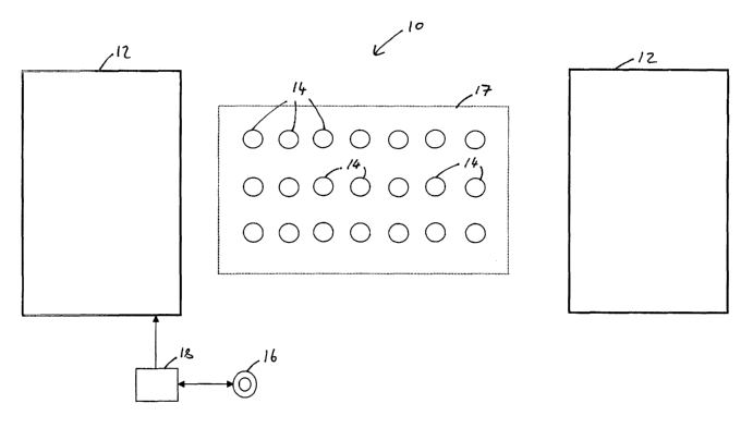
A representation of an array of data acquisition units 14 disposed on a survey
site is
shown in Figure 4.
It will be understood that calculations of spatial derivatives may be taken
between
2 0 sensors 15 disposed along a line in a first direction, for example between
first and
second sensors 15a and 15b respectively, between sensors 15 disposed along a
second
line orthogonal to the first line, such as between first and third sensors 15a
and 15c
respectively, and/or between sensors disposed generally diagonally relative to
each
other, such as between first and fourth sensors 15a and 15d respectively. The
important
2 5 aspect is that for each sensor 15 spatial derivatives may be taken between
the sensor 15
and any number of adjacent sensors 15.
It will be understood that by calculating spatial derivatives in this way, it
is possible to
derive processed survey data which is virtually free of noise caused by
atmospheric
3 0 discharges, telluric currents, and the like.
In some situations, it is not practically possible to calculate derivatives
simultaneously
CA 02490105 2004-12-20
WO 2004/001455 PCT/AU2003/000770
- 20 -
over an entire survey area because a large number of sensors 15 and associated
data
acquisition units 14 would be required and an insufficient number of data
acquisition
units 14 and sensors 15 are available. With such a situation, operators are
required to
move the available array of data acquisition units and sensors several times
in order to
cover the entire survey area. However, since all proposed locations in the
survey area
for the sensors 15 are not simultaneously occupied by the sensors 15, it is
not possible to
directly calculate all possible spatial derivatives for each sensor location
instantaneously.
In order to obtain spatial derivatives for all sensor locations, a reference
data acquisition
unit and associated reference sensor 1 Sr may be used, as shown in Figures Sa
and Sb. In
the present example, the reference sensor 15r is disposed generally centrally
of the
proposed survey area, although this is not necessarily the case.
As indicated in Figure Sa, in order to cover an entire survey area, a first
line 55 of data
acquisition units 14 and associated sensors 15 are first disposed in the
survey area.
Instantaneous spatial derivatives are then taken simultaneously between
adjacent nodes
in the first line 55, such as between first and second sensors 1 Sa and 1 Sb
respectively,
between second and third sensors 15b and 15c respectively and between each of
the
2 0 sensors in the first line 55 and the reference sensor 1 Sr. The sensors 15
in the first line
55 are then moved so as to be disposed in a second line 57, and simultaneous
spatial
derivatives between adjacent sensors 15 in the second line 57 and between each
sensor
15 in the second line 57 and the reference sensor 15r are taken. In order to
calculate the
instantaneous spatial derivative between a sensor 15 when placed in the first
line 55 and
2 5 an adjacent sensor 1 S when placed in the second line 57, the spatial
derivative
calculated relative to the reference sensor 14r when a sensor is in the second
line 57 is
subtracted from the spatial derivative calculated relative to the reference
sensor 14r
when the sensor is in the first line 55. This provides a spatial derivative
corresponding
to a simultaneous spatial derivative calculated between a sensor disposed in
the first line
30 55 and an adjacent sensor disposed in the second line 57.
Since all the spatial derivatives for the whole survey are not actually
derived from
CA 02490105 2004-12-20
WO 2004/001455 PCT/AU2003/000770
- 21 -
survey data gathered simultaneously, it may be necessary to correct the survey
data for
any variations which may occur as a result of variations in transmitter
current which
may occur between different sensor locations. The reference data acquisition
unit 14
may be used to facilitate correction of variations in the survey data by
continuously
measuring the survey data obtained by the reference node during the whole
survey.
It will be understood that in order to correct for small variations in
sensitivity of the
sensors 15 and the data acquisition units 14 prior to carrying out a survey,
the sensors 15
and data acquisition units 14 should be calibrated in order to correct for
variations
caused by differences in orientations of the sensors and sensitivity of the
sensors and
data acquisition units.
In the present example, this is achieved by collecting survey data in response
to a distant
signal source that is only slowly spatially varying over the survey area or
not varying at
all. For example, noise caused by distant atmospheric discharges may be used
as the
signal source and survey data collected in the absence of a transmitter
current. Given
the relatively small spatial separation of sensors in the survey area, it can
be expected
that the response at each sensor will be well correlated between all sensors.
For a given
survey area, a correction co-efficient may be associated with each sensor or,
in the case
2 0 of multiple component sensors, a vector or tensor may be associated with
each sensor.
The stored programs may also be arranged to integrate the survey data so as to
achieve
potentially cleaner conventional data. An integration constant may be added
which may
be derived using the reference data acquisition unit and associated reference
sensor.
The analogue interface unit 28, shown more particularly in Figure 6, includes
circuitry
for four different signal channels, each channel including an amplifier 60
which receives
survey data from a sensor 15 or from a transmitter 18 depending on whether the
node is
a data acquisition unit 14 or a transmitter control unit 16. The filtered data
is then
3 0 passed to a low-pass filter 62 and an A/D converter 64, in this example a
24-bit
converter.
CA 02490105 2004-12-20
WO 2004/001455 PCT/AU2003/000770
- 22 -
Control of the amplifiers 60, filters 62 and the A/D conveiters 64 including
clocking of
the A/D converters 64 and thereby sampling of the received survey data or the
transmitter current, is carried out by the processing and control unit 26.
The protection unit 30 includes a separate protection circuit for each
channel, each
protection circuit serving to protect the circuitry of the analogue interface
unit 28 from
damage due to large voltage transients which may be present on the signals
input to the
protection unit 30.
The nodes 14, 16 may also be provided with an accurate oscillator, in this
example an
oven-controlled crystal oscillator (OCXO), useable by the timing unit 48 to
generate
time reference data when a GPS signal is unavailable. The crystal oscillator
produces an
accurate frequency signal which is used by the timing unit 48 to generate time
reference
data. In this example, the time reference data is the output of a counter
arranged to
count the number of cycles of the signal produced by the crystal oscillator.
However,
with this arrangement, since each node 14, 16 includes a separate crystal
oscillator, if a
GPS signal is unavailable it is necessary to periodically synchronise the
crystal
oscillators with each other during the course of a survey. In practice, this
is achieved by
providing the transmitter control unit 16 with a high precision crystal
oscillator, by
2 0 providing each data acquisition unit 14 with a precision crystal
oscillator, and by
periodically connecting each data acquisition unit 14 with the transmitter
control unit 16
through the input/output interface 36 so as to compare the frequency of the
high
precision crystal oscillator with the frequency of the precision oscillator
and to compare
the phasing of the counter in the data acquisition unit with the phasing of
the counter in
2 5 the transmitter control unit 16. Any discrepancy between the frequencies
and counters
is removed by adjusting the frequency of the precision crystal oscillator and
by adjusting
the phasing of the counter associated with the precision crystal oscillator.
When a GPS signal is unavailable for an extended period of time of the order
of several
3 0 hours or more, there is a possibility that the time reference data derived
from the
oscillator will drift. During a survey with an active source, the drift of a
node's time
reference data relative to the source primary field waveform can be monitored
by a node
CA 02490105 2004-12-20
WO 2004/001455 PCT/AU2003/000770
- 23 -
whilst it is positioned at a particular location. The drift is calculated by
cross-
correlating a measurement at a particular time with a measurement taken at the
time of
deployment of the node at the location. Since it can be assumed that the drift
is caused
by a slow loss of synchronisation at the node, the drift can be corrected by
modifying the
frequency of the oscillator and phasing of the counter associated with the
oscillator in
accordance with the detected drift.
An example of a geophysical transient electromagnetic (TEM) survey using the
above
data acquisition system will now be described.
Operators first deploy one or more transmitter loops 12 at a suitable location
for
energising a desired survey area 80, and connect the transmitter 18 to a
transmitter loop
12. A transmitter control unit 16 is connected to the transmitter 18 in order
to control
the transmitter 18 and to sample the current flowing through the transmitter
loop 12.
Operators then distribute data acquisition units 14 around the desired survey
area and
connect each data acquisition unit 14 to one or more sensors 15, in this
example coil-
type sensors, by connecting the sensors 15 to the inputs of the protection
unit 30.
2 0 When deployed, the data acquisition units 14 and the transmitter control
unit 16 are
switched on and programs residing in the data storage devices 54 of the data
acquisition
unit 14 cause the data acquisition units 14 to commence retrieving signals
from the
sensors 15, take samples of the signals, process the sampled signals, and
record the
processed signals. Similarly, the programs residing in the data storage device
54 of the
2 5 transmitter control unit 18 cause the transmitter control unit 18 to
control the transmitter
18, to commence retrieving signals from the transmitter, take samples of the
retrieved
transmitter signals, process the sampled signals, and record the processed
signals. If
necessary, the operators provide information to the data acquisition unit 14
and the
transmitter control unit 16 to update the configuration of the units 14, 16
for the
30 particular survey and the particular tasks to be carried out. In practice,
the majority of
settings for all units in a survey will be the same. The instructions given to
update the
configuration of the units 14, 16 include settings of the transmitter
frequency, the rate at
CA 02490105 2004-12-20
WO 2004/001455 PCT/AU2003/000770
- 24 -
which processed survey data is to be stored in the data storage device 54, and
other
settings related to the processing of survey data. Instructions transferred to
the units 14,
16 by an operator are transmitted via the input/output interface 36 using a
portable
computing device.
Using the same portable computing device and the input/output interface 36 of
a data
acquisition unit 14, an operator can view survey data from the data
acquisition unit to
verify its operation. Additionally, information provided to the operator via
the LCD
display 40 and the LED display 44 allows the operator to make a rapid
assessment of the
functioning of the data acquisition unit 14.
In the present example, the survey is a TEM type survey and the transmitter 18
and
associated transmitter loops 12 are controlled by the transmitter control unit
16 so as to
generate a magnetic field which decays over time. As a consequence, the
samples of the
survey data recorded by the sensors 15 reduce in magnitude with each
successive
sample.
When a transmitter loop 12 is operational, a primary magnetic field which
decays over
time is generated which passes through the survey area, including through the
2 0 prospective sub-surface volume. Electrically conductive elements of the
sub-surface
volume respond to the primary fields by conducting electric currents. These
currents
flowing in the sub-surface themselves generate secondary electro-magnetic
fields that
can be diagnostic of the geology of the sub-surface volume. Coil sensors
disposed in
the vicinity of the sub-surface volume detect the primary and secondary fields
and
2 5 generate survey data in the form of a voltage which reduces in magnitude
over time, the
voltage being fed to the analogue interface unit 28 via the protection unit 30
of a data
acquisition unit 14. At the analogue interface unit 28, the voltage is
amplified, filtered,
converted to digital, and sampled using the time reference data. The processor
46 then
processes the sampled survey data in accordance with the processing steps
described
3 0 above in order to increase signal-to-noise ratio and reduce the volume of
data.
At pre-determined intervals governed by the programs and settings stored in
the data
CA 02490105 2004-12-20
WO 2004/001455 PCT/AU2003/000770
- 25 -
storage device 54, processed survey data is stored in the data storage device
54 of each
data acquisition unit 14. In addition to the survey data itself, time
reference data
indicative of the timing of samples, information indicative of the location of
sensors,
and any other information that is needed for processing of the survey data is
recorded in
the data storage device 54.
During the course of the survey, an operator visits each data acquisition unit
14 for the
purpose of confirming correct operation of the units 14, 16. At this time,
processed data
or other forms of data may be downloaded from the data acquisition units via
the
input/output interface 36 to a portable computing device carried by the
operator for the
purpose of analysing data quality and collating data from the survey.
A survey may include one or more data gathering operations, that is, one or
more
operations involving activation of the transmitter, deactivation of the
transmitter and
gathering of data samples as necessary.
When the survey has been completed, all survey data representative of sensor
responses
and the current flowing through the transmitter loop 12 is transferred to a
portable
computing device from the units 14, 16. It will be appreciated that since the
received
2 0 survey data is processed by the processor 46 so as to reduce the volume of
survey data,
only a relatively small and inexpensive data storage device is required in
each data
acquisition unit 14 and only a relatively short time is required to collect
and collate data
from all data acquisition units. The portable computing device then processes
the
survey data so as to generate spatial derivatives and so as to carry out any
other desired
2 5 processing actions.
It will also be appreciated that since the received survey data is stored at
the nodes 14,
16 for subsequent downloading and analysis after completion of the survey, and
since
the nodes 14, 16 generate time reference data for the received survey data
either through
30 GPS or through a local crystal oscillator, the nodes are effectively
autonomous, and
cumbersome and expensive cabling between the nodes 14 and the central
computing
device and/or a timing device is not necessary.
CA 02490105 2004-12-20
WO 2004/001455 PCT/AU2003/000770
- 26 -
A data acquisition system 70 in accordance with an alternative embodiment of
the
present invention is shown in Figure 6
The alternative system 70 is suitable for use in areas where GPS in not
available. Like
features are indicated with like reference numerals.
The alternative system 70 includes a roving node 74 which serves to maintain
synchronisation between the received survey data and the transmitter 18.
The transmitter control unit 16 and the roving node 74 include a high
precision oven-
controlled crystal oscillator and each of the data acquisition units 14
include a less
expensive precision oven-controlled crystal oscillator.
In operation, an operator periodically connects the roving node 74 to each
data
acquisition unit 14 via the input/output interface 36 so as to synchronise the
precision
crystal oscillators in the data acquisition units 14 with the high precision
crystal
oscillators in the roving node 74.
2 0 With this embodiment, instead of the data acquisition units 14 receiving
instructions
from a portable computing device, the data acquisition units 14 may receive
instructions
from the roving node 74 when the roving node 74 is connected to the data
acquisition
units 14.
2 5 Modifications and variations as would be apparent to a skilled addressee
are deemed to
be within the scope of the present invention.