Note: Descriptions are shown in the official language in which they were submitted.
CA 02491794 2005-O1-10
METHOD FOR GENERATING NATURAL COLOUR SATELLITE IMAGES
CROSS REFERENCE TO RELATED APPLICATIONS
[0001] This application claims priority from United States Patent application
serial no.
10/ 756,781 filed January 14, 2004.
FIELD OF THE INVENTION
[0002] This invention relates to the field of image processing and in
particular a method
of generating natural colour satellite images.
BACKGROUND OF THE INVENTION
[0003] Generally, the blue, green and red bands of multispectral satellite
sensors do not
cover the whole blue, green and red wavelength ranges, respectively. As a
result, the
"natural" colour composites from the blue, green and red bands do not
reproduce
natural colours as found in the nature or on a colour photo. Such colour is
near natural
colour, but still noticeably unnatural. In order to achieve a better visual
effect, it is
useful to adjust, either manually or automatically, the near natural colour to
a more
natural colour. Such a colour adjustment is useful in many applications, such
as colour
image mapping, GIS integration, image visualization, and other purposes.
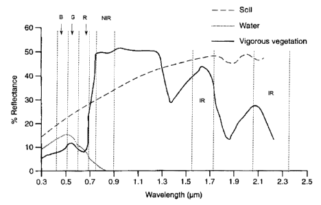
[0004] The most representative ground covers on the Earth's surface are
vegetation,
water and soil (e.g., surface not covered by vegetation or water). Their
general spectral
reflectance in different spectral ranges is characterized in Figure 1.
Vegetation curves
have a peak in the green range compared to the blue and red ranges. The
spectral
curves of soil reflectance rise proportional to the wavelength. However, the
curve of
CA 02491794 2005-O1-10
clear water usually has a peak in blue range and then descends proportional to
the
wavelength. Therefore, when the blue, green and red bands of a multispectral
sensor
are displayed with blue, green and red colour, a near natural colour composite
can be
generated with water shown in blue, vegetation shown in green and soil shown
in light
yellow grey or light red grey. But, the colour of vegetation often does not
show up as a
natural green. This makes colour composites look unnatural and not visually
pleasing.
SUMMARY OF THE INVENTION
[0005] The invention relates to a method for generating a natural colour image
comprising the steps of generating a greenness band from a multispectral image
including blue, green, red and near infrared bands and adjusting the green
band using
the greenness band.
[0006] In another embodiment, the invention relates to a method for generating
a pan-
sharpened natural colour image comprising the steps of generating a greenness
band
from pan-sharpened image bands including blue, green, red and near infrared
bands
and adjusting the pan-sharpened green band using the greenness band.
[0007] In another embodiment, the invention relates to a method for generating
a pan-
sharpened natural colour image comprising the steps of generating a greenness
band
from a panchromatic image and a pan-sharpened red band; and adjusting the pan-
sharpened green band using the greenness band.
BRIEF DESCRIPTION OF THE DRAWINGS
[0008] Figure 1 is a graph showing general spectral reflectance curves of
soil, water and
vegetation with general spectral ranges of individual multispectral bands; and
2
CA 02491794 2005-O1-10
[0009] Figure 2 is a diagram showing spectral ranges of the multispectral
bands and
panchromatic band from individual satellites.
[0010] A simple and effective method is disclosed in the present invention to
adjust the
near natural colour of a satellite colour composite to a visually more
pleasing natural
colour. This method includes two steps: (1) extracting vegetation "greenness"
from
available multispectral bands, and (2) adding (injecting) the "greenness" into
the
vegetation areas of the green band being displayed. In this way the vegetation
areas can
be made to look greener and fresher, so that the whole image appears more
natural.
This method can be used to adjust the near natural colour of original
multispectral
composites and that of pan-sharpened composites.
Adjusting the colour of original near natural colour composites
[0011] For a near natural colour composite with original multispectral bands,
the
vegetation "greenness" can be extracted using the equation:
GN = (NIRoYtg - Ro~g - ~.) j s (1)
where GN is a greenness band, NIRor~~ is an original near infrared band, Ror~g
is an
original red band, ~, is a threshold and s is a scale factor.
[0012] From Figure 1 it can be seen that the vegetation reflectance is very
high in near
infrared range and very low in red range. Consequently, vegetation covers have
very
high grey values in near infrared (NIR) band and low grey values in red (R)
band. The
3
CA 02491794 2005-O1-10
subtraction of NIR band by R band (NIRorig - Rorig) results in a subtraction
band with
high grey values in vegetation areas (because of large grey value difference
between the
NIR and R bands), low grey values in soil areas, and negative grey values in
water
areas. To make sure that the colour adjustment just happens to vegetation
areas, a
threshold ~, needs to be introduced to segment non-vegetation areas in the
subtraction
band from vegetation areas, and then the non-vegetation areas need to be
assigned with
a grey value of zero. After this segmentation and assignment, only vegetation
areas in
the subtraction band contain grey values larger than zero, while other areas
are all set to
zero, resulting in a greenness band. The threshold can be identified manually
and
automatically. Some segmentation methods can be adopted for the segmentation,
for
example, the methods introduced by Parker J.R. (1997) [Algorithms for Image
Processing and Computer Vision, John Wiley & Sons, New York, Chichester, 417
p.]. To
control the magnitude of the greenness, a scale factor s can be introduced.
[0013] Alternative methods can be used to generate the greenness band. Instead
of
using the original red band (Ror;g), the original green or blue band can be
used to
replace the red band (RoY;g) in equation (1). This replacement also can
results in a
greenness band with high grey values in vegetation areas and zero grey value
in other
areas.
[0014] After the greenness band is generated, the greenness can be added (or
injected)
into the vegetation areas of the green band to adjust the green colour of the
near natural
colour composite:
4
CA 02491794 2005-O1-10
Gndj ° Gorig ~' GN (2)
where Ga~j is an adjusted green band, Gor;g is an original green band and GN
is a
greenness band.
(0015] For the improved natural colour image display, original blue band,
adjusted
green band, and original red band are displayed with blue, green and red
colour,
respectively.
Adjusting the colour of pan-sharpened near natural colour composites
(0016] A similar method can be applied to improve the natural colour display
of pan-
sharpened colour composites. However, pan-sharpened near infrared and red
bands
need to be used to generate a high resolution greenness band:
GN~i = (NIRPS - R~s - ~,) / s (3)
where GN~~ is a high resolution greenness band, NIR~s is a pan-sharpened near
infrared
band, R~s is a pan-sharpened red band, ~, is a threshold and s is a scale
factor.
[0017] An alternative for generating a high resolution greenness band is,
instead of
using pan-sharpened near infrared band, the high resolution panchromatic band
can be
used. This alternative also results in very good results. The method for
extracting the
high resolution greenness can be described as:
CA 02491794 2005-O1-10
GNH = (Panor;g - R~s - ~.) j s (4)
where GNH is a high resolution greenness band, Panorg is an original
panchromatic
band, Rps for pan-sharpened red band, ~, is a threshold and s is a scale
factor.
[0018] From Figure 2 it can be seen that the panchromatic bands of IKONOS,
QuickBird
and Landsat 7 cover a broad spectral range including near infrared. The
average
spectral reflectance of vegetation for this broad range is not as high as in
near infrared
range, but it is still significantly higher than the average reflectance of
soil and water for
the same range (see Figure 1). Therefore, vegetation is usually brighter than
soil and
water in such panchromatic images. The subtraction of Prtnorig band by R~s
band (Panorag
- R~s) results in high grey values in vegetation areas, very low grey values
in soil areas
and water areas. A threshold ~. is also needed to segment non-vegetation areas
from
vegetation areas to set the grey values of non-vegetation areas to zero. After
this
segmentation, only vegetation areas of the subtraction band contain grey
values higher
than zero, while other areas are zero, resulting in a high resolution
greenness band
(GNH). A scale factor s can be introduced to adjust the magnitude of the
greenness.
[0019] Other variations for generating greenness bands or high-resolution
greenness
bands exist. For example, subtraction of near infrared band by green band or
blue band
and subtraction of green band by blue or red band can also generate greenness
bands.
For high resolution greenness bands, pan-sharpened bands need to be involved.
The
subtraction of original panchromatic band by pan-sharpened green or blue band
can
6
CA 02491794 2005-O1-10
also result in a high resolution greenness band. However, the greenness bands
generated with equations (1) (3) or (4) are more effective for improving the
natural
colour visualization of multispectral satellite images.
(0020] After the high resolution greenness band is generated, the greenness
can be
added (or injected) into the vegetation areas of the pan-sharpened green band
to adjust
the green colour of the pan-sharpened near natural colour composite:
GH,aa~ = GPs + GNH (5)
where GHAa~ is an adjusted high resolution green band, GPs is a pan-sharpened
green
band and GNH is a high resolution greenness band.
[0021] For the display of the improved natural colour image, pan-sharpened
blue band,
adjusted high resolution green band, and pan-sharpened red band are displayed
with
blue, green and red colour, respectively.
[0022] In a preferred embodiment of the invention, the methods of the present
invention are implemented by a programmed computer, and the method is used as
a
computer program product comprising a software tool stored on a machine-
readable
medium such as a CD Rom or floppy disc.
7