Note: Descriptions are shown in the official language in which they were submitted.
CA 02496403 2005-02-21
WO 2004/023162
PCT/US2003/025911
MULTIPLE TRANSMITTER AND RECEIVER WELL LOGGING SYSTEM
BACKGROUND OF THE INVENTION
This invention relates to the field of well logging. More specifically, the
invention relates to a novel apparatus and technique for measuring the
resistivity of
geologic formations surrounding a borehole during well logging and logging
while
drilling operations.
Formation resistivity is commonly used to evaluate geologic formations
surrounding a borehole. Formation resistivity indicates the presence of
hydrocarbons in
the geologic formations. Porous formations having high resistivity generally
indicate that
they are predominantly saturated with hydrocarbons, while porous formations
with low
resistivity indicate that such formations are predominantly saturated with
water.
"Borehole rugosity" refers to borehole irregularities created by washouts,
caves or other
borehole wall features which deviate from a smooth borehole wall surface.
Devices have been previously developed for measuring formation resistivity.
Many of these devices measure formation resistivity by measuring the
properties of
propagating electromagnetic waves. For example, Figure 1 shows an early
generation,
uncompensated propagation wave resistivity tool comprising one transmitter and
two
receivers for measuring the properties of an electromagnetic wave over two
propagation
paths. Property P11 represents an electromagnetic propagation property for the
propagation path from transmitter (Tx) to a first receiver (Rxl), and P12
represents the
same electromagnetic propagation property as used for Pll but for the
propagation path
CA 02496403 2005-02-21
WO 2004/023162
PCT/US2003/025911
from the transmitter to a second receiver (Rx2). Typically the propagation
properties
measured are attenuation and phase. A differential measurement (M) is formed
by taking
the difference between P12 and P11. This difference allows any errors related
to the
transmitter elements of the system to be removed from the final measurement
(M). The
measurement (M) is then converted to formation resistivity (R) via function
(/) which
provides the relationship between the differential propagation property (M)
and the
resistivity of the surrounding formation.
Figure 2 illustrates another propagation wave resistivity tool described in
United
States Patent No. 4,949,045 to Clark et al. (1990) and in United States Patent
No.
4,968,940 to Clark et al. (1990). This tool provided improved measurement
accuracy and
reduced sensitivity to the effects of borehole irregularities when compared to
the
"uncompensated" tool shown in Figure 1. Such tool comprised two transmitters
and a
receiver pair located between the two transmitters and is known as a borehole
compensated tool. MU represents the differential measurement for the upward
propagating electromagnetic wave from transmitter (Tx1) and MD represents the
differential measurement for the downward propagating electromagnetic wave
from
transmitter (Tx2). A borehole compensated measurement Mr3fiu can be calculated
by
averaging the upward propagating measurement, Mu, and the downward propagating
measurement, MD. The formation resistivity is determined in a fashion similar
to the
uncompensated tool by converting propagation property (Mimic) to resistivity
with
function (f). By averaging the measurements from the upward and downward
propagating electromagnetic waves, the effects of borehole rugosity on the
measured
formation resistivity can be reduced. This average also removes errors
corresponding to
2
CA 02496403 2005-02-21
WO 2004/023162
PCT/US2003/025911
the two receiver elements of the system, Rx 1 and Rx2. Like the uncompensated
device,
the borehole compensated device also eliminates the errors related to the
transmitting
elements of the system by using differential receiver measurements, Mu and MD.
Although borehole compensated tools provide a more accurate measurement of
formation resistivity than conventional uncompensated tools, such technique
requires a
tool approximately twice as long as an uncompensated tool. Tool length for an
uncompensated tool with a single radial depth of investigation is directly
related to the
spacing between the transmitter and receiver pair. Longer spacings between the
transmitter and receiver pair provide greater depth of investigation than
shorter spacings
and require a longer tool body accordingly. The tool length for a borehole
compensated
tool as described in patents '045 and '940 with an equivalent radial depth of
investigation
as an uncompensated tool will be approximately twice as long because of the
requirement
of both upper and lower transmitter elements.
Another compensated tool was described in United States Patent No. 5,594,343
to
Clark et al. (1997) wherein the transmitters were asymmetrically located on
both sides of
a receiver pair. Similar to the '045 and '940 Patents previously described,
such tool also
required placement of at least one transmitter on each side of the receiver
pair and also
required a long tool body.
The compensated tools described above require a long tool body in the borehole
to correctly position the transmitters and receivers. Long well tools not only
require
additional material and greater manufacturing cost but are more likely to bind
or stick in
narrow or deviated boreholes. This problem is particularly acute in
multilateral wellbores
having a reduced entry radius and in highly deviated wellbores. Accordingly, a
need
3
CA 02496403 2005-02-21
WO 2004/023162
PCT/US2003/025911
exists for an improved system capable of facilitating tool movement within a
wellbore
while gathering useful information regarding geologic formation
characteristics such as
resistivity and other geologic formation indicators.
SUMMARY OF THE INVENTION
The invention provides a system for evaluating a geologic formation property
proximate to a borehole through such formation. The system comprises a tool
body
moveable through the borehole, a first transmitter engaged with the tool body
for
generating a signal into the geologic formation, a second transmitter engaged
with the
tool body proximate to the first transmitter for generating a signal into the
geologic
formation, a first receiver engaged with the tool body for receiving signals
generated by
the first and second transmitters, and a second receiver engaged with the tool
body
proximate to the first receiver for receiving signals generated by the first
and second
transmitters.
Another embodiment of the invention provides an apparatus comprising a tool
body moveable through the borehole, a first transmitter engaged with the tool
body for
generating an electromagnetic wave into the geologic formation, a second
transmitter
engaged with the tool body proximate to the first transmitter for generating
an
electromagnetic wave into the geologic formation, a first receiver engaged
with the tool
body for receiving electromagnetic wave energy generated by the first and
second
transmitters and for generating electrical signals representing the
electromagnetic wave
energy, a second receiver engaged with the tool body proximate to the first
receiver for
receiving electromagnetic wave energy generated by the first and second
transmitters and
4
CA 02496403 2005-02-21
WO 2004/023162
PCT/US2003/025911
for generating electrical signals representing the electromagnetic wave
energy, and a
controller for processing the electrical signals generated by the first .and
second receivers.
The method of the invention comprises the steps of deploying a tool body in
the
borehole, of generating electromagnetic wave energy from the first transmitter
at a
selected location in the borehole, of generating electromagnetic wave energy
from the
second transmitter at a selected location in the borehole, of operating the
first and second
receivers in response to the electromagnetic waver energy generated by the
first and
second transmitters to generate electrical signals representing the
electromagnetic
waveenergy, and of transmitting said electrical signals to the controller.
BRIEF DESCRIPTION OF THE DRAWINGS
Figure 1 illustrates a conventional uncompensated propagation wave resistivity
tool.
Figure 2 illustrates a form of a conventional compensated propagation wave
resistivity tool.
Figure 3 illustrates a schematic view of a propagation wave resistivity
system.
Figure 4 illustrates a schematic view of two depth positions leading to
compensated measurements.
Figure 4a illustrates the reduction of borehole rugosity effects with a
compensated
tool.
Figure 4b illustrates the asymmetrical vertical response of an uncompensated
tool.
Figure 4c illustrates the symm= etrical vertical response of a compensated
tool.
Figure 5 illustrates a depth-aligned compensated tool.
CA 02496403 2005-02-21
WO 2004/023162
PCT/US2003/025911
Figures 6 through 9 illustrate different transmitter and receiver
configurations for
a depth-aligned compensated propagation wave resistivity tool.
Figure 10 illustrates a block diagram for a depth-aligned compensated tool.
Figure 11 illustrates the depth alignment process for electronic error
compensation.
DESCRIPTION OF THE PREFERRED EMBODIMENTS
The invention provides a unique propagation wave resistivity system. The
system
is capable of providing two depths of investigation as shown in Figure 3. Tool
10
comprises tool body 12 carrying two transmitters identified as transmitter
pair 14 and two
receivers identified as receiver pair 16. First transmitter Txl is located
proximate to
second transmitter Tx2. Located at a selected distance from transmitter pair
14 are first
receiver Rxl and second receiver Rx2.
Property Pll illustrates the electromagnetic property of the propagation path
from
first transmitter Txl to first receiver Rxl. Property P12 illustrates the
electromagnetic
property of the propagation path from first transmitter Txl to second receiver
Rx2.
Similar properties are illustrated for second transmitter Tx2, wherein
property P21
illustrates the propagation path from second transmitter Tx2 to first receiver
Rxl, and
P22 illustrates the propagation path from second transmitter Da to second
receiver Rx2.
Tool 10 provides two differential measurements (Ms and Mai) from receiver
pair 16. MRS is derived from receiver pair 16 using short-spaced transmitter
Da and MRL,
is derived from receiver pair 16 using long-spaced transmitter Txl. Both of
these
measurements can be converter to resistivity with functionsf and g.
6
CA 02496403 2005-02-21
WO 2004/023162
PCT/US2003/025911
In addition to the two dual-receiver measurements (MRS and MRL), two
additional
differential measurements (Mrs and MTh) can be made from transmitter pair 14.
MTS is
derived from transmitter pair 14 using short-spaced receiver Tx2, and MTL is
derived
from transmitter pair 14 using long spaced transmitter Txl. If the spacing
between
transmitter pair 14 is equal to the spacing of receiver pair 16, the functions
to convert the
dual-transmitter measurements, MTS and MTL, into resistivity can be the same
functions
(f and g) for the dual-receiver measurements from receiver pair 16.
One advantage of this inventive embodiment over a standard borehole
compensated device shown in Figure 2 is that the invention provides two
different
spacings and two different depths of investigation. Borehole rugosity effects
are reduced
in this new embodiment by using both the receiver pair 16 measurements and the
transmitter pair 14 measurements. This new method of compensation is
accomplished by
depth shifting to align in depth the data from transmitter pair 14 with the
data from
receiver pair 16 as illustrated by Figure 4.
As shown in Figure 4, an average of receiver pair 16 measurements can be made
with transmitter pair 14 measurements to obtain two compensated resistivity
measurements. This compensated measurement will have reduced borehole rugosity
effects similar to conventional borehole compensated devices. In this manner
the
invention accomplishes borehole compensation in an apparatus having a tool
body
significantly shorter than a standard borehole compensated device. In
addition, two
measurements with different depths of investigation are provided instead of
the single
depth of investigation provided with a conventional borehole compensated
device. As
7
CA 02496403 2005-02-21
WO 2004/023162
PCT/US2003/025911
used herein, the term "depth-aligned compensation" is used to describe a
compensation
method using depth aligned receiver pair 16 and transmitter pair 14 data.
Figure 4 illustrates how the measurements from receiver pair 16 and
transmitter pair 14
can be averaged to produce a compensated resistivity. This process can be
accomplished
by averaging the dual-transmitter propagation measurements with the dual-
receiver
propagation measurements and then transforming the average measurements into
resistivity, or alternatively, by averaging the resistivities computed from
the dual-
transmitter measurements with the resistivities computed from the dual-
receiver
measurements. The resulting reduction in borehole rugosity effects is shown in
Figure
4a. In addition to borehole rugosity effects, the compensated apparatus
illustrated in
Figure 4 also removes vertical response asymmetries typically associated with
an
uncompensated device. This asymmetry shows up at formation bed boundaries
wherein
the log of measured resistivity as a function of depth from an uncompensated
tool will
have a different character as the tool enters a conductive bed, when compared
to a log as
the tool exits a conductive bed (Figure 4b).
This asymmetrical vertical response effect can be explained by examining the
uncompensated measurements from receiver pair 16. As receiver pair 16 of the
device
enters a resistive bed boundary from the top the respective transmitter has
already
penetrated the bed. At this position a larger portion of the propagating
electromagnetic
wave is contained in the resistive bed. The opposite happens at the bottom bed
boundary
as the respective transmitter is no longer embedded in the resistive bed as
receiver pair 16
transverses the lower bed boundary. In this manner a smaller portion of the
propagating
electromagnetic wave is contained the resistive bed at this position, and this
geometrical
8
CA 02496403 2005-02-21
WO 2004/023162
PCT/US2003/025911
effect causes the resistivity log to have a different shape at the top and
bottom of
formation bed boundaries. By using both receiver pair 16 and transmitter pair
14
measurements, the effects of this vertical response asymmetry are averaged to
provide a
measurement responding to bed boundaries in a consistent symmetrical fashion
regardless of the tool geometry as the tool traverses the bed boundary (Figure
4c).
Receiver and transmitter errors (removed with a standard borehole compensated
tool) are still present. The dual-receiver measurements from receiver pair 16
contain
receiver errors and the dual-transmitter measurements from transmitter pair 14
contains
transmitter errors, however such errors can be compensated with electronic
features
incorporated in the design of the apparatus as described later in this
disclosure.
One embodiment of a depth-aligned compensated propagation wave resistivity
tool 20 is shown in Figure 5. Four parameters can describe the location and
layout of the
tool 20 antennas. These four parameters are the total number of transmitters
(J), the total
number of receivers (K), the spacing between upper transmitter TxJ and the
lower
receiver Rxl (Znan), and the spacing between adjacent transmitter and receiver
antennas.
Four different tool layout examples are illustrated in Figures 6 through 9,
wherein
different combinations of receivers and transmitters are illustrated.
As described above the transmitters are located below the receivers. However,
configurations placing the receivers below the transmitters can be used and
will have the
same response as a device positioning the transmitters below the receivers.
Placement of
the transmitters and receivers above or below the other depends on the desired
implementation.
9
CA 02496403 2005-02-21
WO 2004/023162
PCT/US2003/025911
The method of depth-aligned compensation previously described can be extended
to other possible tool layouts by properly aligning in depth the dual-receiver
and dual-
transmitter data of equal spacing. The total number of different depths of
investigation
provided by this method is equal to the total number of unique transmitter to
receiver-pair
spacings (NTRR). A block diagram of a 3-transmitter, 3-receiver version of a
depth-
aligned compensated propagation wave resistivity tool 30 is illustrated in
Figure 10. Tool
30 contains a single transmitter circuit 32 that drives one of three different
transmitter
antenna Txl, Tx2, and Tx3 via an electronic switch 34. The transmitters are
typically
selected in sequence under the control of an acquisition routine programmed in
acquisition controller and processor 36. Three sets of similar receiver
electronics 38
acquire the data from the three receiver antennas Rxl, Rx2 and Rx3
simultaneously. A
local oscillator provides the frequency references for both the transmitter
and receiver
mixer circuits 40. After the mixer 40, the receiver signals are passed through
low pass
filters 42 and then on to a multi-channel analog-to-digital converter 44.
Acquisition controller and processor block 36 directs the sequencing and
timing
of the acquisition electronics and also acquires and processes the measurement
data. An
interface to accept commands from and pass data to the user is also provided
by block 36.
Such an interface can connect to a telemetry system (not shown) to provide a
means to
acquire and transmit data in real time such as in the determination of
formation resistivity
while drilling.
Although depth-aligned compensation reduces the effect of borehole rugosity
and
provides a symmetrical vertical response, the electronic errors associated
with the
transmitters and receivers preferably use an additional compensation method.
This
CA 02496403 2005-02-21
WO 2004/023162
PCT/US2003/025911
electronic compensation method involves measuring the transmitter errors
directly with
an electronic circuit and calculating the receiver errors by depth aligning
and comparing
equivalent propagation measurements from different transmitter-receiver pairs.
This
process is illustrated in Figure 11 for a three-transmitter and three-receiver
tool. In this
example the electronic calibration only needs four quantities ¨ the
differential
propagation measurement error of the two close spaced receiver pairs and the
differential
propagation measurement error of the two close spaced transmitter pairs.
Typically these
differential propagation measurements are attenuation and phase difference,
but this
calibration process can also be applied to other measurements. Referring to
Figure 11,
the transmitter propagation measurements for Txl and Tx2 using receiver Rxl at
depth
position A can be written as
=End 4" PllA + ERx1 ,
A21 ETx2 P21A ERxl,
where EMI and ET,c2 are the errors associated with transmitters Txl and Tx2
respectively
and E1 is the error associated with receiver Rxl. The dual transmitter
propagation
measurement for Txl and Tx2 using Rxl can be written as
MTM = A21 ¨ All = (ETx2 P21A ERx1) (ETx1 PllA + ERxi)
or
MTM (P21A P11A) + (Brx2 ¨ Erxi) = (1)
The quantity (P21A ¨ P1 IA) is the differential propagation property to be
measured
without error. Error associated with receiver Rxl cancels and the error
remaining,
(En2 ¨ Eni), is due to transmitters Txl and Tx2. In this example, M=rm is the
medium-
spaced differential propagation measurement. Similar derivations of the short-
spaced,
11
CA 02496403 2005-02-21
WO 2004/023162
PCT/US2003/025911
Mrs and long-spaced, MTL, dual-transmitter propagation measurements can be
made.
MTS and MTL can be written as
MTS = A31 ¨ A21 = (P31A - P21A) (ETx3 Enc2) (2)
and
MTL = A23 ¨ Al3 = (P23A ¨ P13 + (ETx2 ¨ Brxi) (3)
As shown in equations 1, 2 and 3, the errors in MTS, MTm and MTL are all
differential
transmitter errors.
These differential transmitter errors are directly measured in the tool by
sampling
the transmitter current 46 and the transmitter voltage 48 and by deriving
correction
factors for data acquired with each transmitter pair 14. Outputs from
transmitter sense
circuit 50 are treated in a similar fashion to the receiver signals and passed
to analog-to-
digital converter 44. The differential transmitter errors are then calculated
by forming the
difference of certain characteristics of the sampled transmitter signals. For
instance, the
differential transmitter phase errors can be calculated from the phase
difference of the
sampled signals and the differential transmitter attenuation errors can be
calculated from
the difference of the amplitudes of the sampled transmitter signals. Since
these
transmitter sense outputs are processed with the same circuits, any systematic
errors
associated with the acquisition circuits are removed when these differential
corrections
are calculated. After the differential transmitters errors have be calculated
from the
sampled transmitter signals such errors can be subtracted from MTS, MTM and
MTL to
remove errors associated with the transmitter elements of the system.
12
CA 02496403 2005-02-21
WO 2004/023162
PCT/US2003/025911
In a similar manner, expressions for the dual-receiver propagation
measurements
can be derived. Referring to Figure 11, the receiver propagation measurements
for Rxl
and Rx2 using receiver Tx2 at depth position A can be written as
A22 = ETx2 1P22A. + ERx2,
A21 = ETK2 + P2 lA ERx1 ,
The dual-receiver propagation measurement, MRm, can then be written as
MRM = A21 ¨ A22 = (Erx2 + P21A + ERxi) (Erx2 + P22A + ERx2)
or
Mizm = (P21A ¨ P22A) + (Elba - ERx2) = (4)
Similar derivations of the short-spaced, MRS and long-spaced, MRL, dual-
receiver
propagation measurements can be made. MRS and MRL, can be written as
MRS = (P31A ¨ P32A) + (ERxi ERx2) = (5)
and
MRL = (P12A ¨ Pl3A) + - ER,$) . (6)
As shown in equations 4, 5 and 6, the errors in MRs, MRm and MRL are all
differential
receiver errors.
The differential receiver errors can be determined with the use of the
transmitter
error measurements described above and with a process that involves depth
aligning and
comparing equivalent propagation measurements from different transmitter-
receiver
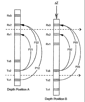
pairs. Referring again to Figure 11, the tool body has been moved by amount AZ
from
depth position A to depth position B. As illustrated in Figure 11, a number of
propagation paths at position A are equivalent to other propagation paths at
position B.
For instance, P1 'A is equivalent to P22B, P12A is equivalent to P23B, etc. If
no
= 13
CA 02496403 2005-02-21
WO 2004/023162
PCT/US2003/025911
transmitter or receiver errors are present in the system, the measurement All
for
propagation path P1 IA will be equal to the measurement B11 for propagation
path 1322B.
From the above references to transmitter errors, the measurement All can be
written as
All =ETA + MA + ERxl,
Similarly, the expression for B22 can be written as
B22 = ETx2 + P22B + ER4 ,
Forming the difference of All and B22 results in
All ¨ B22 = (End + PllA + ERxi) ¨ (Erx2 + P22B + ERx2)
which simplifies to
Al 1¨ B22 = (ERA. ¨ ER,a) + (Emi ¨ Ena) + (P1 1 A ¨ P22B) =
The term (P11A ¨ P22B) is equal to zero since the propagation paths are
identical. This
permits the differential receiver error to be expressed as
(ERxi ¨ ERx2) = (All ¨ B22) + (Erx2 ¨ Erxi)
Similarly, the remaining differential receiver error can be expressed as
(ERx2 ¨ ER,a) = (A22 ¨ B33) + (ETx3 ¨ Erx2) =
The invention permits determination of all four of the required differential
measurement errors, including the two differential-transmitter measurement
errors and
the two differential-receiver measurement errors. With the differential errors
defined, the
differential-transmitter errors can be subtracted from the appropriate dual-
transmitter
measurements, MTS, MTM and MTL and the differential-receiver errors from the
appropriate dual-receiver measurements, MRs, MRm and MRL, thereby providing
14
CA 02496403 2005-02-21
WO 2004/023162
PCT/US2003/025911
propagation measurements free of the errors associated with the transmitter
and receiver
elements of the system.
Other differential errors can be identified, such as the differential receiver
error
(Elba ¨ ER,a) derived from the measurements All and B22. An alternate
relationship
using A21 and B32 can be used to obtain another expression for (ERxi ¨ Ea) as
follows:
(B1x1¨ ERx2) = (A21 ¨ B32) + (En3 ¨ Enc2) =
Similar alternate versions of (ER,,2¨ ER,c3) can also be derived, thereby
reducing noise in
the differential errors by averaging all of the possible determinations of
each differential
error. In addition, noise in the differential errors can be further reduced by
averaging the
determined values over depth since they will not vary directly as a function
of depth.
This occurs because the primary mechanism for causing drifts in the
differential errors is
time, temperature or pressure and not depth.
The controller (which can include downhole or surface located components) is
capable of producing a compensated resistivity measurement of the geologic
formation
by averaging uncompensated dual-receiver resistivity measurements with
uncompensated
dual-transmitter resistivity measurements of the geologic formation taken from
two
selected locations within the borehole. This averaging provides a compensated
resistivity
measurement with symmetrical vertical response and reduced effects from
borehole
rugosity. The controller can also be capable of producing a compensated
resistivity
measurement of the geologic formation by averaging dual-receiver propagation
measurements (such as attenuation and phase difference) with dual-transmitter
propagation measurements of the geologic formation taken from two selected
locations
CA 02496403 2012-08-16
230555-3
within the borehole. This averaging results in a compensated resistivity
measurement
with a symmetrical vertical response and reduced effects from borehole
rugosity.
In the example shown in Figure 11, compensation of errors from the
transmitting and receiving elements of the system can be made by measuring
currents
and voltages used by first, second and third transmitters, by measuring
currents and
voltages of the electrical signals generated by the first, second and third
receivers, and
by operating the controller to derive corrections for the transmitter
propagation errors
from the differences between such current and voltage measurements. In
addition, the
controller can be operated to derive receiver propagation errors from the
corrections
for the transmitter propagation errors and from depth aligned receiver
propagation
measurements.
The invention has significant advantages over prior art tools. Such advantages
include a shorter tool length, multiple depths of investigation with fewer
antennas,
compensation for the asymmetrical vertical response of electromagnetic wave
tools,
compensation for borehole rugosity effects, and compensation for the errors
caused by
the transmitter and receiver elements of the apparatus.
Although the invention has been described in terms of certain preferred
embodiments, it will become apparent to those of ordinary skill in the art
that
modifications and improvement can be made to the inventive concepts herein
without
departing from the scope of the invention. The embodiments shown herein are
merely
illustrative of the inventive concepts and should not be interpreted as
limiting the
scope of the invention.
16