Note: Descriptions are shown in the official language in which they were submitted.
1l
CA 02502871 2005-03-31
-1-
STRUCTURAL-GEODYNAMIC METHOD OF
FORECASTING OF LOCALIZING HIGHLY
PERMEABLE POROUS-FRACTURED
COLLECTING BASINS DEVELOPMENT ZONES
AND HYDROCARBONS DEPOSITS
Field of the Invention
[0001] The present invention relates generally to a method of
prospecting for hydrocarbons. In particular it relates to a structural-
geodynamic
method of forecasting of localizing highly permeable porous-fractured
collecting
basins development zones and hydrocarbons deposits.
Background of the Invention
[0002] Spatial localization of accumulations of oil and gas is an important
scientific and commercial task tackled by geological science. As a result of
this
work, various methods and techniques have been created. These methods
have the same purpose i.e. the forecasting of oil and gas resources based on
such criteria as efficiency and, localizing of zones of highly permeable
collecting
basins. However, they use absolutely different methods and techniques.
[0003] There exists a well-known classical method of prospecting for oil
and gas based on exploration of seismic profiles with the purpose of finding
"traps", i.e. natural reservoirs filled with oil and gas, with subsequent
drilling of
deep expensive wildcat wells, but only three of every ten "traps" contain
commercial hydrocarbon deposits. The shortcoming of this method is the low
rate of success in prospecting and high costs.
[0004] There exists another well-known method of prospecting for
hydrocarbons based on seismic prospecting. This method suffers from
relatively high costs i.e. the cost is 10 times higher than the method
disclosed
below. Further this method offers relatively low correlation with discovery of
oil
and gas. Some of the explanation lies with the fact that in physical terms the
CA 02502871 2005-03-31
-2-
method is based on the phenomenon of formation of the trace of the diffusive
flow above the accumulations of oil and gas. In such an approach errors can
occur if the diffusive flow remains while oil or gas are absent. The method
detects the fact of vertical migration of hydrocarbons rather than the
deposits
themselves.
[0005] There also exists another method titled "Method of detecting
accumulations of hydrocarbons including oil fields, natural gas pools and gas
condensate reservoirs and other deposits located at various depths, as well as
contamination of the earth surface with hydrocarbons and other chemical
substances based on remote sounding of the earth surface and bottom layer of
the atmosphere differing from other methods in that it uses an ultraviolet
wavelength band for remote sounding" (Registration number of application:
98109321/28 dated September 27, 2000, RU). This method, however, does not
provide for the obtaining direct information on manifestations of solids
dispersion processes and development of geodynamic processes. The zones
of dispersion are identified based on formal procedure of identification of
crossing of lineaments, and as practice has shown in 75 % of cases this
procedure leads to errors. Further, the information received with the use of
this
method does not contain data on the location of the structure affected by
dispersion in volumetric terms, and therefore it does not allow making
conclusions on manifestations of processes of dispersion as a function of
sections of deposits being explored. The method provides a low rate of
successful confirmation of the results of the forecasts for zones of
dispersion,
especially in case of determination of the location of planned wells (not more
than .20-25 %) due to the shortcomings in the scientific substantiation of the
model of formation of structures affected by thinning dispersion at the modem
stage. The method suffers from a lack of the information on geoindicating
factors of landscapes reflecting the features of the formation and
manifestations of geofluid-dynamic processes, which are regarded as of first
importance in the process of exploration of zones affected by dispersion
processes. Finally, the method suffers from relatively high cost. A structural-
geodynamic method of forecasting of localizing highly permeable porous-
CA 02502871 2005-03-31
-3-
fractured collecting basins development zones and hydrocarbons deposits is
based on the genetic correlation between certain features of landscapes with
the existence of highly permeable porous-fractured collecting basins
development zones and of hydrocarbons deposits, formed as a result of
tectonic thinning dispersion of solids.
[0006] This method differs from other known methods in that it uses
specific processing ("deciphering") of information contained in photographs
taken in the visible, infrared and heat wavelength bands and earth surface
photometry as well as results of mathematical analysis of height profiles of
landscapes, data on the structure of block fields of the objects being
explored
and optical characteristics of the landscape and allows to detect
spectrometric
and structural-geochemical anomalies. Then the processed data is compared
with reference data and this allows making a conclusion on the productivity of
oil and natural gas fields and the extent to which the explored object is
developed in the context of the zones of highly permeable porous-fractured
collecting basins.
Summary of the Invention
[0007] In an aspect of the invention, there is provided a method for
prospecting for oil and gas deposits, said method comprising: outlining of
highly
permeable collecting basins development zones, performing an aerospace
survey of a landscape, determining a spectral reflectivity over the landscape,
incorporating the height profile, block fields, aerospace survey and spectral
relativity in order to produce a predictive analysis of linear zones and
recent
vertical displacements of the landscape.
[0008] In another aspect of the invention, there is provided a method for
prospecting for oil and gas deposits, said method comprising: outlining of
highly
permeable collecting basins development zones, performing an aerospace
survey of a landscape, performing a land radar survey of the landscape
performing a field photographic survey of the landscape determining a spectral
reflectivity over the landscape, incorporating the height profile, block
fields,
CA 02502871 2005-03-31
-4-
aerospace survey and spectral relativity in order to produce a predictive
analysis of linear zones and recent vertical displacements of the landscape.
[0009] The proposed methods allow outlining the locations of deposits of
gas and oil and zones of highly permeable porous-fractured collecting basins
at
the stage of prospecting for oil and gas.
Brief Description of the Drawings
[0010] Preferred embodiments of the present invention will now be
described, by way of example only, with reference to the attached Figures,
wherein:
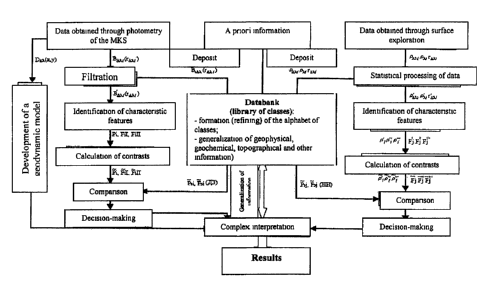
Figure 1 shows a block diagram of the process of processing of
the results of remote and surface photometry with the purpose of detecting
optical anomalies,
Figure 2 shows a 3 line filter example of the behaviour of the
value of the factor FI for oak leaves selected along one of the reference
routes
at a deposit of hydrocarbons, and
Figure 3 shaows a map plotting the locations of optical anomalies
associated with oil and gas accumulations.
Detailed Description of the Invention
[0011] This method is based on the theory of geo fluid dynamic
structures (GFDS) of the lithosphere. This theory infers linear zones of the
curve of the tension-deformation condition of the lithosphere which are, as a
rule, of vertical, and less often, of subvertical character. The method is
also
based on detection of anomalies in multispectral and height profiles of
landscapes, associated with recent vertical displacement of the earth surface
over accumulations of hydrocarbons, as well as the features of the reflective
characteristics of the elements of the landscapes located over oil and gas
deposits.
[0012] According to one embodiment, the instant method can be divided
into a set of consecutive operations:
CA 02502871 2005-03-31
-5-
[0013] Step 1: Exploration of the height profile and block fields of
landscapes including:
[0014] 1.1. Outlining of highly permeable collecting basins development
zones includes the following steps:
[0015] 1.1.1. Structural-geomorphologic surveying,
[0016] 1.1.2. Producing topographic maps including man-made features
- roads, villages, industrial facilities and sites, etc.,
[0017] 1.1.3. Detection of landscape features and objects connected
with the geofluid dynamic structures (GFDS) (average dispersion),
[0018] 1.1.4. Producing maps showing distribution of average
dispersion,
[0019] 1.1.5. Producing maps showing lineaments,
[0020] 1.2. Aerospace geological (geodynamic) surveying including:
[0021] 1.2.1. Selection of objects on which information is to be obtained
with the use of aerospace multizone and radiolocation surveying according to
the following criteria: season when the surveying is carried out; multizone
survey ranges (VNIR, SWIR, TIR bands); cloudiness; time of the day,
[0022] 1.2.2. Preliminary processing of the information obtained during
surveying: geometrical correction; spectral correction; contrasting; and
quantization;
[0023] 1.2.3. Deciphering the lineament net and producing a map
showing lineaments,
[0024] 1.2.4. Deciphering the geodynamic nodes and producing a map,
[0025] 1.2.5. Estimating the geofluidodynamic features of the
geodynamic nodes (identification of geofluidodynamic structures) and their
component elements - average dispersion; Analysis of geofluidodynamic and
aerospace geological survey; Production of maps showing the location of highly
permeable porous-fractured collecting basins development zones. The zones
characterized by dispersion are identified based on the landscape features
reflecting the processes of soils' thinning and dispersion and migration of
CA 02502871 2005-03-31
-6-
formation fluids. This allows identification of zones characterized by
dispersion
with probability of up to 85 %.
[0026] Step 2: Exploration of the landscape in the optical field. In the
process of remote or earth surface survey of territories and objects one
identifies linear optical anomalies in reflective characteristics of plants
growing
over oil deposits and natural gas pools. Detection of the areas of optical
anomalies on the explored territory is carried out based on the analysis of
linear
anomalies, detected on surface routes and remote profiles.
[0027] 2.1. Remote exploration. Such methods are used in case of
utilization of materials obtained in the course of space-and-aerial surveying
in
multiple zones with the use of narrow spectral bands, which range from 0.45 to
0.9 microns and from 8.5 to 12.5 microns with spatial resolution not less than
30 m. Technology of processing of the materials obtained in the course of a
multizone survey includes: production of a synthesized image based on the
available materials; identification of plots of land with homogeneous
vegetation;
topographic representation of the structures underlying oil and/or natural gas
fields on a map; choice of a rational net of profiles and points at which
photometry measurements are to be made; determination of quantitative
characteristics of the entire array of video images zone;and preliminary
statistical processing of obtained parameters.
[0028] 2.2: Earth surface measurements. Earth surface measurements
are carried out in order to compare the obtained results with those of remote
measurements made. Reference plots of land are used. These have been
investigated via drilling and are in the same geological and landscape
conditions as the explored objects. The technology of processing of the
materials obtained in the course of an earth surface survey includes
photometry
of varies kinds of homogeneous plants growing within the limits of the
explored
objects and at the background areas. Depending on the kind of species of
plants (trees, shrubs, bushes, grass, etc.) one uses different type
photometers.
The measurements are carried out in the same spectral bands as in the case of
remote exploration. The widths of the spectral bands need not exceed 15-20
nm. The time during which the photometry measurements are made need not
CA 02502871 2005-03-31
-7-
exceed 1.5 hour. In case of earth surface reconnaissance the routes for
photometry measurements are to be chosen within the obtained remote profile.
Statistical processing of the results of earth surface photometry is carried
out
with the use of standard methods.
(0029] Step 3: Processing. Mathematical processing of the results of
earth surface and remote exploration, detection of linear and area optical and
thermal anomalies is accomplished with the use of factor analysis and other
standard software products. This is based on the complex use of the results of
the registration of optical reflective characteristics of plants by distant
and earth
surface methods. This technology includes statistical processing of photometry
results, identification of informative signs, plotting related analytical
curves and
systems of isolines, complex analysis with the use of a priori information,
calculation of the spectral contrasts for anomalies and their topographic co-
ordinates, evaluation of the intensity and interpretation.
[0030] 3.1. Statistical processing and averaging measurements
results. This step is used for discarding those magnitudes of the parameters,
whose standard deviation exceeds the tripled standard deviation calculated for
~ 2 the entire sample of the collected plants of a certain
~Cr,-r~) species for the given route:
s=
n-1
(1)
where s is the standard deviation for the sample for the measured value of the
reflection value in the point for the zone of the spectrum r average value of
the
sample reflection value and n is the number of measurements made with the
sample. Each sample is a set of measured data for a particular route and kind
of vegetation. As a result of statistical processing of the obtained data for
each
area explored one obtains arrays of primary data of dimension (NxM), where N
is the number of points on the route where samples have been collected, M is
the number of the zones of the spectrum used. Each element of such an array r
(i, j) is characterised by the reflection value for vegetation in the i~th
point of the
CA 02502871 2005-03-31
- 8 -
route for the j-th zone of the spectrum. The schemes of processing of remote
and earth surface photometry are identical. The difference consists only in
the
nature of the information processed: in case of photometry of materials
obtained in the course of aerospace surveying of multiple zones this
information consists of the values of relative brightness of the video images
BAX, which are functions of the coefficients of zone brightness (CZB) at each
point in zones of the spectrum, where photometry has been carried out, and in
case of earth surface photometry such information consists of the values of
CZB in three to eight zones of the spectrum. The information obtained in each
of the branches is divided into two flows: information from reference deposits
is
intended for clarification and formation of the alphabet of classes, and
information from explored sites is used for the formation of typical
multidimensional spectral characteristics (vectors) of the condition of the
vegetation in each point where photometry has been carried out. The
dimension of this vector corresponds to the number of channels (zones), in
which records have been made. In most cases the information on the objects
explored is incorporated in a number of different characteristics rather than
a
single characteristic. In practice in case of remote sounding of vegetation
one
widely uses various combinations of characteristics of brightness, which are
one-dimensional complex spectral deciphered characteristics (vegetation
indices).
[0031 j 3.2: The Use of factor analysis model. The parameters r(i, j)
characterising the spectral reflective characteristics of the vegetation are
normally distributed random variables with finite dispersion, which correlate
with
each other. This is a consequence of their linear dependence on a certain
number of other parameters, reflecting the characteristics of the environment,
including oil and gas accumulations. The essence of the factor analysis is the
search for these unknown linearly independent (orthogonal) parameters, called
factors. In this case matrix R is the matrix of output data used for the
factor
analysis. Identification of factors is carried out with the use of "main
components" method. The number of the selected factors is determined
through setting the minimal numbers of elements of the correlation matrix,
CA 02502871 2005-03-31
_g_
which are used for evaluation of the degree of correlation between the factors
with all output parameters. Figure 2 shows a 3 line filter example of the
behaviour of the value of the factor FI for oak leaves selected along one of
the
reference routes at a deposit of hydrocarbons. The calculations have been
made for 8 zones of the spectrum, which correspond to the reflective
characteristics of oaks on wavelengths of 450, 500, 550, 600, 700, 720 and 750
nanometers. The measurements have been carried out with the use of
spectrophotometer SF- 18 of spectral resolution of 1 nanometer, the
measurement accuracy being 1 %. The analysis of the matrix characterising the
influence ("load") of the selected factors shows that the variable factor FI
is
influenced by the high "load" produced by the first seven variables. A part of
the
entire dispersion attributed to the FI factor is 0.74.
[0032] 3.3: Evaluation. The intensity of anomalies and clarification of
their borders have been made based on the analysis of the values of contrasts
between the object and the background. The values of contrasts of spectral
reflection value in each point of a route have been calculated with the use of
an
applied program and the current value of the reflective characteristic of the
vegetation along the route for j-th spectral channel. The program outputs the
values of contrasts in the form of an array of data.
[0033] Step 4: Formation of data based on the results of earth surface
and remote exploration. The main technical result of the use of this method is
the creation of maps (see figure 3) plotting the locations of optical
anomalies
associated with oil and gas accumulations (projects of oil and gas production
with good prospects for the future), such maps being the main criteria for
drilling
wildcats.
(0034] According to another embodiment of the present invention, the
developed method includes:
[0035] Complex aerospace research for invisible, infrared, thermal
spectrums and radar-tracking range on land and in near-shore zones (at a
shelf) with the application techniques of remote systems diagnostics and earth
remote sensing; and
CA 02502871 2005-03-31
-10-
[0036] Field works for determining the influence of the anomalous
factors above oil and gas deposits on vegetation in a visible spectrum.
[0037] Complex aerospace research including the following stages:
Preparation works (encapsulation of space, geo-geophysical and topographical
information); Thematic decoding of materials of aerospace shootings (study of
optical characteristics of landscapes, account of contrasts and vegetative
indexes), selection of optical anomalies; Structural - geomorphological
research, the fulfillment of field works, generation of landscape and geo-
geophysical models, the integrated analysis of models and outputs of
structural - geomorphologic, field and remote research; Selection of
perspective objects, sites for drilling of prolific wells, block fields,
construction of
resulting maps on paper and magnetic carriers, drawing up of a report for a
customer on executed research.
[0038] Preparation works involving the preparation of the researched
territory and general geological data, for a comparison with materials
received
after space shooting is decoded. The task is the survey study of researched
territory general characteristics: Landscape (geomorphologic, botanical,
hydrological, soil, and other); and Structural (tectonic) - Oil and gas
(geological)
- Geophysical - Biochemical Gas (chemical) - Neo (tectonic) - Geodynamic.
[0039] After preparation works there is thematic decoding of materials of
aerospace shootings. This involves regional and local research of perspective
sites. Tasks of this stage include determination of researched square prospect
and decision making about expediency of local research; and fulfillment of
selected sites local research to determine coordinates for drilling of
prolific
wells. The substeps of the stage are: Complex aerospace research; a study of
a landscape optical field and revealing of thermal anomalies in separate zones
of spectrum; and comprehensive analysis of researches outcomes(
comprehensive analysis and geological interpretation of isomeric type
anomalies (area anomalies) and a linear type (linear anomalies). The decoding
is made processing aerospace surveyed materials in narrow spectral bands:
0.45 to 0.9 microns (visible & near infrared); 8.5 to 12.5 microns (thermal);
and
0.8 - 23.0 cm (radar). The used multi-zone surveyed materials should
CA 02502871 2005-03-31
-11-
correspond to the certain space and spectral resolution specifications. The
influence of the anomalous factors to vegetation results in their multi-
spectral
characteristics and to physiological modifications.
[0040] The third stage is the completion of structural - geomorphological
research & field works. The purpose of stage three is a determination of
cumulative effect on optical characteristics of vegetation using ground
colorimetry. Tasks of this stage include analysis of soil and vegetative space
placing; analysis of hydrological researches data; colorimetry of vegetation
sample in researched regions; Preprocessing of obtained materials (analysis of
anomalies space placing and analysis of probability of anomalies fluid-dynamic
conditionality); and component analysis of multizone shooting materials.
[0041] The fourth stage is the preparation of the report on the executed
Research. The purpose of stage four is the comprehensive analysis of local
research and determination of site coordinates for drilling of prolific wells.
Tasks
in this stage include: Mapping of oil-and-gas prospects; ranking of
geophysical
structures (objects, prepared by a geophysical method) on a efficiency
criterion;
mapping of zones of rocks softening (sites for drilling of prolific wells )
and
scheming of studied sites break- block structure. The result is a Map of
highly
permeable porous-fractured collecting basins development zones for
determination sites for drilling of prolific wells.
[0042] The rate of success of such kind of exploration is high: it has not
been found less than 85 %. The advantages of the new method for localizing
highly permeable porous-fractured collecting basins development zones:
[0043] 1. The probability of the correct localizing highly permeable
porous-fractured collecting basins development zones is increased from 25
to 85 %, i.e. more than three times.
[0044] 2. The range of possibilities is considerably widened:
[0045] 2.1. It is obviously possible to drill wildcats with the purpose of
obtaining high-output results, and this cannot be obtained with the use of the
method - prototype.
CA 02502871 2005-03-31
-12-
[0046] 2.2. It is possible to outline, the plots of land containing
abnormally large accumulations of methane within mine fields, and this enables
safety measures to be developed and implemented and methane to be utilized.
[0047] 2.3. The efficiency of oil deposits and gas pools development is
increased owing to increase in the number of prolific wells and, as a
consequence, the volume of production of oil and gas is increased without any
additional investment.
[0048) The technical result of this invention is obtaining new kind of
information on the zones of dispersion, which is used as a basis for
forecasting
related to highly permeable collecting basins:
[0049] 1. The locations of highly permeable collecting basins
development zones are outlined in volumetric terms.
[0050] 2. The bonndaries and internal structure of the zones
characterized by dispersion are also outlined, and this allows for
identification of
land plots with maximal manifestations of the dispersion processes and, as a
consequence, plots of land where highly permeable collecting basins are
developed.
[0051) The graphic result of this technical result is a map of highly
permeable collecting basins development zones with the following scales:
1:25,000 -1:10,000, and this map can be used for drilling prolific wells.
[0052] Data, confirming the possibility to use the invention:
[0053] Commercial approbation of the method has been carried out in
the areas used by the Tynmen oil company, Russia and DK
"Ukrgazvidobuvannya" (Evgenievskaya area - fig. 4).
[0054] In Tallinskaya area 28 oil producing wells have been drilled with
the use of this method. The results obtained in case of 24 of them confirm
proper forecast (rate of success 86 %). Besides the method in question has
been used for dividing all of the areas into separate zones, which differ in
terms
of permeability of the collecting basins. The highest daily production rates
(up to
125 tons of oil per day at a background level of 5 -10 tons per day) have
been obtained in the zones of highly permeable collecting basins.
CA 02502871 2005-03-31
-13-
[0055] At the commencement of the exploration at the Evgenievskaya
area there already existed producing wells with known production rates: No. 2,
4 and 9. The drilling of well 14 was underway. Based on the results of the
approbation of the proposed technology at this area one has concluded that
wells No. 6, 8, 10 and 12 which were to be drilled as wildcat wells will be
non-
productive and well No. 14 and 20 will produce oil. Further exploration
provided
evidence of the correctness of this forecast.
[0056] Approbation results provide evidence of high efficiency of the
invention and the necessity to introduce it into the practice of geological
exploration and prospecting for oil, natural gas, thermal, mineral, balneo-
and
sweet water, as well as mining for detection of abnormal accumulations of
methane within mines' limits.