Note: Descriptions are shown in the official language in which they were submitted.
CA 02503225 2005-04-18
1
ENHANCED MEASUREMENT OF AZIMUTHAL DEPENDENCE OF
SUBTERRANEAN PARAMETERS
Inventor: Samuel Mark Haugland
10715 Piping Rock
Houston, TX 77042
Citizenship: U.S.
FIELD OF THE INVENTION
[0001] The present invention relates generally to a method for logging a
subterranean
borehole. More specifically, this invention relates to processing measured
data regarding
a subterranean parameter where the result more faithfully represents the
azimuthal
dependence of the data. Subterranean depth data may then be associated
therewith, for
example, so as to enable imaging. Embodiments of this invention advantageously
reduce
image distortion caused by statistical measurement noise and aliasing effects
as compared
to the prior art.
CA 02503225 2005-04-18
2
BACKGROUND OF THE INVENTION
[Q002] Logging techniques for determining numerous borehole and formation
characteristics are well known in oil drilling and production applications.
Such logging
techniques include, for example, natural gamma ray, spectral density, neutron
density,
inductive and galvanic resistivity, acoustic velocity, acoustic caliper,
downhole pressure,
and the like. In conventional wireline logging applications, a probe having
various
sensors is lowered into a borehole after the drill string and bottom hole
assembly (BHA)
have been removed. Various parameters of the borehole and formation are
measured and
correlated with the longitudinal position of the probe as it is pulled uphole.
More
recently, the development of logging while drilling (LWD) applications has
enabled the
measurement of such borehole and formation parameters to be conducted during
the
drilling process. The measurement of borehole and formation properties during
drilling
has been shown to improve the timeliness and quality of the measurement data
and to
often increase the effciency of drilling operations.
[0003] LWD tools are often used to measure physical properties of the
formations
through which a borehole traverses. Formations having recoverable hydrocarbons
typically include certain well-known physical properties, for example,
resistivity, porosity
(density), and acoustic velocity values in a certain range. Such LWD
measurements may
be used, for example, in making steering decisions for subsequent drilling of
the borehole.
For example, an essentially horizontal section of a borehole may be routed
through a thin
oil bearing layer (sometimes referred to in the art as a payzone). Due to the
dips and
faults that may occur in the various layers that make up the strata, the drill
bit may
sporadically exit the oil-bearing layer and enter nonproductive zones during
drilling. In
attempting to steer the drill bit back into the oil-bearing layer (or to
prevent the drill bit
CA 02503225 2005-04-18
3
from exiting the oil-bearing layer), an operator typically needs to know in
which direction
to turn the drill bit (e.g., up, down, left, or right). In order to make
correct steering
decisions, information about the strata, such as the dip and strike angles of
the boundaries
of the oil-bearing layer is generally required. Such information may possibly
be obtained
from azimuthally sensitive measurements of the formation properties and, in
particular,
from images derived from such azimuthally sensitive measurements.
[0004] Downhole imaging tools are conventional in wireline applications. Such
wireline tools typically create images by sending large quantities of
azimuthally sensitive
logging data uphole via a high-speed data link (e.g., a cable). Further, such
wireline tools
are typically stabilized and centralized in the borehole and include multiple
(often times
six or more) sensors (e.g., gamma ray sensors) extending outward from the tool
into
contact (or near contact) with the borehole wall. It will be appreciated by
those of
ordinary skill in the art that such wireline arrangements are not suitable for
typical LWD
applications. In particular, communication bandwidth with the surface would
typically be
insufFcient during LWD operations (e.g., via known mud pulse telemetry
techniques) to
carry large amounts of image-related data. Further, LWD tools are generally
not
centralized or stabilized during operation and thus require more rugged sensor
arrangements.
(0005] Several attempts have been made to develop LWD tools and methods that
may
be used to provide images of various azimuthally sensitive sensor measurements
related
to borehole and/or formation properties. Many such attempts have made use of
the
rotation (turning) of the BHA (and therefore the LWD sensors) during drilling
of the
borehole. For example, Holenka et al., in U.S. Patent 5,473,158, discloses a
method in
which sensor data (e.g., neutron count rate) is grouped by quadrant about the
CA 02503225 2005-04-18
4
circumference of the borehole. Likewise, Edwards et al., in U.S. Patent 6,307,
I 99,
Kurkoski, in U.S. Patent 6,584,837, and Spross, in U.S. Patent 6,619,395,
disclose similar
methods. For example, Kurkoski discloses a method for obtaining a binned
azimuthal
density of the formation. In the disclosed method, gamma ray counts are
grouped into
azimuthal sectors (bins) typically covering 45 degrees in azimuth.
Accordingly, a first
sector may include data collected when the sensor is positioned at an azimuth
in the range
from about 0 to about 45 degrees, a second sector may include data collected
when the
sensor is positioned at an azimuth in the range from about 45 to about 90
degrees, and so
on.
[0006] As described above, one problem with implementing LWD imaging
techniques
is that imaging techniques, in general, typically require large data storage
and/or data
transmission capacity. Due to the limited conventional communication bandwidth
between a BHA and the surface, as well as limited conventional downhole data
storage
capacity, the sensor data used to form the images must typically undergo
significant
quantity reduction. Conventional techniques as described above accomplish such
data
quantity reduction via "binning" sensor data into a plurality of azimuthal
sectors (also
referred to bins or azimuthal bins). While binning techniques have been
utilized in
commercial LWD applications, both real-time and memory LWD images are often
coarse
or grainy (and therefore of poor quality) and in need of improvement. Such
binning
techniques may therefore not always be the most optimal approach to forming
LWD
images.
[0007] It will therefore be appreciated that there exists a need for improved
methods for
foaming LWD images from azimuthally sensitive sensor data. Such methods may,
for
example, improve image quality (as compared to the prior art) while not
significantly
CA 02503225 2005-04-18
increasing communication bandwidth and/or downhole data storage capacity
requirements.
CA 02503225 2005-04-18
6
SUMMARY OF THE INVENTION
[0008] The present invention addresses one or more of the above-described
drawbacks
of prior art borehole imaging techniques. Referring briefly to the
accompanying figures,
aspects of this invention include a method for forming a borehole image of an
azimuthally
sensitive formation (or borehole) parameter. Such a borehole image may be
formed, for
example, by convolving logging sensor data acquired as a function of logging
sensor
azimuth with a window function. In one embodiment, the logging sensor data and
the
corresponding azimuths are measured during drilling of a borehole while a LWD
tool
rotates with the drill string in the borehole. The convolution is typically
evaluated at one
or more azimuthal positions about a circular horizon. The convolved logging
sensor data
may then be associated with subtewanean depth, for example, to enable imaging.
[00119] Exemplary embodiments of the present invention may advantageously
provide
several technical advantages. For example, exemplary methods according to this
invention provide for superior image resolution and noise rejection as
compared to prior
art techniques such as binning. In particular, exemplary embodiments of this
invention
enable aliasing effects to be decoupled from statistical measurement noise,
which tends to
improve the usefulness of the borehole images in determining the actual
azimuthal
dependence of the formation parameter of interest. Moreover, certain
embodiments of
this invention may be advantageously utilized in LWD imaging applications.
[0010] In one aspect the present invention includes a method for estimating an
azimuthal dependence of a parameter of a borehole using logging sensor
measurements
acquired as a function of azimuth of said logging sensors. The method includes
rotating a
downhole tool in a borehole, the tool including at least one logging sensor
and at least one
azimuth sensor. Data from the logging sensor is operable to assist
determination of a
CA 02503225 2005-04-18
7
parameter of the borehole. The method further includes causing the at least
one logging
sensor and the at least one azimuth sensor to acquire at least one data pair,
each data pair
including a logging sensor measurement and a corresponding azimuth. The method
further includes processing a convolution of selected data pairs with a
predetermined
window function to determine convolved logging sensor data for at least one
azimuthal
position. In one exemplary embodiment, the convolved logging sensor data may
be
associated with subterranean depth to enabling imaging of the borehole
parameter.
[0011] The foregoing has outlined rather broadly the features and technical
advantages
of the present invention in order that the detailed description of the
invention that follows
may be better understood. Additional features and advantages of the invention
will be
described hereinafter, which form the subject of the claims of the invention.
It should be
appreciated by those skilled in the art that the conception and the specific
embodiment
disclosed may be readily utilized as a basis for modifying or designing other
structures for
can ying out the same purposes of the present invention. It should also be
realized by
those skilled in the art that such equivalent constructions do not depart from
the spirit and
scope of the invention as set forth in the appended claims.
CA 02503225 2005-04-18
g
BRIEF DESCRIPTION OF THE DRAWINGS
[0012] For a more complete understanding of the present invention, and the
advantages
thereof, reference is now made to the following descriptions taken in
conjunction with the
accompanying drawings, in which:
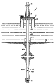
[0013] FIGURE I depicts one exemplary LWD tool suitable for use in accordance
with
aspects of this invention.
[0014] FIGURE 2 depicts a flowchart of one exemplary method embodiment of this
invention.
[0015] FIGURE 3 depicts in schematic form a cross section of an exemplary LWD
tool
suitable for use in accordance with aspects of this invention.
[0016] FIGURE 4 depicts an exemplary Bartlett window function.
CA 02503225 2005-04-18
9
DETAILED DESCRIPTION
[0017) FIGURE i schematically illustrates one exemplary embodiment of a
logging
while drilling tool 100 according to this invention in use in an offshore oil
or gas drilling
assembly, generally denoted 10. In FIGURE 1, a semisubmersible drilling
platform 12 is
positioned over an oil or gas formation (not shown) disposed below the sea
floor 16. A
subsea conduit 18 extends from deck 20 of platform 12 to a wellhead
installation 22. The
platform may include a derrick 26 and a hoisting apparatus 28 for raising and
lowering
the drill string 30, which, as shown, extends into borehole 40 and includes a
drill bit 32
and LWD tool 100. LWD tool 100 typically includes at least one LWD sensor 120
and
an azimuth sensor 130 deployed thereon. LWD sensor 120 may include
substantially any
downhole logging sensor, for example, including a natural gamma ray sensor, a
neutron
sensor, a density sensor, a resistivity sensor, a formation pressure sensor,
an annular
pressure sensor, an ultrasonic sensor, an audio-frequency acoustic sensor, and
the like.
Azimuth sensor 130 may include substantially any sensor that is sensitive to
its azimuth
on the tool (e.g., relative to high side), such as one or more accelerometers
and/or
magnetometers. Drill string 30 on FIGURE 1 may further include a downhole
drill
motor, a mud pulse telemetry system for communicating with the surface, and
other
logging and/or measurement while drilling tools, such as surveying tools,
formation
sampling tools, drill string steering tools, and the like.
[0018] It will be understood by those of ordinary skill in the art that the
LWD tool 100
of the present invention is not limited to use with a semisubmersible platform
12 as
illustrated in FIGURE 1. LWD tool 100 is equally well suited for use with any
kind of
subterranean drilling operation, either offshore or onshore.
CA 02503225 2005-04-18
[0019] In the embodiment shown in FIGURE 1, the LWD sensor 120 and the azimuth
sensor 130 are longitudinally spaced and deployed at substantially the same
azimuthal
(circumferential) position on the tool 100. It will be appreciated that this
invention is not
limited to any particular layout (positioning) of the LWD sensor 120 and the
azimuth
sensor 130 on the tool 100. For example, in an alternative embodiment (not
shown) the
LWD and azimuth sensors may be deployed at substantially the same longitudinal
position, but be circumferentially offset from one another. It will also be
appreciated that
while the embodiment shown on FIGURE 1 includes a single LWD sensor 120 and a
single azimuth sensor 130, that this invention is not limited to any
particular number of
LWD and azimuth sensors.
[0020] LWD tool 100 may further optionally include an energy source (not
shown).
For example, an LWD tool configured for azimuthal gamma measurements may
include a
gamma radiation source (such a device is typically referred to as a density
measurement
device). Likewise, LWD tools configured for azimuthal resistivity and acoustic
velocity
measurements may include one or more electromagnetic wave generators and
acoustic
transmitters, respectively. The invention is not limited, however, to the use
of an energy
source since the LWD sensor 120 may be utilized to measure naturally occurring
formation parameters (e.g., a natural gamma ray sensor may be utilized to
measure
azimuthally sensitive natural gamma ray emissions).
[0021] With continued reference to FIGURE l, downhole tool 100 typically
further
includes a controller (not shown), e.g., having a programmable processor (not
shown),
such as a microprocessor or a microcontroller and processor-readable or
computer-
readable program code embodying logic. A suitable processor may be utilized,
for
example, to construct images (as describal in more detail below) of the
subterranean
CA 02503225 2005-04-18
11
formation based on azimuthally sensitive sensor measurements and associated
azimuth
and measured depth information. Images of the earth formation may indicate
physical
properties (e.g., resistivity, dielectric constant, acoustic velocity,
density, etc.) of the
surrounding formation and/or the materials comprising the strata. A suitable
controller
may also optionally include other controllable components, such as sensors
(e.g., a depth
sensor), data storage devices, power supplies, timers, and the like. The
controller may
also be disposed to be in electronic communication with sensors 120 and 130. A
suitable
controller may also optionally communicate with other instruments in the drill
string,
such as, for example, telemetry systems that communicate with the surface. A
typical
controller may further optionally include volatile or non-volatile memory or a
data
storage device.
[0022] Turning now to FIGURE 2, one exemplary embodiment of a method 200
according to this invention is illustrated. LWD tool 100 rotates 202 with the
drill string in
the borehole (e.g., with drill string 30 in borehole 42 shown on FIGURE 1 ).
Logging data
204 and azimuth data 206 are measured by LWD sensor 120 and azimuth sensor 130
(FIGURE 1 ), respectively, during rotation of the tool 100. The logging and
azimuth data
may be correlated 208 such that each data point in the sequence of logging
data points is
assigned an azimuth. The correlated data may then be convolved 210 with a
predetermined window function (such as a Bartlett function as described in
more detail
below) at a plurality of azimuthal positions about the circumference of the
tool and the
result transmitted to the surface and/or stored in memory. As described in
more detail
below, convolution with a window function enables the sensor data to be, for
example,
over sampled and/or weighted based on its associated azimuth. Such convolution
thus
CA 02503225 2005-04-18
12
tends to advantageously improve image quality via reducing statistical
measurement noise
and image distortion (as compared to prior art binning techniques).
[0023] In general an image may be thought of as a two-dimensional
representation of a
parameter value determined at discrete positions. For the purposes of this
disclosure,
borehole imaging may be thought of as a two-dimensional representation of a
measured
formation (or borehole) parameter at discrete azimuths and borehole depths.
Such
borehole images thus convey the dependence of the measured formation (or
borehole)
parameter on the borehole azimuth and depth. It will therefore be appreciated
that one
purpose in forming such images of particular formation or borehole parameters
(e.g.,
formation resistivity, dielectric constant, density, acoustic velocity, etc.)
is to determine
the actual azimuthal dependence of such parameters as a function of the
borehole depth.
Determination of the actual azimuthal dependence may enable a value of the
formation
parameter to be determined at substantially any arbitrary azimuth, for example
via
interpolation. The extent to which a measured image differs from the actual
azimuthal
dependence of a formation parameter may be thought of as image distortion.
Such
distortion may be related, for example, to statistical measurement noise
and/or other
effects, such as aliasing. Nevertheless, it will be appreciated that
minimizing image
distortion advantageously improves the usefulness of borehole images in
determining the
actual azimuthal dependence of such borehole parameters.
[0024] With reference now to FIGURE 3, a schematic of a cross section of a
downhole
tool (e.g., tool 100 shown on FIGURE 1) is shown. The tool includes a sensor
120' (such
as a gamma ray sensor) deployed thereon. In general, the borehole (or the
circumference
of the tool) may be represented by a plurality of discrete azimuthal
positions. Typically,
embodiments including 8 to 32 azimuthal positions are preferred (the
embodiment shown
CA 02503225 2005-04-18
13
in FIGURE 3 includes 16 discrete azimuthal positions denoted as 0 through 15).
However, the invention is not limited in this regard, as substantially any
number of
discrete azimuthal positions may be utilized. It will be appreciated that
there is a tradeoff
with increasing the number of azimuthal positions. Image quality (and in
particular
azimuthal resolution) tends to improve with increasing number of azimuthal
positions at
the expense of requiring greater communication bandwidth between the downhole
tool
and the surface and/or greater data storage capacity. Furthermore,
conventional binning
techniques may lead to a degradation of the statistical properties of the
binned data as the
number of azimuthal positions increases. The prior art is characterized by a
tradeoff
between the number of azimuthal positions and the statistical variations
available among
the measured logging data.
[0025] With continued reference to FIGURE 3, and assuming that the azimuthal
positions are uniformly distributed about the circumference of the tool, the
azimuth at
each discrete azimuthal position, ~k, and the subtended circular angle between
adjacent
azimuthal positions, 0~, may be expressed mathematically, for example, as
follows:
~k = p k + ~~ p - IJ, k = 0,..., p - 1 Equation 1
2n
Equation 2
P
[0026] where the subscript k is used to represent the individual azimuthal
positions and
p represents the number of azimuthal positions about the circumference of the
tool.
While the above equations assume that the azimuthal positions are evenly
distributed
about the circumference of the tool, the invention is not limited in this
regard. For
example, if a heterogeneity in a formation is expected on one side of a
borehole (e.g.,
CA 02503225 2005-04-18
14
from previous knowledge of the strata), the azimuthal positions may be chosen
such that
A~ on that side of the tool is less than A~ on the opposing side of the tool.
[0027] As described briefly above, exemplary embodiments of this invention
include
convolving azimuthally sensitive sensor data with a predetermined window
function. The
azimuthal dependence of a measurement sensitive to a formation parameter may
be
represented by a Fourier series, for example, shown mathematically as follows:
F(~) _ ~ fv exp(iv~) Equation 3
[0028] where the Fourier coefficients, f~ , are expressed as follows:
f~ = 2~ f F(~) exp(-iv~)d~ Equation 4
[0029] and where ~ represents the azimuth about the circumference of the tool,
F(~)
represents the azimuthal dependence of a measurement sensitive to a formation
(or
borehole) parameter, and i represents the square root of the integer -1.
[0030] Given a standard mathematical definition of a convolution, the
convolution of
the sensor data with a window function may be expressed as follows:
Fk =F(~k)= 2~+f F(~)W(~k -~)d~ Equation 5
(0031] where ~ and F(~) are defined above with respect Equation 4, Fk and
F(~k)
represent the convolved sensor data stored at each discrete azimuthal
position, and
W(~k -~) represents the value of the predetermined window function at each
discrete
azimuthal position, ~~ , for a given azimuth, ~ . For simplicity of
explanation of this
embodiment, the window function itself is taken to be a periodic function such
that
CA 02503225 2005-04-18
IS
W(~)=W(~+2~d) where I=...,-1,0,+1,..., is any integer. However, it will be
appreciated that use of periodic window functions is used here for
illustrative purposes,
and that the invention is not limited in this regard.
[0032] Based on Equations 3 through 5, it follows that:
Fk = ~ fvw,, exp(iv~k ), k = 0,..., p - 1 Equation 6
[0033] where from Equation 2:
wv = 2~ JW(~)exp(-iv~)d~ Equation 7
-n
[0034] where wv represents the Fourier coefficients of W(~), fv represents the
Fourier
coefficients of F(~) and is given in Equation 4, W(ø) represents the azimuthal
dependence of the window function, and, as described above, F(~) represents
the
azimuthal dependence of the measurement that is sensitive to the formation
parameter. It
will be appreciated that the form of Equation 6 is consistent with the
mathematical
definition of a convolution in that the Fourier coefficients for a convolution
of two
functions equal the product of the Fourier coefi~icients for the individual
functions.
[0035) It will be appreciated that embodiments of this invention may utilize
substantially any window function, W(~). Suitable window functions typically
include
predetermined values that are expressed as a function of the angular
difference between
the discrete azimuthal positions, ~k , and an arbitrary azimuth, ~ . For
example, in one
exemplary embodiment, the value of the window function is defined to be a
constant
within a range of azimuth angles (i.e., a window) and zero outside the range.
Such a
window function is referred to as a rectangular window function and may be
expressed,
for example, as follows:
CA 02503225 2005-04-18
16
hI < x~
' P
W (~) = 0, P <_ ~ < ~c Equation 8
-~<~<-x~
P
[0036] where p represents the number of azimuthal positions for which
convolved
logging sensor data is determined, ~ represents azimuth, and x is a factor
controlling the
azimuthal breadth of the window function W(~) . While Equation 8 is defined
over the
interval - ~c <_ ~ < ~, it is understood that W(~) has the further property
that it is
periodic: W (~) = W (~ + 2ni) for any integer l .
[0037] In certain embodiments it may be advantageous to utilize tapered and/or
symmetrical window functions. A Bartlett function (i.e., a triangle function),
such as that
shown on FIGURE 4, is one example of a symmetrical and tapered window function
that
is relatively simple and thus a good choice for illustrating exemplary
advantages of this
invention. As shown in FIGURE 4 and as used herein, a symmetrical window
function is
one in which the value of the window function is an even function of its
argument. A
tapered window function is one in which the value of the window function
decreases with
increasing angular difif'erence, ~ ~k -~ ~, between a discrete azimuthal
position, ~k, and an
azimuth, ~ . It will be appreciated that such tapered window functions tend to
weight the
measured sensor data based on its corresponding azimuth, with sensor data
acquired at or
near an azimuth of ~k being weighted more heavily than sensor data acquired at
an
azimuth further away from ~k . Setting ~k = 0, one exemplary Bartlett window
function
may be expressed, for example, as follows:
2~(1 - X~~~ ~ ~~~ < sn
~?' P
W (~) = 0, p < ~ < ~ Equation 9
0,
P
CA 02503225 2005-04-18
17
[0038] where p, ~, and x are as described above with respect to Equation 8. In
Equation
9, W(~) has the same exemplary periodicity mentioned in the discussion of
Equation 8.
[0039] In addition to the Bartlett function described above, other exemplary
symmetrical and tapered window functions include, for example, Blackman,
Gaussian,
Harming, Hamming, and Kaiser functions, exemplary embodiments of which are
expressed mathematically as follows in Equations 10, 11, 12, 13, and 14,
respectively:
2np~0.42+O.Scos(P4)+0.08cos(2P~)~ ~~I< p
W (~) - 0, P <_ ~ < ~c Equation I 0
0' -~~~~-n
exp( as (p~ )2 ~ ~~~ < n
W (~) = 0, p 5 ~ < ~ Equation 11
~ < ~ < , sn
n
~(~ + cos( x~ )~ h1 < p
W (~) = 0, ~ <_ ~ < ~r Equation 12
0~ _~<~<_XA
r
2np~0.54 + 0.46cos~p4)~ ICI < p
W (~) = 0, p < ~ < ~ Equation 13
0~ _~<~<_xA
n
I (Pn ~2
h~ < p
lo(~a)
W(~) = 0, p 5 ~ < ~ Equation 14
0' -~~~~- n
[0040) where p, x, and ~ are as described above with respect to Equation 8,
and as
represents another factor selected to control the relative breadth of the
window function,
CA 02503225 2005-04-18
18
such as, for example, the standard deviation of a Gaussian window function.
Typically,
as is in the range from about 1 to about 2. to represents a zero order
modified Bessel
function of the first kind and ~o represents a further parameter that may be
adjusted to
control the breadth of the window. Typically, ~a is in the range from about ~
to about
2~r . It will be appreciated that Equations 8 through 14 are expressed
independent of ~k
(i.e., assuming ~k = 0 ) for clarity. Those of ordinary skill in the art will
readily recognize
that such equations may be rewritten in numerous equivalent or similar forms
to include
non zero values for ~k . In Equations 10-14, all the functions W(~) also have
the same
exemplary periodicity mentioned in the discussion of Equations 8 and 9.
[0041] In one exemplary serviceable embodiment of this invention, an energy
source
(e.g., a gamma radiation source) emits energy radially outward and in a
sweeping fashion
about the borehole as the tool rotates therein. Some of the gamma radiation
from the
source interacts with the formation and is detected at a gamma ray detector
within the
borehole. Typically the detector is also rotating with the tool. The sensor
may be
configured, for example, to average the detected radiation (the azimuthally
sensitive
sensor data) into a plurality of data packets, each acquired during a single
rapid sampling
period. The duration of each sampling period is preferably significantly less
than the
period of the tool rotation in the borehole (e.g., the sampling period may be
about 10
milliseconds while the rotational period of the tool may be about 0.5
seconds).
Meanwhile, the azimuth sensor measures the azimuth of the tool, and
correspondingly the
gamma ray sensor, as the tool rotates in the borehole. An azimuth is then
assigned to
each data packet. The azimuth is preferably measured for each sampling period,
or often
enough so that the azimuth of the tool may be determined for each sampling
period,
CA 02503225 2005-04-18
19
although the invention is not limited in this regard. In one exemplary
embodiment, the
assigned azimuth may be expressed mathematically, for example, as follows:
Y'(t j ) -'Y(t j_I ) - ZRCj
yj = ~(tj ) - 2 + 2~cb j Equation 15
[0042] where yj represents the assigned azimuth and ~(tj ) and ~(tj _, )
represent the
sensor azimuth at times tj and tj_, , respectively. Additionally, a rapid data-
sampling
period, Otj, equals t; -tj_, . Equation 15, as written, uses the convention
that
- ~ < ~(tj ) <- ~ . Thus, cj equals zero if ~(tj ) and ~(tj_, ) have the same
sign, otherwise,
cj equals +1 if ~(tj ) >_ 0 and c j equals -1 if ~(tj ) < 0. The constant bj =
~1 in Equation
15 is selected to ensure that - ~ < yj < ~ . It will be appreciated that the
invention is not
limited in this regard and that Equation I S could be rewritten using
substantially any
other convention.
[0043] The contribution of each data packet to the convolved sensor data given
in
Equation 5 may then be expressed as follows:
2~ F(yj)W(~k - yj), k=0,..., p-1 Equation 16
[0044] where F(yj) represents the measured sensor data at azimuth yj and as
described above W (~k - yj ) represents the value of the predetermined window
function at
each assigned azimuth yj .
[0045] Sensor data for determining the azimuthal dependence of the formation
parameter (e.g., formation density) at a particular well depth is typically
gathered and
grouped during a predetermined time period. The predetermined time period is
typically
CA 02503225 2005-04-18
significantly longer (e.g., one thousand times) than the above described rapid
sampling
time. Summing the contributions to Equation 16 from N such data packets
yields:
Fk = 1 ~F(Yf)~'(~k -Y;), 1r=0,...,p-1 Equation 17
2nlV ;_,
[0!!46] where F~ represents the convolved sensor data stored at each discrete
azimuthal
position as described above with respect to Equation S. The sum is normalized
by the
factor 1/N so that the value of Fk is independent of N in the large N limit.
[0047] In the exemplary embodiment described, Fk , as given in Equation 17,
represents
the convolved sensor data for a single well depth. To form a two dimensional
image
(azimuthal position versus well depth), sensor data may be acquired at a
plurality of well
depths using the procedure described above. In one exemplary embodiment,
sensor data
may be acquired substantially continuously during at least a portion of a
drilling
operation. Sensor data may be grouped by time (e.g., in 10 second intervals)
with each
group indicative of a single well depth. In one exemplary embodiment, each
data packet
may be acquired in about 10 milliseconds. Such data packets may be grouped in
about 10
second intervals resulting in about 1000 data packets per group. At a drilling
rate of
about 60 feet per hour, each group represents about a two-inch depth interval.
It will be
appreciated that this invention is not limited to any particular rapid
sampling and/or time
periods. Nor is this invention limited by the description of the above
exemplary
embodiments.
[0048] It will also be appreciated that embodiments of this invention may be
utilized in
combination with substantially any other known methods for correlating the
above
described time dependent sensor data with depth values of a borehole. For
example, the
CA 02503225 2005-04-18
21
Fk values obtained in Equation 17 may be tagged with a depth value using known
techniques used to tag other LWD data. The Fk values may then be plotted as a
function
of azimuthal position and depth to generate an image.
CA 02503225 2005-04-18
22
COMPARISON WITH PRIOR ART BINNING TECHNIQUES
[0049] As described above, one objective of azimuthal imaging is the
determination of
the actual azimuthal dependence F(~) of a measurement that is sensitive to a
formation
(or borehole) parameter. In the discussion that follows it will be shown that
exemplary
embodiments of this invention reduce statistical measurement noise and image
distortion
effects as compared to prior art binning techniques. Embodiments of this
invention thus
advantageously tend to produce superior images as compared to the prior art.
[0050] As described above, the prior art discloses methods for binning sensor
data in a
range of anywhere from about four (quadrants) to about 16 azimuthal sectors.
As the tool
rotates about its longitudinal axis, data are acquired by a sensor and grouped
into various
sectors based on the azimuth of the sensor. During subsequent revolutions
sensor data
grouped into any particular sector is essentially averaged with sensor data
acquired during
previous revolutions. Prior art methods further assume that the azimuthal
sectors do not
overlap one another and are essentially the same size (e.g., eight sectors
each subtending
an arc of 45 degrees). Based on such prior art binning techniques, an
azimuthal angle, ~s ,
and the subtended circular angle, 0~, of each azimuthal sector may be
expressed
mathematically, for example, as follows:
~s = 2n s + ~c~ n -1 ~, s = 0, . . ., n - 1 Equation 18
2n
Equation 19
n
[0051] where the subscript s is used to represent the individual azimuthal
sectors and n
represents the number of azimuthal sectors.
~
CA 02503225 2005-04-18
23
[0052] The prior art technique of binning sensor data into the above-described
azimuthal sectors may be closely approximated mathematically by the following
expression.
_ 1 c~.+o~iz>
Fs = F(~s) _ - jF(~)d~ Equation 20
~~ cm.-e~~2~
[0053] where Fs and F(~f ) represent the average value of the sensor data
stored in a
particular azimuthal sector (or bin), the subscript s (as described above) is
used to
represent the individual azimuthal sectors, ~s and 0~ represent the azimuthal
angle and
subtended circular angle, respectively, of each azimuthal sector, and F(~) ,
as described
above, represents a mathematical function of the measured borehole parameter
with
respect to the azimuth ~ . Thus, for example, the average value of the
measured sensor
data stored in bin s = 0, Fo , may be described as being approximately equal
to the
integral of the function F(~) evaluated from ~o - 0~ / 2 to ~o + 0~ / 2
divided by 0~ .
[0054] Substituting Equations 3, 18, and 19 into Equation 20 leads to the
following
mathematical expression:
Fs = ~ (-1) -" f" ex~ l2aw(s + 1) ~ sincC ?rv ~, s = 0,. .., n - 1 Equation 21
"_ ~ _ l n n
[0055] where, as described above, the subscript s is used to represent the
individual
azimuthal sectors, n represents the number of azimuthal sectors, FS represents
the
average value of the sensor data stored in azimuthal sector s, and f"
represents the
Fourier coefficients. Additionally, sinc(x) = sin(x)/x such that:
CA 02503225 2005-04-18
24
nv
n sinC n
sine-~ = Equation 22
n ~v
[0056] As shown, Equation 21 includes a set of n simultaneous equations having
an
infinite number of unknowns, namely Fourier coefficients fv . As described
above (and
as shown in Equations 3 and 4), the function of interest, F(~) , may be
determined from
the Fourier coefficients, f" . Thus, the function F(~) may be determined from
the binned
data, FS , to the extent that the Fourier coefficients, f", may be determined
from Equation
21. Given that Equation 21 includes an infinite number of Fourier
coefficients, f", their
direct determination is not possible from the binned data, F . In order to
estimate F(~)
from the binned data, FS , it is necessary to truncate the set of equations
given in Equation
21 and solve for a limited number of unknowns (e.g., the lower order Fourier
coefficients). For example, such a truncated set of Equations may be expressed
mathematically, for example, as follows:
F = 1 " ex sinc , s = 0,..., n - 1 E uation 23
~ ) f" ~i2nv(s+1)~ ~~~ q
"=-~"-pi2 n n
[0057] where n, s, and FS are as described above with respect to Equation 21,
and f"
represents approximations to the Fourier coefficients, f" . The f" values may
then be
utilized to approximate F(~) as described above in Equations 3 and 4.
[0058] It will be appreciated that the Fourier coefficients, f", in Equation
21 are
multiplied by a factor proportional to 1 / v (as shown in Equation 22). As
such, the higher
order Fourier coefficients (such as v = 7, 8, 9...) tend to be weighted
significantly and in
turn adversely at~ect an accurate determination of the lower order Fourier
coefficients of
' CA 02503225 2005-04-18
F(~) . Thus, image distortion caused by prior art binning techniques tends to
be
significant and often results in poor quality images. The above-described
image
distortion (which results mathematically from under-sampling a discrete
Fourier Series) is
typically referred to as aliasing by those of skill in the digital signal
processing arts. As
shown and described above, such an abasing effect (as caused by prior art
binning
techniques) tends to result in distorted (e.g., coarse and grainy) images.
While the image
distortion caused by aliasing may be reduced via increasing the number of
azimuthal
sectors (bins), such an approach is typically limited by downhole data storage
and/or
communication bandwidth constraints. Furthermore, improvements in image
quality
achievable via simply increasing the number of azimuthal sectors is limited
since the
Fourier coefficients fy, in Equation 21 are multiplied by a factor
proportional to 1 / v .
[0059] It will also be appreciated that prior art binning techniques do little
to reduce
measurement noise (with the exception of averaging the sensor data in each
azimuthal
sector). As is well known to those of ordinary skill, downhole measurements
(and in
particular azimuthally sensitive measurements) may include statistical
variations and
significant measurement noise (due in part to the extreme downhole
environment), which
often reduces the quality of borehole images. As such, reduction of
measurement noise
may advantageously improve the quality and utility of borehole images.
[0060] In contrast to the prior art binning techniques, and as described
above,
exemplary embodiments of this invention include convolving sensor data with a
window
function. As will now be shown, embodiments of this invention advantageously
reduce
image distortion caused by both aliasing et~ects and measurement noise. This
may be
shown, for example, by substituting the Bartlett window function given in
Equation 9 into
Equation 7 and setting x equal to 2, which yields:
" CA 02503225 2005-04-18
26
Fk = ~ (-1)" f" ex~ l2aiv(k + 1) sincz ~ ~~ k = 0,..., p-1 Equation 24
"=-m _ l P P
[0061] where, as described above, the subscript k is used to represent the
individual
azimuthal positions, and p represents the number of azimuthal positions for
which
convolved logging sensor data is determined. Additionally, Fk represents the
convolved
sensor data stored at each azimuthal position k, f" represents the Fourier
coefficients, and
sinc(x) = sin(x)/x such that:
p2 sin2C P
sinc ~'~~ _ ~2 Z Equation 25
P
(0062] It will be appreciated that Equation 24 is similar to Equation 21 in
that it
includes a set of simultaneous equations having an infinite number of
unknowns. Thus,
as described above with respect to Equation 21, it is possible to estimate
F(~) from the
convolved sensor data F~ by truncating the set of equations given in Equation
24 and
solving for the lower order Fourier coefficients. However, it will also be
appreciated that
Equation 24 converges more rapidly than Equation 21 since it includes the
factor
sincz(~cv/ p) . As such the Fourier coefFcients, f", in Equation 24 are
multiplied by a
factor proportional to 1 l vz (as shown in Equation 25). Thus, in contrast to
the prior art
binning techniques, truncating the set of equations in Equation 24 tends not
to introduce
significant aliasing errors since the higher order Fourier coefficients tend
not to contribute
significantly to an accurate determination of F(~) . As such, exemplary
embodiments of
this invention, in which the sensor data is convolved with a window function
(such as one
of the symmetrical tapered window functions described above), are shown to
CA 02503225 2005-04-18
27
advantageously significantly reduce aliasing effects as compared to the prior
art binning
techniques.
[0063] Evaluating the convolution of the sensor data with a window function at
p' = 2p azimuthal positions, for example, may enable the imaging system to
reduce the
effects of statistical measurement noise in addition to reducing aliasing
effects. As such,
the convolution is evaluated such that ~k - ~k _, _ ~r l p = (~S - ~s _~ ) / 2
, where ~S is defined
in Equation 18. Substituting the Bartlett window function given in Equation 9
into
Equation 7 and setting x equal to 2 yields:
*'° i~cv(k + 1) 2 ~tv
Fk = ~(-1)" f" ex sinc - , k = 0,...,2p -1 Equation 26
P ~2P
[0064] where k, p, Fk, and f" are as described above with respect to Equation
24.
[0065] Equation 26 is substantially identical to Equation 24 with the
exception that it
includes p' = 2 p equations, rather than p equations. The system of equations
shown in
Equation 26 is essentially over determined (i.e., includes more equations than
unknowns)
when truncated analogously to the system of equations shown in Equation 23. As
such,
the effect of statistical measurement noise on the estimate of the Fourier
coefficients, f"
(and therefore F(~) ), tends to be reduced as compared to prior art binning
techniques. In
addition, aliasing effects are also reduced by the sinc2(nv/(2p))factor as
described above
with respect to Equation 24. It will be appreciated that Equation 26 may also
be truncated
such that it includes a greater number of terms (since it includes 2p rather
than p
equations), thereby enabling aliasing effects to be even further reduced as
compared to
the prior art.
CA 02503225 2005-04-18
28
[0066] It will be appreciated that exemplary embodiments of this invention may
be
advantageously utilized to determine a formation (or borehole) parameter at
substantially
any arbitrary azimuth. For example, Fourier coefficients of the azimuthal
dependence a
formation parameter may be estimated as described above with respect to
Equations 24 or
26. A Fourier series including at least one Fourier coefficient may then be
utilized to
determine a value of the formation parameter at substantially any azimuth ~.
The Fourier
coefficients) may also be utilized to estimate F(~) as described above with
respect to
Equations 3 and 4.
[0067] In the preceding examples, a Bartlett window function is utilized to
demonstrate
that exemplary embodiments of this invention tend to advantageously reduce
aliasing
effects and the effect of statistical measurement noise as compared to prior
art binning
techniques. Moreover, embodiments of this invention advantageously enable such
abasing effects to be decoupled from statistical measurement noise and
therefore, as
described above, may be advantageously utilized in LWD imaging applications.
It will
be appreciated that this invention is not limited in any way by such examples,
but rather,
' as described above may include the use of substantially any window function
having
substantially any azimuthal breadth.
[0068] It will be understood that the aspects and features of the present
invention may
be embodied as logic that may be processed by, for example, a computer, a
microprocessor, hardware, firmware, programmable circuitry, or any other
processing
device well known in the art. Similarly the logic may be embodied on software
suitable
to be executed by a processor, as is also well known in the art. The invention
is not
limited in this regard. The software, firmware, and/or processing device may
be included,
for example, on a downhole assembly in the form of a circuit board, on board a
sensor
CA 02503225 2005-04-18
29
sub, or MWD/LWD sub. Alternatively the processing system may be at the surface
and
configured to process data sent to the surface by sensor sets via a telemetry
or data link
system also well known in the art. Electronic information such as logic,
software, or
measured or processed data may be stored in memory (volatile or non-volatile),
or on
conventional electronic data storage devices such as are well known in the
art.
[0069] Although the present invention and its advantages have been described
in detail,
it should be understood that various changes, substitutions and alternations
can be made
herein without departing from the spirit and scope of the invention as defined
by the
appended claims.