Note: Descriptions are shown in the official language in which they were submitted.
CA 02511447 2005-07-05
- 1 -
STABLE HELI-BORNE VECTOR PLATFORM
FOR PERFORMING GEOPHYSICAL MEASUREMENTS
TECHNICAL FIELD
t0001~ The present invention relates to a stable heli-
borne vector platform for performing geophysical
measurements over a surface area.
BACKGROUND ART
tooo2~ Airborne geophysical measurements depend on the
use of a stable platform that is precisely located
geographically, able to incorporate sensors aligned in three
orthogonal directions, and able to follow the topography
closely, without any disturbance, especially from the towing
craft.
tooo3l Therefore, the platform needs to be situated at
a sufficient distance from the towing craft so as to be free
of its field of influence. It needs to be stable, in the
sense that any pitch, roll or yaw movements are minimized so
that the wanted signal is not affected significantly. Such
measurements are most commonly taken using fixed-wing
aircraft, but these craft do not fully satisfy the criteria
of separation from the platform, or that of being able to
closely follow the topography. The helicopter, on the other
hand, is able to fully satisfy these two criteria.
tooo4~ Most geophysical methods require differential
measurements, in other words, they record components of the
signal through the use of suitably distanced sensors capable
of measuring the rate of change of the signal. When this
rate of change is measured in three orthogonal directions,
these measurements can be used to calculate the resultant
vector, called the total gradient. In general, this value
contains more information than the actual field value,
mostly because it allows one to remove uncertainties due to
approximations, for example those due to the distance of the
i ,
CA 02511447 2005-07-05
- 2 -
base station from the sensors in the case of magnetic
measurements.
~0005~ Magnetic gradiometer measurements are one of the
possible applications of the platform presented here. It is
the method most suitable for describing the principals used,
and is hence used to illustrate the advantages of the
present platform.
The first trials to produce such a system began
in the 1960's for magnetic field measurements. References
are herein provided to map some history of airborne magnetic
gradiometry measuring systems.
Papers by Hood, P.J., 1965 (Gradient
Measurements in Aeromagnetic Surveying; Geophysics, Vol. 30,
p. 891-902) and Hood, P.J. and Teskey, D.J., 1989
(Aeromagnetic Gradiometer Program of the Geological Society
of Canada, Geophysics, Vol. 54, p. 1012-1022), describe
existing systems through a retrospective examination.
Papers by Hood, P.J. and Teskey, D.J. 1987 (Helicopter-borne
Aeromagnetic Gradiometer Surveys: A Progress Report, in
Current Research, Part A. Geol. Surv. Can., Paper 87-lA, p.
935-938), show the advantages of differential measurements
for mineral prospecting.
~0008~ Thus, in 1984 at least four systems were known
to exist for this activity. All of them were built based on
the same model, as presented in Figure 2 of the paper by
Hood, P.J. and Teskey, D.J., 1987 (Helicopter-borne
Aeromagnetic Gradiometer Surveys: A Progress Report, in
Current Research, Part A. Geol. Surv. Can., Paper 87-1A, p.
935-938) , that of a "bird" at the end of a tow-cable (towed
bird), above which a vertical mast around 2 metres in length
is usually attached.
To summarize, the principal characteristics of
this model comprise one main longitudinal axis; a secondary
vertical axis placed above the main axis, and a pulling
point located above the group formed by these two axes.
i ,
CA 02511447 2005-07-05
- 3 -
The various models proposed subsequently are in
fact simply variants of the model described above, since
they all use a main longitudinal axis - the bird - above or
below which a vertical axis is attached. The two most
commonly described models were initially proposed by Gamey,
J.T., Holladay, J.S. and Mahler, R., 1997 (Airborne Measured
Analytic Signal for UXO Detection, Environmental and
Engineering Geophysical Society (EEGS), SAGEEP proceedings,
from 853 and onwards), and by Berger, Z., Davies, J.,
Thompson, R.T., McConnell, T.J., Lo B., Ryder-Turner, A. and
MacKay, P., 1999 (Exploration Applications of Three
Dimensional Gradient Magnetics in the Western Canada
Sedimentary Basin and the Fold Best Region, Reservoir,
September 1999), and finally by Siegel, H.O., McConnell,
T.J. and Ryder-Turner, A., 2001 (Method and Apparatus for
Detecting Locating and Resolving Buried Pipelines, Cased
Wells and Other Ferrous Objects, United States Patent,
Patent No.: US 6,255,825 B1, Date of Patent July 3, 2001).
Ioooll~ The last publication above claims both a
methodology and a system for the detection and positioning
of ferrous magnetic objects. The claimed methodology is
based on the use of the "analytical signal", as is commonly
known through the work of Nabighian, published in 1972
(Nabighian, M. N., 1972, The Analytic Signal of Two-
dimensional Magnetic Bodies With Polygonal Cross-Section:
Its Properties and Use for Automated Anomaly Interpretation:
Geophysics, Vol. 37 (3), p. 507-517) and more recently by
Roest, W.R., Verhoef, J., and Pilkington, M., in 1992
(Roest, W.R., Verhoef, J., Pilkington, M., 1992, Magnetic
Interpretation Using the 3-D Analytic Signal: Geophysics,
Vol. 57 (1), p. 116-125). Its application for ferrous
magnetic object detection has been previously presented by
Gamey, J.T., Holladay, J.S. and Mahler, R. in 1997 (Airborne
Measured Analytic Signal for UXO Detection, Environmental
and Engineering Geophysical Society (EEGS), SAGEEP
proceedings, from 853 and onwards).
CA 02511447 2005-07-05
- 4 -
~oooi27 The system described in the paper by Siegel,
H.O., McConnell, T.J. and Ryder-Turner, A., 2001 makes use
of the three main characteristics as originally published by
Hood, P.J. and Teskey, D.J., 1987 (Helicopter-borne
Aeromagnetic Gradiometer surveys: A Progress Report, in
Current Research, Part A, Geol. Surv. Can., Paper 87-lA, p.
935-938).
SUMMARY OF INVENTION
~o00i3~ It is a feature of the present invention to
provide a stable heli-borne vector platform for performing
geophysical measurements over a surface area, and is
comprised of sensors oriented in three orthogonal
directions. To do so, there is provided a horizontal
lateral boom, a horizontal longitudinal boom and a vertical
boom. The vector platform is stabilized by a weight secured
at a lower end of a vertical boom and a drag tail assembly
is secured to a rear section of the horizontal longitudinal
boom. Instruments are installed at opposite ends of the
lateral boom, at the rear of the longitudinal boom, and each
end of the vertical boom.
~ooola7 The lateral and vertical booms are disposed in a
common plane. The lateral boom has symmetrical boom
sections projecting from opposite sides of a central housing
disposed on the horizontal longitudinal boom. Sensors are
secured at opposite ends of these boom sections and at the
top ends of the vertical boom. A stabilizing weight is
secured at the lower end of the transverse vertical boom. A
drag tail assembly is secured to the rear section of the
horizontal longitudinal boom. Electronic components are
placed in the central housing for receiving data from the
instruments. An attachment point is provided on each of the
lateral boom sections for attachment of a traction means
thereto and securable to a tow cable, attached to the
helicopter.
r
i
CA 02511447 2005-07-05
- 5 -
BRIEF DESCRIPTION OF DRAWINGS
~o0015~ A preferred lay-out of the present invention
will now be described with reference to the accompanying
drawings in which:
I00oi6~ FIGURE 1 is a perspective view showing the
stable vector platform secured to a helicopter and with the
platform disposed at a ground resting position;
Io0o17~ FIGURE 2 is a perspective view, partly
fragmented, showing the stable heli-borne vector platform in
its towing position with the lateral pulling boom being
constituted by a rigid wing boom; .
~00018~ FIGURE 3 is a perspective view similar to Figure
2 but wherein the lateral pulling boom is constituted by
rigid rod members;
t00o19~ FIGURE 4 is a front view of the vector platform
showing the symmetry thereof; and
~00020~ FIGURE 5 is a side view of the vector platform
illustrated in Figure 3.
DESCRIPTION OF PREFERRED EMBODIMENTS
Io0o21~ Referring now to the drawings and more
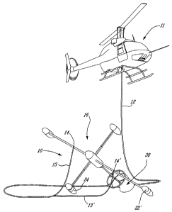
particularly to Figure 1, there is shown generally at 10,
the stable heli-borne vector platform of the present
invention which is secured to a helicopter 11 by a tow cable
12 which is attached to traction means in the form of a pair
of identical sling arms 13 and 13' which are respectively
secured to tow attachment points 14 and 14' secured to the
vector platform 10.
~00022~ With additional reference to Figures 2 to 5,
there will be described the detailed construction of the
vector platform 10. As shown in these Figures, the vector
platform is comprised of a horizontal longitudinal boom 15,
a transverse lateral boom 16 and a vertical boom 17. The
lateral boom 16 is disposed in a common plane 18 with the
vertical boom 17, as illustrated in Figure 5.
CA 02511447 2005-07-05
- 6 -
foo023~ The horizontal lateral boom 16 has symmetrical
boom sections 19 and 19' which project from opposite sides
of a central housing 20 which is disposed on the horizontal
longitudinal boom. The lateral boom sections are identical,
and are connected to the central housing 20, which
constitutes the attachment hub for all the boom sections.
These lateral boom sections 19 and 19' are illustrated in
Figure 2 as being rigid elements shaped as a wing profile,
the shape of which does not provide lift to the vector
platform during normal airborne flying conditions but
provides rigidity and reduces flexing moments.
fooo24~ The opposite ends of the transverse boom
sections 19 and 19' are fitted with different sensors 21
(see Figure 2) depending on the type of survey being
performed by the vector platform. These sensors are herein
shown as being magnetic field sensors and these are located
in sensor housings (pods) 22 and 22' spaced approximately 6
metres apart. Only one sensor is herein shown for
illustration purposes. Further sensors are located in
sensor housings 22" + 24 secured to the top and bottom ends
of the vertical boom 17. For magnetic measurements, a
separation of 3 metres between the sensors is desirable.
fooo25~ The vertical boom also has a lower section 17"
with a stabilizing weight secured thereto. This stabilizing
weight can be removably secured inside the lower sensor
housing 24 in the form of metal discs, herein bronze discs
25, placed either side of the vertical boom 17. The number
of these discs may vary depending on the required weight for
particular wind conditions. This weight keeps the
transverse vertical boom aligned vertically and forces the
horizontal components to keep a horizontal alignment when
towed.
foo026~ A drag tail assembly 30 is also secured to the
end of the main horizontal boom 15. As herein shown, the
drag tail assembly 30 is of aerodynamic design and is
comprised of a hollow tapered cylinder 31 herein provided by
a
CA 02511447 2005-07-05
_ 7 _
a fabric material which is held on a support framework 32
which is secured to the horizontal longitudinal boom 15.
The tapered cylinder 31 tapers from the open front end 33 to
the open rear end 34 allowing the passage of air
therethrough as the vector platform is dragged by the
helicopter such as illustrated in Figure 5, when in full
flight. This tapering of the cylinder 31 creates a
resistance which causes the vector platform to orient itself
in the direction of pull as indicated by arrow 35 in Figure
2.
fo0o2'7~ The central housing 20 is a profiled housing
having a dome-shaped nose section 36 and a like rear dome
section 37, both of which are removably secured for access
to the inside of the housing. As herein shown, a further
housing 38 is secured to the rear of the horizontal
longitudinal boom 15 to house further electronic circuitry
or equipment or further sensing devices. Depending on the
nature of the measurements, this housing can be moved along
the longitudinal boom 15 from the rear of the housing 20 to
the end of the boom 15. The vertical boom sections 17' and
17" are also herein shown as being detachably secured to
interchange with booms of different lengths depending on the
application of the vector platform. They could also be
telescopically constructed. The instruments or sensors feed
information or data to electronic components 39 housed
within the central housing 20. This data may be recorded in
that housing or may be transmitted to the towing aircraft
via the tow cable for recording in portable devices for
later access. It is also conceivable that they could be
transmitted to remote receiving stations.
~0o028~ As shown in Figure 3, the lateral pulling boom
16 consists of rigid rod members 40 and 40' of similar
construction to the vertical boom rod members 17' and 17".
These rod members 40, 40', 17' and 17" may be made up of two
sections with the outer sections being removably secured to
one of transverse connector tubes 41 secured to the housing
n
CA 02511447 2005-07-05
20. These tubes 41 may have holes therein (not shown) and
securement pins (also not shown but obvious to a person
skilled in the art) to effect an adjustable connection of
these rigid rod members whereby to construct a symmetrical
boom arrangement, as more clearly illustrated in the front
view of Figure 4. The sections 17' and 17" may also have a
wing profile identical to that illustrated in 19 and l9'.
(oooa9~ The central housing 20 is also fitted with a
DGPS (differential global positioning system) antenna 42
which is secured to the top wall section of the central. An
altimeter antenna 43 is similarly secured to the housing 20
at the bottom wall section thereof. Such devices are
required to effect airborne geophysical measurements. In
order to record variations in pitch, roll, and yaw, a multi-
antenna GPS system can be installed.
~00030~ In order to tow the vector platform in space,
there are provided tow attachment points 14 and 14' secured
to the opposite symmetrical lateral boom sections 19 and 19'
and 40 and 40' at equidistant points from the longitudinal
axis. These provide for the attachment of a traction means
in the form of a pair of identical sling arms 13 and 13'.
These sling arms are constructed of rigid rope material or
other suitable material and joined at the forward end 46
where a ring connector may be provided whereby to secure the
tow cable 12 thereto, as illustrated in Figure 1. This tow
cable is approximately 30 metres in length, so that the
helicopter is maintained at a sufficient distance so as not
to interfere with the sensors.
~00031~ With reference again to Figure 1, it can be seen
that the particular design of the vector platform provides
for an apparatus which is easy to land on a ground surface
by a helicopter. It is also easy to manually transport.
Because of the stabilizing weight 25, the platform will
always land with the weight touching the ground surface
first and then, as it is gently lowered to the ground, it
will articulate sidewards and rearwards with one of the
a
CA 02511447 2005-07-05
- 9 -
sensor housings 22, 22' of the lateral boom 16 also resting
on the wground as well as the drag tail assembly 30. As can
be seen, the vector platform 10 is stable on the ground and
always points upwards in a ready-to-tow position. The
helicopter can then land a sufficient distance away from the
vector platform.
Iooo32~ Briefly summarizing the principal
characteristics of the stable heli-borne vector platform 10
of the present invention, it is pointed out that it
encompasses a horizontal longitudinal boom 15, a horizontal
lateral pulling boom 16 disposed in a common plane with a
vertical boom 17 and a stabilizing weight 25 located at the
base of the vertical boom acting as a vertical reference. A
pulling point 46 is located in front of the vector platform
and symmetrically secured to the lateral pulling boom on
opposite sides of a central housing 20 which houses various
electronic components and which also acts as a mechanical
link between the boom members. With this type of
symmetrical design the vector platform, when towed, reduces
vibrations caused by motion through the air, thus allowing
the sensitivity of modern sensors to be fully exploited.
When .disposed on the ground, the vector platform rests on
three points, namely the stabilizing weight, one of the
sensor housings of the lateral boom and the drag tail
assembly 30, and points upwards in a ready-to-tow position.
Iooo33~ It is within the ambit of the present invention
to cover any other obvious modifications of the preferred
embodiment described herein, provided such modifications
fall within the scope of the appended claims.