Note: Descriptions are shown in the official language in which they were submitted.
CA 02511878 2005-06-27
Description
Title of the Invention
A traffic information providing system, a traffic information
representation method and apparatus therefor.
Technical Field
The present invention relates to a system for providing traffic
information such as congestion and travel time, a method of representing the
traffic information, and apparatus constituting the system, and in particular
to
such a system, a method and apparatus capable of correctly transmitting the
information contents in providing data of traffic information.
Further, the invention relates to a method of representing various
information associated with roads, such as road traffic information and path
information, a system for generating, displaying and utilizing the
information,
and apparatus constituting the system, and in particular to such a system, a
method and apparatus capable of displaying the reliability and superiority of
information.
Background Technology
VICS (Vehicle Information and Communication System) which
currently provides a car navigation system with a traffic information
providing
system collects and edits traffic information and transmits traffic congestion
information and travel time information representing the time required by way
of an FM- muatipa~x broadcast-or.-a beacon. - __ _ _ _ -_ _ - _. .
The current VICS information represents the current traffic information
as follows: . - .
Traffic situation is displayed in three levels, congestion (ordinary road:
<-_10 kmlh; expressway: X20 km/h);
heavy traffic (ordinary road: 10-20 km/h; expressway: 20-40 km/h); and light
traffic (ordinary road: ?20 km/h; expressway: >-_40 km/h).
The traffic congestion information representing the traffic congestion is
displayed as
"VICS link number+state (congestion/heavy traffic/light
traffic/unknown)" in case the entire VICS link (position information
identifier
used by VICS) is congested uniformly.
In case only part of the link is congested, the traffic congestion
information representing the traffic congestion is displayed as
"VICS link number+congestion head distance (distance from beginning
1
CA 02511878 2005-06-27
of link)+congestion end (distance from beginning of link)+state (congestion)"
In this case, when the congestion starts from the start end of a link, the
head congestion distance is displayed as 0xff. In case different traffic
situations coexist in a link, each traffic situation is respectively described
in
accordance with this method.
The link travel time information representing the travel time of each link
is displayed as
"VICS link number+travel time"
As prediction information representing the future change trend of traffic
situation, an increase/decrease trend graph showing the four states, "increase
trend/decrease trend/no change/unknown" is displayed while attached to the
current information.
VICS traffic information displays traffic information while identifying a
road with a link number. The receiving party of this traffic information
grasps
the traffic situation of the corresponding road on its map based on the link
number. The system where the sending party and receiving party shares link
numbers and node numbers to identify a position on the map requires
introduction or a change in new link numbers and node numbers each time a
road is constructed anew or changed. With this, the data on the digital map
from each company needs updating so that the maintenance requires huge
social costs.
In order to offset these disadvantages and transmitting a road position
independently of a VICS number, the inventor of the invention proposes, in
Japanese Patent Laid-Open No. 2001-41757 and. Japanese Patent Laid
-Open No. 2001-66146, a system where a sending party arbitrarily sets a
plurality of nodes on a road shape and transmits a "shape vector data string"
representing the node position by a data string and a receiving party uses the
shape vector data string to perform map matching in order to identify a road
on
a digital map.
The inventor also proposes a method of presenting traffic information
based on the philosophy which represents the state volume of traffic
information changing along a road.
This method generates traffic information as follows:
As shown in Fig. 23A, a shape vector (road) having a distance of X m
is equidistantly segmented from a reference node by a unit block length
(Example: 50-500 m) to perform sampling. As shown in Fig. 23B, the average
speed of a vehicle passing through each sampling point is obtained. In Fig.
23B, the value of the obtained speed is shown in a square representing the
2
CA 02511878 2005-06-27
quantization unit set through sampling. In this case, the average travel time
or congestion rank of a vehicle passing through each sampling interval may be
obtained instead of the average speed.
Next, the data string of the speed value is encodedlcompressed in
order to reduce the volume of data used to transmit the traffic information.
The compression coding may use approaches such as the variable length
coding (Huffman/arithmetic code/Shannon-Fano, etc.) and discrete wavelet
transform (DWT).
The encoded traffic information is transmitted together with the shape
vector data string information (Fig. 24A) representing the road shape of the
target road, as shown in Figs. 24A and 24B. The traffic information data (Fig.
24B) includes, on top of encoded data of traffic information, information used
to
identify the target road section in association with the shape vector data
string
information, as well as information on number of quantization units, length of
unit block, and encoding system.
A receiving party which has received the above information decodes
the encoded shape vector data and performs map matching on its own digital
map data in order to identify the target road section on its own map and
decode the encoded traffic information to represent the traffic information on
the target road section.
The Japanese Patent Application 2002-89069 develops the above
philosophy and proposes a method of presenting traffic information which
represents the state volume of traffic information changing along a road.
- - . .This.-method generates traffic information as follows: -
As shown in Fig. 34A; a shape vector (road) having a distance of X m
is equidistantly segmented from a reference node by a unit block length
(Example: 50-500 m) to perform sampling. As shown in Fig. 34B, the average
speed of a vehicle passing through each sampling point is obtained. In Fig.
34B, the value of the obtained speed is shown in a square representing the
quantization unit set through sampling. In this case, the average travel time
or congestion rank of a vehicle passing through each sampling interval may be
obtained instead of the average speed.
Next, the speed value is converted to a quantized volume by using the
traffic information quantization table shown in Fig. 35. In the traffic
information quantization table, in response to the user's request for detailed
information of congestion, setting is made so that the quantized volume will
increase in steps of 1 km/h in case the speed is less than 10 km/h, 2 km/h in
case the speed is within the range of 10 to 19 km/h, 5 km/h in case the speed
3
CA 02511878 2005-06-27
is within the range of 20 to 49 km/h, and 10 km/h in case the speed is equal
to
or more than 50 km/h. Quantized values obtained using the traffic information
quantization table are shown in Fig. 34C.
Next, the quantized volume is represented by a difference from the
statistical prediction value. In this example, difference between the
quantized
speed Vn in the target quantization unit and a quantized speed Vn-1 in the
upstream quantization unit or statistical prediction value S is calculated by
using (Vn - Vn-1 ). The calculation result is shown in Fig. 34D.
In case the quantized value is represented by a difference from the
statistical prediction value, frequency of appearance of values around ~0
becomes higher because traffic situation is similar between adjacent
quantization units.
Variable length encoding is performed on the data thus processed.
That is, past traffic information is analyzed and an encoding table for
encoding
the statistical prediction difference value of traffic information is created,
as
shown in Fig. 36. By using the encoding table, the value in Fig. 34D is
encoded. For example, +2 is encoded to "1111000" while -2 is encoded to
"1111001 ". In case 0 continues, such as 00000, the data is encoded to "100".
In this way, by quantizing the traffic information and converting the
quantized value to a statistical prediction value and increasing the frequency
of
values appearing around ~0, the effect of data compression through variable
length encoding (Huffman/arithmetic code/Shannon-Fano, etc.) or run-length
compression (run-length encoding) is enhanced. In particular, in case the
congestion information is displayed in ranks of four levels as-in the related
art,
the statistical prediction difference value in most quantization units is 0 so
that
the effect of run-length compression is very high.
The traffic information thus encoded is, as shown in Figs. 37A and 37B,
formed into the data having the data structure of Fig. 37B, together with the
shape vector data string information representing a road shape, and is then
transmitted. On top of the information, a shape vector encoding table, a
traffic
information quantization table (Fig. 35), and an encoding table of statistical
prediction difference values of traffic information (Fig. 36) are transmitted
in the
same occasion or over a separate route.
The receiving party which has received the above information decodes
the shape vector in each traffic-information-provided section and pertorms map
matching on its own digital map data in order to identify the target road
section
on its own map and decode the traffic information on this target road section
while referencing the encoding table.
4
CA 02511878 2005-06-27
By doing so, the receiving party can reproduce the traffic information
changing along a road (traffic information represented in a function of
distance
from a reference node).
The state volume f traffic information changing along a road (Fig. 34B)
can be converted to several waveforms having separate frequency
components for the receiving party to reproduce the state volume of traffic
information even in case the coefficient value of each frequency is provided.
The conversion to frequency components uses approaches such as
FFT (Fast Fourier Transform), DCT (Discrete Cosine Transform), and DWT
(Discrete Wavelet Transform). For example, the Fourier Transform technique
can obtain a Fourier coefficient C(k) from a finite number of discrete values
(state volume) represented in a complex function f by way of Expression 1
(Fourier Transform).
C(k)=(1/n) Ef(j) ~ cu-jk (k=0, 1,2,...,n-1)
( E means sum from j=0 to n-1 ) (Expression 1 )
When C(k) is given, a discrete value (state volume) is obtained by way
of Expression 2(Inverse Fourier Transform).
F(j)=~C(k) ~ c~jk(j=0, 1,2,...,n-1)
means sum from k=0 to n-1 )
(Expression 2)
A party which provides traffic information converts the state volume of
traffic information..to n (=2N) coefficients and quantizes the coefficient.
The
value obtained through the quantization is obtained as follows: a coefficient
of
a low frequency is divided by 1; as a coefficient pertains to a higher
frequency,
a larger value than 1 is used to divide the coefficient by, and the fraction
is
rounded off. The quantized value is compressed through variable length
compression and is then transmitted. In this case, the data structure of
traffic
information is as shown in Fig. 38.
The receiving party which has received the traffic information decodes
and dequantizes the coefficient and reproduces the state volume of traffic
information by using Expression 2.
In this way, in case traffic information is converted to a coefficient of a
frequency component before it is transmitted, adjusting the value to be
divided
in quantization obtains a wide range of data from "transmit data with a large
volume of information which provides correct reproduction accuracy of traffic
information" to "transmit data with a small volume of information which
5
. CA 02511878 2005-06-27
provides lower reproduction accuracy of traffic data". In case coefficient
information is transmitted layer by layer in ascending order of frequency, the
receiving party obtains an outline of the image when it has obtained the
information of the coefficient of a lower frequency before obtaining the
entire
data even when the transmission speed is low. In an early level, the receiving
party can determine whether the traffic information is "required or not" and
in
case not require, skip the information.
Traffic changes with time. As time elapses from the point in time
traffic is measured, reliability of traffic information drops. On a road where
sensors to measure traffic situation (ultrasonic vehicle sensors, loop coil
sensors, image sensors, etc.) are densely installed, traffic can be measured
with high accuracy. On the other hand, on a road where such sensors are
sparsely installed, measurement accuracy of traffic is lowered, with lower
reliability of traffic information.
In this way, reliability of traffic information is not uniform but depends
on time and location. There has never been a service which provides traffic
information together with its reliability.
The user thus has difficulty in correctly evaluating the presented traffic
information. The user, encountering a scene where the provided traffic
information is different from the actual situation, may feel an unwanted sense
of distrust to the overall traffic information.
The user empirically understands the natural congestion of a road
where the/she uses for commuting and expects "the speed of the flow of cars
and how-long will-it-take- to get out of congestion" but cannot make a. guess -
when the/she has encountered an abrupt congestion due to an accident or
construction. Thus, the information indicating" whether the current traffic is
more congested than usual in terms of the user's daily experience" or
information indicating "whether the congestion will be worse or better" is
quite
useful when the user selects his/her route.
VICS provides "event information" in order to notice an abrupt event.
This represents "an accident," "a construction," "a control (such as lane
control
and road closing)," "road abnormalities (road blocking due to cave-in,
submersion in water, or collapse of peripheral facilities such as trees and
buildings)," and "weather (in particular snowfall and icy road." A driver who
has acquired such information can select another road.
It is difficult to gather the event information by way of a sensor. In
general, an operator in a center manually enters or deletes information based
on the information transmitted over the telephone, etc. to the center.
6
CA 02511878 2005-06-27
Checkup of the credulity of the information and management of information via
human intervention is cumbersome so that only a small part of information
which has a large influence is input or provided.
A large number of related art car navigation units mount a feature to
perform path search while considering the added congestion information. A
service is provided where, in response to information on a start point and a
destination transmitted to the center, information on the recommended path
from the center which has searched for routes and the destination is received.
Such path search approaches use a link cost modified based on congestion
information to calculate a recommended path. Unknown reliability of the
congestion information will make an adverse effect on the result of path
search.
A shortest-time route calculated based on the link cost alone is not
necessarily a desirable one to the driver. A driver will generally wish to
choose a familiar, frequented route provided the route has a small time
difference from the shortest-time route. On the other hand, in case the time
difference is large, the driver will wish to use the shortest-time route. In
order
for the driver to select a route based on such psychological background,
additional information which compares the retrieved route and the familiar
route is required. The related art path search techniques do not provide such
additional information.
It is expected that a service to offer traffic information on a chargeable
basis will be available. Traffic information with lower reliability which
costs the
user the same charge as traffic information with higher reliability will
alienate- .
the user.
In the related art method of representing traffic information, it is difficult
to appropriately represent, without degrading the accuracy of information, an
"unknown" section caused by a faulty vehicle sensor or absence of
information.
Representation of "an unknown section" may include a method of
defining a value as "invalid traffic information." When irreversible
compression is made to traffic information, the value of an "unknown" section
changes from the value of "invalid traffic information." An example of this is
representing a quantized traffic state volume in a difference from the
statistical
prediction value. In this case, when the value Vn-1 of the upstream
quantization unit is subtracted from the quantization unit value Vn in
question
to obtain a statistical prediction value S being (Vn - Vn-1 ), the value of
the
"unknown" section changes from the value of "invalid traffic information."
7
CA 02511878 2005-06-27
In case the state volume of traffic information is represented in a
coefficient of a frequency component, conversion/inverse conversion of the
frequency component smoothes values in the "unknown" section and values in
the sections preceding and following the section or approximates those values.
This may cause a value to drift from a value of "invalid traffic information"
or
cause a value in the section preceding or following the section to change with
the value in the "unknown" section. When a large value which could not exist
is
used to represent "invalid", the dynamic range is enhanced so that the overall
error is extended.
Disclosure of the invention
The invention solves the foregoing related art problems and has an
object to provide a representation method of representing traffic information
and path information together with its reliability and superiority and
apparatus
and a system which generate, display and utilize the traffic information and
path information having such attribute information.
The invention has another object to provide a traffic information
providing system capable of communicating an "unknown" section to a
receiving party and a method of representing traffic information, and
apparatus
constituting the system.
To this end, the invention represents road-related information such as
traffic information and path information together with gray scale information
which displays the attributes of the information in multiple levels.
The gray scale.information is a representation, in more. than one-level, .
of some characteristics of the provided road-related information such as
traffic
information and path information and some auxiliary information to help the
user of the information determine the information more precisely.
The user can utilize the gray scale information to understand the
reliability of the provided road-related information and superiority of the
provided path information.
The invention displays the reliability of the state volume of traffic
information in multiple levels by way of the gray scale information.
The user thus understands how reliable the traffic information is and is
able to correctly evaluate the traffic information.
The invention displays the difference of the state volume of traffic
information from that in ordinary traffic by way of the gray scale
information.
The user thus understands that the current traffic is as usual or that an
abrupt, unpredictable state is there.
8
CA 02511878 2005-06-27
The invention displays the change in the state volume of the traffic
information in multiple levels by way of the gray scale information.
The user thus understands whether the congestion is becoming worse
or better.
The invention displays the superiority of a shortest-travel-time path
over a reference path in multiple levels.
The user can make selection: in case a shortest-travel-time path is
provided, the user selects the shortest-travel-time path in a higher-
superiority
section and a familiar, frequented path in a tower-superiority section.
The invention provides the terminal apparatus with reception means for
receiving gray scale information which displays the state volume of traffic
information and the attribute of the shortest-time route in multiple levels
and
display means for displaying the state volume of traffic information in a form
corresponding to the value of gray scale information.
The user thus recognizes the reliability of traffic information and an
unpredictable traffic state from the display on the terminal apparatus.
The invention provides the terminal apparatus with transmission
means for transmitting the information on the current location and the
destination, reception means for receiving the path information and the gray
scale information to displays the superiority of the path information in
multiple
levels, and display means for displaying the path information in a form
corresponding to the value of gray scale information.
On the terminal apparatus, information on the current location and the
destination is-transmitted and path information is provided. - The -user--.can
determine whether to follow the provided path information based on the
superiority of the path information.
The invention provides the terminal apparatus with reception means for
receiving traffic information, route calculation means for calculating a
shortest-travel-time path from the current location to the destination while
referencing the traffic information, attribute information calculation means
for
generating the gray scale information to display the superiority of the
shortest-travel-time path in multiple levels, and display means for displaying
the shortest-travel-time path in a form corresponding to the value of gray
scale
information.
The terminal apparatus can receive traffic information and generate the
path information to the destination and corresponding gray scale information.
The invention provides the path information calculation apparatus with
dynamic link cost calculation means for calculating the dynamic link cost for
a
9
CA 02511878 2005-06-27
link based on the state volume of traffic information, static link cost
calculation
means for calculating the static link cost for the link, static link cost
provision
means for providing the static link cost for the link, and link cost
determination
means for changing the distribution ratio of the dynamic link cost and static
link
cost based on the gray scale information which represents the reliability of
the
superiority of traffic information in multiple levels in order to generate a
link
cost used for path calculation.
The path information calculation apparatus can properly set a link cost
so that it is possible to perform path search at high accuracy.
The traffic information providing system of the invention comprises
traffic information providing apparatus for retaining, as traffic information,
the
state volume of traffic information and gray scale information which displays
the reliability of the state volume in multiple levels and providing traffic
information to which the gray scale information is appended, and client
apparatus for receiving the traffic information from the traffic information
providing apparatus, in order for the traffic information providing apparatus
to
set the value of traffic information to be provided to the client apparatus in
accordance with the gray scale information appended to the traffic
information.
This system provides a reasonable charging system in which, traffic
information with a higher accuracy costs the user a higher change. While
traffic information with a lower accuracy costs the user a lower change.
The traffic information providing system of the invention comprises
traffic information providing apparatus for providing, as traffic information,
the
state volume of -traffic- information at each of the sampling points set by --
segmenting a target road and mask bit information indicating that the state
volume is valid or invalid, and traffic information utilization apparatus for
receiving the traffic information and reproducing the valid state volume by
using the mask bit information.
The receiving party thus correctly identifies the "unknown" section
based on the mask bit information.
The traffic information providing apparatus of the invention comprises a
traffic information converter for converting the state volume of traffic
information changing along a road to an array of the values of sampling points
set by segmenting the target road and generating an array of mask bits
representing the validity or invalidity of the values of the sampling points,
an
encoder for encoding the data generated by the traffic information converter
from the state volume of the traffic information and the data of mask bit
information, and an information transmitter for transmitting the data encoded
CA 02511878 2005-06-27
by the encoder.
The traffic information utilization apparatus comprises an information
receiver for receiving, from the traffic information providing apparatus, the
encoded data concerning the state volume of the traffic information of the
target road, the encoded data of mask information representing the validity or
invalidity of the state volume, and road section reference data to identify
the
target road, a decoder for decoding each item of said encoded data and
reproducing the valid state volume from the state volume of the traffic
information and the mask bit information, and a determination section for
performing map matching by using the road section reference data to identify
the target road of traffic information.
The traffic information providing apparatus and the traffic information
utilization apparatus may be used to constitute the traffic information
providing
system of the invention.
The traffic information display method of the invention sets sampling
points by segmenting the target road of traffic information, sets 1 s of mask
bit
information in correspondence with the sampling points where valid state
volumes of traffic information are obtained and sets Os of mask bit
information
in correspondence with the sampling points where valid state volumes of
traffic
information are not obtained, and presents an array of mask bit information
together with an array of state volumes of these sampling points.
Thus, the receiving party which has received the traffic information
correctly identifies an "unknown" section base on the mask bit information.
Brief Description--of-the-.Drawings -. -
Fig. 1A shows data used to implement a traffic information
representation method according to a first embodiment of the invention;
Fig. 1 B shows data used to implement a traffic information
representation method according to the first embodiment of the invention;
Fig. 2A is a printout of a figure showing the color-display traffic
information representation method according to the first embodiment of the
invention, where the reliability of a state volume is presented in the degree
of
watermark of a color line;
Fig. 2B is a printout of a figure showing the color-display traffic
information representation method according to the first embodiment of the
invention, where the reliability of a state volume is presented in the
thickness
of a color line;
Fig. 2C is a printout of a figure showing the color-display traffic
information representation method according to the first embodiment of the
11
CA 02511878 2005-06-27
invention, where the reliability of a state volume is presented in
solid/dashed
color lines;
Fig. 3 shows a loop coil sensor;
Fig. 4 shows an ultrasonic sensor;
Fig. 5 shows an image sensor;
Fig. 6 is a block diagram showing a configuration of a gray scale
information generating section according to the first embodiment of the
invention;
Fig. 7 is block diagram showing a configuration of a path information
calculator according to a second embodiment of the invention;
Fig. 8 is block diagram showing a configuration of a traffic information
providing system according to a third embodiment of the invention;
Fig. 9 shows a change in the travel time during an abrupt congestion;
Fig. 10 is a block diagram showing the system configuration according
to a fourth embodiment of the invention;
Fig. 11 is a flowchart showing a processing procedure in the system
according to the fourth embodiment of the invention;
Fig. 12 illustrates alienation of a measured value from an average of
statistical value;
Fig. 13A shows a data structure of traffic information transmitted by the
system according to the fourth embodiment of the invention, where position
reference information is shown;
Fig. 13B shows a data structure of traffic information transmitted by the
system according to the fourth embodiment of the invention, where encoded
traffic information is shown;
Fig. 14 is a block diagram showing a configuration of a system
according to a fifth embodiment of the invention;
Fig. 15 is a flowchart showing a processing procedure in the system
according to the fifth embodiment of the invention;
Fig. 16 is a block diagram showing a configuration of a system
(CDRGS) according to a seventh embodiment of the invention;
Fig. 17 is a flowchart showing a processing procedure in the system
(CDRGS) according to the seventh embodiment of the invention;
Fig. 18A shows a data structure of traffic information transmitted by the
system according to the seventh embodiment of the invention, where position
reference information of a route is shown;
Fig. 18B shows a data structure of path information transmitted by the
system according to the seventh embodiment of the invention, where attribute
12
CA 02511878 2005-06-27
information is shown;
Fig. 19 is a printout of a figure (color) showing the display form of a
provided route in the seventh embodiment of the invention;
Fig. 20 is a flowchart showing another processing procedure in the
system (CDRGS) according to the seventh embodiment of the invention;
Fig. 21 is a block diagram showing a configuration of a system
(LDRGS) according to the seventh embodiment of the invention;
Fig. 22 is a flowchart showing a processing procedure in the system
(LDRGS) according to the seventh embodiment of the invention;
Fig. 23A illustrates related art traffic information;
Fig. 23B illustrates related art traffic information;
Fig. 24A shows a data structure of related art traffic information, where
shape vector data string information is shown;
Fig. 24B shows a data structure of related art traffic information, Where
traffic information is shown;
Fig. 25A shows a method of representing traffic information according
to an eighth embodiment of the invention, where encoded/compressed
information is schematically shown;
Fig. 25B shows a method of representing traffic information according
to the eighth embodiment of the invention, where decoded information is
schematically shown;
Fig. 25C shows a method of representing traffic information according
to the eighth embodiment of the invention, where traffic information
reproduced
using the decoded-information is schematically shown; --. - -_
Fig. 26 is block diagram showing a configuration of a traffic information
providing system according to the eighth embodiment of the invention;
Fig. 27 is a flowchart showing an operation of the traffic information
providing system according to the eighth embodiment of the invention;
Fig. 28 is a flowchart showing another operation of the traffic
information providing system according to the eighth embodiment of the
invention;
Fig. 29 shows a data structure of traffic information according to the he
eighth embodiment of the invention;
Fig. 30A illustrates data setting in a section where traffic information is
unknown according to the eighth embodiment of the invention;
Fig. 30B illustrates data setting in the section where traffic information
is unknown according to the eighth embodiment of the invention;
Fig. 30C illustrates data setting in the section where traffic information
13
~
~ CA 02511878 2005-06-27
is unknown according to the eighth embodiment of the invention;
Fig. 30D illustrates data setting in the section where traffic information
is unknown according to the eighth embodiment of the invention;
Fig. 31A illustrates road section reference data according to the eighth
embodiment of the invention;
Fig. 31 B illustrates road section reference data according to the eighth
embodiment of the invention;
Fig. 31 C illustrates road section reference data according to the eighth
embodiment of the invention;
Fig. 32 is a block showing a traffic information providing system
according to a ninth embodiment of the invention;
Fig. 33 shows a data structure of transmit data (an example of format
of transmit data from a probe car to a center) in the traffic information
providing
system according to the ninth embodiment of the invention;
Fig. 34A illustrates related art traffic information;
Fig. 34B illustrates related art traffic information;
Fig. 34C illustrates related art traffic information;
Fig. 34D illustrates related art traffic information;
Fig. 35 shows a speed quantization table used to quantize related art
traffic information;
Fig. 36 shows an encoding table (an example of an encoding table of
statistical prediction values of traffic information) used in encoding of
related
art traffic information;
Fig. 37A shows a data structure of related art traffic information, where
shape vector data string information (encodedlcompressed data) is shown;
Fig. 37B shows a data structure of related art traffic information, where
traffic information is shown; and
Fig. 38 shows another data structure (an example of FFT-represented
traffic information) of related art traffic information.
Reference numerals throughout the figures represent:
10: Traffic information measurement apparatus; 11: Sensor processor A; 12:
Sensor processor B; 13: Sensor processor C; 14: Traffic information
calculator;
15: Traffic information transmitter; 21: Sensor A (ultrasonic vehicle sensor);
22:
Sensor B (image sensor); 23: Sensor C (probe car); 30: Traffic
information/attribute information generatorltransmitter; 31: Current traffic
information collector; 32: Statistical information accumulating section; 33:
Traffic information converter; 34: Encoder; 35: Information transmitter; 36:
Digital map database A; 37: Attribute information generator; 38: Attribute
14
~
CA 02511878 2005-06-27
information calculator; 40: Route calculator; 60: Receiving party apparatus;
61:
Information receiver; 62: Decoder; 63: Position reference section; 64: Traffic
informationlattribute information processor; 65: Digital map database B; 66:
Link cost table; 67: Information utilization section; 68: Local vehicle
position
determination section; 69: GPS antenna; 70: Gyroscope; 71: Guidance
apparatus; 72: Travel locus accumulating section; 73: Information transmitter;
74: Reference information determination section; 75: Reference information
input MMI; 76: Wiper; 77: Current position/destination setting section; 78:
Destination input MMI; 79: Route information/attribute information utilization
section; 80: Gray scale information generator; 81: Traffic information
accumulating section; 82: Gray scale information calculator; 83: Definition
table; 84: Statistical traffic information generator; 85: Prediction
information
generator; 86: Traffic information editing section; 87: Bypath information
generator; 88: Probe car measurement information generator; 89: Statistical
traffic information database; 90: Sensor A traffic determination section; 91:
Sensor Z traffic determination section; 92: Probe car traffic determination
section; 93: Bypath information database; 100: Path information calculator;
101: Traffic information receiver; 102: Dynamic link cost calculator; 103:
Path
calculation condition determination section; 104: Link cost determination
section; 105: Map database; 106: Path calculation link cost accumulating
section; 107: Path calculator; 108: Path calculation result transmitter; 120:
Traffic information transmitter/information charge calculator; 121: Traffic
information database; 122: Traffic information transmission area/target road
determination- section; 123: Request information receiver; 124:. Information
charge determination section; 125: Traffic information editing section; 126:
Traffic information transmitter; 127: Charge database; 130: Client apparatus;
131: Request information transmitter; 132: Information request area/target
road determination section; 133: Input operation section; 134: Traffic
information receiver; 135: Decoder; 136: Traffic information utilization
section;
137: Digital map database; 180: MMI section; 181: Traffic information
receiver;
182: Route calculator; 183: Attribute information calculator; 300:
Route/attribute information calculator/transmitter; 1010: Traffic information
measurement apparatus; 1011: Sensor processor A; 1012: Sensor processor
B; 1013: Sensor processor C; 1014: Traffic information calculator; 1021:
Sensor A (ultrasonic vehicle sensor); 1022: Sensor B (AVI sensor); 1023:
Sensor C (probe car); 1030: Traffic information transmitter; 1031: Traffic
information collector; 1032: Quantization unit determination section; 1033:
Traffic information converter; 1034: Encoder; 1035: Information transmitter;
CA 02511878 2005-06-27
1036: Digital map database; 1050: Encoding table creating section; 1051:
Encoding table calculator; 1052: Encoding table; 1053: Traffic information
quantization table; 1054: Distance quantization unit parameter table; 1060:
Receiving party apparatus; 1061: Information receiver; 1062: Decoder; 1063:
Map matching and section determination section; 1064: Traffic information
reflecting section; 1066: Link cost table; 1067: Information utilization
section;
1068: Local vehicle position determination section; 1069: GPS antenna; 1070:
Gyroscope; 1071: Guidance apparatus; 1080: Probe car collection system;
1081: Travel locus measurement information utilization section; 1082: Encoded
data decoder; 1083: Travel locus receiver; 1084: Encoding table transmitter;
1085: Encoding table selector; 1090: Probe-car-mounted machine; 1091:
Travel locus transmitter; 1092: Encoder; 1093: Local vehicle position
determination section; 1094: Encoding table receiver; 1095: Encoding table
data; 1096: Travel locus measurement information accumulating section; 1097:
Measurement information valid/invalid determination section; 1098: Sensor
information collector; 1101: GPS antenna; 1102: Gyroscope; 1103: Sensor X;
1104: Sensor Y; 1105: Sensor Z; 1106: Sensor A; 1107: Sensor B; 1108:
Sensor C
Best Mode for Carrying Out the Invention
Embodiments of the application will be described referring to drawings.
(First embodiment)
Concerning the first embodiment of the invention, a method of
generating gray scale information is described below: -- -
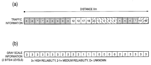
As shown in Figs. 1A and 1 B, traffic information such as congestion
information, travel time information and speed information is presented in
traffic information representing traffic information changing along a road in
the
state volume of sampling points (state volume of distance quantization unit)
(Fig. 1A) and gray scale information representing the reliability of the state
volume of each sampling point (Fig. 1 B). Set interval of said sampling points
is not necessarily the same for the state volume of traffic information and
gray
scale information. For example, gray scale information on a single point may
be defined for a plurality of sampling points of state volume, or separate
number of sampling points may be specified for the state volumes and gray
scale information in the same section, without departing from the object of
the
invention.
In this example, gray scale information is represented in four levels
(two bits). A state having the highest reliability is represented by 3,
followed
1C~
CA 02511878 2005-06-27
by 2, 1 as the reliability becomes lower. 0 represents a faulty vehicle sensor
or an "unknown" state where information is absent.
Based on the information, congestion of a road is displayed on the
map by using color lines as shown in Figs. 1A through 2C. In Figs. 1A
through 3C, a section where the vehicle speed representing the state volume
of distance quantization unit is 10 km/h or below appears in red, 10 to 20
kmlh
in yellow, and 20 km/h or above in green. In Fig. 2A, in case the gray scale
information representing the reliability of the state volume is 3, a color
transmittance of 0 percent is used. In case the gray scale information is 2, a
color transmittance of 33 percent is used. In case the gray scale information
is 1, a color transmittance of 66 percent is used. In Figs. 2A through 2C,
congestion is separately displayed for the up line and down fine. Color (fines
to represent congestion are not used in an unknown section.
In Fig. 2B, in case the gray scale information representing the reliability
of state volume is 3, a bold line is used. In case the gray scale information
is
2, a medium bold line is used. In case the gray scale information is 1, a fine
line is used.
In Fig. 2C, in case the gray scale information is 3, a solid line is used.
In case it is 2, a long dashed line is used. In case it is 1, a short dashed
line
is used.
Factors which determine the value of gray scale information includes
the following:
- Even for the same traffic information (congestion, travel time, etc.),
the value of gray scale information of a road where--sensors .are- densely
installed is high; the value of gray scale information drops as the density of
sensors becomes lower.
- Even for the same traffic information, the value of gray scale
information is higher when the sensor used to determine the traffic is more
accurate; the value of gray scale information drops as the sensor accuracy
becomes lower. The sensor may be a loop coil sensor (Fig. 3), an ultrasonic
sensor (Fig. 4) or an image sensor (Fig. 5). The loop coil sensor (Fig. 3)
counts the number of vehicles which pass over the sensor but cannot identify
the vehicle types, which means the sensor accuracy is low. The image
sensor (Fig. 5) photographs a traveling vehicle with a camera and processes a
shot image to identify the vehicle speed, vehicle type, number of vehicles,
and,
as required, a particular vehicle by way of its license plate, which means
that
the sensor accuracy is high. The ultrasonic sensor emits an ultrasonic wave
from above a vehicle to a road surface and used the reflected wave to
1'7
CA 02511878 2005-06-27
measure the height of the target vehicle. Thus the ultrasonic sensor can
determine the number of vehicles and vehicle types. Its accuracy is medium
when compared with an image sensor and a loop coil sensor.
- Even for the same traffic information, the value of gray scale
information is higher when the variations in the nearest trend are small; the
value of gray scale information drops as the variations become larger. The
"variations in the nearest trend" includes, for example, a variation in the
length
of congestion at the measurement point. In case the length of congestion at
the measurement point gradually changes in a rushing traffic for home,
variations in the trend are small. In case the length of congestion greatly
changes with time, such as congestion caused by short-time construction and
parking/stopping of a large vehicle, variations in the trend are large.
- Even for the same traffic information, the value of gray scale
information is higher when the variations in the past statistics are small;
the
value of gray scale information drops as the variations become larger.
- Even for the same traffic information estimated based on the
detection result of a sensor, the value of gray scale information is higher
when
the difference from the probe information (information such as a travel speed
collected from a traveling vehicle which serves as a probe) is small; the
value
of gray scale information drops as the difference becomes larger.
- Even for the same traffic information, the value of gray scale
information is higher when the variations in the past statistics values are
small;
the value of gray scale information drops as the variations become larger. For
the statistical traffic. information, the value of gray scale is determined
based
on a standard deviation.
-Even for the same estimated information in the absence of information
where information detected by a sensor is not available, the value of gray
scale information is higher when the algorithm of the calculation method is
highly accurate while accompanied by simulation; the gray scale information
value is low when the algorithm of the calculation method is of low accuracy
based on a simple assumption from the preceding and subsequent values.
- Even for the same prediction information (trend prediction) which
predicts traffic in the near future from a trend, the value of gray scale
information is higher when the variations in the nearest trend are small; the
value of gray scale information drops as the variations become larger.
- Even for the same prediction information (statistical prediction) which
predicts traffic in the near future from past statistics, the value of gray
scale
information is higher when the variations in the past statistics are small;
the
18
t CA 02511878 2005-06-27
value of gray scale information drops as the variations become larger.
- Even for the same prediction information, the value of gray scale is
higher when the past percentage of correct answers is high; the value of gray
scale information drops as the percentage becomes lower.
Even for the same probe car measurement information, the value of
gray scale is higher when the time which has elapsed since collection of
information is short (when data is fresh); the value of gray scale information
drops as the time which has elapsed becomes longer.
- Even for the same bypath route information, the value of gray scale is
higher when the effect of selecting the bypath is very great; the value of
gray
scale information drops as the effect becomes smaller.
Fig. 6 shows the configuration of a gray scale information generator 80
for generating gray scale information from the above viewpoints.
The gray scale information generator 80 comprises: a sensor A traffic
determination section 90 for identifying the operation of a sensor A 21 and
collecting the information detected by the sensor A 21; a sensor Z traffic
determination section 91 for identifying the operation of a sensor Z 22 and
collecting the information detected by the sensor Z 22; a probe car traffic
determination section 92 for collecting data from a probe car 23 and
monitoring
the collection state; a traffic information editing section 86 for generating
the
traffic information at the current point in time; a statistical traffic
information
database 89 in which past traffic information is accumulated; a statistical
traffic
information generator 84 for generating statistical traffic information by
using
the-information accumulated in the statistical traffic information-database
89; a
prediction information generator 85 for generating traffic prediction
information
in the near future; a bypath information database 93 in which bypath
information is accumulated; a bypath information generator 87 for generating
bypath information by using the information accumulated in the bypath
information database 93; a probe car measurement information generator 88
for generating probe car measurement information by using the information
collected from a probe car 23; a traffic information accumulating section 81
for
accumulating the traffic inforrnation, prediction information, statistical
traffic
information, bypath information and probe car measurement information
generated by each section, a definition table 83 for quantizing the gray scale
information; and a gray scale information calculator 82 for generating gray
scale information by using the definition table 83.
The traffic information editing section 86 of the gray scale information
generator generates the traffic information at the current point in time by
using
19
~
~ CA 02511878 2005-06-27
the information collected by the sensor traffic determination sections 90, 91
and the probe car traffic determination section 92. The prediction information
generator 85 generates prediction information by using the traffic information
at the current point in time generated by the traffic information editing
section
86 and the statistical traffic information accumulated in the statistical
traffic
information database 89. The bypath information generator 87 generates the
bypath information on a road currently congested by using the information
accumulated in the bypath information database 93.
The statistical traffic information generator 84 statistically analyzes the
information accumulated in the statistical traffic information database 89 to
generate statistical traffic information. The probe car measurement
information generator 88 generates probe car measurement information by
using the information collected from the probe car 23. The traffic information
prediction information, statistical traffic information, bypath information
and
probe car measurement information generated by each section are transmitted
to the traffic information accumulating section 81 and the gray scale
information calculator 82 and are accumulated in the traffic information
accumulating section 81.
The gray scale information calculator 82 uses the definition table 83 to
generate the gray scale information of the above information.
In the definition table 83 are defined gray scale values corresponding
to the installation densities of sensors and sensor types. The gray scale
information calculator 82 determines the gray scale value in each section
-based-on the-installation density of sensors A to Z and-types of the.sensors
A
to Z used by the traffic information editing section 86 to generate traffic
information.
In the definition table 83 are defined gray scale values corresponding
to times lapsed from the time of measurement. The gray scale information
calculator 82 determines the gray scale value in each section based on the
time which has elapsed since measurement of data used by the traffic
information editing section 86 to generate traffic information.
In the definition table 83 are defined gray scale values corresponding
to the variations in the trend of state volume. The gray scale information
calculator 82 determines the gray scale value in each section by calculating
the trend of the state volume of traffic information and checking the
calculated
values against the definition table 83.
In the definition table 83 are defined gray scale values corresponding
to the statistical variations in the state volume. The gray scale information
CA 02511878 2005-06-27
calculator 82 determines the gray scale value in each section by calculating
the statistical variations in the state volume of traffic information in the
section
from the past to present and checking the calculated values against the
definition table 83.
In the definition table 83 are defined gray scale values corresponding
to the deviations of the state volumes obtained from the measurement values
of a sensor from the state volumes obtained from probe information. The
gray scale information calculator 82 calculates the difference between the
state
volume of traffic information and the state volume of probe car information
and
checks the calculated values against the definition table 83 to determine the
gray scale value of traffic information in each section.
The gray scale information calculator 82 calculates the statistical
variations in the state volume of statistical traffic information from the
past to
present and checks the calculated values against the gray scale values
corresponding to the statistical variations in the state volume to determine
the
gray scale value in each section.
In the definition table 83 are defined gray scale values corresponding
to the calculation systems used to estimate a state volume in the absence of
information. The gray scale information calculator 82 determines the gray
scale value in each section based on the calculation system used by the
traffic
information editing section 86 to generate traffic information.
The gray scale information calculator 82 calculates the trend of state
volume of traffic information and checks the calculated values against the
gray
scale--values corresponding to the variations in the state volume defined in
the
definition table 83 to determine the gray scale value of state volume of the
predicted traffic information generated by the prediction information
generator
85.
The gray scale information calculator 82 calculates the statistical
variations in the state volume of traffic information in the section from the
past
to present and checks the calculated values against the gray scale values
corresponding to the statistical variations in the state volume defined in the
definition table 83 to determine the gray scale value of state volume of the
predicted traffic information generated by the prediction information
generator
85.
In the definition table 83 are defined gray scale values corresponding
to the percentages of correct answers of predicted traffic information. The
gray scale information calculator 82 calculates the a percentage of correct
answers of predicted traffic information generated by the prediction
information
21
. ~ CA 02511878 2005-06-27
generator 85 and determines the gray scale value of the predicted traffic
information based on the calculated value.
In the definition table 83 are defined gray scale values corresponding
to the numbers of sampling probe cars. The gray scale information calculator
82 determines the gray scale value of probe car measurement information
based on the number of samples used by the probe car measurement
information generator 88 to generate probe car measurement information.
The gray scale information calculator 82 determines the gray scale
value of probe car measurement information based on the time which has
elapsed since measurement of probe car data used by the probe car
measurement information generator 88 to generate probe car measurement
information.
In the definition table 83 are defined gray scale values corresponding
to the time reduced when a bypath is used. The gray scale information
calculator 82 determines the gray scale value of the bypath information based
on the time reduced when a bypath is used in the bypath information
generated by the bypath information generator 87.
In this way, the gray scale information generator 80 generates the gray
scale information of traffic information, prediction information, statistical
traffic
information, bypath information and probe car measurement information.
In case only the gray scale information of some information items of
the traffic information, prediction information, statistical traffic
information,
bypath information and probe car measurement information is to be generated,
the gray- scale information generator 80 may comprise-only the related blocks.
(Second embodiment)
Concerning the second embodiment of the invention, a case is
described below where gray scale information is utilized in the setting of
link
cost used to perform path search.
Fig. 7 shows a configuration of a path information calculator 100 in car
navigation apparatus or path provision apparatus which receives, as traffic
information, the state volume of traffic congestion and the gray scale
information representing its reliability and outputs path information.
The path information calculator 100 comprises: a traffic information
receiver 101 for receiving traffic information; a dynamic link cost calculator
102
for calculating the dynamic link cost of each link from traffic congestion; a
map
database 105 for providing map data; a path calculation condition
determination section 103 for determining the path calculation condition based
on the information input from an external interface; a link cost determination
22
~
~ CA 02511878 2005-06-27
section 104 for determining the link cost of each link by using the gray scale
information; a path calculation link cost accumulating section 106 for
accumulating the determined link cost; a path calculator 107 for performing
path calculation from a beginning to an end by using the accumulated link
cost;
and a path calculation result transmitter 108 for transmitting the path
calculation result as path information.
The traffic information receiver 101 of the path information calculator
100 receives the state volume of traffic congestion and the gray scale
information representing its reliability and outputs the state volume of
traffic
congestion to the dynamic link cost calculator 102 and a bit string of gray
scale
to the link cost determination section 104.
To the path calculation condition determination section 103 are input,
from an external interface (a man-machine interface (path condition setting
screen) for car navigation apparatus; a receiver of a path calculation request
command for path provision apparatus), the information on the beginning and
end of a path to be obtained and the information indicating the conditions for
path calculation (such as expressway is given precedence or not, frequency of
right/left turn). The path calculation condition determination section 103
outputs the information on the beginning and the end to the path calculator
107
and the path calculation condition to the link cost determination section 104.
The dynamic link cost calculator, receiving the information on traffic
congestion, calculates the dynamic link cost of each link changing with time
which is caused by congestion and outputs the calculated value to the fink
cost
deter-urination section 104. - - . - .
The link cost determination section 104 acquires, from the map
database (or a path search network) 105, the static fink cost of each link not
changing with time which is caused by a link length, and changes the
distribution ratio of the static link cost to the dynamic fink cost by using
the gray
scale information, thereby calculating the link cost of each link. The
calculation expression is as follows:
Link cost = ((Gi/Gmax) x dynamic link cost)+((1-( Gi/Gmax) x static link
cost)
where Gi is the gray scale value of the pertinent section, and Gmax the
maximum value of gray scale (Gmax (high reliability)=3, Gmin (unknown)=0 in
the example shown in Figs. 1 A and 1 B).
The link cost determination section 104 further changes the link cost to
accommodate the path calculation condition, such as weighting an expressway
in case an expressway is given precedence.
23
~
~ CA 02511878 2005-06-27
The link cost of each link calculated by the link cost determination
section 104 is accumulated in the path calculation link cost accumulating
section 106.
The Path calculator 107 acquires a plurality of paths from the
beginning to the end from the map database 105. The path calculator 107
then reads the link cost of each route from the path calculation link cost
accumulating section 106, calculates the overall link cost of each path from
the
beginning to the end, and selects a path whose overall link cost is the
smallest.
The Path calculation result transmitter 108 transmits the path information
selected by the path calculator 107.
In this way, by changing the distribution ratio of the static link cost to
the dynamic link cost by using the gray scale information, it is possible to
generate a link cost used to acquire appropriate path information.
(Third embodiment)
Concerning the third embodiment of the invention, a case is described
below where gray scale information is used as means for measuring the
information value of traffic information.
Fig. 8 shows a system comprising a traffic information
transmitter/information charge calculator 120 which provides traffic
information
on a chargeable basis and client apparatus 130 which receives chargeable
traffic information. The traffic information transmitter/information charge
calculator 120 provides traffic information based on a request by the client
apparatus 130. The change for the traffic information is calculated based on
the gray scale information appended to the traffic information.
The traffic information transmitter/information charge calculator 120
comprises: a request information receiver 123 for receiving a traffic
information
request from the client apparatus 130; a traffic information transmission
area/target road determination section 122 for determining the area and target
road of the traffic information requested by the client apparatus 130, a
Traffic
information database 121 in which traffic information data with gray scale
information appended is accumulated; a traffic information editing section 125
for reading the traffic information on the pertinent area and target road from
the
traffic information database 121 and editing the read information; a traffic
information transmitter 126 for transmitting the edited traffic information to
the
client apparatus 130; an information charge determination section 124 for
determining the charge for the traffic information to provide to the client
apparatus 130 based on the gray scale information; and a chare database 127
in which charge data is accumulated.
24
~
~ CA 02511878 2005-06-27
The client apparatus 130 comprises: an input operation section 133 to
which the user inputs data; an information request arealtarget road
determination section 12 for determining the area and target road of traffic
information; a request information transmitter for issuing a request for
traffic
information to the traffic information transmitter/information charge
calculator
120; a traffic information receiver for receiving traffic information from the
traffic
information transmitter/information charge calculator 120; a decoder 135 for
decoding the received traffic information; a traffic information utilization
section
136 for utilizing traffic information; and a digital map database 137.
The traffic information transmitter/information charge calculator 120 of
this system accumulate as required the state volume of traffic congestion and
the gray scale information indicating its reliability into the traffic
information
database 121. Receiving a request for traffic information from the client
apparatus 130, the traffic information transmitter/information charge
calculator
120 identifies the area and target road of traffic information requested by
the
client apparatus 130. The traffic information editing section 125 reads the
traffic information of the pertinent area from the traffic information
database
121. The traffic information editing section 125 transmits the traffic
information data and the attached gray scale information to the information
charge determination section 124 as well as edits the traffic information and
provides the edited information to the client terminal 130 via the traffic
information transmitter 126.
Receiving the traffic information and gray scale information, the
information-- charge determination section 124 determines- the information-.
charge by using the following expression:
Information charge= E [(Gi/Gmax) x Cost(Ti)]
where Gi is the gray scale value of the pertinent section, Gmax the
maximum value of gray scale, and Cost(Ti) is the basic charge for traffic
information Ti.
The information charge determination section 124 registers thus
determined information charge to a charge database 127.
The client apparatus 130 decodes the traffic information provided by
the traffic information transmitter/information charge calculator 120 and uses
the decoded information.
In this way, the higher the accuracy of traffic information is, the higher
the information charge becomes larger, and the lower the accuracy is, the
information charge becomes smaller in this system. This provides a
reasonable charge system.
CA 02511878 2005-06-27
While the traffic information is represented as the state volume at a
sampling point (state volume of distance quantization unit), the invention is
also applicable to traffic information otherwise represented.
(Fourth embodiment)
Concerning the fourth embodiment of the invention, a case is
described below where the difference of the state volume of traffic
information
from usual is displayed by way of gray scale information.
When the user can acquire the information "whether the road is more
congested or less congested than usual" on the road which he/she uses for
commuting and whose congested state is known to him/her, it is possible to
determine whether a natural congestion is there for which the flow of cars can
be predicted from the experience, or an abrupt congestion is there which the
user cannot predict. This greatly helps the user select a path.
Events including an accident, construction, control and road
abnormality which could lead to an abrupt congestion is generally difficult to
collect by using a sensor. A probe car can measure an extremely precise
travel time. Thus, it is possible o acquire an alienation volume from the
normal traffic fro the traffic information collected using a probe car. It is
possible to detect an abrupt congestion from the alienation volume (note that
the cause cannot be located).
Fig. 9 shows a graph displaying a measurement time on its horizontal
axis and a travel time on its vertical axis, where a transition of travel time
in
normal traffic is presented in solid lines and transition of travel time in
the
presence of an abrupt event is presented in dashed lines. When an abrupt
event takes place, an unusual increase in travel time is observed.
According to the traffic information display method of this embodiment,
the magnitude of alienation of measured travel time data from the past average
value of travel time is obtained as attribute information, and the travel time
measurement data and gray scale information indicating its attribute
information are presented altogether.
Fig 10 shows the configuration of a center which generates and
provides the measurement information and gray scale information and a
receiving party which receives and utilizes this traffic information. The
center
comprises traffic information measurement apparatus 10 for measuring traffic
information by using a sensor A (ultrasonic vehicle sensor); a sensor B (image
sensor) 22 and a sensor C (probe car) 23, and a traffic information/attribute
information generator/transmitter 30 for generating traffic information and
gray
scale information from measurement information and transmits the resulting
26
' CA 02511878 2005-06-27
information.
The traffic information measurement apparatus 10 comprises a sensor
processor A 11, a sensor processor B 12 and a sensor processor C 13 which
process data acquired from the sensors 21, 22, 23, and a traffic information
calculator 14 for calculating measurement information of traffic information
by
using the data processed by the sensor processors 11, 12, 13 and outputting
to a traffic informationlattribute information generator/transmitter 30 the
calculated information together with the information indicating the target
section.
IO The traffic informationlattribute information generator/transmitter 30
comprises: a current traffic information collector 31 for collecting
measurement
information and target section information from the traffic information
measurement apparatus 10; a statistical information accumulating section 32
for accumulating the collected measurement information and target section
I5 information; an attribute information generator 37 for calculating the
attribute
information of the measurement information to generate gray scale
information; a traffic information converter 33 for converting the measurement
information, gray scale information and target section information to a form
suited for encoding; an encoder 34 for encoding the converted data; an
20 information transmitter 35 for transmitting the encoded traffic
information, gray
scale and target section information; and a digital map database 36 referenced
by the traffic information converter 33.
Receiving party apparatus such as car navigation apparatus
comprises:-an information. receiver 61 for receiving the information.provided
by.
25 the traffic information transmitter 30; a decoder 62 for decoding the
received
information to reproduce traffic information, gray scale information and
target
section information; a digital map database 65; a link cost table 66 in which
the
link cost of each link is described; a position reference section 63 for
referencing the digital map database 65 to identify the target section of
traffic
30 information; a traffic informationlattribute information processor 64 for
updating
the description of the link cost table 66 based on the traffic information and
gray scale information; a focal vehicle position determination section 68 for
determining the local vehicle position by using a GPS antenna 69 and a
gyroscope 70; an information utilization section 67 for displaying a map
around
35 the local vehicle position or a path guidance with congestion information
attached, or performing a route search to the destination; and a guidance
apparatus 71 for performing voice guidance.
The attribute information generator 37 of the Traffic
27
' ' CA 02511878 2005-06-27
information/attribute information generatorltransmitter 30 generates gray
scale
information in accordance with the procedure shown in Fig. 11.
The attribute information generator 37 acquires the current
measurement information collected by the current traffic information collector
31 from the traffic information measurement apparatus 10 (step 1 ), acquires
the past measurement information (statistical information) of the same target
section from the statistical information accumulating section 32 (step 2),
calculates how far the current measurement information is alienated from the
average of statistical information (step 3), and sets a value corresponding to
the magnitude of alienation as gray scale information representing the
attribute
information of the current measurement information (step 4).
For example, in case the attribute information of travel time is
displayed in gray scale information of two bits and four levels, a average
value
and a standard deviation ~ are calculated and gray scale information is set
as follows in accordance with the magnitude of alienation of the current
measurement value from the average value of travel time:
When alienation of the current measurement value from the average
value is less than 1 ~ : 0
When alienation of the current measurement value from the average
value is 1 ~ or more and less than 2 ~ : 1
When alienation of the current measurement value from the average
value is 2 6 or more and less than 3 6 : 2
When alienation of the current measurement value from the average
value is 3 6 or. more: 3.- _ __. -- .
When it is assumed that a traffic flow is stopped due to failure to
measure data 3
Fig. 12 schematically shows average values of statistical information of
travel time (solid lines), measurement values of travel time on that day
(dotted
lines) and a range Where gray scale information is displayed as 1 (between
alternate long and short dashed lines). This example shows a case Where the
gray scale information value exceeds 1 when congestion due to an abrupt
event takes place. In this way, gray scale information can serve as an
indicator to identify whether an abrupt congestion (which even the user
familiar
with the target section cannot predict the flow of cars) is present in the
target
section.
The gray scale information is transmitted, while included in traffic
information, to the receiving party apparatus 60. Figs. 13A and 13B illustrate
the data structure of traffic information (Fig. 13B) transmitted from the
traffic
28
~
' CA 02511878 2005-06-27
informationlattribute information generator/transmitter 30 and position
reference information (Fig. 13A) indicating the target section. The traffic
information (Fig. 13B) includes the encoded traffic information data and gray
scale information data.
The receiving party apparatus 60 decodes the received data and
identifies the target section of traffic information from the position
reference
information. The receiving party apparatus 60 also writes traffic information
and gray scale information into the link cost table 66 to update the link
cost.
The information utilization section 67 of the receiving party apparatus 60
blink-displays the congestion information on a map around the local vehicle
position while setting a shorter blinking interval as the gray scale
information
value becomes higher and alienation from the statistical information becomes
greater. The information utilization section 67 supplies a voice guidance from
the guidance apparatus 71 such as "An abrupt congestion is ahead of you (on
the route)," in the presence of a congestion with a high gray scale value. The
information utilization section 67 adds a penalty cost corresponding to the
alienation to the standard link cost for a section which has encountered an
abrupt congestion in a path search thus making this road section less
attractive.
In this way, by setting the information indicating the degree of
alienation from the normal traffic as attribute information of traffic
information
and providing the gray scale information representing the attribute
information
together with the traffic data, the driver can avoid a risk of being involved
in an
unpredictable congestion.
Traffic provided as traffic information may be a travel time, a travel
speed, a traffic volume, an occupancy, a congestion rank, or a congestion
length.
The gray scale information value may be set based on the comparison
with the quartiles obtained by splitting the range from the maximum to
minimum values in the statistical information. For example,
When the current measurement value is equal to or smaller than the
first quartile 0 (far less congested than usual)
When the current measurement value is between the first and second
quartiles 1 (a little less congested than usual)
When the current measurement value is between the second and third
quartiles 2 (a little more congested than usual)
When the current measurement value is equal to or greater than the
third quartile 3 (far more congested than usual)
29
~
CA 02511878 2005-06-27
Statistical information may be summed by day type (weekday,
Saturday, Sunday; 5th, 10th, 15th, 20th, 25th and 30th of each month, event
day) or by weather and the current measurement value may be compared with
the statistical information whose day type or weather are identical with that
of
the current measurement value.
The value of gray scale information is meaningful when it is
represented in binary notation, "0" indicating an ordinary congestion and "1"
indicating an abrupt congestion. By increasing the values used for gray scale
information in order to precisely represent an alienation volume, the added
value of information is enhanced.
While the traffic information, gray scale information and target section
information are encoded and transmitted, encoding is not mandatory. The
target section of traffic information may be identified using information
other
than a shape vector. For example, a road section identifier, an intersection
identifier, a link number, an identifier assigned to each tile-shaped segment
of
a road map, a kilo post installed at a road, a road name, an address, and a
ZIP
code may be used as position reference information.
(Fifth embodiment)
Concerning the fifth embodiment of the invention, a system is
described below where the receiving party specifies the day type and time
zone of the statistical information to be compared with the current
information
when providing traffic information by using the representation method of the
fourth embodiment.
Traffic -on the road recognized by the user may pertain. to a. specific
season, day of week, or a specific weather and may differ from the average
traffic congestion on the road. This often happens in case the user drives a
car only in a specific season or on a specific day of week. In case the user
only drove on the road before a big-scale construction started, the user has
no
idea about the congestion during a big-scale construction. Congestion and
wait time in the parking lot of a large shopping mall, department store,
station
or indoor amusement facility greatly depend on the weather. The traffic
around the parking lots greatly differs between a fine day and a rainy day.
The system represents the alienation between the traffic of which the
user recognizes the congestion and the current traffic in terms of the
attribute
information of traffic information. Thus, the user communicates to the
information provider the day type, time zone for which the user knows the
congestion, or current weather. The information provider collects the
statistical information satisfying the conditions from the statistical
information to
' ' CA 02511878 2005-06-27
generate reference information and compares the reference information with
the current information, thereby generating the attribute information of
traffic
information.
Fig. 14 shows the configuration of the system. The receiving party
apparatus 60 comprises: a man-machine interface (MMI) 75 for inputting
reference information; a travel locus accumulating section 72 for accumulating
a travel locus; a wiper 76 operating in a rainy weather; a reference
information
determination section 74 for determining the conditions for reference
information from the information input from the reference information input
MMI
75, the operation of the wiper 76 and past travel locus; and an information
transmitter 73 for transmitting the conditions for reference information to
the
traffic information/attribute information generator/transmitter 30. The other
configuration is the same as that of the fourth embodiment (Fig. 10).
The flowchart of Fig. 15 shows the operation procedure of the
receiving party apparatus 60 and the traffic information/attribute information
generator/transmitter 30.
The reference information determination section 74 of the receiving
party apparatus 60 specifies the conditions for reference information based on
the information input from the reference information input MMI 75. When the
wiper 76 is operating, the reference information determination section 74
specifies a rainy weather as a condition for reference information. From the
past travel locus, the reference information determination section 74 obtains
the day type and time zone of the past travel history and specifies the day
type
and time zone -. as conditions for reference information (step - 1-0). The
receiving party apparatus 60 transmits the conditions for reference
information
to the traffic information/attribute information generator/transmitter 30
(step
11 ).
The attribute information generator 37 of the traffic information/attribute
information generator/transmitter 30 acquires the current measurement
information collected by the current traffic information collector 31 from the
traffic information measurement apparatus 10 (step 10), selects the
statistical
information satisfying the specified conditions to generate reference
information (step 21 ), and compares the current information with the average
of reference information to calculate alienation from the average (step 22),
sets
a value corresponding to the magnitude of alienation as gray scale
information,
and transmits the current information and the gray scale information to the
receiving party apparatus 60 (step 23). The receiving party apparatus 60
receives the traffic information and utilizes the information same as in the
31
' CA 02511878 2005-06-27
fourth embodiment (step 12).
In this way, the system provides elaborate traffic information
customized to individual experiences of the user. The user acquires, as gray
scale information, the information compared with the traffic information whose
congestion is familiar to the user, thereby correctly predicting the flow of
cars in
the current congestion. As a result, appropriate path selection is made
possible.
(Sixth embodiment)
Concerning the sixth embodiment of the invention, a case is described
below where the trend of increasingldecreasing traffic is used as attribute
information of traffic information and the attribute information is
represented in
gray scale information.
Configuration of the sending party and the receiving party to implement
the traffic information representation method is the same as that in the
fourth
embodiment (Fig. 10).
The increasing/decreasing trend of traffic is determined base on the
comparison with the traffic a certain time ago and is represented in gray
scale
information. For example, to represent an increase/decrease in the travel
time, the current travel time is compared with that 30 minutes ago and gray
scale information is displayed:
When the travel time has changed (decreased) by 20 percent or more
0
When the variation in the travel time is between -20 and 0 percent
1 __
When the variation in the travel time is between 0 and 20 percent
2
When the travel time has changed (increased) by 20 percent or more
3
In this way, by setting the traffic increasing/decreasing trend as
attribute information, the user can properly address an abrupt congestion.
The user may select an alternate route when the travel time is increasing.
The user may stay in the congestion When the travel time is decreasing.
The attribute information of traffic information may be variations such
as the increasing/decreasing ratio including "increase/decrease in congestion
length," "increase/decrease in travel speed," "increaseldecrease in unit block
(or link) travel time" as well as "occupation ratio of a parking lot" and
"wait time
in a parking lot." Such attribute information may be displayed in gray scale
information.
32
' CA 02511878 2005-06-27
(Seventh embodiment)
Concerning the seventh embodiment of the invention, a case is
described below where the superiority of path information obtained through
path search is used as attribute information of the path information and the
attribute information is represented in gray scale information.
Car navigation apparatus provides a DRGS (Dynamic Route Guidance
System) to present a shortest-time route to the destination. A driver may wish
to use a familiar, frequented route as long as the time required is almost the
same.
In the method of displaying path information in this embodiment, the
shortest-time route is compared with another route (reference route) and the
superiority of the shortest-time route over the reference route is displayed
in
gray scale information, and the shortest-time route information and the gray
scale information are provided. The driver may select the shortest-time route
in case its superiority is high and may select another route in case its
superiority is low.
Fig 16 shows the configuration of a system which provides path
information by way of this method. In this example, the center calculates the
shortest-time route and the gray scale information and provides the
information
to the receiving party apparatus, a so-called CDRGS (center-calculation type
DRGS). The routelattribute information calculatorltransmitter 300 of the
center comprises: a beginning/end determination section for determining the
beginning and end of path search based on the information on the current
position and the destination transmitted from the receiving.party-apparatus
60;
a current traffic information collector 31 for collecting traffic information
and
target section information from a traffic information measurement apparatus
10; a route calculator 40 for calculating a shortest-time route to the
destination;
an attribute information calculator 38 for calculating the superiority of the
shortest-time route and generating gray scale information; an encoder 34 for
encoding the data on the shortest-time route and gray scale information; an
information transmitter 35 for transmitting the encoded route provided and the
gray scale information; and a digital map database 36.
The receiving party apparatus 60 comprises: an information receiver
61 for receiving the information provided by the route/attribute information
calculator/transmitter 300; a decoder 62 for decoding the received information
to reproduce route information and traffic information; a digital map database
65; a position reference section 63 for referencing the digital map database
65
to identify the provided route; a route information/attribute information
33
' CA 02511878 2005-06-27
utilization section 79 for processing the provided route information and gray
scale information and utilizing the processed information; an MMI 180 for
displaying the route information; guidance apparatus 71 for performing voice
guidance; a local vehicle position determination section 68 for determining
the
local vehicle position by using a GPS antenna 69 and a gyroscope 70; an MMI
78 for inputting a destination; a current position/destination setting section
77
for setting a current position and a destination; and an information
transmitter
for transmitting the information on the current position and the destination
to
the route/attribute information calculator/transmitter 300.
The flowchart of Fig. 17 shows the operation procedure of the
receiving party apparatus 60 and the route/attribute information
caiculator/transmitter 300.
A route request screen is displayed on the receiving party apparatus
60, and a destination is input to the screen (step 30). The current
position/destination setting section 77 acquires the current position (step
30),
sets the destination and the current position, and transmits the information
to
the route/attribute information calculator/transmitter 300 (step 32).
The current traffic information collector 31 of the route/attribute
information calculator/transmitter 300 collects the current (or past as
required)
from the traffic information measurement apparatus 10 (step 40). The route
calculator 40 references the collected traffic information and calculates the
shortest-time route between the specified current position and destination
(step 41 ). The attribute information calculator 38 selects N important
intersections on the calculated route (step 42) and determines the-reference
route of each section split with the beginning, end and important
intersections
(step 43).
In case the user has previously registered a route, the route is used as
a reference route.
In case no routes are registered, the shortest-distance route is
determined as a reference route. When a road is not congested, such as in
the nighttime, the shortest-distance route serves as a shortest-time route,
which the driver will usually select. Thus, it is reasonable to select a
shortest-distance route as a "reference path."
Another route, for example the Nth route whose travel time between
the current position and the destination is Nth shortest may be used as a
reference route. Or, another representative route whose path matching ratio
with the shortest-time route is below a prespecified value may be used as a
reference route.
34
~
' CA 02511878 2005-06-27
The attribute information calculator 38 compares the shortest-time
route of each section split with the beginning, end and important
intersections
with the reference route and obtains the superiority of the shortest-time
route.
For example, the attribute information calculator 38 sets the reduced
travel time as an indicator of superiority and calculates the superiority in
each
section while using the correspondence of the travel time reduced by traveling
on the shortest-time route instead of the reference route to each superiority:
Less than 5 minutes Superiority 0
5 to 15 minutes Superiority 1
15 to 30 minutes Superiority 2
30 minutes or more Superiority 3
The attribute information calculator 38 thus generates gray scale
information where the superiority values are arranged. The a attribute
information calculator 38 then transmits the obtained gray scale information
and the information on the shortest-time route to the receiving party
apparatus
60 (step 44).
Figs. 18A and 18B illustrate the data structure of position reference
information of route information (Fig. 18A) transmitted from the
route/attribute
information calculator/transmitter 300 and gray scale information (Fig. 18B)
presenting the attribute information of route information.
The position reference information (Fig. 18A) and the gray scale
information (Fig. 18B) may be incorporated as a single data item.
The receiving party apparatus 60, receiving the route information (step
33), uses. the position reference information to identify the provided route
on a
digital map and displays the route on the screen or via voice (step 34). In
this
practice, as shown in Fig. 19, the receiving party apparatus 60 changes the
thickness of a line representing the provided route depending on the gray
scale information value of each section. The driver who checks this screen
can, for example, determine that the bold line section of the provided route
will
be followed and the fine line section will be switched to an alternate,
frequented route. In Fig. 19, congestion information on each path is
displayed in dotted lines.
The provided route may be displayed, same as display in the first
embodiment, (Figs. 2A through 2C), so that the line type (solid line/dashed
line) is changed depending on the gray scale values or watermark is changed.
The system thus sets the superiority of route information over the
reference route is to attribute information and provides path information
represented in route information and attribute information.
CA 02511878 2005-06-27
The driver who has received this information will select the provided
shortest-time route (which matches the shortest-distance route in this time
zone) in a time zone the road is not congested, such as in the nighttime.
In a time zone where traffic is increasing (such as morning peak hours),
the entire road network is gradually congested (that is, an alternate route is
also getting congested). Even when a shortest-time route to replace the
shortest-distance route is available, there is no large difference in the
actual
travel time. This drops the superiority of the shortest-time route. In such a
case, the driver will select his/her familiar route rather than the "route on
which
the/she is a stranger".
There exist, though not often, an abrupt event or a situation that the
traffic is unusually dense (sparse). In this case, the superiority of the
provided route is self-evident so that the driver will select the route while
running some risk.
Evaluation of the superiority of the shortest-time route over the
reference route may be made using the procedure of Fig. 20. In this
procedure, steps up to when the route calculator 40 of the route/attribute
information calculator/transmitter 300 calculates the shortest-time route
between the specified current position and destination (step 41 ) are same as
Fig. 17. The attribute information calculator 38 determines the reference
route between the beginning and the end (step 420) and extracts the sections
different between both routes and evaluates the superiority of the shortest-
time
route (step 430). Superiority of the sections where both routes match each
other is assumed to be. large. For the different section; .the- superiority is
calculated in the same procedure as Fig. 17 and gray scale information where
the superiority values are arranged is generated. The obtained gray scale
information as well as the shortest-time route information are transmitted to
the
receiving party apparatus 60 (step 440).
In case the shortest-time route and the reference route have more
common sections, the procedure is employed to reduce the load of superiority
calculation.
As an indicator of superiority, the travel tie reduction ratio (%) may be
used instead of the reduced travel time. In this case, superiority is set so
that
the rate of travel time reduced by traveling on the shortest-time route
instead
of the reference route will be:
Less than 5% Superiority 0
5 to 10% Superiority 1
10 to 20% Superiority 2
36
CA 02511878 2005-06-27
20% or more Superiority 3
The probability of reaching the destination earlier by traveling on the
shortest-time route instead of the reference route (wining percentage) may be
set as the superiority indicator. Traffic information generally has
variations.
Considering the variations, the route provided as the shortest-time route is
not
necessarily the fastest route. The winning percentage represents the
probability that the provided route will win. When the winning percentage is
used as the indicator of superiority, superiority is set as follows:
In case the winning percentage is 50 to 55% Superiority 0
In case the winning percentage is 55 to 60% Superiority 1
In case the winning percentage is 60 to 70% Superiority 2
In case the winning percentage is 70% or more Superiority 3
Fig. 21 shows the configuration of LDRGS (terminal-calculation DRGS)
where the receiving party apparatus which has received traffic information
from
the center calculates the shortest-time route and gray scale information.
The traffic information calculator 10 of the center comprises a traffic
information transmitter 15 for transmitting information to the receiving party
apparatus 60.
The receiving party apparatus 60 comprises: a traffic information
receiver 181 for receiving traffic information; a route calculator 182 for
calculating the shortest-time route to the destination; and an attribute
information calculator 183 for calculating the superiority of the shortest-
time
route to generate gray scale information. Same as the receiving party
apparatus shown in Fig. -.16, the receiving party -apparatus 60 further
comprises: a digital map database 65; a route information/attribute
information
utilization section 79; an MMI section 180; guidance apparatus 71, a GPS
antenna 69; a gyroscope 70; a local vehicle position determination section 68;
a destination input MMI 78, and a current position/destination setting section
77.
Fig. 22 shows the operation procedure of the receiving party apparatus
60. In this case, the operation made by the route calculator and the attribute
information calculator of the route/attribute information
calculator/transmitter
300 in CDRGS (Fig. 16) is made by the route calculator 182 and the attribute
information calculator 183 of the receiving party apparatus 60 inside the
receiving party apparatus 60.
In this way, by setting the superiority of route information over the
reference route to attribute information and providing path information
represented by route information and attribute information, the driver can
37
CA 02511878 2005-06-27
properly select a path.
(Eighth embodiment)
The traffic information providing system of the eighth embodiment of
the invention provides the state volume of traffic information changing along
a
road and mask bit information indicating the validity of the state volume.
Mask bit information is, as shown in Figs. 15A through 25C,
information which indicates that the state volume of traffic information in
the
quantization unit (distance quantization unit) obtained by equidistantly
segmenting a shape vector (road) is valid or invalid and is represented by 0
or
1, where 0 means that traffic information is invalid and 1 means that traffic
information is valid.
In case the mask bit information is provided together with the state
volume of traffic information, when the traffic information is "unknown," the
receiving party can clearly identify the "unknown" section by using the mask
bit
information irrespective of the value set as the state value of traffic
information.
Figs. 25A through 25C show the case where the state volume of the "unknown"
section enclosed by an ellipse is set to 0 by the sending party. Fig. 25A
schematically shows the traffic information and the mask bit information
transmitted as encoded/compressed data from the sending party. Fig. 25B
schematically shows the traffic information and the mask bit information
received and decoded by the receiving party. The receiving party finally
ANDs the traffic information and the mask bit information to reproduce the
traffic information shown in Fig. 25C. In this case, even when the state
volume-of the "unknown" section in the decoded traffic information (Fig. 25B)
has changed from 0 through variable-length encoding/compression, the state
volume may be ANDed with the mask bit information in order to clarify the
"unknown" section.
Fig. 26 shows a traffic information providing system which provides this
traffic information. The system comprises: traffic information measurement
apparatus 1010 for measuring traffic information by using a sensor A
(ultrasonic vehicle sensor) 1021, a sensor B (AVI sensor) 1022 and a sensor C
(probe car) 1023; an encoding table creating section 1050 for creating an
encoding table to encode traffic information; a traffic information
transmitter
1030 for encoding and transmitting the traffic information and the information
on the target section; and receiving party apparatus 1060 such as car
navigation apparatus for receiving the transmitted information.
The traffic information measurement apparatus 1010 comprises a
sensor processor A 1011, a sensor processor B 1012 and a sensor processor
38
' ' CA 02511878 2005-06-27
C 1013 for processing the data acquired from the sensors 1021, 1022, 1023;
and traffic information calculator 1014 for generating traffic information by
using the data processed by the sensor processors 1011, 1012, 1013 and
outputting the traffic information and the target section data.
The encoding table creating section 1050 comprises plural types of
traffic information quantization tables used for quantization of traffic
information
and a distance quantization unit parameter table 1054 for specifying plural
types of sampling point intervals (unit block length). The encoding table
calculator 1051 for creating an encoding table classifies past traffic
acquired
ZO from the traffic information measurement apparatus 1010 and creates various
types of encoding tables 1052 corresponding to all combinations of the traffic
information quantization table 1053 and sampling point intervals for all
patterns.
The traffic information transmitter 1030 comprises: a traffic information
collector 1031 for collecting traffic information from the traffic information
measurement apparatus 1010; a quantization unit determination section 1032
for determining the traffic situation based on the collected traffic
information,
determining the unit block length of the distance quantization unit, and
determining the quantization table and encoding table to be used; traffic
information converter 1033 for converting traffic information to a state
volume
at a sampling point (state volume of distance quantization unit) and
generating
mask bit information as well as converting the shape vector data in the target
section to a statistical prediction difference value; an encoder 1034 for
encoding traffic .information by using the encoding table -1052--determined by
-
the quantization unit determination section 1032 as well as encoding the shape
vector in the target section; an information transmitter 1035 for transmitting
the
encoded traffic information data and shape vector data; and a digital map
database referenced by the traffic information converter 1033.
In case the traffic state volume is presented by a difference from a
statistical prediction value, the traffic information converter 1033 quantizes
the
traffic state volume or converts the traffic state volume to a statistical
prediction
difference value by using the distance quantization unit and the traffic
information quantization table 1053 determined by the quantization unit
determination section 1032 as well as generates mask bit information where 0
means that the traffic information is invalid and 1 means that the traffic
information is valid. The encoder 1034 variable-length encodes the statistical
prediction difference value of traffic information by using the encoding table
52
determined by the quantization unit determination section 1032 as well as
39
' CA 02511878 2005-06-27
encodes a mask bit string including Os and 1 s by way of the MH (modified
Huffman) encoding system which is a standard encoding system for facsimiles.
An example of MH encoding is described below.
In case traffic information is represented by a coefficient of frequency
component, the traffic information converter 1033 converts the traffic state
volume to a specific number of state volumes which will allow splitting into
frequency components based on the distance quantization unit determined by
the quantization unit determination section 1032 a well as generates the mask
bit information for the traffic state volume. The encoder 1034 splits the
traffic
state volume into frequency components by using approaches such as FFT,
DCT and DWT, quantizes its coefficient based on the quantization table
determined by the quantization unit determination section 1032,
variable-length encodes the quantized coefficient by using the encoding table
determined by the quantization unit determination section 1032, and encodes
the mask bit string by using the MH encoding system.
The receiving party apparatus 1060 comprises: an information receiver
for receiving the information provided by the traffic information transmitter
1030; a decoder 1062 for decoding the received information to reproduce the
traffic information and shape vector; a map matching and section
determination section 1063 for performing map matching of a shape vector by
using the data in the digital map database 1065 to determine the target
section
of traffic information; a traffic information reflecting section 1064 for
reflecting
the received traffic information into the data for the target section in the
link
cost _ table ..-1066; -a local vehicle position determination.. section 1068
for
determining the local vehicle position by using a GPS antenna 1069 and a
gyroscope 1070; an information utilization section 1067 for utilizing the link
cost table 1066 for route search from the local vehicle position to the
destination; and guidance apparatus 1071 for performing voice guidance
based on the route search result.
The flowchart of Fig. 27 shows the operation of each section assumed
when the traffic state volume is represented by a difference from the
statistical
prediction value.
The encoding table calculator 1051 of the encoding table creating
section 1050 analyzes the past traffic information transmitted from the
traffic
information measurement apparatus 1010 and sums traffic information in the
traffic of pattern L (step 1001 ), sets the quantization unit in the direction
of
distance (distance quantization unit) M (step 1002), and sets the traffic
information quantization table N (step 1003). Next, the encoding table
CA 02511878 2005-06-27
calculator 1051 calculates the statistical prediction value S by using the
statistical prediction value calculating expression, and calculates the
difference
between the traffic information state volume and S (statistical prediction
difference value) (step 1004). Next, the encoding table calculator 1051
calculates the distribution of statistical prediction difference values (step
1005)
and calculates the distribution of run lengths (continuous distribution of
same
value) (step 1006). The encoding table calculator 1051 creates an encoding
table based on the distribution of statistical prediction difference values
and run
lengths (step 1007) to complete the encoding table for case L-M-N (step 1008).
The encoding table calculator 1051 repeats the processing until all cases of
L-M-N are complete (step 1009).
In this way, a large number of encoding tables supporting various
traffic situation patterns and resolutions of information representation are
previously created and maintained.
Next, the traffic information transmitter 1030 collects traffic information
and determines a traffic-information-provided section (step 1010).
Determining that one traffic-information-provided section V is to be addressed
(step 1011 ), the traffic information transmitter 1030 generates a shape
vector
around the traffic-information-provided section V and sets a reference node
(step 1012), then performs irreversible encoding/compression of the shape
vector (step 1013). This irreversible encoding/compression method is
detailed in Japanese Patent Application No. 2001-134318.
The quantization unit determination section 1032 determines the traffic
situation and determines the sampling interval (unit block. length-of distance
quantization unit) and the quantization level (step 1014). The traffic
information converter 1033 performs sampling in the direction of distance from
the reference node of the shape vector by using the determined unit block
length and splits the traffic-information-provided section (step 1015), and
calculates the state volume of traffic information of each quantization unit
(step
1016). The traffic information converter 1033 sets mask bit information of 0
to
a distance quantization unit whose state volume is invalid and sets mask bit
information of 1 to a distance quantization unit whose state volume is valid
(step 1017).
The traffic information converter 1033 performs quantization of traffic
information by using the traffic information quantization table 1053
determined
by the quantization unit determination section 1032 based on the quantization
level (step 1018) and converts the quantized traffic information to a
statistical
prediction difference value (step 1019).
41
' CA 02511878 2005-06-27
Next, the encoder 1034 executes variable length
encoding/compression of quantized traffic information by using the encoding
table 1052 determined by the quantization unit determination section 1032
(step 1020). The encoder 1034 encodes a mask bit information string
including Os and 1 s of each distance quantization unit arranged in the
direction
of distance from the reference node of the shape vector (for example a mask
bit string of 111111111111110000111111 for Fig. 25A) by using the MH encoding
system (step 1021 ).
This processing is executed for all traffic-information-provided sections
(step 1023). The information transmitter 1035 converts the encoded data to
transmit data (step 1024) and transmits the data together with the encoding
table (step 1025).
In the receiving party apparatus 1060, when the information receiver
1061 receives data (step 1030), for each traffic-information-provided section
V
(step 1031 ), the decoder 1062 decodes the shape vector and the map
matching and section determination section 1063 performs map matching on
its digital map database 1065 and identities the target road section (step
1032).
The decoder 1062 decodes the traffic information state volume of each
distance quantization unit by referencing the encoding table (step 1033).
The decoder 1062 also decodes the mask bit string (step 1034) and
validates the traffic information by ANDing the traffic information state
volume
of each distance quantization unit and the mask bit information.
The traffic information reflecting section 1064 reflects the decoded
travel time- in the link cost of the local system (step 1035). This processing
is
executed for all traffic-information-provided sections (steps 1036, 1037). The
Information utilization section 1067 utilizes the provided travel time to
execute
required time display and route guidance (step 1038).
The flowchart of Fig. 28 shows the operation of each section assumed
when the traffic state volume is represented by a coefficient of frequency
component. The encoding table creating section 1050 executes FFT to
obtain an FFT coefficient (step 1204), quantizes the FFT coefficient to
calculate a quantization coefficient (step 1205), calculates the distribution
of
quantization coefficients (step 1207), calculates the distribution of run
lengths
(step 1207), and creates an encoding table based on them (step 1208).
The traffic information transmitter 1030 aligns the levels of traffic
information set to a real part and an imaginary part (step 1218), executes FFT
to transform the data to a Fourier coefficient (step 1219), and performs
variable-length encodinglcompression on the Fourier coefficient (step 1220).
42
' CA 02511878 2005-06-27
The receiving party apparatus references the encoding table and
executes inverse Fourier transform to decode traffic information (step 1234).
The remaining procedures are same as those in Fig. 27.
Fig. 29 shows an example of data structure of traffic information
transmitted together with the shape vector data string information (Fig. 37A)
from the traffic information transmitter 30. The data includes traffic
information converted to the coefficient of frequency component by way of
DCT and DWT and variable-length encoded and MH-encoded mask bit
information.
In this way, the traffic information transmitter transmits the state
volume of the distance quantization unit and mask bit information indicating
that the state volume is valid or invalid. This allows the receiving party
apparatus to clearly identify a section where the state volume is invalid
("unknown section").
In this case, the receiving party can identify an "unknown" section
irrespective of the state volume of the unknown section set by the sending
party. This allows an arbitrary value of state volume of an "unknown" section
to be specified. It is thus preferable to set a value, as a state volume of an
"unknown section," so that the state volume of a "valid" section before or
after
the "unknown" section will not be subject to alteration in the process of
encoding and decoding. This is detailed referring to Figs. 30A through 30D.
In Figs. 30A through 30D, the horizontal axis shows a distance from
the reference point of the target road section while the vertical axis shows a
state volume--such as the speed at that distance. As shown in Fig. 30A,
assume that an "unknown" section whose state volume is invalid exists in the
target road section. In case the state volume of the "unknown" section is set
to 0 as shown in Figs. 25A through 25C, the state volume at the boundary of
the "unknown" section is uniformized when frequency conversion/compression
including irreversible encoding and orthogonal conversion is executed, so that
the state volume of a "valid" section adjacent to
An "unknown" section could significantly change from the original state volume
when the state volume is reproduced at the receiving party (Fig. 25B).
In order to avoid such disadvantages, in Fig, 30B, values before and
after an "unknown" section are connected with a straight line and the state
volume of the "unknown" section is set to a value on this straight line. In
Fig.
30C, state volumes before and after an "unknown" section is also maintained
in the "unknown" section and the state volume is switched (both lines are
connected) around the center of the "unknown" section. In Fig. 30D, the trend
43
' ' CA 02511878 2005-06-27
of state volumes before and after an "unknown" section is approximated with a
function (a linear function in Fig. 30D but may be another function), and the
state volume is switched near the center of the "unknown" section.
With this processing, an abrupt change in the state volume at a portion
where an "unknown" section is adjacent to a "valid" section is avoided. The
state volume in the "valid" section is free from the information in the
"unknown"
section, which allows correct reproduction of a state volume at the receiving
party.
When a state volume is switched near the center of an "unknown"
section is switched as in Figs. 30C and 30D, the reproduced value of the state
volume is disturbed when the state volume is reproduced. However, the
center region is finally made unknown with a mask bit string, so that some
shift
in the state volume does not lead to a significant error.
While a shape vector data string is transmitted to the receiving party in
order to identify a target road section in the foregoing description, a road
section identifier or intersection identifier may be used to identify a road
section. For example, concerning two roads which reference the same map,
as shown in Fig. 31A, a road section identifier or an intersection identifier
may
be used to identify a road and specify a reference section based on an
absolute position. N sampling points are produced on the pertinent link and
the traffic information is represented in traffic information at each sampling
point.
Or, as shown in Fig. 31 B, a target road may be identified by using the
latitude/longitude data for position reference of the intermittent-bodes.-P1,
P1,
P3, P4 extracted from a road in the middle of the link (which data holding the
attribute information such as a name and a road type). In this example, P1 is
a link midpoint, P2 is an intersection, P3 is a link midpoint, and P4 is a
link
midpoint. To identify a road section, as shown in Fig. 31 C, the position of
each of P1, P2, P3 and P4 is identified, and each section are interconnected
through path search to identify the target road.
Road section reference data to identity a target road may be other than
the aforementioned shape vector data string, road section identifier and
intersection identifier. For example, an identifier assigned to each tile-
shaped
segment of a road map, a kilo post installed at a road, a road name, an
address, and a ZIP code may be used as position reference information to
identify a target road section of traffic information.
(Ninth embodiment)
Concerning the ninth embodiment of the invention, a system is
44
' CA 02511878 2005-06-27
described below where a probe car to provide travel data functions as traffic
information providing apparatus and a center to collect the information from
the
probe car functions as traffic information utilization apparatus. In this
system,
mask bit information is used to indicate that the measurement information from
the probe car is valid or invalid.
As shown in Fig. 32, the system comprises a probe-car-mounted
machine 1090 for providing travel data and a probe car collection system 1080
for collecting data. The probe-car-mounted machine 1090 comprises: an
encoding table receiver 1094 for receiving an encoding table used to encode
transmit data from the probe car collection system 1080; a sensor information
collector 1098 for collecting information detected by a sensor A 1106 for
detecting a speed, a sensor B 1107 for detecting power output and a sensor C
1108 for detecting fuel consumption; a sensor V1103 for outputting a door
open signal and a sensor Y 1104 for outputting a hazard signal; a
measurement information valid/invalid determination section 1097 for
determining whether the data collected by a sensor information collector 1098
based on the signal of a sensor Z 1105 for outputting a seta belt signal; a
local
vehicle position determination section 1093 for determining the local vehicle
position by using the information received by a GPS antenna 1101 and
information from a gyroscope 1102; a travel locus measurement information
accumulating section 1096 for accumulating the travel locus of the local
vehicle and the measurement information from the sensors A, B, C; an
encoder 1092 for encoding the data accumulated in the travel locus
measurement information accumulating section 1096 -- by using received
encoding table data 1095; and a travel locus transmitter for transmitting the
encoded data to a probe car collection system 1080.
The probe car collection system 1080 comprises: a travel locus
receiver 1083 for receiving travel data from the Probe-car-mounted machine
1090; an encoded data decoder 1082 for decoding the received data by using
the encoding table data 1086; a travel locus measurement information
utilization section 1081 for utilizing the collected travel locus and
measurement
information; an encoding table selector 1085 for selecting an encoding table
to
be provided to the probe-car-mounted machine 1090 depending on the current
position of the probe car; and an encoding table transmitter 1084 for
transmitting the selected encoding table to the probe car.
The measurement information validlinvalid determination section 1097
of the probe-car-mounted machine 1090 determines whether the measurement
values such as the speed information detected by the sensor A 1106, engine
CA 02511878 2005-06-27
load detected by the sensor B 1107, and gasoline consumption detected by the
sensor C 1108 are measurement values obtained while the probe car is
traveling in a traffic flow, based on the signals transmitted from the sensors
X,
Y, Z, and stores into the Travel locus measurement information accumulating
section 1096 the measurement information from the sensors A, B, C with a flag
indicating the determination result attached.
For example, the measurement information valid/invalid determination
section 1097 determines a normal travel, a stop or a short stop by way of
hazard lamp on/off. The measurement information valid/invalid determination
section 1097 detects that the vehicle is not traveling by checking the lamp
illumination signal of a parking brake or P position signal of a car with an
automatic transmission. The measurement information valid/invalid
determination section 1097 detects a blinker signal and determines that the
vehicle is getting past other vehicles in case it frequently turns on a
blinker, for
example at least twice within 45 seconds.
The encoder 1092 creates a mask bit string based on a flag attached
by the measurement information valid/invalid determination section 1097 in
encoding the travel locus data and measurement information accumulated in
the Crave! locus measurement information accumulating section 1096. The
travel locus data and measurement information to which this mask bit
information attached is transmitted to the probe car collection system 1080.
Fig. 33 illustrates a data structure of the data transmitted from the
probe-car-mounted machine 1090 to the probe car collection system 1080.
T-he travel locus measurement information utilization-section- 1081 of
the probe car collection system 1080 determines the validity of information
collected by the probe-car-mounted machine 1090 based on the mask bit
information attached thereto and determines the traffic volume by using the
valid data.
In this way, it is possible to identify, by using mask bit information, the
validity of information collected by a probe car.
While the invention has been detailed with reference to specific
embodiments, those skilled in the art will appreciate that that various
changes
and modifications can be made in it without departing the spirit and scope
thereof.
This patent application is based on Japanese Patent Application No.
2002-380403 filed December 27, 2002, Japanese Patent Application No.
2002-380404 filed December 27, 2002, and Japanese Patent Application No.
2003-414296 filed December 12, 2003, the disclosure of which is incorporated
46
CA 02511878 2005-06-27
herein by reference.
Industrial Applicability
The invention may be widely used in a center which provides traffic
information and path information, a business entity which delivers the
provided
service, or car-mounted apparatus, a cell phone, a PDC and a PC which
displays traffic information and path information.
The method of representing the road-related information according to
the invention adds attribute information to traffic information and path
information, which increases the volume and quality of information and
enhances the utility value of information. In case information representing
reliability is added to traffic information, the traffic information is
properly
evaluated. As a result, it is possible to properly set a link cost used for
path
search, thereby enhancing the accuracy of path search. It is also possible to
properly set the information value of traffic information provided on a
chargeable basis, which assures a reasonable charging system in a traffic
information providing business.
In case the information on alienation of specific traffic information from
normal traffic is added as attribute information, the user encountering an
abrupt traffic situation whose transition is beyond prediction may take proper
action based on the traffic information.
In case the information indicating the superiority of path information is
added, as attribute information, to the path information provided to the user,
the user-may flexibly select a path, that is, select a presented path-in a
section
with higher superiority and select a familiar, frequented road in a section
with
lower superiority.
The terminal apparatus according to the invention can display the
traffic information and path information in a form easily understood by the
user.
The path information calculator according to the invention can properly
set a link cost by using gray scale information, thereby performing a highly
accurate path search.
The traffic information providing system according to the invention
uses gray scale information to employ a reasonable charging system where
higher-accuracy traffic information costs the user higher while lower-accuracy
traffic information costs the user lower.
The traffic information providing system according to the invention
provides, as traffic information, the state volume of traffic information
changing
along a road as well as correctly communicates to the receiving party an
47
' ' CA 02511878 2005-06-27
"unknown" section whose state volume is not known.
The method of representing traffic information according to the
invention correctly communicates an "unknown" section as well as state
volume of traffic information in a valid section adjacent to the "unknown"
section.
48