Note: Descriptions are shown in the official language in which they were submitted.
CA 02537388 2006-02-28
WO 2005/022084 PCT/IB2004/003143
t
OFF-BOARD NAVIGATIONAL SYSTEM
FIELD OF THE INVENTION
[0001] This invention relates to navigation systems and, more particularly, to
navigation by sending route queries from users at mobile positions, receiving
the
queries at a remote site, and generating and transmitting route information to
the users
based on an off-board route database.
BACKGROUND OF THE INVENTION
[0002] Conventional navigation systems for use in automobiles, trucks and
other
vehicles typically include a display, an on-board database of map data (Map
Database),
a Global Positioning System (GPS) receiver, and processors for calculating
positions
and routes based on the GPS data and the map data. The systems operate by the
GPS receiver processing signals from at least four, and typically eight or
more of the 24
to 27 Earth-orbiting GPS satellites and, based on known processing methods,
generating position data in units of, for example, degrees longitude and
latitude. The
onboard Map Database includes information for displaying on, for example, the
video
display roads and, in some systems, points of interest. The system includes
data for
associating the roads, and points of interest if used, to the longitude and
latitude data,
or other geographical position data generated by the GPS receiver. Based on
the
geographical location of the vehicle as determined by the GPS receiver the
'processor
retrieves data from the Map Database corresponding to a geographical area
surrounding that location and displays a map with the vehicle represented as,
for
example, a cursor point on the map. The system may include a zoom feature for
the
user to adjust the map field.
[0003] Such conventional systems keep track of the current position of the
vehicle by
receiving the GPS signals and decoding these into a geographic position data.
The
geographic position data accesses an on-board database having map data for the
vicinity in which the vehicle is traveling. The map data and the geographic
position data
1
CA 02537388 2006-02-28
WO 2005/022084 PCT/IB2004/003143
are then displayed to the user so that the car, or other vehicle, appears as a
position
marker on a street map. When the driver needs directions, he or she can enter
the
destination using either of two primary methods. The first method uses the
street
address of the desired destination. In this case, the user enters the street
address via a
keypad. The system then searches the onboard data based and if the location is
found,
generates a route, and provides a "turn-by-turn" direction from the current
position
vehicle to its desired destination. As an alternative, the second primary
method, called
"points of interest", can be used. In the "points of interest" method, the
user knows the
name of the destination, e.g. name of hotel, airport, museum, restaurant, etc.
and enters
the name of the destination by way of the keypad. The system searches the
onboard
"points of interest° data base and if the location is found, generates
a route and provides
"turn-by-turn" directions from the current position of the vehicle to the
desired
destination. The system then accesses the on-board database, calculates a
route and
provides "turn-by-turn" directions to the user.
[0004) Moreover, presently there are three methods of providing "turn-by-turn"
directions to the user. The first uses audio prompts. When an audio prompt
system is
used, it will, as the vehicle is approaching a desired turn, state, for
example, "right turn
in one-half a mile". Another audio prompt will occur at say one quarter a mile
from the
turn, and finally when the vehicle is nearing the turn junction, the system
may provide
audio chime(s). The second method for providing "turn-by-turn" directions
provides text
messages. Similar to the audio prompts, the vehicle's information display will
show
changing distances to the maneuver function and identify the name of the
street where
the turn is to occur. The third method, shows a graphical display of the
intersection at
which a turn is to be made in order to further clarify the directions and
maneuver.
[0005) The conventional system has shortcomings. One is that the systems use
DVD-
based, or CD-based, mapping systems. CD and DVD based systems have moving
parts, which are susceptible to failure in the environment to which they are
subjected as
due to use in a vehicle subjects. In addition, since the CDs or DVDs are the
entire data
universe from which the systems operate, these require regular software
updates, i.e.,
2
CA 02537388 2006-02-28
WO 2005/022084 PCT/IB2004/003143
disc replacement, to stay current with road changes. A related shortcoming is
that the
on-board map data base, due to its costlspace constraints, and the
impracticality posed
by processing requirements, does not maintain a real-time database of traffic
conditions
and situations, such as accidents, construction and the like.
SUMMARY OF THE INVENTION
[0006] One example embodiment includes one or more call receiving centers for
receiving route query data and transmitting route instruction data, an off-
board map data
base for retrievably storing map data, a first data communication link from
said one or
more call receiving centers to said off-board map data base, and an off board
route
calculator for generating the route instruction data based on the route query
data and
the map data. The route query data includes user location data and user
destination
data. The example embodiment further includes a wireless network for
communicating
the route query data and route instruction data between the call receiving
centers and a
local navigation system which is described in greater detail in connection
with Figure 3.
The local navigation system is preferably installed on a vehicle, and includes
a location
signal receiver, a local controller, a human sensory interface, a voice/data
transmitter/receiver for receiving query inputs from a user and for
transmitting, in
response, route query data to the wireless network for receipt by one or more
of the call
receiving centers. A local data bus connects the voice/data
transmitter/receiver, the
local controller and the human sensory interface. The voice/data
transmitter/receiver
further receives the route instruction data from the wireless network and
stores it, via
the local data bus, in the local controller. The local data bus transfers the
route
instruction data to the human sensory interface that generates, in response, a
command
sequence perceptible to human senses.
3
CA 02537388 2006-02-28
WO 2005/022084 PCT/IB2004/003143
BRIEF DESCRIPTION OF THE DRAWINGS
[0007] The foregoing 'and other objects, aspects, and advantages will be
better
understood from the following description of preferred embodiments of the
invention
with reference to the drawings, in which:
[0008] FIG. 1 depicts a high level functional block diagram of an example off-
board
navigation system;
[0009) FIG. 2 shows a vehicle local navigation systems' alternative
technologies and
modes for wireless communication with a call center's road map database;
[0010] FIG. 3 depicts a high level functional block diagram of an example
vehicle local
subsystem of the FIG. 1 example off-board navigation system;
[0011] FIG. 4 shows an example hardware architecture for a vehicle local
subsystem
of the FIG. 1 example off-board navigation system;
[0012] FIG. 5 shows a high level flow chart of an example method of off-board
navigation using, for example the FIG. 1 system; and
[0013) FIG. 6 shows another example flow chart for an example method, using
the
described and depicted off-board navigation system of FIG. 1-3.
DETAILED DESCRIPTION
[0014) Examples are described referencing the attached functional block
diagrams
and flow charts. Example hardware implementations are also described. The
description provides persons skilled in the arts pertaining to navigation
systems with the
information required to practice the claimed systems and methods. The use of
specific
examples is solely to assist in understanding the described and claimed
systems and
4
CA 02537388 2006-02-28
WO 2005/022084 PCT/IB2004/003143
methods. Persons skilled in the art, however, will readily identify further
specific
examples, alternate hardware implementations, and alternate arrangements of
the
functional blocks that are within the scope of the appended claims. The
specific
examples, therefore, do not limit the alternate hardware implementations of
the
described system and/or it methods of operation, including presenting
navigation and
related information to the user.
[0015] Description of a feature, aspect or characteristic which references
"one
embodiment" or "an embodiment" means, unless otherwise described, that the
subject
feature, aspect or characteristic is included in at least one, but not
necessarily any
particular, embodiment. Further, the occurrence of the phrase "one embodiment"
in
various places in this description does not, unless it is clear from the
context, mean that
each refers to the same embodiment.
[0016) It will be understood that, unless otherwise stated, the terms
"installed", and
"included" encompass permanent mounting, temporary or removable mounting, semi-
permanent mounting, and co-locating of hardware and, with reference to a
system or
function, a subsystem, feature or function "installed" or "included" in a
system does not
necessarily mean that the hardware for carrying out the subsystem, feature or
function
is co-located with the hardware of that into which it is "installed" or
"included."
[0017] The described system and method provides quick, understandable
presentation to the user of complete directions from the user's location to
his or her
desired destination(s). The system utilizes a geographic location device, such
as a
Global Positioning System (GPS) receiver, installed in the user's vehicle, and
a wireless
communication system, such as a cell phone system, for the user to send a
request to a
call center. The request includes the destination information provided by the
user,
typically in response to queries from the call center, and automatically
includes the
user's location as detected by the geographic location device. The call center
includes a
map database of road map data and, optionally, a database of road conditions.
The
database of road conditions, if used, may include, or be based upon, real-time
road
condition data provided by, for example, governmental transportation
authorities. The
CA 02537388 2006-02-28
WO 2005/022084 PCT/IB2004/003143
call center further~includes, and/or has access to, a processing resource for
retrieving
road map data from the map database and, optionally, the road condition data,
and for
calculating a route using one or more selection and optimization algorithms.
[0018] A local controller is installed in the user's vehicle. The local
controller may be
installed at time of manufacture, by the dealer, or as an after-market item.
Other
example implementations of the local controller include a portable device,
such as a
personal digital assistant (PDA), as will be described. The local controller
has a local
processing resource and a local data storage. An information presentation
apparatus
such as, for example, a display screen and/or an audio speaker, is installed
in, or
located in, the vehicle. The information presentation apparatus may, for
example, be
embodied by a feature of the vehicle's entertainment electronics. A user
interface is
also installed in the vehicle, for the user to enter commands to the
navigation system.
The user interface may be a microphone, for voice-activated operation, a
keypad or a
touch screen. The touch screen may, for example, be a feature of the video
display
screen used for the information presentation apparatus.
[0019] In an illustration of an example method, the user speaks the words "I
need
directions," whereupon a voice activation feature of the local controller
contacting the
call center over, for example, the wireless link available through the user's
cell phone.
The local controller carries out contacting the call center by activating the
user's cell
phone to dial a pre-stored number, which places a call to a designated call
center. The
call is placed and the local controller automatically obtains position data
from the
vehicle's on-board GPS receiver, and sends a request for services data, having
the
position data, to the call center over the channel established by the cell
phone
connection. Optional features include the local controller calculating a
vehicle direction,
speed data, and identification data, and including this in the communication
contacting
the call center. A live or automatic operator at the call center receives the
call, with the
vehicle's location data and, optionally, vehicle direction and speed date, and
sends an
inquiry to the vehicle. An example inquiry, for presentation to the user
through the
G
CA 02537388 2006-02-28
WO 2005/022084 PCT/IB2004/003143
vehicle's speaker, is "Hello, I see that you are on Smith Street at the corner
of Smith
Street and 1St Avenue in Newville, State. Where would you like to go?."
[0020] An example direction request, from the user, to the above example query
from
the call center, is "3508 North Grant Street, Newville." The call center, in
response to
the example user direction request, enters the provided street address, .or
data
corresponding to the provided street address, into its processing resource.
The
processing resource searches the map database and assembles a route using the
user
vehicle present location, and direction information, if available, along with
the
destination street address. The call center then sends ROUTE data to the
user's
vehicle, through the communication channel formed by the cell phone call being
between the user's vehicle and the call center. The ROUTE data may include
further
information such as, for example, a distance data indicating the road
distance, along the
calculated route, from the user's present location to the destination.
[0021] The vehicle's local controller stores the ROUTE data from the cell
phone into
the controller's local storage and, either while still receiving the ROUTE or
upon
completion, formats the ROUTE data for presentation on the video display or
audio
speaker, or both. For example, the local controller may generate audio data
based on
the ROUTE data such that the user hears, "Please turn around when you get to
the
intersection of Smith Street and 8'" Avenue, and proceed back in the direction
you came
until you get to 4t" Avenue, where you will take a left turn." The visual
ROUTE data,
showing the vehicle's present position and at least a portion of the area
roads, is
displayed on the video display if present. The call center continues to
download the
ROUTE data until it is completed. The cell phone connection between the
vehicle's
local controller and the call center may be terminated, continued for further
queries, or
periodically re-established based on defined events. Further features and
aspects are
described in greater detail below.
[0022] Storing and maintaining the map database remote from the vehicle
removes
the expense and trouble of each user having to purchase, install, and
periodically
update a copy of the entire map database local to the vehicle. Likewise,
calculating and
7
CA 02537388 2006-02-28
WO 2005/022084 PCT/IB2004/003143
identifying routes at a processing resource remote from the vehicle, and then
transferring the information to the vehicle for presentation to the user,
permits
processing of routes that is faster, using higher level, computationally
intensive,
selection and optimization algorithms, at a lower cost than that attainable
using on-
board processing. For added system robustness the call center may download map
data describing at least a subset of the roads within a geographical region
surrounding
the user, and the local controller may itself include limited route selection
features. This
permits continued, albeit reduced performance, operation if the user is
temporarily cut-
off from using the wireless network.
[0023] FIG. 1 depicts a high-level functional block diagram of an example off-
board
navigation system. The FIG. 1 diagram presents functional blocks to assist in
describing the system and in understanding operations and features. The FIG. 1
block
diagram is broken down according to function and does not, unless otherwise
stated or
made clear from the context, describe or define hardware implementations of
the
system. For example, grouping functions into the FIG. 1 blocks does not,
unless
otherwise described or specified, mean that the group of functions with the
blocks are
carried out by one particular hardware unit, and does not necessarily mean the
functions are carried out in a time sequence corresponding to the physical
arrangement
of the blocks on the figure.
[0024] Referring to FIG. 1, an example system includes a user (not labeled),
who rnay
be the driver or passenger within a vehicle 10. The user has a data
communication
device 12, preferably portable, such as, for example, a cell phone. For this
description
the phrase "cell phone 12" means "the example cell phone implementation of the
data
communication device 12." A control module (not shown in FIG. 1 ) is
installed, either
removably or semi-fixed, in the vehicle 10. The vehicle 10 includes a position
detection
unit (not shown in FIG. 1 ) such as, for example, a Global Positioning System
(GPS)
receiver, which generates a signal POS(t) uniquely representing the
geographical
position of the vehicle 10 at time t. The vehicle 10 further includes an
optional
compass-heading unit (not shown in FIG. 1 ) that generates a signal VDIR(t),
8
CA 02537388 2006-02-28
WO 2005/022084 PCT/IB2004/003143
representing the compass pointing direction of the vehicle 10 at time t. The
vehicle 10
still further includes an identification signal generator (not shown in FIG. 1
) generating a
signal IDENT(u), where a uniquely identifies the specific vehicle 10.
[0025] A remote data link 18 connects the communication device 12, e.g., the
cell
phone, to a network node 20 of a wide-area communication system 22. For this
example the communication device 12 is a cell phone and, therefore, the wide-
area
communication system 22 is a cellular communication network, such as AT&T
WirelessT"" or CingularT"", and the network node 20 is a cell phone tower. The
remote
data link 18 is, for this example, realized by the voice channel made
available to each
user of a conventional cell phone communication system.
[0026] FIG. 1 shows only one cell tower 20, which is in accordance with
standard
cellular telephone systems' assigning of a caller to only one cell tower at a
time,
typically the cell tower closest to the user. As also known in the art,
cellular telephone
systems typically operate a plurality of cell towers, spaced at intervals
achieving
approximately complete coverage over a predetermined system area and, as a
user
moves through the area, he or she is passed from one cell tower to another.
The
remote data link 18 carries voice communications between the user and the call
center
30 described below, as well as position information POS(t) from the vehicle 10
to the
call center 30, and ROUTE data from the call center 30 to the user. The remote
data
link also carries the optional vehicle and/or user identification data
IDENT(u) and vehicle
compass heading data VDIR(t). Link 24 represents the landline link from and
between
various ones of the cell towers.
[0027] Item 30 is the call center. The call center 30 includes one or more
operators or
more automated voice operator systems to interact with the user, one or
communications modems to transmit data to the vehicle, a ROADMAP database
including maps, address lists and, optionally, traffic information and points
of interest.
The call center 30 further includes a computer resource 31 to calculate the
desired or
available routes, and generate the corresponding ROUTE data for transmission
to the
user.
9
CA 02537388 2006-02-28
WO 2005/022084 PCT/IB2004/003143
[0028] There is no specific constraint on the hardware implementation of the
computing resources 31 of the call center 30 other than processing power to
calculate
the route data in an acceptable length of time. The computing resource 31 may
include
one or more general purpose programmable computers such as, for example,
InteIT""
Pentium-based personal computers having video display and a data entry device,
such
as a keyboard and/or mouse, running under the Windows XPT"" or LinuxT""
operating
system. Also, it will be understood that computing resource 31 may be a single
hardware unit connected to a local or remote storage, or distributed storage
for the
ROADMAP database, or a network of computers, or a thin client or "mainframe"
computer with a plurality of user terminals. The specific hardware
arrangements and
architectures to implement a call center 30 that can process a given number of
users, at
a given statistical response time, are readily identified by persons skilled
in the arts of
user interactions and user-accessible databases. Example considerations, all
of which
are well known in the relevant engineering arts are anticipated user load, the
number of
described features included, and cost factors.
[0029] FIG. 2 shows alternative technologies and modes for implementing the
wireless
link 18 between the vehicle 10 and call center 30. The alternative
technologies include
satellite radio and data 18a, cellular data "1XRTT", labeled 18b, cellular
data "GPRS",
labeled 18c, and cellular audio channel "Navox", labeled 18d. The options
further
include, but are not limited to, "802.11", labeled as 18e.
[0030] FIG. 3. shows an example functional block diagram of the local
navigational
subsystem 40 installed in the FIG. 1 vehicle 10. Each function block that,
appears in
both FIG. 1 and in FIG. 3 is labeled identically.
(0031] Referring to FIG. 3, the depicted example local navigational subsystem
40
includes an antenna 42, mounted to the vehicle for receiving signals from
which the
POS(t) signal identifying vehicle 10's location can be determined. An example
is GPS
signals. FIG. 3 shows a single antenna 42 but, depending on the specific
location
carrying signals received by the system, a plurality of antenna may be used.
The
structure, materials, and arrangement of antenna for receiving location
information
CA 02537388 2006-02-28
WO 2005/022084 PCT/IB2004/003143
signals, such as the signals transmitted by GPS satellites, are well known in
the art to
which this system pertains. A local controller 44 receives the GPS signals
and, among
other functions described in greater detail below, calculates the POS(t) data.
The
format of the POS(f) data is a design choice, but use of an industry format
such as, for
example GPS eXchange (GPX) may be preferable for ease of data transfer.
[0032] With continuing reference to FIG. 3, the depicted example local
navigation
system 40 further includes a microphone 46, an audio speaker 48, and a video
display
or display module 50. The video display 50 may be any display screen
technology
usable in vehicles such as, for example, a liquid crystal display (LCD) or a
heads-up
display. The microphone 46 enables hands-free reception of voice commands and
queries from the user. The audio speaker 48 enables audio presentation to the
user of
data and queries and from the call center 30. The audio speaker 48 also
enables audio
presentation of navigation instructions from the local controller 44, after
the instructions
are, or while they are being, downloaded from the call center 30. The video
display 50
may be omitted, and the local navigation system 40 implemented using only
audible
command receipt and instruction generation, as described below.
[0033] The FIG. 3 example embodiment includes a further feature of using at
least one
of the audio entertainment speakers (not separately labeled) typically
installed in the
vehicle 10 as the speaker 48. This feature is implemented by a relay or switch
52 that,
under the control of the RSWITCH output of the local controller 44, switches
the feed to
the one or more audio entertainment speakers (not numbered).
[0034] The FIG. 3 depicted local navigational system 40 further includes a
control
switch input 54. The switch 54 may be implemented, for example, as a pressure-
sensitive switch mounted on the vehicle dashboard, or as a touch screen
feature of the
video display 50. By activating this switch 54 the user sends a STARTREQ
signal to the
local controller 44 to initiate a navigational request call to the call center
30. If the
communication link between the local controller 44 and the call center 30 is
realized by
a cell phone, such as the cell phone 12 shown in FIG. 3, the call center phone
number
or numbers CCNUMBER may be stored, for example, in the local controller 44.
The
11
CA 02537388 2006-02-28
WO 2005/022084 PCT/IB2004/003143
storage may be carried at time of manufacture, or programmed by, for example,
an
aftermarket dealer or the vehicle dealer. A plurality of alternative call
center phone
numbers CCNUMBER may be stored such that the local controller 44, when
encountering, for example, a "busy" signal will retry the call with the next
alternate
CCNUMBER. Further, the CCNUMBER may be stored in the user's cell phone 12.
[0035] A local link 60 connects the cell phone 12 to the local controller 44.
The link 60
may be a short-distance wireless connection such as, for example, a Bluetooth,
a
proprietary wireless link, or a hardwire connection. An example Bluetooth-
enabled cell
phone for implementing the cell phone 12 is the NokiaT"' T68. Preferably the
link 60,
whether wireless or wired, uses a conventional protocol such as that included
with
commercially available, off-the-shelf communication devices 12, such as the
example
cell phone.
[0036] In the FIG. 3 example local system, the vehicle's local controller 44
establishes
calls to the call center 30 by sending a STARTCALL through, for example, the
depicted
Bluetooth connection 60 to the user's cell phone 12. The STARTCALL may include
the
CCNUMBER or, if the CCNUMBER is stored in the cell phone, an identifier for
the
CCNUMBER. The cell phone 12 in response, dials the CCNUMBER and connects the
driver to the call center 30.
[0037] FIG. 4 shows an example hardware architecture for the local controller
44
function of the FIG. 3 example vehicle local subsystem 40. The FIG. 4 example
hardware architecture includes a GPS receiver 62 such as, for example, a
MageIlanT""
NAV750 Board, or equivalent. The FIG. 4 example further includes a controller
board
64 having a microcontroller 66, a voice recognition unit 68 a PCM codec 70,
and a
Bluetooth transceiver 78. The microcont~oller 64 has a port (not labeled)
connected to
the vehicle data bus VDB. Example vehicle data bus formats are "DCX" and "GM
1850n, which are known in the automotive arts. A NavoxT"" board 72 includes
codecs
74 and 76.
[0038] FIG. 5 shows a high level flow chart of . an example method of off-
board
navigation, which may be carried out on the FIG. 1 system. Referring to FIG.
5, method
12
CA 02537388 2006-02-28
WO 2005/022084 PCT/IB2004/003143
begins with the On-Board Request Initiation block 100, which initiates a
wireless
communication from the user's vehicle to the call center 30. The communication
can be
done, for example, using the cell phone 12 shown in FIG. 1, either by the user
directly
dialing the phone or by the user employing a vehicle local controller, such as
the local
controller 44 of FIG. 3, linked to the cell phone, such as the FIG. 3 example
Bluetooth
link 60. Next, at the Greeting and Choice Selection block 102 the call center
30
acknowledges or confirms receipt of the call from the user's vehicle, and
queries the
user to identify which navigation service the user requests. An example is the
operator
stating "Hello Mr. Smith, this is Alice at Acme Telematics. How can I assist
you today?",
to which Mr. Smith replies "Hello Alice. I need directions." The block 102
communications between the user and the call center 30 are carried out over,
for
example, the cellular network example of FIG. 3.
[0039] Next, at the Determining the Geographical Context block 104 the call
center 30
identifies the user's specific geographical location. Example operations for
block 104
are the user transmitting his or her location data to the call center, the
call center
receiving the location data and, depending on the data format, translating it
into a street
location. It is contemplated that the call center 30, if using a human
operator, would
retrieve a map from its roadmap database corresponding to the location data
and
display this on an operator video screen. It is further contemplated that the
call center
would send a verification statement to the user after identifying the street
location from
which the user was calling. Referring to the FIG. 1 and fIG. 3, an example
illustrative
sequence for carrying out block 104 is the local controller 44 sending the GPS
POS(t)
data to the call center. The transmission may be done concurrently with
operation of
blocks 100 and 102.
(0040] Assuming, for purposes of this example, a human operator at the call
center 30,
the operator either manually enters the POS(t) into the call center's
computing resource
31, or the POS(f) can be automatically stripped out of the communications
received
from the user and input to the computer resource 31. The operator, after
seeing the
street address and/or a map display showing the user's vehicle, queries the
user with a
13
CA 02537388 2006-02-28
WO 2005/022084 PCT/IB2004/003143
statement, for example: "I see that you are in Smallville, at the corner of
1St and Main.
Would you like a destination in Smallville, or are you going somewhere else?"
An
example user reply is: "I am going to Metropolis." If the vehicle 10 includes
a compass-
heading unit generating VDIR(t), the operator is enabled to state "I see that
you are on
Smallville, at the corner of 1ST and Main, heading north. Would you like a
destination in
Smallville, or are you going somewhere else?"
[0041] After identifying the geographical context, the Specify the Destination
block
106 specifies the user's destination. Continuing with the example query-
response
content, an example for carrying out block 106 is a statement from the call
center 30 of
"What can I find for you in Metropolis?" with an example reply from the user
of "I would
like to go to 123 Market Street." Next, Confirm the Destination block 108
confirms or
verifies the destination specified by the user. The confirmed destination is
referenced
as DEST. An example for carrying out block 108 is that call center operator
enters "123
Market Street, Metropolis" into the ROADMAP database to identify if, in fact,
such an
address exists. If the address exists, an example statement confirming query
from the
call center 30 is "I found 123 Market. It is in the Downtown section of
Metropolis. I will
transmit the directions in a moment." Another example response from the call
center 30
includes a request for final confirmation from the user such as, for example,
"Does this
sound right to you?", to which the user responds with a "yes" or a "no".
Another
example response from the call center 30 includes a query for any additional
requests
from the user." An example of such a query is: "Is there anything else that I
can help
you with?"
[0042] With respect,to a query from the call center 30 of: "Is there anything
else that I
can help you with?", the types of replying requests from the user include, for
example,
"How far is it?" and "Is there a gas station along the way?" The first could
be answered,
or estimated, prior to the call center 30 initiating the block 110
calculations of the
ROUTE data described below. The call center 30's answer to a question such as
the
first could be the prompting factor for the second question of "Is there a gas
station
along the way?" Embodiments of~ the ROADMAP database are contemplated which
14
CA 02537388 2006-02-28
WO 2005/022084 PCT/IB2004/003143
have entries for business establishments such as, for example gas stations and
restaurants, thereby enabling answers to such user questions. It is further
contemplated that the block 110 calculations, or selection of routes, i.e.,
ROUTE data,
includes accommodating user needs such as gas stations and restaurants.
[0043] The above description references blocks 104 and 106 as separate. It is
contemplated, though, that blocks 104 and 106 may be merged, wherein the
operator at
the call center 30 states a single query of, for example: "I see that you are
on Smith
Avenue, near the intersection with 2"d Street, in Smallville. Where would you
like to
go?" The user would reply, for example, with: "I would like to go to 123
Market Street in
Metropolis."
[0044] It will be further understood that the functions represented by blocks
106 and
108 are not necessarily completed through a single query/reply. Instead, the
functions
represented by block 106 and 108 entail a substantially open-ended dialogue
such as,
for example, a typical "411" information dialogue. As an illustrative example,
the call
center's ROADMAP database may show no entry for "123 Market Street," and,
instead,
show a "132 Market Street." The specific forms of a typical continuing
dialogue
between the call center 30 and a user depends, in part, on the amount of
descriptive
information in the ROADMAP database associated with individual addresses. For
example, it is contemplated that the ROADMAP database would include public
records
associated with individual addresses. One example would be the name of the
property
owners. Depending on privacy concerns, an example query by the user,
continuing with
example above, using such information would be "The 132 Market Street address,
is
Mr. Adams the listed owner?" The call center would, for example, answer the
users
question with a "yes" or a "no", whereupon the dialogue would end or'
continue. Other
example information that could be included in the call center's ROADMAP
database are
the phone numbers, if any, associated with an address.
[0045] It is still further contemplated that the dialogue in a typical
performance of the
block 106 and 108 functions includes provisions for user questions such as
"Well Tom
said that his place, which is 123 Market Street, is about four miles north of
East High
CA 02537388 2006-02-28
WO 2005/022084 PCT/IB2004/003143
School. How does this match the 132 Market Street that you found?" The call
center
30 would respond by entering the "East High School" name into its ROADMAP
database, and calculating the distance.
[0046) With continuing reference to FIG. 5, after the destination is confirmed
by block
108, and the dialogue or communications between the call center 30 and the
user
establish that there are no further requests from the user, block 110
calculates the
ROUTE data, which describes a route from the user's position POS(t) to the
location
represented by the DEST data. The route calculation is performed by, for
example, any
of the known route calculation methods known to persons skilled in the arts
pertaining to
road navigation systems. Typical methods assign fixed weights to road sections
or
segments. Typical weighting factors include, for example, speed limits, the
number of
traffic lights, average traffic load conditions. Block 110 is contemplated as
further
including variable weight assignment to road sections and segments.
Contemplated
examples are predetermined time dependence, such as certain roads having
traffic
congestion at certain times of the day, or roads having lane assignments that
vary on
weekends and/or the time of day. Such data is detected and collected, in many
municipalities, from traffic cameras and police reports, and is made available
on, for
example, a subscription basis.
[0047] The route calculation 110 then selects a route, represented by ROUTE,
having
the lowest estimated time of travel from the user's present location POS(t) to
the
destination DEST. The route calculation 110 preferably receives regularly
updated
POS(t) data from the user's vehicle, as shown by the arrow labeled "Updated
POS(t)
data". One reason for sending updated POS(t) data is that, depending on the
speed
and direction of the vehicle, the user's vehicle may pass intersections that
change the
calculations for the ROUTE data.
[0048] The ROUTE data may further include data describing landmarks and
desirable
points of interest. Such landmarks and desirable points of interest, in
addition to
assisting in the block 104, 106 and 108 queries, can make the ROUTE
instructions
more interesting and reassuring when presented to the user. For example, if a
ROUTE
1G
CA 02537388 2006-02-28
WO 2005/022084 PCT/IB2004/003143
data is presented to the user in a form such as "Vile see that you are still
heading north
on Richmond Avenue. To get to 1367 Westview Street turn left at Avon St, which
is
about a half-mile ahead of you, at a traffic light. There will be an Exxon
station at the
intersection. Then go about a mile, until you get to Adams St. It is directly
before a
Texaco station." One or more of such landmarks, typically for each major
intersection,
are readily incorporable into the ROADMAP database.
[0049] The ROUTE data is then, at block 112, transmitted from the call center
30 to
the vehicle for audio and/or visual presentation to the user. An example audio
presentation is by the speaker 48 shown in FIG. 3, under the control of the
local
controller 44. The block 112 transmission and presentation are contemplated as
being
concurrent or overlapping, due to the anticipated need for the user to receive
the first
instruction of the turn-by-turn instructions before the time delay required
for transmitting
the entire ROUTE data.
[0050] FIG. 6 shows another example flow chart for an example method, using
the
described and depicted off-board navigation system of FIG. 1-4. It will be
understood
that the term "user" in the FIG. 6 example flow chart may be the driver or a
passenger of
the vehicle, or both.
[0051] Referring to FIG. 6, the example method begins at block 200 where the
user
initiates a call to the call center 30 by, for example, pressing the call
request switch 54
or by speaking an appropriate voice command such as, for example, "DIRECTIONS
PLEASE" into the microphone 46 which is detected by the voice recognition
feature 68.
In response the local controller 44 analyzes the switch signal or the voice
command. To
analyze if the switch signal is valid, the local controller can de-bounce the
switch signal.
Following a defined de-bounce period, if. the switch signal is still present,
the system will
accept the signal as being valid. If the local controller 44 determines the
switch signal
or voice command valid then, at block 202, the local controller 44 sends a
message
through, for example, the Bluetooth connection 60 to the Bluetooth enabled
cell phone
12. The cell phone 12 then, at block 204, sends a call to the call center 30
by way of
the cell tower 20. The cell phone system, such as, for example, the FIG. 1
system 22,
17
CA 02537388 2006-02-28
WO 2005/022084 PCT/IB2004/003143
routes the call to the call center 30, using wireless and landline links as
known in the art.
The local controller 44 waits, at block 206, for establishment of the call. If
the call is
established it proceeds to block 208 whereupon it sends the current POS(t)
position
data, e.g., the GPS position at time t, to the call center 30. Also, if the
FIG. 3 example
audio presentation feature of using a vehicle entertainment speaker is used,
the local
controller 44 sends a speaker source switch 52, which makes the local
controller 44 the
source of audio for the entertainment speaker implementation of item 48.
[0052] As described above, the call center 30 can be implemented with a human
operator and/or an automated operator. To facilitate a ready understanding of
the
method, the FIG. 6 flow chart will be first described using a human operator.
Preferably,
as will be understood from this description, the human operator is not
required to make
substantive judgments querying or providing directions and other described
information
to the user. Instead, the human operator simply carries out query driven
actions and
responses, which are based on predetermined logic rules that will be
understood upon
reading this description.
[0053] Referring to FIG. 6, when the POS(t) data is received at the call
center it is
displayed on a video display in front of the human operator. The display
operation uses
the POS(t) data to retrieve a road map data from the ROADMAP database of the
call
center 30. Since the human operator at the call center 30 may perform better
with a
visible map showing the location of the user, the ROADMAP database stores
information from which a visible road map can be generated for all areas
covered by the
FIG. 1. The video display shows, preferably, a zoom-in/zoom-out road map of an
area
local to the position of the vehicle, which is represented by the POS(t) data.
The
position of the vehicle is shown by, for example, .a flashing "X". If the
vehicle includes
the compass-heading unit for generating the VDIR(t), identifying the compass
heading
of the vehicle, the VDIR(t) is included in the transmission from the vehicle
10.
Information such as, for example, a rotating compass arrow cursor, would be
displayed
to the call center operator. Still further, if the ROADMAP data includes road
condition
data, this may be presented to the call center operator as, for example, an
overlay.
18
CA 02537388 2006-02-28
WO 2005/022084 PCT/IB2004/003143
[0054] With continuing reference to FIGS. 3 and 6, at the completion of step
208 the
operator at the call center 30 sees on his or her video display a road map of
an area
local to the POS(f) position of the vehicle with, for example, a flashing "X"
representing
the vehicle. The user then, at block 210, states a desired destination to the
call center
30 operator. A typical example operation of block 210 is the call operator
stating "I see
you on the screen, you are heading north on Richmond Avenue, between First
Street
and Second Street. Where would you like to go?" The operator query would be
transmitted from the call center 30, through the wireless link 18 of FIG. 1,
to the cell
phone 12, then over the FIG. 3 Bluetooth link 60, to the local controller 44
and then
presented, for example, through the audio speaker 48 to the user. The user
replies by
stating, for example, " I would like to go to 1367 Westview Street." If the
user did not
know the street address of the desired destination then he or she could state,
for
example, "I would like to go to Saint Lutheran's Church, I think it's
somewhere near
Fairview Hospital."
[0055] At the flow block labeled 212 the call center operator identifies the
desired
destination using the ROADMAP database and enters it, or its- co-ordinates,
into the
computing resources 31 of the call center 30. The format of the co-ordinates
is a design
choice. The format and sequence by which the call center operator finds the
desired
destination is a design choice, based' in part on the types of information
that can be
received from the user. For example, a simple system would accommodate only
specific street addresses, such as the "1367 Westview Street" of the above
example.
An example format and sequence for function block 212 is for the operator to
type the
street address provided by the user, such as "1367 Westview Street" into a
data-entry
field appearing on the video display. Design of such data entry fields, for
concurrent
display with the visual road map of the area surrounding the vehicle position
POS(t), is
well known in the computer arts. The computer resource 31 would then search
the
ROADMAP database and retrieve the location, DEST, corresponding to the entered
destination address. Searches of this type are well known and, therefore,
detailed
description is not necessary.
19
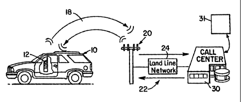
CA 02537388 2006-02-28
WO 2005/022084 PCT/IB2004/003143
[0056] The format of the DEST data is a design choice, depending in part on
the
format required for input into route calculation block 216 described below.
For example,
if the block 216 route calculation accepts street addresses, such as, for
example, "1367
Westview Street," then the DEST data could be only a verification indicator,
whereupon
the call center operator would enter the street address into the computing
resource 31
for route calculation.
[0057] A contemplated further feature of block 212 is that the operator, after
obtaining
the DEST data corresponding to the destination descriptor provided by the user
at block
210, will transmit a verifying query to the user. An example verifying query
is "I found
1367 Westview Street, it is about 15 miles north of you, in a residential
area. Does this
sound correct?" The user would respond with either a confirmation, such as
"Yes," or a
non-confirmation such as "That sounds too far to me, and I thought it was
south of
here." If the latter occurred, further queries could be used to correct, for
example, a
spelling error. To accommodate spelling issues, the method contemplates a
natural
language based search which locates a predetermined number of hits that
correspond
to the street address provided by the user. Truncated word and other search
methods
such as this are known in the general art of database queries.
[0058] Referring to FIG. 6, at function block 214 the call center operator
enters the
location data DEST, either the data obtained from the ROADMAP database or the
street
address as described above, into the computer resource 31. Then, at block 216,
the
computing resource 31 calculates the ROUTE data, which describes a route from
the
user's position POS(t) to the location represented by the DEST data. As
described
above in reference to FIG. 5, the route calculation is performed by, for
example, any of
the known route calculation methods known to persons skilled in the arts
pertaining to
road navigation systems. Typical methods assign fixed weights to road sections
or
segments, the weighting factors including, for example, speed limits, the
number of
traffic lights, average traffic load conditions, as well as variable
weightings such as
traffic conditions. The route calculation of step 216 then selects a route,
represented by
CA 02537388 2006-02-28
WO 2005/022084 PCT/IB2004/003143
ROUTE, having the lowest estimated time of travel from the user's present
location
POS(t) to the destination DEST.
[0059] Referring to FIGS. 1 and 6, block 216 preferably receives regularly
updated
POS(t) data from the user's vehicle 10, as shown by the arrow labeled "Updated
POS(t)
data". The local controller 44 carries out the regular updates. One reason for
sending
updated POS(t) data is that, depending on the speed and direction of the
vehicle 10,
and the processing time required for block 216, the user's vehicle may pass
intersections that change the calculations for the ROUTE data.
[0060] At the completion of block 216 the ROUTE data is ready for transmission
from
the call center 30 to the local controller 44 in user's vehicle. The ROUTE
data
preferably includes turn-by-turn instructions and, optionally, data for visual
display of the
route to the user. As described above the ROUTE data may further include data
describing landmarks and points of interest.
[0061] , Referring to FIGs. 1 and 6, the call center operator at block 218
transmits the
ROUTE data to the vehicle's local controller 44 by, for example, pressing a
button or
clicking on a screen icon on the video display (not labeled) of the computing
resource
31. The ROUTE data is then transmitted over, for example, the land line
connection 24
from the cell phone service provider, through the cell phone network 22 over
the last
wireless link 18 from the cell tower 20 closest to the user, to the user's
cell phone 12.
By sending the ROUTE data over the voice channel established by the cell phone
connection the need for expensive wireless connections such as, for example
GPRS or
3G, is eliminated. As the ROUTE data is received by the local controller 44 it
proceeds
to carry out the presentation of the ROUTE data to the user at block 120. It
will be
understood that blocks 218 and 220 may overlap, i.e., early-received ROUTE
data may
be presented to the user while further ROUTE data is being received.
[0062] A contemplated further feature of blocks 218 and 220 is for one or both
of the
local controller 44 and the call center computing resource 31 to monitor the
integrity of
the ROUTE data received by the local controller and/or the integrity of the
voice/data
channel established by the cell phone 12 between the controller 44 and the
computing
21
CA 02537388 2006-02-28
WO 2005/022084 PCT/IB2004/003143
resource 31. An example of such monitoring is to embed parity, or other error-
detection
code bits into the ROUTE data and program a parity or error correction
operation into
the local controller 44. Depending on design choice, the local controller 44
may be
programmed to send an error detection signal back to the call center upon
detecting an
error in, or interruption of, the ROUTE data. Alternatively, the local
controller 44 may
send a periodic signal verification data in the absence of detecting an error
in the
ROUTE data. Then, upon detecting an error, the call center and/or the local
controller
44 may initiate a resend. Error detection and resend schemes suitable for
these
purposes are well known in the communication arts and, therefore, further
detailed
description is not necessary.
[0063] As described above, the ROUTE data preferably includes turn-by-turn
instructions and, optionally, data for visual display of the route to the
user. This enables
the local controller 44 to quickly begin presenting audible instructions to
the user,
through the speaker 48, or a visible portion of a map, for display on the
video display
50, representing the ROUTE data. The driver can then start on the route
represented
by ROUTE while the remainder of the data is still being sent. This feature is
particularly
important if the voice channel of the cell phone 12, which typically has a
relatively small
bandwidth, is used for transmitting the ROUTE from the call center 30 to the
user at
block 218. A design consideration for this feature is that ROUTE data not be
so large
that it cannot be completely downloaded before the user gets to his or her
destination.
Further to this consideration is that each turn-by-turn instruction must be
presented to
the vehicle user before the turn arrives.
[0064] The local controller 44 preferably performs the following operations
and
functions during the information presentation block 220:
~ integration of the visual map information contained in the ROUTE into a\
contiguous map;
~ regular comparison of the updated POS(t) data from, for example, the
GPS receiver 42 with the positions represented by the ROUTE data. This
done for two reasons, one being to alert the driver if he or she is off-
22
CA 02537388 2006-02-28
WO 2005/022084 PCT/IB2004/003143
course, the other being to align the marker on the vehicle's visual display
representing the vehicle with the visual representation of the road. The
latter is typically required due to inaccuracies in the GPS data and
discrepancies between the actual physical location of roads and their
location as represented by the data in the ROADMAP database.
~ Timed presentations of the turn-by-turn directions to the user, either by
voice or other audio command through the speaker 48 or via the video
display 50, or both, by comparing the vehicle's POS(t) location with the
location of the next turn to be instructed by the turn-by-turn instructions. A
contemplated further feature of the block 220 instruction presentation is a
countdown timer, or distance indicator to show an upcoming turn.
~ Notification to the driver that the destination has been reached, which may
include a countdown timer or distance indicator.
[0065] Referring to FIGS. 1 and 3, the above-described methods are not limited
to
using cell phones for the wireless link 18 between the vehicle 10 and the call
center 30.
Other technologies may substitute for, or supplement, the cell phone
implementation.
One example is a satellite phone system, using either geostationary or low
earth
orbiting satellites such as, for example, Iridium. Advantages of satellite
phone systems
are coverage area and bandwidth.
(0066] Another is cellular data. In addition to using the voice channel of the
cell
phone, there are dedicated services that transmit data over the wireless
network.
These services include GPRS and 1XRTT. Navox technology is used to transmit
data
over the voice channel of the cellular network. Still another technology to
substitute for,
or supplement using the voice channel of standard cellular network telephone
links is
802.11. The 802.11 wireless standard is used widely in local area networks,
typically
for wireless connection of PCs to networks.
[0067] Advantages of the above described method include elimination of a map
database in the vehicle, with commensurate reduction in cost and increase in
reliability.
23
CA 02537388 2006-02-28
WO 2005/022084 PCT/IB2004/003143
A further benefit is the vehicle has continuous access to optimized routes
based on up-
to-date information in the ROADMAP database accessible by the call center 30.
[0001 j Those skilled in the arts pertaining to the above-described navigation
systems
and methods understand that the preferred embodiments described above may be
modified, without departing from the true scope and spirit of the description
and claims,
and that the particular embodiments shown in the drawings and described within
this
specification are for purposes of example and should not be construed to limit
the
claims below.
24