Note: Descriptions are shown in the official language in which they were submitted.
CA 02538469 2006-03-02
-1-
GEOGRAPHIC IMAGE STORAGE, TRANSMISSION AND DISPLAY SYSTEM
FIELD OF THE INVENTION
(0001] The present invention relates to an image storage, transmission and
display
system, and more particularly relates to a system in which a particular
geographic area is
identified by a user, and photographic images of that area are downloaded to
the user via an
input/output device.
BACKGROUND INFORMATION
[0002] Images of various geographic regions are available from sources such as
aircraft and satellite-mounted cameras. However, such images typically embody
a vast
amount of data that is difficult to transmit and display to users in a timely
fashion.
SUMMARY OF THE INVENTION
[0003] The present invention provides a system in which a geographic area of
interest
can be selected, and images of that area can be downloaded and displayed by a
user in an
efficient and timely manner. The area of interest may be selected using an
input device by
various means such as a map, longitudellatitude coordinates, a global
positioning system
(GPS}, and the like. Once the particular geographic area has been selected,
photographic
images corresponding to the selected area are downloaded to the user. The
images may
comprise visible photographs, IR photographs or other types of photographic
images that may
be stored in a suitable data storage system such as a server. In addition to
stored image data,
the photographic image data may also be generated real time and transmitted to
the user using
the present system. The images may be captured by any suitable digital or
analog device such
as an aircraft-mounted camera or a satellite-mounted camera.
[0004] In one embodiment, a relatively low resolution photographic image of a
large
geographic area is initially displayed to the user, and the user can then
select a limited region
of the image for closer viewing. The selected limited region of the image may
then be
downloaded to the user in a higher resolution format, thereby reducing the
amount of high
resolution data that must be transmitted to the user. Various display devices
may be used,
such as a personal data assistant (PDA), laptop computer, desktop computer,
vehicle-mounted
computer, tablet, cell phone and the like. In addition to displaying the
desired image, the
759228v3
CA 02538469 2006-03-02
-2-
display device may also be used as the input device to identify the geographic
area of interest,
e.g., by initially displaying a map of the region from which the specific area
of interest is
identified. In one embodiment, the photographic image may be overlaid over the
map
display.
[0005] An aspect of the present invention is to provide a system for
displaying
geographic images comprising an input device for selecting a geographic area
of interest, and
a display device for displaying photographic images corresponding to at least
a portion of the
selected geographic area, wherein the photographic images have different
resolutions.
[0006] Another aspect of the present invention is to provide a system for
storing,
transmitting and displaying geographic images comprising a photographic image
data storage
device, an input device communicating with the photographic image data storage
device for
selecting a geographic area of interest, and a display device communicating
with the
photographic image data storage device for displaying photographic images
corresponding to
at least a portion of the selected geographic area, wherein the photographic
images have
different resolutions.
[0007] A further aspect of the present invention is to provide a method of
displaying
geographic images comprising selecting a geographic area of interest, and
displaying
photographic images corresponding to at least a portion of the selected
geographic area,
wherein the photographic images have different resolutions.
[0008] These and other aspects of the present invention will be more apparent
from
the following description.
BRIEF DESCRIPTION OF THE DRAWINGS
[0009] Fig. 1 is a schematic diagram of a geographic image storage,
transmission and
display system in accordance with an embodiment of the present invention.
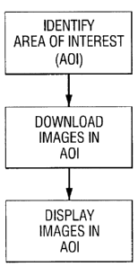
[0010] Fig. 2 is a flow diagram illustrating a method of identifying a
geographic area
of interest, downloading images corresponding to that area to a user, and
displaying the
images in accordance with a method of the present invention.
[0011] Fig. 3 is a partially schematic illustration of a map including
overlaid frames
corresponding to stored images taken from the region. The image data from part
or all of the
selected area may be downloaded and displayed in accordance with an embodiment
of the
presentinvention.
759228v3
CA 02538469 2006-03-02
-3-
[0012] Fig. 4 illustrates a relatively large geographic area within which a
smaller area
is selected from high-resolution image downloading and display in accordance
with an
embodiment of the present invention.
[0013] Figs. 5-7 illustrate a relatively low resolution image of a large
region that may '
be manipulated to select a smaller region within the area that may be
efficiently downloaded
and displayed at a significantly higher resolution in accordance with an
embodiment of the
present invention.
[0014] Fig. 8 is a schematic diagram illustrating details of a system in
accordance
with an embodiment of the present invention.
[0015] Fig. 9 is an image collection, catalog and logging flow chart
illustrating
operation of a system in accordance with an embodiment of the present
invention.
DETAILED DESCRIIyTION
[001b] Fig. 1 schematically illustrates a geographic image storage,
transnussion and
display system in accordance with an embodiment of the present invention.
Photographic
images are captured by an image sensor such as a digital or analog camera. The
photographic
images may be images taken in the visible region of the electromagnetic
spectrum, other
wavelengths such as infrared and the like. The image sensor may be mounted on
any suitable
platform which provides a desirable view of the geographic areas, such as
aircraft and
satellites.
[0017] As shown in Fig. 1, after the photographic images are captured by the
image
sensor(s), they may be transmitted to a server for storage and/or
transmission. The server
may be of any suitable configuration such as Microsoft Windows or Linux based
portable
computer (PC) systems. The image sensor communicates with the server by any
suitable
means such as standard commercial video interface (RS-170), video capture
card, parallel
data interface, network interface or the like. In one embodiment, the server
may store
multiple images of the same or similar geographic region taken at different
times. In many
instances, the most recent images are desired. However, in some cases it may
be desirable to
view earlier images of the particular geographic region.
[0018] In the embodiment shown in Fig. 1, the server communicates with both a
high
bandwidth user inputloutput device and a Iow bandwidth user input/output
device. Examples
of high bandwidth user input/output devices include personal data assistants,
laptop
759228v3
CA 02538469 2006-03-02
-4-
computers, desktop computers, vehicle-mounted computers, tablets, cell phones
and the like.
Examples of low bandwidth user input/output devices include personal data
assistants, laptop
computers, desktop computers, vehicle-mounted computers, tablets, cell phones
and the like.
[0019] The server communicates with the high bandwidth user input/output
device by
any suitable means such as a standard wired network interface, or a wireless
network
interface. The server communicates with the low bandwidth user inpudoutput
device by any
suitable means such as a standard synchronous or asynchronous serial interface
connected to a
UHF radio or dial-up phone connection. Although Fig. 1 illustrates an
embodiment in which
both high bandwidth and low bandwidth user input/output devices are used, it
is to be
understood that the present system may alternatively use only high bandwidth
or low
bandwidth user input/output devices.
[0020] Fig. 2 illustrates a method of identifying a geographic area of
interest,
downloading images corresponding to that area to a user, and displaying the
images in
accordance with an embodiment of the present invention. A geographic area of
interest may
be identified by various means such as a map, longitude/latitude coordinates,
a global
positioning system, photographs and the like. In one embodiment, a geographic
map or
photograph may be displayed on any suitable device such as a personal data
assistant (PDA),
laptop computer, desktop computer, vehicle-mounted computer, tablet, cell
phone or the like.
Alternatively, the user may identify longitude and latitude coordinates
corresponding to a
particular geographic area of interest. In another embodiment, a GPS system
may be used to
display a map of a geographic area in which a GPS transceiver is located. When
identifying a
geographic area of interest, it may be useful to adjust the scale of the
region, e.g., by zooming
in or zooming out of a map of the region. Furthermore, once a general
geographic area of
interest has been identified, it may be useful to adjust the viewed area,
e.g., by moving East,
West, North, South or combinations thereof on a display map of the area.
[002I] As shown in Fig. 2, once the geographic area of interest has been
identified,
images corresponding to that area may be downloaded. For example, photographic
image
data corresponding to the identified geographic area may be transmitted from a
server via
communication means to a high bandwidth and/or low bandwidth user output
device, such as
those described in connection with Fig. 1. In many cases, it is desirable to
download the most
recent images available for the geographic area of interest. However, it is
also possible to
select and download earlier images of the geographic area if desired. By
downloading
759228v3
CA 02538469 2006-03-02
-5-
geographic images obtained at different tunes, it is possible to display time-
sequenced images
such as movement of objects on the ground over a period of time.
[0022] The photographic images of the identified geographic area of interest
are then
displayed by means of any suitable display device such as a PDA, laptop
computer, desktop
computer, vehicle-mounted computer, tablet, cell phone or the like. In one
embodiment,
where a map is initially used to identify the geographic area of interest, the
photographic
images corresponding to the identified geographic area may be displayed
together on the same
display screen. For example, the photographic image may be displayed side by
side with the
map of the area, or the photographic image may be overlayed on the map of the
area.
[0023] Fig. 3 illustrates a map of a geographic region 10 including overlaid
frames 11
corresponding to individual photographic images taken of the region which are
then
combined together. If a selected geographic area 10 corresponds to more than
one of the
photographic images 11, those multiple images 11 may be combined together
before or at the
time the specific geographic area is selected for photographic viewing.
Multiple images may
be geograpically "stitched" together to create a single mosaic image of the
geographic area in
the requested area.
[0024] Fig. 4 illustrates a photographic image of a relatively large
geographic area 10
in which a smaller geographic area 12 is selected for detailed viewing in
accordance with an
embodiment of the present invention. In accordance with this embodiment, it is
possible to
download a low-resolution photographic image of the large region 10, followed
by
downloading a higher-resolution photographic image of the particular small
region 12 of
interest. In this manner, significantly less data must be transmitted because
only a limited
portion of the geographic area is downloaded in a high-resolution format. The
resolution of
the high-resolution image may be at least 10 times greater than the resolution
of the low-
resolution image, typically at least 100 or 1,000 times greater. For example,
a low-resolution
image may have a resolution down to 4 or 5 meters per pixel, while a high-
resolution image
may have a resolution of 1 or 2 meters per pixel, or less.
j002S] The high-resolution and low-resolution photographic images may
originate
from the same image sensor, or different image sensors. For example, a
relatively low
resolution digital camera may generate the low-resolution photographic image,
while a
relatively high-resolution digital camera may generate the high-resolution
photographic image
corresponding to the relatively small geographic area 12 selected.
Alternatively, a single
759228v3
CA 02538469 2006-03-02
-6-
digital camera may be used to collect high resolution images, and the
resolution of the large
geographic area 10 initially transmitted to the user may be electronically
reduced in resolution
in order to decrease the amount of data image that must be initially
transmitted to the user. In
this embodiment, after the user selects the smaller geographic area 12 for
detailed viewing,
the higher-resolution image data may then be transmitted to the user.
[0026] Figs. 5-7 illustrate a photographic image of a large region that may be
manipulated to select smaller regions within the area which may be efficiently
downloaded
and displayed at a significantly higher resolution in accordance with an
embodiment of the
present invention. In Fig. 5, the user requests photographic images via
Iongitude/latitude
coordinates or a map. A server then transmits a relatively low resolution
photographic image
of an area of interest. This low-resolution image may be downloaded and viewed
from the
server within a reasonable amount of time, e.g., less than 20 seconds. In Fig.
5, the full image
is 9.8 km x 9.8 km at 0.6 m resolution. The full image corresponding to the
entire
photographic image shown in Fig. 5 includes approximately 270 million image
pixels.
(0027] Based upon the PDA display shown in Fig. 5, the user may select a
smaller
geographic area for higher resolution photographic image display. Fig. 6
illustrates one such
higher resolution photographic image display, which may be transmitted to the
PDA within a
reasonable time, e.g., less than 20 seconds.
[0028] If an even higher resolution image of a smaller geographic area is
desired, the
user may select, download and display such a photographic image, as
illustrated in Fig. 7.
[0029] Table 1 summarizes the PDA display resolution (m/pixel), display
coverage,
transmission time, percentage of total pixels and cumulative percentage of
pixels for various
resolution layers, including those illustrated in Figs. 5-7.
Table 1
PDA ixels)
Dis
la
(320
x
240
DisplayDisplay Display Xmit Time% of CumulativeLayer
mipixelCoverage Coverage38.4 KbpsTotal %
(Km2 Pixels of Pixels
9.6 3.0 Km x 7.1 Km2 16 sec 0.03 0.03 Res 4
2.3 Km
4.8 1.5 Km x 1.7 Km2 16 sec 0.03 0.06 Res 3
1.1 Km
2.4 0.8 Km x 0.4 Km2 16 sec 0.03 0.09 Res 2
0.6 Km
1.2 0.4 Km x 0.1 Km2 16 sec 0.03 O.I2 Res 1
0.3 Km
0.6 0.2 Km x < 0.1 16 sec 0.03 0.15 Res 0
0.1 Km Km2
759228v3
CA 02538469 2006-03-02
[0030] As smaller and smaller geographic area photographic images are selected
and
displayed as shown in Figs. 5-7 and described in Table 1, extremely high
resolution imagery
is available to the user in a relatively short amount of time. For example, it
may take less
than one or two minutes to go from the low resolution, large geographic area
shown in Fig. 5
to the high resolution, small geographic area shown in Fig. 7. In doing so,
only about 0.15
percent of the original 270 million pixels are transmitted to the user.
[0031] Fig. 8 schematically illustrates an image collection, storage and
dissemination
system in accordance with an embodiment of the present invention. The system
includes
parallel and serial interfaces to one or more sensors, Input/output Processor
(IOP), storage
interface and storage devices (e.g., disk drives or solid state memory), an
Information Process
Server (IPS), a Narrow Band Link configuration (serial interface, radio and
antenna), and a
Wide Bank Link configuration (network interface, network switch, network
access point, RF
convertor hardware and antenna).
[0032] As shown in Fig. 8, the present system collects imagery over the
parallel
interface through the IOP, and catalogs the data received and stores the data
on the storage
device(s). Nan:ow Band or Wide Band user requests received are handled by the
IPS
processor, which acquires the raw data logged on the storage device(s),
creates the requested
image product, and returns the product back over the corresponding data link.
[0033] As shown in Fig. 8, the system contains a Narrow Band Link which
consists of
a military grade tactical radio and compatible antenna configuration. The IPS
processor
communicates to the tactial radio data rates between i6K-bits and ?8K-bits per
second.
[0034] Fig. 8 also illustrates the Wide Band Link which consists of a
connection from
the IPS to the link via an ethernet interface (100M-bit per second) to a
standard network
switch, which is then routed by a network Access Point. Output from the Access
Point is
then up-converted to radio frequency (RF) through RF hardware for output
through the
antenna. Conversly, RF data is received through the antenna, down-converted by
the RF
hardware, pushed to the Access Point and enters the AIA server via the network
interface
hardware.
[0035] Fig. 9 is a flow chart summarizing the multiple image collection and
storage,
cataloging, and data logging functions in accordance with the present
invention.
[0036] Whereas particular embodiments of this invention have been described
above
for purposes of illustration, it will be evident to those skilled in the art
that numerous
759228v3
CA 02538469 2006-03-02
_$_
variations of the details of the present invention may be made without
departing from the
invention as defined in the appended claims.
759228v3