Note: Descriptions are shown in the official language in which they were submitted.
CA 02538516 2006-03-03
, _1_
Title: GEOGRAPHICAL INDEXING SYSTEM AND METHOD
CROSS-REFERENCE TO RELATED APPLICATIONS
[0001] This application claims the benefit under 35 U.S.C. 119(e) of U.S.
Provisional Patent Application No. 60/657,926, filed March 3, 2005, the
contents
of which are incorporated by reference herein.
FIELD
[0002] The embodiments described herein relate to indexing systems and
methods and in particular to a geographical indexing system and method.
BACKGROUND
[0003] A search engine is a tool application used to search a database of
information against given criteria, and to return database entries that match
or
contain those criteria. In particular, Internet search engines search an
indexed
database of web pages, either submitted to the search engine or discovered
using crawlers. A crawler, or indexing robot, is an application used by the
search
engine to branch out across the Internet to collect web pages. When the
crawler
reaches a web page, it follows each of the links on that web page. The crawler
repeats this recursive process upon reaching each new web page. The web
pages it discovers are each indexed and entered into the search engine's
database. When a search is entered into the search engine, the query is run
against the indexed database, and a list of search results is returned.
[0004] The Internet contains billions of web pages, and is growing
exponentially. Hundreds or thousands of web pages are added to the Internet
each day. As a result, a comprehensive search engine database contains
billions
of web pages. Moreover, for any given query against the database, extremely
large numbers of results may be returned. For example, searching for the
string
'cat' using the search engine GoogIeT"" yields 141 million web pages,
CA 02538516 2006-03-03
. . _2_
representing a wide variety of information, including felines, CAT scans and
CaterpillarT"" industrial equipment.
[0005] Due to the overwhelming number of results for a query, not all
search results will be relevant to the interests of a particular user, and a
user will
generally not read the complete list of search results. Accordingly, the
search
engine attempts to present the most relevant search results first. To do this,
search engines rank results based on certain criteria for determining the
probability that a given result is relevant to the user. These criteria may
include
the age of the given result, the number of users who entered the same query
and
chose the given result from the list of search results, or the number of other
web
sites that refer to the given result.
[0006] Another criterion by which search results can be ranked is
geographical location. Ranking search results by geographical location is
known
as localized searching. A localized search allows the user to find results
near a
given geographical location (e.g. plumbers in Toronto). The geographical
location
may be selected by the search engine (e.g. the centre of Toronto or the
location
of town hall) or entered by the user (e.g. the user's home location). The goal
of a
localized search engine is to provide geographically relevant results with
optimal
user friendliness.
[0007] Major participants in the field of Internet search are devoting
resources to this end. Industry leaders convene at conferences around the
world,
such as the Kelsey Group Conference, to discuss advances in localized
searching, but problems of geographical relevance of results and user
friendliness of interface remain to be solved. To date, search engines are
reasonably successful at determining geographical relevance, but are not
optimally user friendly. A modern search engine may require a user to enter a
search string containing key words that are parsed according to rules in the
search engine parser (e.g. 'Plumber near 1 Yonge Street Toronto', where 'near'
is
a key word with special meaning to the search engine). This method allows the
user freedom to enter any search string, but for reasonable success the user
CA 02538516 2006-03-03
. ,
must be aware of the keywords of the parser. A search engine may instead
require the user to enter a search term and a location in separate designated
fields (e.g. 'Plumber' in a subject field and 'Toronto' or 'L6H 3J6' in a
location
field). This method allows the search engine to verify the location entered
against
a list of known locations. However, it is also restrictive to the user (e.g.
'The Big
Apple' may not be listed as a known location) and, depending on the number of
separate fields, can be tedious and time consuming to use.
[0008] If geographically relevant search results are determined and
presented to the user, the user may wish to communicate with the
organizations,
businesses or other entities described by the search results, especially where
the
search results represent goods or services. For example, if the user wishes to
purchase firewood from a local supplier, and searches for the term 'firewood'
in a
localized search engine, the user will receive a list of search results
containing
firewood suppliers located near their selected location. These search results
may
include contact information for each business represented in the results. If
the
user wishes to determine the provider of the cheapest or driest firewood, the
user
must contact each business individually. The user must also manage the large
number of responses they receive (e.g. ideally one response per business
contact). This is a tedious but currently common process for a user to
undertake.
[0009] None of these existing solutions provide an optimally user friendly
method of gathering location information from the user, which is critical to
guarantee relevant local results, or a mechanism for the user to communicate
directly and effectively with a group of organizations, businesses or other
entities
represented in the search results.
SUMMARY
[0010] The embodiments described herein provide in one aspect, a
geographical indexing system for use in association with a plurality of search
results, said geographical indexing system comprising:
CA 02538516 2006-03-03
(a) a memory for storing a user-selected location;
(b) a processor coupled to the memory for:
(i) obtaining the user-selected location by:
(I) providing a user with a graphical geographical map;
(II) receiving the user-selected location as selected by the
user on the graphical geographical map; and
(ii) indexing the plurality of search results based on the user-
selected location.
[0011] The embodiments described herein provide in another aspect, a
method for geographically indexing a plurality of search results, said method
comprising:
(a) obtaining a user-selected location by:
(i) providing a user with a graphical geographical map;
(ii) receiving the user-selected location as selected by the
user on the graphical geographical map; and
(b) indexing the plurality of search results based on the user-
selected location.
[0012] The embodiments described herein provide in another aspect, a
request for information system for use in association with a plurality of
search
results, said indexing system comprising:
(a) a memory for storing a user request for information;
(b) a processor coupled to the memory for:
(i) determining at least one targeted search result contact from the
plurality of search results;
(ii) receiving the user request for information;
(iii) sending the user request for information to the at least one
targeted search result contact; and
CA 02538516 2006-03-03
.
(iv) receiving at least one response from the at least one targeted
search result contact.
[0013] The embodiments described herein provide in another aspect, a
method for use in association with a plurality of search results, said method
comprising:
(a) determining at least one targeted search result contact from the
plurality of search results;
(b) receiving the user request for information;
(c) sending the user request for information to the at least one targeted
search result contact; and
(d) receiving at least one response from the at least one targeted search
result contact.
[0014] Further aspects and advantages of the embodiments described
herein will appear from the following description taken together with the
accompanying drawings.
BRIEF DESCRIPTION OF THE DRAWINGS
[0015] For a better understanding of the embodiments described herein
and to show more clearly how they may be carried into effect, reference will
now
be made, by way of example only, to the accompanying drawings which show at
least one exemplary embodiment, and in which:
[0016] FIG. 1 is a block diagram of an exemplary embodiment of a
geographical indexing system;
[0017] FIG. 2 is a flowchart illustrating the basic operational steps of the
geographical indexing system of FIG. 1;
[0018] FIG. 3A is a schematic diagram illustrating how the user-selected
map point is determined;
CA 02538516 2006-03-03
' -6-
[0019] FIG. 3B is a schematic diagram illustrating how the search results
are ranked by geographical location;
[0020] FIG. 3C is a schematic diagram illustrating how the search results
are displayed after the user has selected to send an e-mail user request for
information (RFI) to all or selected listings;
[0021] FIG. 3D is a schematic diagram illustrating how a direct or e-mail
user RFI is configured;
[0022] FIG. 3E is a schematic diagram illustrating how a direct or e-mail
user RFI is composed without using an existing template;
[0023] FIG. 3F is a schematic diagram illustrating how a direct or e-mail
user RFI is composed using a template;
[0024] FIG. 3G is a schematic diagram illustrating how an aggregated
information response is prepared;
[0025] FIGS. 4A and 4B are flowcharts illustrating the operation of the
indexing module of FIG.1;
[0026] FIG. 5 is a flowchart illustrating the operation of the searching
module of FIG.1;
[0027] FIG. 6 is a flowchart illustrating the operation of the location module
of FIG.1;
[0028] FIG. 7 is a flowchart illustrating the operation of the ranking module
of FIG.1;
[0029] FIG. 8 is a flowchart illustrating the operation of the collection
module of FIG.1;
[0030] FIG. 9 is a flowchart illustrating the operation of the listing module
of FIG. 1;
[0031] FIG. 10 is a flowchart illustrating the operation of the geographical
indexing system of FIG. 1 in response to receipt of a search request by e-
mail;
CA 02538516 2006-03-03
-7-
[0032] FIG. 11 is a flowchart illustrating the operation of geographical
indexing system of FIG. 1 in response to receipt of a request to send a user
RFI
by voice mail;
[0033] FIG. 12 is a flowchart illustrating the operation of geographical
indexing system of FIG. 1 in response to receipt of a request for driving
directions;
[0034] FIG. 13A is a schematic diagram illustrating a search entry from a
mobile device within geographical indexing system of FIG. 1;
[0035] FIG. 13B is a schematic diagram illustrating search results on a
mobile device within geographical indexing system of FIG. 1;
[0036] FIG. 13C is a schematic diagram illustrating how the user-selected
map point is determined on a mobile device by input string within geographical
indexing system of FIG. 1;
[0037] FIG. 13D is a schematic diagram illustrating how the user-selected
map point is determined on a mobile device by graphical geographical map
within geographical indexing system of FIG. 1;
[0038] FIG. 13E is a schematic diagram illustrating search results ranked
by geography on a mobile device within geographical indexing system of FIG. 1;
[0039] FIG. 13F is a schematic diagram illustrating how a search result
location is displayed on a graphical geographical map on a mobile device
within
geographical indexing system of FIG. 1;
[0040] FIG. 14A is a schematic diagram illustrating how a detailed view for
a search result is presented to the user within geographical indexing system
of
FIG. 1;
[0041] FIG. 14B is a schematic diagram illustrating how a start location for
driving directions is determined using a graphical geographical map within
geographical indexing system of FIG. 1;
CA 02538516 2006-03-03
[0042] FIG. 14C is a schematic diagram illustrating how driving directions
are presented to the user within geographical indexing system of FIG. 1;
[0043] FIG. 15A is a schematic diagram illustrating how a search zone is
defined by selecting points on a graphical geographical map within
geographical
indexing system of FIG. 1;
[0044] FIG. 15B is a schematic diagram illustrating how a search zone is
named within geographical indexing system of FIG. 1;
[0045] FIG. 15C is a schematic diagram illustrating how multiple search
zones are displayed and searched within geographical indexing system of FIG.
1;
[0046] FIG. 15D is a schematic diagram illustrating how search results are
displayed after a zone search within geographical indexing system of FIG. 1;
[0047] FIG 16A is a schematic diagram illustrating how geographical user
preferences are configured; and
[0048] Fig 16B is a schematic diagram illustrating how topical user
preferences are configured.
[0049] It will be appreciated that for simplicity and clarity of illustration,
elements shown in the figures have not necessary been drawn to scale. For
example, the dimensions of some of the elements may be exaggerated relative
to other elements for clarity. Further, where considered appropriate,
reference
numerals may be repeated among the figures to indicate corresponding or
analogous elements.
DETAILED DESCRIPTION
[0050] It will be appreciated that for simplicity and clarity of illustration,
where considered appropriate, reference numerals may be repeated among the
figures to indicate corresponding or analogous elements or steps. In addition,
numerous specific details are set forth in order to provide a thorough
understanding of the exemplary embodiments described herein. However, it will
CA 02538516 2006-03-03
be understood by those of ordinary skill in the art that the embodiments
described herein may be practiced without these specific details. In other
instances, well-known methods, procedures and components have not been
described in detail so as not to obscure the embodiments described herein.
Furthermore, this description is not to be considered as limiting the scope of
the
embodiments described herein in any way, but rather as merely describing the
implementation of the various embodiments described herein.
[0051] The invention may be implemented in hardware or software, or a
combination of both. However, preferably, the invention is implemented in
computer programs executing on programmable computers each comprising at
least one processor, a data storage system (including volatile and non-
volatile
memory and/or storage elements), at least one input device, and at least one
output device. Program code is applied to input data to perform the functions
described herein and generate output information. The output information is
applied to one or more output devices, in known fashion.
[0052] Each program is preferably implemented in a high level procedural
or object oriented programming language to communicate with a computer
system. However, the programs can be implemented in assembly or machine
language, if desired. In any case, the language may be a compiled or
interpreted
language. Each such computer program is preferably stored on a storage media
or device (e.g. ROM or magnetic diskette) readable by a general or special
purpose programmable computer, for configuring and operating the computer
when the storage media or device is read by the computer to perform the
procedures described herein. The inventive system may also be considered to be
implemented as a computer-readable storage medium, configured with a
computer program, where the storage medium so configured causes a computer
to operate in a specific and predefined manner to perform the functions
described herein.
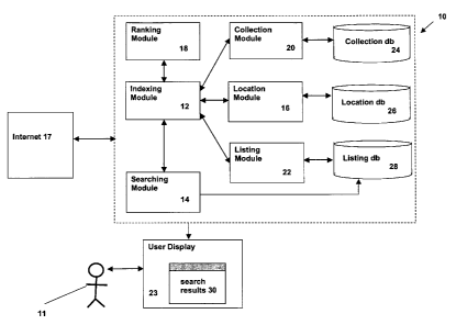
[0053] FIG. 1 is a block diagram of an exemplary embodiment of a
geographical indexing system 10. Geographical indexing system 10 includes an
CA 02538516 2006-03-03
' ' -10-
indexing module 12, a searching module 14, a location module 16, a ranking
module 18, a collection module 20, a listing module 22, a collection database
24,
a location database 26, and a listing database 28. As will be described in
detail,
geographical indexing system 10 utilizes a user-selected map point to rank
Internet or database search results by geographic proximity to the user 11.
Once
the search results are presented to the user 11 on user display 23,
geographical
indexing system 10 provides the user 11 with the ability to configure a user
request for information (RFI) to be sent to search result contacts of
interest.
Geographical indexing system 10 then collects and aggregates responses from
search result contacts of interest on administrative display 21 and forwards
them
to the user 11 in a user-friendly format.
[0054] The indexing module 12 coordinates all of the operations of the
searching module 14, the location module 16, the ranking module 18, the
collection module 20 and the listing module 22. Indexing module 12 utilizes
listing
module 22 to gather and index listings in the geographical indexing system and
searching module 14 to determine search results 30 to be presented to the user
11 on user display 23. Indexing module 12 also utilizes location module 16 to
gather a user-selected map point, and ranking module 18 to sort listing
database
28 search results 30 based on geographic proximity to the user-selected map
point gathered by location module 16. Indexing module 12 utilizes collection
module 20 to configure a user RFI to be sent to search result contacts of
interest.
[0055] The searching module 14 performs what is conventionally known
as database searching. Searching module 14 searches listing database 26
based on a search string gathered by location module 16 or stored in location
database 26. Search results 30 are returned to indexing module 12 for display
on
user display 23.
[0056] The location module 16 gathers geographical information in the
form of a user-selected map point (i.e. user's home location, user's work
location,
or alternative user location) from user 11 by presenting the user with a
graphical
CA 02538516 2006-03-03
, . -11-
geographical map. Location module 16 returns the user-selected map point to
indexing module 12.
[0057] The ranking module 18 is used to geographically rank the search
results 30 generated by searching module 14 according to location particulars
determined by the location module 16. Ranking module 18 returns the indexed
search results 30 to indexing module 12 for display to user 11 on user display
23.
[0058] The collection module 20 is used to determine a user RFI, store the
user RFI in the collection database 24 and then forward it through the
indexing
module 12 for dissemination to target search result contacts of interest.
Collection module 20 also gathers and manages responses from target search
result contacts of interest to the user 11, and stores them in collection
database
20.
[0059] The listing module 22 manages information regarding listings.
Listing module 22 retrieves information regarding listings (e.g. physical
address,
e-mail address) from listing database 28.
[0060] The collection database 24 contains information relating to existing
user RFIs that have been sent by the user 11 to targeted search result
contacts
of interest, as well as information relating to responses to user RFIs from
targeted search result contacts of interest to the user 11.
[0061] The location database 26 stores information relating to map points
previously selected by the user, specifically determining one of the following
locations: the user's work location, the user's home location, or an
alternative
user location. The information stored in location database 26 is used by
ranking
module 18 to sort search results 30.
[0062] The listing database 28 stores information regarding each listing,
including but not limited to contact information, advertisement information,
business information, and other information pertaining to a listing.
[0063] FIG. 2 is a flowchart which illustrates the basic operational steps
conducted by geographical indexing system 10.
CA 02538516 2006-03-03
' -12-
[0064] At step (202), indexing module 12 determines whether
geographical indexing system 10 has any stored topical or geographical
preferences (as configured in FIG. 16A and 16B) for the user 11. If not, then
at
step (204), indexing module 12 determines whether the user 11 has entered a
search string. If not, then indexing module 12 repeats this step.
[0065] If the user 11 has entered a search string, then at step (206),
searching module 14 conducts a search of listing database 28 according to the
search string provided by the user 11 and generates a set of search results
30.
[0066] At step (208), indexing module 12 provides a display of the non-
geographically indexed search results 30 generated by the searching module 14
on user display 23 to the user 11.
[0067] If geographical indexing system 10 has stored topical or
geographical preferences (as configured in FIG. 16A and 16B) for the user 11,
then at step (210), indexing module 12 determines whether the user 11 has
entered a search string. If not, indexing module 12 repeats this step.
[0068] If the user 11 has entered a search string, then at step (212),
searching module 14 conducts a search of listing database 28 according to the
search string provided by the user 11, and refines results based on topical or
geographical preferences stored for the user 11, and generates a set of search
results 30.
[0069] At step (214), indexing module 12 provides a display of the search
results 30, indexed by any relevant topical or geographical user preferences,
generated by the searching module 14 on user display 23 to the user 11.
[0070] At step (216), indexing module 12 determines whether the user 11
has requested to rank non-geographically indexed search results 30 by
proximity
to a geographical location. If not, then indexing module 12 returns to the
appropriate previous step of (208) or (214). If so, then at step (218),
indexing
module 12 utilizes location module 16 to obtain a user-selected map point.
CA 02538516 2006-03-03
' ' -13-
[0071] If there is a geographical location stored for the user-selected
location in location database 26, location module 16 retrieves the
geographical
location from location database 26 and returns the geographical location to
indexing module 12, which forwards the geographical location to ranking module
18. If there is no geographical location stored for the user-selected location
in
location database 26 for the user 11, then the user 11 submits a user-selected
map point as illustrated in FIG. 3A, where the user 11 is presented with a
graphical geographical map, and selects a point on the graphical geographical
map, and location module 16 stores this location in location database 26.
[0072] At step (220), ranking module 18 indexes the non-geographically
indexed search results 30 based on the user-selected map point and
corresponding geographical location and sends the indexed search results 30 to
indexing module 12 for display on user display 23 to the user 11, where the
indexed search results 30 appear as illustrated in FIG. 3B.
[0073] At step (222), indexing module 12 determines whether the user has
requested to start a new search. If so, the indexing module 12 returns to step
(202).
[0074] At step (224), the indexing module 12 determines whether the user
11 has requested to send a user RFI to targeted search result contacts. If so,
then at step (226), collection module 20 enables the user 11 to create and
configure a user RFI.
[0075] At step (228), indexing module 12 obtains target search result
contact information from listing database 28 utilizing listing module 22.
[0076] At step (230), collection module 20 collects and aggregates user
RFI responses from target search results and at step (232), the collection
module
provides the user 11 with the aggregated or individually received responses
from
target search result contacts to which the user 11 sent the user RFI.
[0077] While the components of the geographical indexing system 10
described herein are depicted as separate elements, it should be understood
that
CA 02538516 2006-03-03
' ' -14-
the indexing module 12, searching module 14, location module 16, ranking
module 18, collection module 20 and listing module 22 may all be combined in
different combinations, forming different modules providing the same function,
as
would be recognized by those skilled in the art. It should also be understood
that
the collection database 24, location database 26, and listing database 28 may
reside on separate computer systems (e.g. on a PC or a server computer) or on
the same computer system, and may be connected to each other and to the
geographical indexing system 10 directly or indirectly (e.g. across a local
network
or the Internet). Alternatively, HTTP Magic CookiesT"" could be used to store
information or preferences instead of a centralized database.
[0078] It should be understood that the exemplary embodiments of the
geographical indexing system 10 discussed within this disclosure are for
illustrative purpose only and many variations on the specific implementations
being discussed are possible. For example, while the geographical indexing
system 10 described herein is discussed in relation to searching directory
listings, it should be understood that the geographical indexing system 10
could
be applied to any database system, as would be recognized by those skilled in
the art.
[0079] FIG. 3A is a schematic diagram illustrating how the user-selected
map point is determined by presenting the user with a graphical geographical
map on which to select a map point. While the method of collecting user
location
information is illustrated as one component of an exemplary embodiment of
geographical indexing system 10, it should be understood that this method
could
be implemented independent of geographical indexing system 10.
[0080] FIG. 3B is a schematic diagram illustrating how the search results
are ranked by proximity to the user-selected map point selected in FIG. 3A.
Beside each search result is displayed the distance and/or direction from the
user-selected location to the physical location of the search result as a
hyperlink
or, if no physical location exists for a search result, a message to that
effect (e.g.
30 "Distance data not available"). If the hyperlink is displayed, and the user
clicks on
CA 02538516 2006-03-03
' ' -15-
the hyperlink, then the user is presented with a graphical geographical map
indicating the user-selected location and the location of the search result.
[0081] FIG. 3C is a schematic diagram illustrating how the search results
are displayed after the user has selected to send a user RFI. The search
results
are listed with selection buttons next to each, using which the user
designates
the target search result contacts of interest for the RFI. In another
embodiment,
selection buttons always appear next to search results, without the need for
the
user to specify their intent to send a user RFI.
[0082] FIG. 3D is a schematic diagram illustrating how a user RFI is
configured. The user selects whether to have individual responses forwarded to
the user as they are received, or to receive aggregated responses sent at
regular
intervals. If aggregated responses are chosen, the user selects how frequently
to receive aggregated responses to their user RFI (e.g. daily, weekly,
monthly, or
as the responses are received). If the user chooses a frequency that is an
interval (e.g. weekly), then user RFI responses are saved until the expiry of
the
interval, and aggregated into a single message sent by e-mail to the user, in
the
format illustrated in FIG. 3G. The user also selects whether to remain
anonymous or to include their personal e-mail address in the user RFI. If the
user
chooses to remain anonymous, a temporary e-mail address (e.g.
tempt @redCity.com) is created, and target contacts of interest respond to the
temporary address.
[0083] The user also chooses a period of time after which their temporary
e-mail address will expire. If the user chooses to include their personal e-
mail
address in the user RFI, then responses from target contacts of interest are
sent
to the user's personal e-mail address. In either case, all responses to user
RFIs
are saved in collection database 24. The user further selects whether to
compose their own user RFI, as illustrated in FIG. 3E, or to create their user
RFI
from one of several existing templates, as illustrated in FIG. 3F. In either
case,
the user submits the content of their RFI and collection module 20 sends the
RFI
to indexing module 12 for distribution to the target contacts of interest.
CA 02538516 2006-03-03
-16-
[0084] FIGS. 4A and 4B are flowcharts illustrating the operation of
indexing module 12 of FIG.1. Indexing module 12 accepts either a request to
perform a regular search, or a request to perform a zone search.
[0085] A regular search comprises a search string containing terms
defining search results 30 the user 11 wishes to find (e.g. "plumber in
Toronto").
In one embodiment, this search string may include a term or terms describing a
neighborhood (e.g. "Bloor-West Village"), such that geographical indexing
system 10 presents only search results 30 in that neighborhood.
[0086] A zone search is a search for results whose geographic location is
within a user-specified area. The user 11 specifies this area by selecting
three or
more points on a graphical geographical map, enclosing a geometric shape, as
illustrated in FIG. 15 A. A zone search only returns search results whose
address, resolved to a geocode, is within one or more of the selected search
zones. Search zones may be saved or used only once.
[0087] The user 11 may choose to refine any query or search results 30 to
show only results located within at least one user-defined search zone. If the
user 11 has previously stored search zones they may choose to use one of those
stored search zones, or to create a new search zone. If the user 11 chooses a
stored search zone by which to refine their search results, a new set of
indexed
search results will be shown, now including only those results whose address,
resolved to geocode, is within one or more of the at least one user-selected
search zones.
[0088] At step (402), indexing module 12 determines whether it has
received a request to perform a regular search. If so, then indexing module 12
invokes step (416).
[0089] Alternatively, if indexing module 12 has received a request to
perform a zone search, as determined at step (404), then at step (405),
indexing
module 12 determines whether the user 11 wishes to use a saved search zone. If
so, then at step (407), indexing module 12 determines whether a stored search
CA 02538516 2006-03-03
-17-
zone exists for the user 11. If so, the user 11 selects a stored search zone,
as in
step (409).
[0090] If the user 11 does not wish to use a stored search zone, or if the
user 11 has no stored search zones, then at step (406), indexing module12
displays a graphical geographical map to the user 11. The user 11 selects any
number of points on the map, as described by step (408) and illustrated in
FIG.
15A, forming any shape, and closing the shape by selecting the initial point
again
on the map. The user 11 is then prompted to save and name the newly formed
zone, to define another zone, or to perform a search of the zones they have
just
created, as illustrated in FIG. 15B. Multiple search zones are displayed as
illustrated in FIG. 15C.
[0091] At step (410), indexing module 12 determines whether the user has
selected to save the search zone. If so, indexing module 12 saves the search
zone to locations database 26.
[0092] In either case, at step (414), indexing module 12 accepts a search
query from the user for the selected zone or all zones, as illustrated in FIG.
15C,
and invokes step (416). At step (416), indexing module 12 sends a search
request to searching module 14, which searches listings database 28 according
to the search query and returns search results 30.
[0093] At step (418), indexing module 12 determines whether it has
received search results 30 from searching module 14. If so, then at step
(420),
indexing module 12 displays search results 30 on user display 23, as
illustrated
in FIG. 15D, indicating in which zone each search result was located.
[0094] At this stage, the user 11 may request to geographically rank the
search results, or to send a user RFI to search result contacts of interest.
These
functions may be performed in any order, any number of times.
[0095] At step (422) indexing module 12 determines whether the user 11
has requested to send a user RFI to search result contacts of interest. If so,
then
at step (424), indexing module 12 sends a request to send a user RFI to
CA 02538516 2006-03-03
. ' -18-
collection module 20, which allows the user to create and configure a user RFI
and select search result contacts of interest who will receive the RFI, and
waits
for a response.
[0096] At step (426), indexing module 12 determines whether it has
received a user-prepared RFI to be distributed to search result contacts of
interest. If so, then at step (428), indexing module 12 sends a request for
listing
addresses to listing module 22, which searches listing database 28 for contact
information (e.g. e-mail address) for contacts of interest, and waits for a
response.
[0097] At step (430), indexing module 12 determines whether it has
received the destination addresses of the search result contacts of interest
for
the user RFI. If so, then at step (432), indexing module 12 sends the RFI to
the
contacts of interest, and at step (434), indexing module 12 notifies the user
11 on
user display 23 that the RFI has been sent to the requested search result
contacts of interest, and at step (436), indexing module 12 displays the
search
results 30 as in step (420).
[0098] At this point, the user 11 may request to rank the results based on
a geographical location, request to send another user RFI to search result
contacts of interest, or begin a new search.
[0099] At step (438), indexing module 12 determines whether the user 11
has requested to geographically rank search results 30. If so, then at step
(440),
indexing module 12 sends a request for a user-selected location to location
module 16 and waits for a response.
[00100] At step (442), indexing module 12 determines whether it has
received a user-selected location from location module 12. If so, then at step
(444), indexing module 12 sends a geographical ranking request to ranking
module 18 and waits for a response.
[00101] At step (446), indexing module 12 determines whether it has
received geographically ranked results from ranking module 18. If so, then at
CA 02538516 2006-03-03
- 19 -
step (448), indexing module 12 displays the geographically ranked search
results
30 on user display 23, as illustrated in FIG. 3B.
[00102] At this point, the user 11 may request to rank the search results
based on a different geographical location, to send a user RFI to search
result
contacts of interest, or to begin a new search.
[00103] While the method of sending a user RFI is illustrated as one
component of an exemplary embodiment of geographical indexing system 10, it
should be understood that this method could be implemented independent of
geographical indexing system 10.
[00104] FIG. 5 is a flowchart illustrating the operation of searching module
14 of FIG.1. At step (502), searching module 14 determines whether it has
received a search request from indexing module 12. If so, then at step (504),
searching module 14 searches listing database 28 according to the user query.
[00105] At step (506), searching module 14 determines whether the search
of listing database 28 yielded any search results 30. If so, then at step
(508),
searching module 14 returns those search results 30 to indexing module 12. If
not, then at step (510) searching module 14 returns an error to indexing
module
12 expressing the fact that there were no search results 30 found in listing
database 28 matching the query.
[00106] FIG. 6 is a flowchart illustrating the operation of location module 16
of FIG.1. At step (602), location module 16 determines whether it has received
a
request for a user-selected location from indexing module 12. If so, then at
step
(604) location module 16 searches location database 26 for a saved map point
corresponding to the user-selected location requested by the user 11, if one
exists.
[00107] If a map point exists for the user 11 in location database 26, as
determined at step (606), then at step (614), location module 16 returns the
user-
selected location from location database 26 to indexing module 12.
CA 02538516 2006-03-03
' -20-
[00108] If no map point exists for the user 11 in location database 26, then
at step (608), location module 16 displays a graphical geographical map on
user
display 23, upon which the user 11 selects a map point, as illustrated in FIG.
3A.
Once the user selects a map point, as determined in step (610), then at step
(612), location module 16 stores the user-selected location in location
database
26, and at step (614) returns the user-selected location to indexing module
12.
[00109] FIG. 7 is a flowchart illustrating the operation of ranking module 18
of FIG.1. At step (702), ranking module 18 determines whether it has received
a
geographical ranking request from indexing module 12. If so, then at step
(704),
ranking module 18 determines the distance from the user-selected location
determined by location module 16 of each of the search results 30 found by
searching module 14.
[00110] At step (706) ranking module sorts the results according to their
distance from the user-selected location.
[00111] At step (708), ranking module 18 returns the sorted results to
indexing module 12 for display to the user 11 on user display 23.
[00112] FIG. 8 is a flowchart illustrating the operation of collection module
of FIG. 1. A user 11 may send an e-mail user RFI through two different
channels: regular (sent to target search results) and direct (sent to a target
20 category). A regular e-mail user RFI is created by performing a search, and
selecting target contacts of interest from the search results, as illustrated
in FIG.
3C. A direct e-mail user RFI is created by selecting a target category (e.g.
plumbers@redCity.com) from a list of predefined categories (not shown).
[00113] While these methods of sending a user RFI are illustrated as
components of an exemplary embodiment of geographical indexing system 10, it
should be understood that these method could be implemented independent of
geographical indexing system 10.
(00114] At step (802), collection module 20 determines whether it has
received a request to send a user RFI from indexing module 12. If so, then at
CA 02538516 2006-03-03
-21 -
step (804), the user 11 selects target search result contacts of interest for
the
user RFI, as illustrated in FIG. 3C. Alternatively, at step (806), if
collection
module 20 receives a request from the user 11 to send a direct RFI, then at
step
(808), collection module 20 displays a predefined list of target categories,
from
which the user 11 may choose to refine a list of target contacts of interest
by
geographical sorting or zone searching (not shown).
[00115] In either case, at step (812), collection module 20 allows the user
11 to create and configure a user RFI, including message contents and target
search result contacts of interest, as illustrated in FIGS. 3C, 3D, 3E, 3F and
3G.
[00116] At step (814), collection module 20 returns this RFI to indexing
module 12 for distribution to the specified contacts of interest.
[00117] At this point, collection module 20 may either receive a response to
a user RFI from a target search result contact of interest, or the designated
time
period to collect responses can elapse.
[00118] If collection module 20 receives a response to a user RFI, as
determined in step (816), then at step (818), collection module 20 stores the
response in collection database 24. Additionally, at step (820), collection
module
determines whether the user 11 chose to receive RFI responses as they are
received by collection module 20. If so, then at step (822), collection module
20
20 forwards the user RFI response to the user 11 and returns to step (814),
and
may either receive more RFI responses or wait for the next time period to
elapse.
[00119] At step (824), collection module 20 determines whether the user
chose to receive aggregated responses. If so, then at step (826), collection
module 20 determines whether the designated time period for collecting
responses has elapsed (e.g. one day, one week), as configured in FIG. 3D,
collection module 20 retrieves the responses collected to date, if any, from
collection database 24, and aggregates the retrieved responses, if any, into a
single message, as illustrated in FIG. 3G. as designated at step (828).
CA 02538516 2006-03-03
-22-
[00120] At step (830), collection module 20 sends this single message to
indexing module 12 for distribution to the user 11. At this point collection
module
20 returns to step (814), and may either receive more RFI responses or wait
for
the next time period to elapse.
[00121] FIG. 9 is a flowchart illustrating the operation of listing module 22
of
FIG. 1. Listing module 22 retrieves listing information (e.g. address) from
listing
database 28.
[00122] At step (902), listing module 22 determines whether it has received
a request from indexing module 12 to retrieve a listing address from listing
database 28. If so, then at step (904), listing module 22 retrieves the
listing
address from the listing database 28 and at step (906), listing module 22
returns
the listing address to indexing module 12.
[00123] FIG. 10 is a flowchart illustrating the operation of geographical
indexing system 10 of FIG. 1 in response to receipt of a search request by e-
mail. In one embodiment, the user 11 submits a query by e-mail to a specific
address (e.g. "search@redCity.com"), where the subject line (e.g. "fire wood")
is
the query. In another embodiment, the user submits a query by sending a blank
e-mail where the e-mail address contains the query (e.g.
firewood@redCity.com).
[00124] While the method of searching by e-mail is illustrated as one
component of an exemplary embodiment of geographical indexing system 10, it
should be understood that this method could be implemented independent of
geographical indexing system 10.
[00125] At step (1002), geographical indexing system 10 determines
whether it has received a search request from the user 11 by e-mail. If so,
then at
step (1004), geographical indexing system 10 sends a search request to
searching module 14 and waits for a response.
[00126] At step (1006), geographical indexing system 10 determines
whether it has received search results from searching module 14. If so,
CA 02538516 2006-03-03
-23-
geographical indexing system 10 sends an e-mail to the user 11 containing the
search results 30 in a format corresponding to the format of the initial e-
mail
search request (e.g. if the query e-mail was written in HTML, then the search
results will be sent in HTML), with a subject line notifying the user of the
contents
of the e-mail. Additionally, if the query was a direct match with a category
(in
which case a predetermined set of category results is returned to the user)
then
the user is presented with the option to send an RFI to the search results 30,
in
the form of a hyperlink to the direct RFI function described in FIG. 8.
[00127] At step (1010), geographical indexing system 10 determines
whether it has received a request from the user 11 to send a direct RFI. If
so,
then at step (1012), geographical indexing system 10 sends a request to send a
direct RFI to collection module 20.
[00128] While the method of sending a direct user RFI is illustrated as one
component of an exemplary embodiment of geographical indexing system 10, it
should be understood that this method could be implemented independently of
geographical indexing system 10.
[00129] FIG. 11 is a flowchart illustrating the operation of geographical
indexing system 10 of FIG. 1 in response to receipt of a request to send an
RFI
by voice mail. In one embodiment, the user 11 places a telephone call to a
phone
number assigned to a category. Once the user 11 is connected to the
geographical indexing system 10, the user 11 hears a pre-recorded message
prompting them to configure their voice mail RFI.
[00130] While the method of sending a voicemail user RFI is illustrated as
one component of an exemplary embodiment of geographical indexing system
10, it should be understood that this method could be implemented
independently of geographical indexing system 10.
[00131] At step (1104), the user 11 configures and creates a vocal RFI
message for all contacts in the selected category, which may include
instructions
to contact the user 11 directly, through a temporary voice mail box, or
through e-
mail to a temporary e-mail account.
CA 02538516 2006-03-03
' ' -24-
[00132] At step (1106), the user 11 is provided with the account information
for the temporary account at which the user will retrieve their responses, if
they
requested a temporary voice mail box or e-mail account.
[00133] At step (1108), geographical indexing system 10 forwards the voice
mail RFI to target contacts in the selected category.
[00134] FIG. 12 is a flowchart illustrating the operation of geographical
indexing system 10 of FIG. 1 in response to receipt of a request for driving
directions. Driving directions determine a path, preferably the optimal path,
between a start location (e.g. the user's home location) and an end location
(e.g.
a listing's physical location). In one embodiment, start and end locations can
be
reversed, providing directions from an end location to a start location.
[00135] While the method of obtaining driving directions is illustrated as one
component of an exemplary embodiment of geographical indexing system 10, it
should be understood that this method could be implemented independently of
geographical indexing system 10.
[00136] Each listing in listing database 28 has a detailed view associated
with it, as illustrated in FIG. 14A. For any listing with a physical address,
the
detailed view includes the option to obtain driving directions to the physical
address of the listing.
[00137] At step (1202), geographical indexing system 10 determines
whether it has received a request for driving directions to a listing. If so,
then at
step (1204), geographical indexing system 10 sends a request for a user-
selected location to location module 16, which start location information from
the
user 11 as illustrated in FIG. 14B, and waits for a response.
[00138] At step (1206), geographical indexing system 10 determines
whether it has received a user-selected location from location module 16. If
so,
then at step (1208), geographical indexing system 10 computes driving
directions
from the user-selected location to the listing's physical location, and at
step
CA 02538516 2006-03-03
-25-
(1210), geographical indexing system 10 displays the driving directions to the
user 11 on user display 23, as part of the detailed view illustrated in FIG.
14C.
[00139] In another embodiment, the user may also enter the user-selected
location as an address. In yet another embodiment, the user may enter the user-
selected location as a street intersection, or select a street intersection
from a
list. In yet another embodiment, the user may enter the user-selected location
as
the name of a landmark, or choose the name of a landmark from a list.
[00140] It will be appreciated that any of the features of the embodiment
described herein may be accessed by any computing device, and displayed on
any user display 23, including wired or wireless mobile devices, with or
without
WAP or GPS technology. FIG. 13A illustrates a search from a mobile device with
a graphical display, while FIG. 13B illustrates the display of the
corresponding
search results 30. Where the mobile device display is contains touch sensors
or
a mouse device, a map point may be collected from the user using a graphical
geographical map as illustrated in FIG. 13D.
[00141] Otherwise, a map point may be gathered using textual input, as
illustrated in FIG. 13C, or determined automatically by the device using GPS
or
another technology (e.g. the user 11 may choose to sort search results 30 by
distance from the device). Search results 30 are ranked and presented on the
mobile device display as illustrated in FIG. 13E. Any of the search results 30
with
physical addresses may be shown on a graphical geographical map as illustrated
in FIG. 3F.
[00142] Alternatively, geographical indexing system 10 may be accessed by
GPS-enabled devices or publicly located Internet kiosks or other devices.
These
devices may offer additional capability of sorting results by distance from
the
device, where the device sends its location to the geographical indexing
system
with each query and without intervention from the user 11. Such a device may
automatically or may, with one click performed by the user, sort results by
proximity to the device. These devices may also provide the capability to
obtain
driving directions from their current location, by sending their location with
the
CA 02538516 2006-03-03
-26-
user query to geographical indexing system 10. While these features are a
selection of possible functionality accessible to mobile devices, any mobile
device may in theory access any feature of geographical indexing system 10.
[00143] FIG. 14A is a schematic diagram illustrating how a detailed view for
a search result is presented to a user. The detailed view includes all
available
data from listing database 28 associated with a specific listing. Details may
include physical address, website address, e-mail address, company
description,
phone number, and a map. For any listing with a physical address, driving
directions may be obtained using a start point previously stored in location
database 26, or by selecting a start point on a graphical geographical map, as
illustrated in FIG. 14B, or by entering a street address, street intersection,
as
illustrated in FIG. 4A, or a landmark location, or a current GPS location, as
other
examples. Driving directions are determined by geographical indexing system 10
and displayed in the detailed view, as illustrated in FIG. 14C.
[00144] FIG. 15A is a schematic diagram illustrating how a search zone is
defined by selecting points on a graphical geographical map within
geographical
indexing system of FIG. 1;
[00145] FIG. 15B is a schematic diagram illustrating how a search zone is
named within geographical indexing system 10.
[00146] FIG. 15C is a schematic diagram illustrating how multiple search
zones are displayed and searched within geographical indexing system 10.
[00147] FIG. 15D is a schematic diagram illustrating how search results are
displayed after a zone search within geographical indexing system 10.
[00148] While the method of searching or refining search results by
designating a zone is illustrated as one component of an exemplary embodiment
of geographical indexing system 10, it should be understood that this method
could be implemented independent of geographical indexing system 10.
[00149] FIG. 16A is a schematic diagram illustrating how geographical user
preferences are configured. Stored geographical preferences may include to
CA 02538516 2006-03-03
-27-
show only results within selected search zones or neighborhoods, results
within a
certain distance from a map point, address, intersection or other location, or
results that have been viewed before, for example. Stored geographical
preferences may also include to sort results by distance from a map point,
intersection, address, landmark or other location, for example. The user 11
may
select to store these preferences for use in all future searches, or just for
a
current session. Additionally, any of these preferences may be set for only
the
current search by allowing the user 11 to select the preference at the time of
submitting a search to searching module 14.
[00150] While the method of storing geographical preferences is illustrated
as one component of an exemplary embodiment of geographical indexing system
10, it should be understood that this method could be implemented independent
of geographical indexing system 10.
[00151] FIG. 16B is a schematic diagram illustrating how topical user
preferences are configured. Stored topical preferences may include to search
only environmentally friendly, ethical, advertiser, event or government
listings, or
listings within a certain class (e.g. businesses that are currently open), for
example. Stored topical preferences may also include to search only listings
with
websites, e-mail addresses, complete addresses or phone numbers, for
example. Stored topical preferences may also exclude certain categories or
listing types from searches. The user 11 may select to store these preferences
for use in all future searches, or just for a current session. Additionally,
any of
these preferences may be set for only the current search by allowing the user
11
to select the preference at the time of submitting a search to searching
module
14.
[00152] While the method of storing topical preferences is illustrated as one
component of an exemplary embodiment of geographical indexing system 10, it
should be understood that this method could be implemented independent of
geographical indexing system 10.
CA 02538516 2006-03-03
-28-
[00153] It will be appreciated that the methods of storing topical and
geographical preferences described herein may have uses other than for
localized searching. For example, topical or geographical preferences of users
can be correlated to form topical or geographical groups, accordingly. Based
on
their preferences, different users may see different search results 30 or
interface
options.
[00154] Moreover, advertisers in a directory may pay to be displayed at a
certain place in the search results list for specific topical or geographical
groups
(e.g. a dental practitioner in downtown Toronto may pay to be listed as the
first
search result for users browsing the category 'Dentists', and/or for users
whose
user-selected map point, map search zone, or other geographical preference
area is in downtown Toronto, and/or only for users 11 whose search was
specifically for dentists in downtown Toronto). The advertiser can choose
target
topical or geographical preference groups, and/or target current device
locations
(e.g. the originating location of a search), optionally through an interface.
[00155] In conventional search engines, the component or components
performing the equivalent function to the location module 16 require the user
11
to follow a series of steps in which the user 11 provides various details
about
their desired geographical location (e.g, city, address, postal code). In this
exemplary embodiment, the user 11 is presented with a graphical geographical
map and, in one step, submits all required information about their location as
a
geographical map point.
[00156] The method of gathering geographical information described in this
exemplary embodiment is a significant improvement over existing methods
because it is faster and simpler than entering location information into
multiple
fields, and does not require the user to know the street address or postal
code of
the user-selected location. therefore achieves superior user friendliness
compared to existing methods. It will be appreciated that the method described
herein for gathering user location by graphical geographical map may have
alternative uses related to localized searching.
CA 02538516 2006-03-03
-29-
[00157] Conventional search engines may provide contact information for
search results. However, none contain a mechanism for sending the same
communication to multiple target search result contacts of interest, as in the
case
for obtaining information about a product or obtaining a price quote on a
product
provided by a business. The exemplary embodiment described herein discloses
a system for the user 11 to create user RFIs and send them to contacts of
interest. This exemplary embodiment also describes a system for collecting
responses from target contacts of interest to whom the user 11 sent a user
RFI,
merging those responses, and sending them to the user on predefined intervals
(e.g. daily, weekly). In this regard this exemplary embodiment represents a
distinct improvement over existing search engines and directories.
[00158] The exemplary embodiments described herein significantly
overcome the obstacle of user-friendliness. In particular, the exemplary
embodiments described herein disclose a method of gathering geographical
location information from the user using a graphical geographical map, on
which
the user selects their location.
(00159] The exemplary embodiments described herein also significantly
overcome the obstacle of communication between users and businesses
represented in local search results. In particular, the exemplary embodiments
described herein disclose a method for the user to send e-mail messages or
other messages to contacts of interest, determined from search results
provided
by the localized search engine. The exemplary embodiments described herein
also disclose a method of collecting responses from contacts of interest and
communicating those responses to the user.
[00160] It will be appreciated that while the present invention has been
described in the context of various methods including a geographical indexing
method, the system, processes and methods of the present invention are
capable of being distributed in a computer program product comprising a
computer readable medium that bears computer usable instructions for one or
more processors. The medium may be provided in various forms, including one
CA 02538516 2006-03-03
-30-
or more diskettes, compact disks, tapes, chips, wireline transmissions,
satellite
transmissions, Internet transmission or downloadings, magnetic and electronic
storage media, digital and analog signals, and the like. The computer useable
instructions may also be in various forms, including compiled and non-compiled
code.
[00161] While certain features of the invention have been illustrated and
described herein, many modifications, substitutions, changes, and equivalents
will now occur to those of ordinary skill in the art. It is, therefore, to be
understood
that the appended claims are intended to cover all such modifications and
changes as fall within the true spirit of the invention.