Note: Descriptions are shown in the official language in which they were submitted.
CA 02540693 2014-08-22
61181-160
SYSTEMS AND APPLICATIONS OF LIGHTER-THAN-AIR (LTA)
PLATFORMS
TECHNICAL FIELD OF THE INVENTION
The present invention relates to unmanned lighter-than-air platforms operating
in the
stratosphere and more particularly, their termination and recovery.
BACKGROUND OF THE INVENTION
Unmanned lighter-than-air ballooncraft have been used for many years to
perform tasks
such as near space research, and meteorological measurements. Such
ballooncraft have even
carried payloads with instrumentation that sometimes includes radio
transmission capabilities.
Until recently, all communications satellites were located on one orbit called
the
geosynchronous arc, which is located 22,300 miles above the Earth's equator.
Since
international treaties required satellites to be spaced two degrees apart,
there were only 180 sites
on geosynchronous orbit. An optimally-designed three-stage chemical rocket
typically must be
94% propellant at launch to reach geosynchronous orbit, which, after
allocating about 5.6% of
the weight for the rocket, only leaves about 0.49 of the initial launch weight
for the satellite. To
put this in perspective, a typical 3,000 lb. automobile with the same
performance would only be
able to carry one 200 lb. person, would need an 8,400-gallon fuel tank, and
would be junked after
one trip! Finally, although the NASA space shuttle can service a few very low
orbit satellites at
great expense, most satellites cannot be serviced or upgraded after being
launched.
Currently, since there are a limited number of sites on the geosynchronous
orbit,
geosynchronous satellites are growing in size and performance, now being able
to broadcast
=
1
CA 02540693 2006-03-29
WO 2005/032936 PCT/US2004/032206
television signals directly to homes. Recently, additional satellite networks
have been deployed
that do not require a geosynchronous orbit. All of these new networks have
launched smaller
communication satellites into much lower orbits where there are an unlimited
number of sites.
Because the satellites required for a network are more numerous and because
the satellites are
smaller, up to 8 satellites per rocket have been launched. Although satellites
have become
smaller and more numerous, there are still no "personal satellites" and no
mass producers of
consumer products in the satellite industry today. It might be estimated that
a network of
microsatellites in low Earth orbit and ground equipment to accommodate the
tracking,
transmission, reception, signal handoff among the plurality of microsatellites
and necessary
system network for a voice system would cost at least $3 billion to deploy.
Within four years of
deploying a system, each one of five million subscribers might be expected to
invest as much as
$3,000 in the equipment, which results in a total combined investment by the
users in the new
equipment of about $15 billion. The cost of deploying a smaller system of low
Earth orbit
advanced messaging satellites might be estimated at about $475 million. Such a
system might be
expected to serve two to three million subscribers, each with user equipment
costing $300-
$1,000. Thus, the total investments by the users for their equipment may be at
least $600
million.
There is currently an industry involving radiosondes for purposes of gathering
weather
information. Radiosondes are the instrument packages launched on weather
balloons to gather
weather data. Radiosondes are launched from a network of sites around the
world at noon and at
midnight Greenwich Mean Time each day. The weather service radiosondes collect
temperature,
humidity, pressure and wind data as they rise from the surface of the Earth to
approximately
100,000 feet during a two-hour flight. This data is then input in atmospheric
models that are run
on supercomputers. The information gathered from the network of ascending
radiosondes is
critical in predicting the weather. Most countries of the world are bound by
treaty to launch
radiosondes from designated sites and to share the data with other countries.
Currently there are
about 800,000 radiosondes launched each year throughout the world. This number
represents the
997 global weather stations launching two radiosondes per day, 365 days per
year (727,000) plus
a small number of radiosondes launched for research purposes. About 18% of
radiosondes are
2
CA 02540693 2006-03-29
WO 2005/032936 PCT/US2004/032206
recovered, reconditioned and reclaimed, resulting in new production of about
650,000 weather-
gathering radiosondes per year.
The location systems currently used to track weather balloons are either being
deactivated
(Omega, beginning before the year 2000, and Loran-C, shortly after the year
2000) or are so old
that the operation and maintenance is becoming prohibitively expensive (radars
and
radiotheodolites).
Changes in radiosonde systems are usually very slow, since meteorologists
study climatic
trends by comparing data collected over decades. Thus, they are very leery of
any changes that
may introduce new biases into data as it is collected. This is evident from
the fact that major
users, like the U.S. National Weather Services (NWS) still use analogue
radiosondes tracked by
radiotheodolites when digital, navaid sondes have been around for many years.
Tightening of
governmental budgets has made some users unable to pay for new technology
required. There
presently is a push in the sonde marketplace to convert to using the Global
Positioning System
(UPS) for wind tracking on radiosondes. From 1995 to 1998, the NWS tried and
failed to get the
U.S. Congress to fund a program to develop a GPS tracking system for the U.S.
Observation
Network. This inability to obtain the necessary newer technology to replace
old and
unsupportable radiosonde infrastructure is occurring simultaneously with the
rapid reallocation
of the radiosonde's RF spectrum to commercial uses. Radiosondes have
traditionally transmitted
at 400 MHZ for navaid sondes and 1680 MHZ for radiotheodolite sondes. The 400
MHZ band is
being auctioned off by the Federal Communications Commission (FCC) in the
United States for
simultaneous use by commercial services. Thus, interference is increasing and
sondes may be
forced to use to narrower bandwidths with digital downlinks instead of the
wide bands with
analogue downlinks still in common use.
Very large and expensive NASA balloons have been individually launched and
maintained at a floating altitude for extended periods of time. These balloons
carry hundreds of
pounds of equipment and cost tens of thousands of dollars each. The single
balloons do not have
the capability of line-of-sight coverage with entire geographic areas.
Personal communications services (PCS) are a new category of digital services
that the
FCC started auctioning spectrum for in 1994. PCS is split into two categories:
broadband and
3
CA 02540693 2006-03-29
WO 2005/032936 PCT/US2004/032206
narrow band PCS. The broadband category is primarily for voices services and
PCS broadband
phones now compete with traditional cellular phones. The narrow band category
is for advanced
messaging, which is essentially two-way paging. The paging industry sees
advanced messaging
as being the mobile extension of one's e-mail account, just as a cellular
phone has been the
mobile extension of one's desktop phone. Nationwide narrow band PCS (NPCS) was
the first
spectrum ever auctioned by the FCC. About 30 regional and nationwide NPCS
licenses have
been auctioned and sold to private commercial ventures. The fact that the
spectrum was
auctioned is significant in that there are fewer restrictions on the use of
this spectrum than on the
use of traditional spectrum licensed from the FCC. Before auctions, the FCC
granted spectrum
on a piecemeal basis, and companies had to prove that they were using the
airwaves for the
"public good." Usually there was very specific federal regulation on how the
frequency could be
used. Since companies paid for their PCS licenses, they essentially owned the
spectrum. The
FCC imposed only minimal regulations required to prevent systems from
interfering with other
carriers' and other countries' systems. Additionally, the FCC and Industry
Canada reached what
is known as a Terrestrial Radio Communication Agreement and Arrangement in
which Canada
allocated the same frequencies for NPCS with the same channel structure as the
auctioned
spectrum for the NPCS in the United States. This made cross-boarder NPCS
possible and in
1996, at least one paging system company was granted an NPCS license in Canada
to operate on
the same frequencies as its U.S. licensee. Mexico also has specified the same
channel spacing as
used in the United States.
One of the goals of the FCC is to encourage providing radio frequency (RF)
communications services to consumers in rural areas at an affordable price.
This market has
been largely ignored by the larger communications companies because of the
diminishing return
on investment in providing wireless communications to sparsely populated
areas. These wireless
services include paging, advanced messaging, telemetry, voice, etc. Although
both voice and
messaging services are available to rural areas using satellite systems, the
costs are generally in
the thousands of dollars per unit and well out of reach of most consumers. In
addition satellite
systems have problems providing services in urban areas because they lack the
signal strength
necessary for providing building penetration.
4
CA 02540693 2014-08-22
61181-160
SUMMARY OF THE INVENTION
Some embodiments of the invention relate to a rise rate control system to
control a rise rate of a free-
floating lighter than air platform comprising a vent actuator, an altitude
sensor and a device that controls
the vent actuator when the rise rate is greater than a predefined rise rate.
Preferably, the altitude
sensor determines both an altitude of the free-floating platform and the rise
rate, the device
determines the rise rate and the device is located on the free-floating
platform. The system could
further comprise a ballast container, a ballast and a ballast discharge
actuator that controls a
discharge of the ballast from the ballast container when the rise rate is less
than a particular rise
rate.
Another embodiment is a method of controlling a rise rate of a free-floating
lighter than
air platform by a rise rate control system comprising a vent actuator, an
altitude sensor and a
device that controls the vent actuator when the rise rate is greater than a
predefined rise rate, the
method comprising determining the rise rate and controlling the rise rate.
Preferably, the=
controlling the rise rate comprises venting the vent actuator by the device.
Preferably, the rise
rate control system further comprises a ballast container, a ballast and a
ballast discharge actuator
that controls a discharge of the ballast from the ballast container when the
rise rate is less than a
particular rise rate and wherein the controlling the rise rate comprises
discharging the ballast
from the ballast container.
Another embodiment is a method for determining a location of a device
transmitting
wireless signals with a plurality of free-floating lighter than air platforms
comprising taking
signal path delay measurements from the plurality of free-floating lighter
than air platforms and
determining the location of the device transmitting wireless signals based on
the signal path delay
measurements, wherein the plurality of free-floating lighter than air
platforms have a speed
relative to the surface of the earth of less than 100 miles per hour and float
at an altitude of
60,000-140,000 feet, wherein the method does not require a Doppler shift
correction. Preferably,
the signal path delay measurements are performed by measuring the difference
between a time of
arrival of a wireless signal of the device transmitting wireless signals and a
standard time and the
determining the location of the device transmitting wireless signals is based
on the signal path
5
CA 02540693 2006-03-29
WO 2005/032936 PCT/US2004/032206
delay measurements from at least three independent free-floating lighter than
air platforms. In
one embodiment, device transmitting wireless signals is located on (a) a free-
floating lighter than
air platform that has landed on the earth or (b) a ground-based vehicle, and
the device is a
transmitter or a transceiver. In one variation, the determining the location
of the device
transmitting wireless signals based on the signal path delay measurements
comprises determining
distances from the device to the plurality of free-floating lighter than air
platforms, tracing out
approximate circles on the earth based on the distances and determining a
point of intersection of
the circles, the point of intersection being substantially the location of the
device transmitting
wireless signals. In one variation, the taking signal path delay measurements
is taking only two
signal path delay measurement while in another variation the taking signal
path delay
measurements is done by sectored or directional antennas.
Another embodiment is a method for determining a location of a payload
comprising a
device transmitting wireless signals and a GPS unit, the method comprising
measuring a location
- of the device transmitting wireless signals by the GPS unit, checking for
a shift in the location of
the device transmitting wireless signals and communicating the location of the
payload to a free-
floating lighter than air platform. Preferably, the payload has landed on the
earth and the free-
floating lighter than air platform floats at an altitude of about 60,000-
140,000 feet, wherein the
method does not require a Doppler shift correction.
Another embodiment is a system for locating and determining usage of a ground-
based
vehicle comprising a housing attached to a hub of the ground-based vehicle,
the housing
comprising a GPS unit, a device transmitting wireless signals and a power
source. The housing
could further comprises a tire rotation sensor. The system could further
comprise a free-floating
lighter than air platform comprising a device receiving wireless signals that
receives signals from
the device transmitting wireless signals. Preferably, the power source is a
solar power source, a
battery, a generator, or combinations thereof.
Another embodiment is a method for steering a steerable system comprising
flying the
steerable system in a circle relative to a local wind at the steerable system
thereby nullifying a
flight vector of the steerable system and determining a local wind vector of
the local wind with
respect to a position on the earth without using data obtained from a compass
or an air speed
6
CA 02540693 2014-08-22
61181-160
indicator. Preferably, the steerable system is an autonomous, GPS guided
steerable system that
does not have the compass or the air speed indicator onboard the steerable
system. Further
preferably, the determination of the local wind vector is based on a ground
track vector of the
steerable system. Furthermore, the ground track vector could be obtained from
a GPS unit
located on the steerable system. Preferably, the steerable system is a
component of a free-
floating lighter than air platform floating at an altitude of about 60,000-
140,000 feet.
Another embodiment is a method for determining a location of a device
transmitting
wireless signals with one or more free-floating lighter than air platforms
comprising taking signal
path delay measurements from the one or more free-floating lighter than air
platforms at different
intervals of time and determining the location of the device transmitting
wireless signals based
on the signal path delay measurements, wherein the one or more free-floating
lighter than air
platforms have a speed relative to the surface of the earth of less than 100
miles per hour and
floats at an altitude of 60,000-140,000 feet, wherein the method does not
require a Doppler shift
=
correction. Preferably, the one or more free-floating lighter than air
platforms has one free-
floating lighter than air platform. Also, the one or more free-floating
lighter than air platforms
could have two free-floating lighter than air platforms.
Another embodiment is a system for locating and determining usage of a ground-
based
vehicle comprising a housing, the housing comprising a GPS unit, a device
transmitting wireless
signals and a power source, the system further comprising one or more free-
floating lighter than
air platforms comprising a device receiving wireless signals that receives
signals from the device
transmitting wireless signals. Preferably, the one or more free-floating
lighter than air platforms
have a speed relative to the surface of the earth of less than 100 miles per
hour and floats at an
altitude of 60,000-140,000 feet, wherein the system does not require an
instrument for a Doppler
shift correction.
7
CA 02540693 2014-08-22
61181-160
According to another embodiment of the present invention, there is provided a
method for determining a location of a device transmitting wireless signals
with a plurality of
free-floating lighter than air platforms, the method comprising taking signal
path delay
measurements from the plurality of free-floating lighter than air platforms
and determining the
location of the device transmitting wireless signals based on the signal path
delay
measurements, wherein the plurality of free-floating lighter than air
platforms have a speed
relative to the surface of the earth of less than 100 miles per hour and float
at an altitude of
60,000-140,000 feet, and at least one of the plurality of free-floating
lighter than air platforms
is without any longitudinal and latitudinal position control.
According to another embodiment of the present invention, there is provided a
method for determining a location of a device transmitting wireless signals
with one or more
free-floating lighter than air platforms, the method comprising taking signal
path delay
measurements from the one or more free-floating lighter than air platforms at
different
intervals of time and determining the location of the device transmitting
wireless signals based
on the signal path delay measurements, wherein the one or more free-floating
lighter than air
platforms have a speed relative to the surface of the earth of less than 100
miles per hour and
floats at an altitude of 60,000-140,000 feet, and at least one of the one or
more free-floating
lighter than air platforms is without any longitudinal and latitudinal
position control.
According to another embodiment of the present invention, there is provided a
system for locating and determining usage of a ground-based vehicle, the
system comprising a
processor, a wireless device configured to transmit wireless signals and a
power source, the
system further comprising one or more free-floating lighter than air platforms
comprising a
platform device configured to receive wireless signals from the wireless
device transmitting
wireless signals, wherein the platform device is configured to determine
signal path delay
measurements at different intervals of time, and the processor is configured
to determine the
location of the wireless device based on the signal path delay measurements,
wherein at least
one of the one or more free-floating lighter than air platforms is without any
longitudinal and
latitudinal position control.
7a
CA 02540693 2014-08-22
61181-160
BRIEF DESCRIPTION OF THE DRAWINGS
A better understanding of the invention may be had with reference to the
attached drawing Figures in connection with the Detailed Description below in
which like
numerals represent like elements and in which:
7b
CA 02540693 2006-03-29
WO 2005/032936 PCT/US2004/032206
Figure 1 schematically depicts a flow diagram of combined methods of a
termination
decision by a processor or controller including termination criteria, criteria
detection by sensing
of geographic position and velocity and elements of operation according to
certain aspects of the
invention;
Figures 2a and 2b schematically depict a mechanism for the controlled release
of ballast
according to certain aspects of the present invention;
Figure 3 is a schematic partial front view of a neck of a platform connecting
between a
balloon and a payload with a line and depicting the construction and method of
releasing a
balloon from the payload platform.
Figure 4 is a schematic partial front view of the neck of a platform
connecting between a
balloon and a payload as in Figure 3 further depicting the release of the
balloon from the payload
platform;
Figure 5 is a schematic diagram for a battery discharge and neck release
circuit;
Figures 6,7 and 8 are front side and end views, respectively, of a "maple
seed" descent
mechanism attached to the bottom of a platfoim according to one embodiment of
certain aspects
of the invention;
Figure 9 is a schematic depiction of a landed terminated platform (with or
without a
balloon) transmitting a locator signal to a floating platform transceiver that
relays the locator
infoimation to a ground station to facilitate recovery of the terminated
platform.
Figure 10 is a schematic showing the hand-off mechanism; and
Figure 11 is a schematic partial front view of a neck of a platform connecting
between a
balloon and a payload with a pin and depicting the construction and method of
releasing a
balloon from the payload platform.
Figure 12 is a schematic depiction of a plurality of airborne platforms
representing a
constellation of platforms over a contiguous geographic area, launch
facilities and
communication teiminals, networked together with a network operations center
through ground
lines and, alternatively, through orbiting satellite communication signals.
8
CA 02540693 2006-03-29
WO 2005/032936 PCT/US2004/032206
Figure 13 is an enlarged depiction of a plurality of airborne platforms, a
single moveable
launch site and communication terminal with network linkage to a network
operation center for a
plurality of ground terminals and personal communication devices;
Figure 14 is a schematic depiction of inter-platform communications with
subsequent
transmission to ground terminals and to a network operation center (NOC).
Figure 15 is a schematic depiction of platform-to-space satellite
communication links for
providing the network interconnection with a network operation center (NOC).
Figure 16 is a schematic depiction of "hub and spoke" network communication
link
topography.
Figure 17 is a schematic depiction of mesh network communication link
topography.
Figure 18 is a schematic depiction of a contiguous geographic area,
particularly the
United States, with airborne SNS platform launch sites and showing initial
coverage area SAS
circles, superimposed on a map of the geographical area and demonstrating the
line-of-site
coverage areas for each SNS platform such that substantially the entire
geographic area is
encompassed within the reception range of one or more of the airborne
platforms.
Figure 19 is a schematic depiction of an example of airborne platform
migration after a
period of regulated altitude free-floating of the airborne platforms and also
depicting additional
gap-filling launch sites, that may be provided by mobile launchers, to
supplement and complete
the continuity of coverage with additionally launched airborne communication
platforms.
Figure 20 is a schematic side view of an airborne platform in which a lighter-
than-air gas
enclosure, such as a balloon, is attached to a box holding the electronic
controls, communications
devices, sensors and a meteorological data-gathering package.
Figure 21 is an enlarged partial cross-section of an airborne platform,
including the
control and communications box fastened to a lighter-than-air gas enclosure,
or balloon,
according to one embodiment of the present invention.
Figure 22 is a side partial cross-sectional view of the airborne control and
communications platform of Figure 17 according to one embodiment of the
invention.
9
CA 02540693 2006-03-29
WO 2005/032936 PCT/US2004/032206
Figure 23 is a partial cross-sectional side view of an alternative embodiment
of a control
and communication platform in which an alternate power source, including a
hydrogen/oxygen-
powered fuel cell is used in place of the batteries of the embodiment of
Figure 18.
Figure 24 is a schematic block diagram of an electronic circuit for control,
sensing, and
communications according to one embodiment of the invention.
Figure 25 shows a lighter-than-air platform in two-way communication with a
ground-
based transceiver.
Figure 26 shows a ring of equal propagation delay from a lighter-than-air
platform on the
ground.
Figure 27 shows rings of equal propagation delay from two separate lighter-
than-air
platforms.
Figure 28 shows a weatherproof housing for attachment to the hub of a semi
trailer wheel
for the purpose of measuring the semi trailer usage and location.
Figure 29 shows a ground track vector.
Figure 30 shows a ground track vector and flight vector.
Figure 31 shows a ground track vector, flight vector and calculated wind
vector.
Figure 32 shows the full circle procedure under no wind for effectively
nullifying the
flight vector.
Figure 33 shows the full circle procedure under wind for effectively
nullifying the flight
vector.
DETAILED DESCRIPTION OF THE INVENTION
The present invention overcomes drawbacks of prior communication satellites,
by using
small and relatively inexpensive microelectronics to incorporate most of the
functions provided
by existing communication satellites in small, lighter-than-air communications
platforms. In
particular, a plurality of lighter-than-air balloons is designed to carry
microelectronic
communication equipment into a layer of the Earth's atmosphere called the
stratosphere. The
weight of these platforms is approximately 100 to 1,000 times less than the
micro-satellites
currently launched into non-geosynchronous orbits. For convenient reference,
the airborne
CA 02540693 2006-03-29
WO 2005/032936 PCT/US2004/032206
communication platforms or balloons carrying a payload of electronic
communication and
control equipment have sometimes been referred to herein as "stratospheric
nanosatellites" or
"SNS" for short. In the metric system, the "nano" prefix signifies units 1,000
times smaller than
the "micro" prefix. The SNS invention eliminates the need for a rocket to
propel the satellite
into orbit. Synchronized airborne launching of a plurality of the SNS platform
at spaced-apart
geographical locations provides a low cost constellation of satellites. The
SNS platforms rise
after launch to a controlled, adjustable altitude where they migrate over the
geographic area
according to ascent atmospheric and the stratospheric weather conditions and
particularly the
winds. The SNS platforms may be raised or lowered in altitude by gas venting
or ballast drop in
order to catch prevailing winds favorable to keep the SNS platforms evenly
spaced apart. The
platforms are caused to rapidly descend when no longer needed.
Existing user equipment designed for terrestrial wireless communication can
work with
the SNS system of the present invention. This is not the case in the
traditional communication
satellite industry, since either the communications satellites are very far
from the user (more than
22,000 miles for geosynchronous satellites) making the signal too weak without
specialized user
equipment, or the satellites travel at high speeds relative to the users on
the ground (more than
about 36,000 mph for low earth orbit satellites) causing phase errors in the
receiver. The SNS
platform is, at most, about 175 miles (280 kilometers) from the ground user,
depending upon the
altitude and the radial coverage range from the particular platform among the
plurality of
platforms covering the geographic area. Moreover, the airborne platforms move
at speeds
approximating the speed of an automobile (between about zero and 60 mph at
their float
altitude). Compatibility with existing wireless communication systems is a
significant advantage
because when deploying a new communications system, the user equipment
investment is always
the largest total investment required.
In contrast to the large deployment and new equipment costs for orbiting
satellite
systems, the present invention provides a low cost alternative that does not
require new
subscriber equipment. Thus, a benefit of the SNS System is an advanced
messaging SNS
network that is compatible with standard one-way and two-way pagers already in
existence and
already in use with tower-based transceiver networks. Even without considering
deploying of the
11
CA 02540693 2006-03-29
WO 2005/032936 PCT/US2004/032206
SNS system, market analysts predict 35 million users will be carrying
compatible, standard two-
way pager equipment by the year 2003. At, for example, $100/unit, this
represents an investment
by users of over $3.5 billion. These users can receive the enhanced coverage
of the inventive
SNS platform network as an extension of their present service simply by
electing to pay the
monthly and incremental usage fees. There are no up-front costs for new user
equipment or
training and no need to change the user's habits and burden them with carrying
more than one
pager or other communication device as is the case with current satellite
pagers.
Furthermore, the inventive SNS system, when performing advanced messaging,
uses a
communication or pager protocol that is being adopted internationally.
International
opportunities for the new system are at least equal to the U.S. potential. The
SNS System may
utilize other popular paging protocols as well. The system also has uses
beyond personal paging
for other communications, remote, imaging, infrared scanning, equipment
tracking and weather
data collection services.
It will also be beneficial for the National Weather Service (NWS) to consider
utilizing the
current SNS invention as a replacement system capable of providing the NWS
with required
information during the ascent of SNS platforms. GPS information available from
the SNS
Platform could provide the desired wind information the NWS needs but is
unable to afford.
Existing NWS launching facilities might even be used as SNS launch, tracking
and
communication sites. After the ascent and transmission of weather data to the
NWS, the
platform would then be controlled to float at a regulated altitude and to
provide other commercial
communications services. The NWS sondes could be removably attached and
dropped as ballast
after the ascent is complete and the desired infoimation there from has been
transmitted to the
NWS. The attached radiosondes could use exactly the same sensors utilized in
the current
radiosondes in order to keep the data consistent with current radiosonde data.
The inventive SNS network is uniquely designed to cover large areas and to use
dedicated
frequencies on a national, and ideally, on an international basis, between
bordering countries. It
is beneficial to allocate nationwide, or ideally international dedicated
frequencies to the SNS
system due to the large coverage circles of each of the SNS airborne
platforms. Overlapping use
of the same frequency without time multiplexing the signals would most likely
cause interference
12
CA 02540693 2006-03-29
WO 2005/032936 PCT/US2004/032206
at the receiver. The System will optimally work within a range of frequencies
designated the
"Narrowband Personal Communications Services" or "NPCS" spectrum. Moreover,
the entire
NPCS industry in the U.S. has generally agreed on a standard two-way messaging
protocol called
"REFLEX". REFLEX is a protocol that uses time division multiple access (TDMA).
The
REFLEX protocol is an extension of the FLEX protocol designed by Motorola and
is a
synchronous protocol where there are 128 frames in a four-minute cycle. The
start and end of
each frame is coordinated nationwide using GPS technology for timing. This
will allow a single
frequency to be shared between the SNS network of the present invention and
existing terrestrial
satellite networks by simply allocating a certain number of frames to each
network during each
four-minute cycle. Thus, the disclosed SNS system can either operate on its
own dedicated
frequencies or interoperate with terrestrial systems on the same channel and
never transmit on top
of each other. This is unique to REFLEX and is preferably incorporated into
the new SNS
system. The SNS may also work using other protocols that utilize code division
multiple access
(CDMA) as well.
In contrast to most voice and paging networks where many different protocols
are used
over a wide range of frequencies, NPCS contains a near contiguous set of
nationwide frequencies
in which nationwide narrowband PCS licensees have adopted the FLEX/REFLEX
protocol.
The present inventive SNS system benefits from a nationwide consistency of
frequencies
and protocols so that it can relatively easily operate across all NPCS
channels owned by any or
all of the nationwide carriers if need be. Minimal governmental regulation of
the NPCS bands
also allow the new SNS system, which was unknown when the NPCS regulations
were drafted,
to operate in the NPCS bands without violating current regulations. Since the
NPCS licensees
essentially own the frequencies purchased at auction, and the inventive SNS
system can
compatibly use the same frequencies with permission from the purchaser,
additional licenses
from the FCC may not be needed. This unique feature also saves two or three
years in start-up
time that it can sometimes take in order to pursue separate licenses.
As discussed briefly above, in addition to minimizing the regulatory hurdles,
the new
SNS network has a huge advantage in that it does not require new, specialized
user equipment. It
is expected that there may be as many as between 6-15 million units of
compatible user
13
CA 02540693 2009-09-30
.61181-160
equipment operating off existing terrestrial satellite networks. These can
simply be added to the
new SNS system using inexpensive system programming and thereby receive the
expanded, more
complete, coverage of the contiguous geographic area provided by the
constellation of floating
communication platforms according to the present invention. To the NPCS
carrier, the new
system can provide complete communication coverage, particularly coverage in
remote non-
metropolitan.
Since existing paging equipment owners and users may acquire the expanded
coverage
provided by the present invention through their existing carrier, the decision
to expand coverage
can be as simple as checking a box on their monthly bill. They could keep
their current page
system company, and simply add the benefit of remote area coverage provided by
the SNS. No
new equipment is needed and no start-up time is needed to learn the features
of a new electronic
gadget. There is simply improved coverage for the user without changing
equipment. A very
important benefit of the inventive SNS network is the significant improvement
in complete
remote area geographic coverage. Currently, wireless data coverage is a
patchwork of covered
high-density population areas, primarily around metropolitan areas. The SNS
network works
cooperatively with the existing coverage areas and fills in all the low-
density population and thus
low communication traffic areas all using the same subscriber device. The
governmental
regulations governing NPCS systems require minimum system build-outs for all
licensees. For
example, by about 1999, a licensee providing NPCS must service at least 37.5%
of the U.S.
population or 750,000 square kilometers, and by the year 2004, a NPCS licensee
must service at
least 75% of the U.S. population, or 1,500,000 square kilometers. Since the
population is very
concentrated, prior systems have been required to build towers for coverage
over a very small
percentage of the total landmass. In fact, the minimum area requirement for
the 1999 and for the
2004 population service limits correspond to approximately 8% and 16% of the
total U.S.
landmass, respectively. Because of the high population density in U.S. cities.
For example,
covering 90% of the population requires a carrier to build out only about 20%
area coverage of
the country's total landmass. Servicing areas of low population density is
more expensive for
prior systems since tower transmitter/transceivers have a short range so that
much 1110re
equipment is needed per potential customer. Thus, few prior carriers have
systems that cover
14
CA 02540693 2006-03-29
WO 2005/032936 PCT/US2004/032206
more than 90% of the population because of the diminishing returns. Many
established wireless
data carriers are built out only to about 70%-80%.
The present invention is designed to provide substantially 100% coverage and
can be
compatibly combined with existing high density wireless carrier systems and
networks such that
the high density build-out by prior paging system carriers handles the high
population density
geographic areas and the low population density or remote area, wherever they
might be located
within the contiguous geographic area, are picked up and handled by the
inventive SNS system.
The SNS system is complementary to high-density tower paging systems. Thus,
although the
SNS system has a lower total signal handling capacity when compared to high
population density
tower systems, it provides complete geographic coverage so that subscribers in
or traveling
through remote areas are provided with the additional coverage of the SNS
system. Subscribers
are always within the range of paging services or other compatible
communication services using
a single device. The SNS system may also reallocate capacity on a regional
basis by launching
more SNS platfouns or by reallocating the frequency use dynamically among the
neighboring
platforms.
The SNS system also has uses beyond personal paging for other communications,
voice,
remote imaging, infrared scanning, equipment tracking and weather data
collection services.
Broadband PCS (BPCS) phones that have come to market in the past year all
offer an advanced
messaging service call Short Messaging Service (SMS). The SNS system could
page a
subscriber's phone when the phone was out of the BPCS phone service area. BPCS
voice service
may also be possible with an SNS system. Another potential application for SNS
technology is
the remote imaging market. Governments, city planners, farmers,
environmentalists, mapmakers,
and real estate developers all rely on aerial or satellite photos. Worldwide,
this market is over
$1.4 billion. Since an SNS is over twenty times closer to the subject than a
satellite, SNS can
achieve one-meter resolution with only a 0.75-inch diameter lens. Weather data
from the
extended stay in the stratosphere can be collected and reported by the SNS
platform as current
radiosondes do not have the capability of maintaining a float altitude.
An embodiment of the present invention is a constellation of small airborne
communications platforms with a ground network of launching, tracking and
communication
CA 02540693 2006-03-29
WO 2005/032936 PCT/US2004/032206
terminals. Although the entire system is described primarily in terms of
communications that
are in the form of a paging system, other communications such as voice
communications,
emergency road service, search and rescue, emergency medical, remote imaging,
environmental
monitoring, industrial & utility monitoring, remote asset management, photo
data, lit. scanning,
equipment tracking, boxcar and container tracking, vehicle security, personal
security, hazardous
materials, customs and international shipping security, child security,
wildlife tracking, personal
messaging, communications for the handicapped, SCADA, trucking communications
and
shipment tracking, and many other adapted communications might be easily
included. As it is
used here, paging includes traditional one-way paging as well as newer
advanced messaging
services (such as two-way paging and voice messaging). The airborne
constellation of
communications platforms and ground support system extends the limited
coverage of current
paging networks to provide complete communications coverage over an entire
contiguous
geographic area. For example, in the U.S., it provides true, nationwide
coverage. The ground
based tower systems already in place provide the in-building coverage needed
in the urban areas
while the SNS System provides coverage of the low population density, rural
areas. Thus a
subscriber can have complete nationwide coverage using the same handheld
paging device. The
inventive system does this by providing a constellation of evenly-spaced, high
altitude, airborne
communication platforms, for example, balloon-carried paging transceivers, as
opposed to the
traditional systems of ground-based communication towers covering only a
limited area or, as
opposed to very expensive orbiting, high or low altitude, satellite
communications systems.
To form the constellation of airborne communications platforms, paging
transceivers are
attached to lighter-than-air carriers, such as high altitude balloons similar
to those used by the
National Weather Service (NWS) yet modified to provide for regulated
adjustable altitude
control using methods such as gas venting and ballast dropping. The lighter-
than-air carrier or
balloon and the attached communications devices have been referred to in this
application as
stratospheric nanosatellite platforms (SNS platforms). For coverage of a
contiguous geographic
area consisting of the Continental United States, SNS platforms may be
launched periodically at
regular intervals or as needed from approximately 50 to 100 sites throughout
the United States.
These launch sites may be selected for launching the balloon-carried
transceiver to rise to a
16
CA 02540693 2006-03-29
WO 2005/032936 PCT/US2004/032206
regulated floating stratospheric altitude of approximately 60,000 to 140,000
feet. Computer
regulated altitude control and computerized tracking are utilized. The SNS
platforms are
regulated to maintain a desired altitude within a predetermined altitude
range, as, for example, in
the stratosphere over the Earth, as they drift along with existing wind
currents. New SNS
platforms may be launched to fill any gaps that may occur in the coverage as
the platforms drift
at different speeds, as they loose buoyancy or as they occasionally burst or
malfunction. New
SNS platforms may also be launched to provide additional communications
capacity as the need
arises. Newly launched SNS platforms can collect, record and transmit
meteorological data
during the ascent to the regulated altitude. Such data might be beneficially
communicated via
radio to the ground for use by the National Weather Service (NWS). The process
of modeling
and thereby predicting the coverage of the network of SNS platforms on a
continuous basis is a
complex task due to the constantly changing weather conditions. This task is
facilitated by also
using the weather data recorded and/or transmitted to the ground for
predicting the movement of
individual platforms relative to each other and relative to ground launching
and tracking
terminals. This data may also be used to control the altitude of individual
SNS to catch favorable
prevailing winds to help fill gaps in coverage. Each floating satellite at a
stratospheric altitude
will have line-of-sight radio communication coverage at a radius of
approximately 175 miles
(280 km) in all directions from antenna suspended below and forming a part of
the
communications platform.
Ground-based support for the plurality of SNS platforms forming the
constellation
comprises at least one network operations center (NOC) and a plurality of
launching and tracking
telminals. The NOC is preferably a high speed, high volume, computing,
communications and
operations center for the SNS system. The NOC may be in charge of all
controllable aspects of
every communications platform's flight and operation. These controls include
platfotui
launches, floating altitudes, tracking, all paging communications and control
signal
transmissions, and communications with partnering paging companies. Typically,
the SNS
ground terminals include launch facilities, tracking and communications
equipment and
communication antennas. The co-located launch facilities and ground teiminals
may also
advantageously correspond with existing locations of the approximately seventy
NWS balloon
17
CA 02540693 2006-03-29
WO 2005/032936 PCT/US2004/032206
launch facilities that are designed to monitor weather conditions nationwide.
Similar Weather
stations also exist and are maintained by treaties essentially worldwide.
These ground terminals
may be automated. Portable or mobile launching and tracking ground terminals
can also be used
when necessary to fill in anticipated coverage gaps that may develop between
the overlapping
circular coverage patterns of the floating platforms. These portable or mobile
launching and
tracking ground terminals may be moved seasonally to provide additional launch
sites as the
stratospheric winds change on a seasonal basis. These would most likely be
positioned along the
coastline or the edges of the coverage area. The ground teiminals can
advantageously track a
number of SNS platforms floating near their location and can provide the
uplink and downlink of
all communications, including paging and control data, to each platform within
range of the
terminal. Paging signals from a subscribing paging company may be sent to the
SNS system
through the NOC. The NOC determines which SNS platform is currently over the
addressed
pager and sends the paging message to the ground terminal that is tracking
that SNS platform.
The ground terminal receives the paging message from the NOC and relays it to
the SNS
platform. The SNS platfatin then transmits the paging message down to the
individual pager.
Any message sent by a two-way pager is received by the nearest SNS platform
and relayed down
to the ground terminal. The ground terminal sends the message to the NOC,
which relays the
message to the appropriate subscribing paging carrier. The NOC also keeps
track of all billing
information and subscriber location information. The SNS system is
advantageously designed to
be fully compatible with FLEX (one-way pagers) and also REFLEX (two-way
pagers) without
modification to the pagers. The launch facilities, whether co-located with NWS
launch facilities
or separately located at other selected ground locations, may consist of a
fully automated
launcher and ground terminal. One ground terminal may control multiple SNS
platforms at one
time. Land lines, satellite links or other high signal capacity network
communications coupling
from one ground location to another may be used to connect the plurality of
launch sites and
ground terminals to each other or the NOC.
One embodiment of this invention is a system comprising a free-floating
platform and a
communication device that is separate from the platform, the platform
comprising a lighter-than-
air gas enclosure and a payload, the payload comprising a processor and a
transceiver, wherein
18
CA 02540693 2006-03-29
WO 2005/032936 PCT/US2004/032206
the processor is capable of making a decision to terminate a flight of the
platform, the transceiver
is capable of receiving a signal from the communication device, and the
communication device is
capable of handing off the signal to another transceiver of another free-
floating platform. The
payload could further comprise an altitude sensor, a position sensor and a
power source.
Typically, the payload is within 500 feet of the lighter-than-air gas
enclosure.
The decision is based at least in part on (a) if the platform is determined to
be outside
specified geographic boundaries; (b) if the platform is outside of a specified
altitude range; (c) if
the platform has a lateral or vertical velocity outside a specified range; (d)
if the processor fails;
(e) if a power source fails (f) if a command and control communications link
fails.
' The decision could be releasing of a ballast, stopping a signal to a
discharge circuit to
prevent a battery from discharging, releasing the platform from the payload,
or combination
thereof.
Another embodiment of this invention is a method of terminating a flight of a
free
floating platform, wherein the platform comprises a transceiver capable of
receiving a signal
from a communication device that is separate from the platform, the method
comprising
determining a geographic position and/or a velocity of the platform, making a
decision with a
processor on the platfoim to terminate the flight of the platform, handing off
the signal to another
transceiver of another free-floating platform and terminating the flight of
the platform.
Yet another embodiment is a system for ascending or slowing the descent of a
free
floating platform, comprising a lighter-than-air gas enclosure and a ballast
comprising reactants
that form a gas that is lighter than air when the reactants are mixed. The gas
could be hydrogen
and the reactants could comprise water and a hydride of Ca or Na. At least one
of the reactants
should be heavier than air. For example, at least one of the reactants could
be a hydrocarbon.
The system could further comprise a catalyst for reforming at least one of the
reactants.
Another embodiment of this invention is a method for ascending or slowing
descent of a
free floating platform, the method comprising reacting reactants stored on the
platform to form
spent reactants and a gas that is lighter than air, introducing the gas into a
lighter-than-air gas
enclosure and dropping the spent reactants.
19
CA 02540693 2006-03-29
WO 2005/032936
PCT/US2004/032206
Another embodiment of this invention is a system for terminating a flight of a
free
floating platform, comprising a lighter-than-air gas enclosure, a payload and
an element, wherein
the element is capable of separating the gas enclosure from the payload. The
element could
comprise a line and a component capable of breaking the line. The system could
further
comprise two axially aligned tubes connecting the payload to the gas
enclosure. In a preferred
embodiment, the element could be a pin.
Yet another embodiment of this invention is a method for terminating a flight
of a free
floating platform comprising a lighter-than-air gas enclosure, a payload and
an element, wherein
the method comprises separating the lighter-than-air gas enclosure from the
payload by an action
of the element. The method could further comprise passing current through the
element.
Another embodiment of this invention is a power system comprising a battery, a
processor and a discharge circuit, wherein the processor intermittently sends
a signal to the
discharge circuit to prevent the battery from discharging. Preferably, the
processor stops sending
the signal when the power system lands on ground or water.
Yet another embodiment of this invention is a method of recovering a free
floating
platform, comprising landing the platform on ground or water and sending a
position of the
platform to a transceiver located on another free floating platform. The
method could further
comprise transmitting the position from the transceiver located on another
free-floating platform
to a transceiver located in a ground station.
Another embodiment of this invention is a system for terminating a flight of a
free-
floating platform, comprising a lighter than air gas enclosure, a payload and
means for releasing
the gas enclosure from the payload. The means for releasing the gas enclosure
of those disclosed
in the specification and equivalents thereof.
It has been found that the previous largest use of unmanned lighter-than-air
ballooncraft
has been by the various weather services of the world. For weather data
acquisition purposes
small latex weather balloons carry instrument packages called radiosondes to
gather weather
data. These weather balloons are launched from a network of sites around the
world at noon and
midnight Greenwich Mean Time each day. The weather service radiosondes collect
temperature,
humidity, pressure and wind data as they rise from the surface of the Earth to
approximately
CA 02540693 2006-03-29
WO 2005/032936 PCT/US2004/032206
100,000 feet during a two-hour ascent. At approximately 100,000 feet the
weather balloons burst
and the radiosonde payload falls to earth on a parachute. This data acquire
during the ascent is
input into atmospheric models run on supercomputers to facilitate predicting
the weather. The
input data is limited as it represents only a snapshot of the weather data
taken during the balloon
ascent every 12 hours. The ascent and decent are rapid, mostly landing within
the originating
country's borders such that the short duration radio transmissions and
physically crossing borders
are not major issues. Also, most countries of the world are bound by treaty to
launch balloon
carried radiosondes from designated sites and to share the data with other
countries.
Currently there are about 800,000 radiosondes launched each year throughout
the world.
There are also a small number of research balloons launched for research
purposes. The research
balloon may be quite large and flights typically are done using special
frequencies and with
international or individual country permission for border crossing. The total
number of balloon
flights per year primarily comprises the 997 global weather stations launching
two radiosondes
per day, 365 days per year (727,000). Only about 18% of these radiosondes are
recovered,
reconditioned and reclaimed, resulting in the new production of about 650,000
weather-gathering
radiosondes per year.
The Federal Communications Commission (FCC) prohibits uncontrolled
transmitters as
they may cause interference to users on the same frequency or others on nearby
frequencies.
FCC spectrum licenses generally prohibit a US licensed transmitter from
transmitting when it
leaves the border of the US.
It has been found that most lighter-than-air platfoinis that maintain altitude
must drop
ballast in order to maintain altitude as lifting gas is lost through the
balloon membrane and as the
heating effect of the sun is lost as night approaches. The Federal Aviation
Administration (FAA)
regulations Section 101.7 states that unmanned ballooncraft are prohibited
from dropping objects
or operation such that a hazard may occur.
Sec. 101.7 Hazardous operations.
(a) No person may operate any moored balloon, kite, unmanned rocket, or
unmanned free
balloon in a manner that creates a hazard to other persons, or their property.
21
CA 02540693 2006-03-29
WO 2005/032936 PCT/US2004/032206
(b) No person operating any moored balloon, kite, unmanned rocket, or unmanned
free
balloon may allow an object to be dropped there from, if such action creates a
hazard to other
persons or their property.
(Sec. 6(c), Department of Transportation Act (49 U.S.C. 1655(c)))
[Doc. No. 12800, Amdt. 101-4, 39 FR 22252, June 21, 1974]
A major factor influencing the size and cost of a lighter-than-air platform is
the weight of
the payload. For small ballooncraft such as weather balloons, they may become
exempt from
certain FAA reporting, lighting, and launching requirements if the total
payload weight is kept
below 6 pounds and a density of 3 ounces or less per square inch of the
smallest side.
Sec. 101.1 (4) Applicability.
This part prescribes rules governing the operation in the United States, of
the following:
...
(4) Except as provided for in Sec. 101.7, any unmanned free balloon that¨
(i) Carries a payload package that weighs more than four pounds and has a
weight/size ratio of more than three ounces per square inch on any surface of
the package,
determined by dividing the total weight in ounces of the payload package by
the area in square
inches of its smallest surface;
(ii) Carries a payload package that weighs more than six pounds;
[Doc. No. 1580, 28 FR 6721, June 29, 1963, as amended by Amdt. 101-1, 29 FR
46, Jan. 3,1964; Amdt. 101-3, 35 FR 8213, May 26, 1970]
The unique use of a light, and low-density payload also significantly reduces
costs
associated with the launch and allows a launch to occur in all weather
conditions. The amount of
ballast required to keep a platform within a set altitude range over a 24-hour
period is typically
on the order of 15% of the total system weight. This is a significant
percentage of the total
weight for a floating platform especially for ballooncraft missions that may
last multiple days.
For example, it has been found that a three day flight may require that 38% of
the platfolin's
22
CA 02540693 2006-03-29
WO 2005/032936 PCT/US2004/032206
system weight be ballast. This results in either significantly increasing the
size of the balloon or
decreases the weight available for the payload.
The two sections of the FAA regulations above show the FAA's concern with
increased
payload weights and densities. This concern appears to focus on reducing the
potential for
damage to an aircraft in a collision. The density and total weight of the
payload are also found to
be significant factors in overall safety upon the payload's return to the
earth. Generally lower
weight and density payloads, are believed to reduce the chances of causing
physical damage, and
as a beneficial result may also be easier and less costly to insure as well.
The FAA further prohibits uncontrolled lighter-than-air free drifting
balloons. Again there
may be a concern that uncontrolled flight may present a hazard to aircraft.
For example, in 1998,
the Canadian Space Agency lost control of a large scientific balloon. This
prompted re-routing
of trans-Atlantic passenger flights for 10 days as the balloon drifted from
its launch site in
Canada until it finally landed in Finland. The uncontrolled balloon also
resulted in aviation
concerns in Russia and Norway. Significant resources were expended, including
the use of
fighter jets to try to bring the uncontrolled balloon down.
Until now, unmanned, free drifting, lighter-than-air balloons have been either
restricted to
short flights as is the case with the 50,000 NWS weather balloons launched
each year, or a very
few large and expensive long duration scientific flights. The NWS weather
balloons have an
extremely limited life (approximately 2 hours) and their transmitters and
batteries have limited
power. The long duration scientific balloons typically have long lives and
extended missions.
These infrequent ballooncraft flights are expensive and generally require
frequency and safety
coordination with each country that they overfly. They may gain authorization
to use
government or scientific frequencies for short periods of time that are not
available for
commercial users.
Applicants, as disclosed in a co-pending application, have discovered and
developed new
and commercially viable uses for small free-floating platforms with long
duration capabilities.
These small, long duration ballooncraft or free floating platforms have long
flight lives similar to
much larger scientific ballooncraft and the ability to travel long distances.
The present methods
and inventive devices also facilitate reducing the massive reporting and
coordination
23
CA 02540693 2006-03-29
WO 2005/032936 PCT/US2004/032206
requirements of the larger ballooncraft. The free-floating platforms may be
operating on
commercial frequencies that have specific laws as to the use of the
frequencies in each country.
The innovative new methods facilitate maintenance of legal transmitter
operations, particularly at
borders, they provide for platform flight termination for rogue, uncontrolled
or malfunctioning
platforms, they provide for environmentally acceptable descent and they
enhance the opportunity
for recovery and reuse of these devices. All of these methods are especially
useful as they relate
to regional and international borders. The present invention uses specific
criteria and elements of
operation or sets of criteria and elements of operation that taken as a whole
form a safe method
for reducing or preventing illegal transmissions, for terminating flight, for
rapidly descending the
platform to the ground, for environmentally acceptable landing and for
enhanced recovery. All
the methods are designed to enhance safety and to comply with known
regulations.
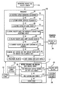
Figure 1 schematically depicts a flow diagram of combined methods of a
termination
decision by a processor including termination criteria, criteria detection by
sensing of geographic
position and velocity, and elements of operation according to certain aspects
of the invention. In
combination with an onboard power source 12 and GPS 14 (or other geographic
locator or
tracking system), a processor 10 is provided to receive position information
and time change of
position (velocity) information 14. The position information is compared to
stored or
programmed criteria information at 16, 18, 20, 22, 24, 26, 28 and 30, to
determine whether
termination of radio transmission and/or termination of flight should be
implemented.
The following criteria based decisions are provided with the processor 10:
Has the platform moved or drifted outside of a certain geographic area? (See
Fig. 1, at
16.)
The relevant boundaries may be frequency license borders set by the FCC as
dictated by a
regional or nationwide broadcasting license. The FCC prohibits transmitter
operation outside
such geographic borders. Additionally, a neighboring country may have
restrictions on
transmitted power into their country from a foreign transmitter. It has been
found that on certain
frequencies Mexico prohibits transmit power levels above ¨ 99dBm into Mexico
from the United
24
CA 02540693 2006-03-29
WO 2005/032936 PCT/US2004/032206
States. These restrictions are not hard for terrestrial towers to comply with
as the towers can
install and adjust directional antennas once during installation and not have
to adjust them again
thereafter. This is quite different for a free drifting high altitude
ballooncraft containing a
transmitter as the position and altitude may be constantly changing and may
require the platform
to stop transmitting while still inside the United States, but within a
protective number of miles
of the United States ¨ Mexico border. Long duration scientific ballooncraft
are not as concerned
with this as they typically work on special frequencies or have coordinated
with other countries
that may be over flown.
Is the platform moving outside of boundaries that would significantly reduce
the
probability of recovering the platform? (See Fig. 1 at 18.)
As payloads costs may be significant, from $50 to $150 for a typical weather
service
radiosonde, up to hundreds of dollars for a transceiver platform, and up to
many tens of
thousands of dollars for a scientific payload, recovery is important both
financially and for
environmental reasons. A platform may encounter strong winds especially in the
jet stream as it
descends from high altitudes. In order to keep the platform from drifting out
of the country on
descent, artificial borders that take into account the winds during descent
can be used. Also,
boundaries of large bodies of water such as the great lakes, seas and oceans
the crossing of which
might hamper or prevent recovery of the platform upon normal decent, may be
taken into account
for termination of flight purposes.
Has the platform fallen below or risen above a set altitude range? (See Fig. 1
at 20)
Most scientific and weather balloons reach altitudes above 60,000 feet, The
FAA
regulates airspace below 60,000 feet and discourages free floating craft or
uncontrolled flight
craft from loitering especially in commercial air lanes as they present a
hazard to commercial
planes. Current NWS weather balloons do not have the capability to terminate
the flight if they
start to hover below 60,000 feet. Even the large-scale scientific balloons may
become errant and
free drift below 60,000 feet. (see the rogue scientific balloon example listed
earlier).
CA 02540693 2006-03-29
WO 2005/032936 PCT/US2004/032206
Is the platform velocity sufficient to create an unacceptably large Doppler
shift in the
transmission frequency? (See Fig. 1, at 22)
A ballooncraft traveling in the jet stream may reach speeds of over 180 miles
per hour.
This creates a Doppler shift in the frequencies received on the ground. The
FCC regulates the
amount of total frequency drift allowed on transmissions. Doppler shift
contributes to this total
frequency drift and if great enough can cause the transmitter to transmit out
of its allowed band.
These requirements have not been considered or accounted for in the past as
free drifting
commercially transmitting platforms were not available. Therefore, the
requirement that the
payload be able to immediately stop transmitting past the speed at which the
Doppler becomes
too great is new.
Does the platform fall rate indicate a balloon burst? (See Fig. I, at 24.)
A fast fall rate indicates that the balloon has burst and that the craft is
falling.
Is the lighter-than-air platform rising too slowly during ascent? (See Fig. 1,
at 26.)
This indicates that the balloon is under-filled or leaking. A slow rise rate
may present a
danger to aircraft by loitering excessively at one altitude particularly at an
altitude in designated
air lanes.
Has the processor, the position finding equipment, or the primary power
failed?
(See Fig. I, at 28.)
A GPS, star tracker, or system power failure should initiate an on-board
termination. The
platform must be able to temiinate without processor control or power.
Have command and control communications been lost? (See Fig.1, at 30.)
Without command and control from the ground, the payload should cease
transmission
and the flight should be terminated.
26
CA 02540693 2006-03-29
PCT/US2004/032206
WO 2005/032936
The present inventive system detects the foregoing conditions by comparing
current
position, velocity, and operating conditions to stored, programmed or
calculated criteria using an
onboard processor or controller. The present invention utilizes a GPS unit and
a processor to
determine the current platform's geographic coordinates and velocities. A GPS
unit or pressure
sensor determines the platform altitude. The processor algorithms will
implement the complete
set of conditions listed above causing the ballast to be released at 34, the
transmitter to be shut
off at 38 and the flight terminated at 36 upon detection of a stored,
programmed or calculated
termination criteria. Under conditions of a power loss or processor failure,
the transmitter will
also be shut off at 38, and the flight will be terminated at 36. The methods
and mechanisms for
the termination actions are described more fully below.
A separate termination controller 11, which may be under separate power 13
monitors the
primary platform power at 32 and monitors processor functions at 30 to
determine if the
processor 10 is functioning properly. Both the primary processor 10 and the
separate termination
controller 11 have the ability to terminate transmissions, by discharging the
primary platform
batteries at 38 and to terminate the flight by releasing the balloon at 36.
The separate power
source 13 may advantageously comprise a very small environmentally acceptable
battery such as
an alkaline watch battery.
The present invention solves certain past needs. This invention describes a
system,
method and design for use with lighter-than-air platfoiiiis that overcomes
certain safety
drawbacks of conventional unmanned lighter-than-air ballooncraft. The
processor reduces or
eliminates the chance of the platform becoming a free floating, uncontrolled
transmitter by
monitoring sensed coordinates and platform velocities (GPS, star tracker, etc)
and by comparing
the sensed information to known (stored, programmed or calculated) geographic
or altitude based
boundaries. If the processor determines that the platform is out of it's
proper boundaries,
termination is started. If the GPS fails, the processor also initiates
termination. If the processor
function unacceptably fails or if the primary power fails, termination and
recovery is also
automatically initiated with a secondary termination control circuit having
its own small and
environmentally acceptable power source. This does not require power from the
primary power
source of the platform.
27
CA 02540693 2006-03-29
WO 2005/032936 PCT/US2004/032206
Termination and recovery comprise several steps or actions as follows:
Releasing all ballast to reduce the payload density and weight.
The following device allows for the controlled release of ballast (and
generation of lifting
gas) to reduce the ascent rate or slow down the descent rate. At termination,
all ballast is
released automatically according to a mechanism as schematically depicted in
Figure 2. Ballast
system and release mechanism
Both reactant A in Chamber A (100) and reactant B in Chamber B (101) is
metered into
the reaction chamber (104) where hydrogen generation occurs. The relative size
of each of the
two chambers is determined by the molar ratio of the reaction. If water is
used as one of the
reactants and a fuel cell is used on the platform for generating power, the
water byproduct of the
fuel cell's reaction may be used for the ballast system reaction as one of the
reactants. Different
metering rates would be required for each reactant if the molar ratio of the
reactants were not 1 to
1. This could be done with a dual peristalsis pump (102) if the tubing
diameters were adjusted to
pump the appropriate amount from each reactant chamber. During the reaction,
hydrogen is
vented from the reaction chamber through a tube (107) into the balloon. A one-
way valve (106)
in the tube to the balloon prevents hydrogen from flowing back into the
reaction chamber. After
the reaction is complete, the byproduct is dropped as ballast from the bottom
of the reaction
2 0 chamber (104) through an electrically actuated valve (105). The valve
(105) is then closed.
Upon flight termination, the reactants will be reacted as quickly as safely
possible in the reaction
chamber (104) and the byproducts dropped as ballast.
In a second configuration (not depicted), the ballast system comprises two
cavities each
containing one of the two reactants. The reactant in the top cavity is metered
into the lower
cavity where the hydrogen generation occurs. The reaction byproducts are only
released as
ballast when all of the original reactants are depleted.
In a third configuration, a hydrocarbon chain is reformed to produce hydrogen.
This
requires a catalyst such as platinum. Methods of reforming hydrocarbons to
produce hydrogen
28
CA 02540693 2006-03-29
WO 2005/032936 PCT/US2004/032206
are well known in the industry. The hydrogen is added to the lifting container
and the remaining
reacted reactants as dropped as ballast.
This method of hydrogen generation from the materials used for ballast
effectively makes
the payload lighter and therefore safer in the event of collision with
aircraft or persons and
property on the ground. While any acceptable ballast could be released, the
novel ballast system
described above effectively reduces the actual weight of ballast required by a
system thereby
increasing the safety of the payload. In the novel ballast system the total
amount of ballast
carried to provide long duration flight at an acceptable altitude is
significantly reduced. Reducing
the amount of ballast should in most cases increase safety. In one specific
example, the system
uses water and either Sodium Hydride or Calcium Hydride as the ballast. When
additional
altitude is required, a quantity of water is added to a quantity of Sodium
Hydride or Calcium
Hydride. A large volume of hydrogen gas is generated. This hydrogen is added
to the lifting
balloon and the byproducts of the reaction are dropped as ballast. The
platform becomes lighter
due to the dropping of the Ca(OH)2 or Na(OH)2 byproduct and at the same time,
hydrogen is
added to the balloon increasing lift. Only 73% (75% for Sodium Hydride) of an
equivalent
weight of inert ballast such as sand is needed. As ballast can be a
significant portion of the initial
total weight, reducing the weight of the ballast significantly reduces the
total weight of the
payload.
Releasing the neck of the balloon from the platform to initiate a quick
descent.
This makes sure the platform descends quickly through the atmosphere thereby
reducing
the potential time the payload passes through the commercial air lanes. Small
balloon systems
such as the NWS weather balloons rely on the balloon bursting due to expansion
as it rises
through the atmosphere. A hovering balloon does not experience this expansion
and therefore
must either have a system to burst the balloon or physically separate from the
balloon. Venting
the balloon is generally not acceptable because of the danger of the partially
inflated balloon
drifting laterally on the ground increases the chance of personal or property
damage. A further
problem would occur if hydrogen was used as the lifting gas. This could create
a possibility of
hydrogen remaining in the balloon after landing and contacting an ignition
source. Bursting the
29
CA 02540693 2006-03-29
WO 2005/032936 PCT/US2004/032206
balloon is also generally undesirable as a burst balloon still attached to the
payload may foul the
descent mechanism causing an uncontrolled descent. In the invention, the neck
of the
ballooncraft is released when power is lost or the processor fails eliminating
these potential
problems.
One possible implementation of the neck release mechanism as depicted
schematically in
Figures 3 and 4, comprises two concentric neck connection tubes (43) and (49).
The top tube
(43) is slid into and attached to the balloon (41) with a strap (42) or rubber
band (42) and fits
within the bottom tube (49), which is attached to the payload (51). The top
tube (43) is
restrained from sliding out of the bottom tube (49) by a piece of monofilament
line (47). While
top tube (43) and bottom tube (49) are restrained to each other, flexible seal
(44) prevents gas in
the tubes from leaking at the junction of the tubes. Each end of the
monofilament line (47) is
threaded through a small hole in flange (46) and tied off. The monofilament
line (47) is threaded
around two knobs (52) and also through and in contact with an electrically
resistive coil (48).
A second implementation of the neck release mechanism utilizes a tube that is
attached to
the neck of the balloon as in the first implementation. The tube is removably
attached to the
payload by one or more latches. When these latches are undone, the neck can
separate from the
payload.
In a third implementation of the neck release mechanism, a tube that is
attached to the
neck of the balloon as in the first implementation is axially aligned and
slides within or over the
second tube that is attached to the payload. A release pin or pins passes
through both tubes from
the side such that when the pin is removed, the tubes are free to separate
from each other. See
Figure 11.
When termination of the flight is called for, the ballast is preferably
released first and
then a current is passed through the resistive coil (48). The coil heats (48)
up and melts through
the monofilament line (47). The weight of the payload (51) now pulls the
bottom tube (49) from
the top tube and the payload is released from top tube (43).and thus from the
balloon (41). This
ballast system advantageously allows for the venting of the lifting gas
directly at the payload
eliminating the need for wiring to remote valves.
CA 02540693 2006-03-29
WO 2005/032936 PCT/US2004/032206
The battery discharge and neck release circuit.
The battery discharge and neck release circuit is schematically depicted in
Figure 5. The
processor must constantly supply a keep alive signal to the battery discharge
circuit in order to
prevent the batteries from discharging. This keep alive signal comprises a
square wave. The
battery discharge circuit senses the low to high transitions in the keep alive
signal and resets the
timer (a IMF 4060) each time a transition is detected. The timer must be reset
by the presence of
the keep alive square wave or the timer will end it's counting and initiate
the battery discharge.
A high power _VET closes the circuit that discharges the batteries. In one
implementation of the
discharge circuit, the power from the discharge circuit comes from the main
batteries themselves.
Because the discharge circuitry can function down to extremely low battery
voltages, the
batteries are effectively discharged by the time the discharge circuit is
unable to function.
An alternate implementation uses a separate, non-hazardous, small battery to
operate the
discharge circuitry. This implementation ensures that the main batteries are
completely
discharged. The discharge circuit dissipates power through the resistive wire
that during battery
discharge, dissipates the energy as heat. The resistive wire is wrapped around
a piece of
monofilament (fishing) line. When the battery power is dissipated through the
resistive wire, the
monofilament line is melted through and the neck connecting the balloon to the
platform is
released from the payload. Another advantage of providing a separate power
source for the
discharge circuit is that the discharge circuit battery will supply the
resistive element with power
to cut the monofilament line even if the main batteries are dead. As an
alternative, the discharge
circuit could dissipates power through a high power resistor if the neck
release function were not
used.
If the processor senses any of the conditions necessary to initiate
termination, it ceases
sending the keep alive signal to the discharge circuit. If the processor dies
or the power fails, the
keep alive signal also ceases, causing termination. The timer advances to a
point where it
initiates the battery discharge. Battery current flows through the resistive
wire discharging the
batteries and melting through the monofilament to release the balloon neck.
The battery
discharge continues until the main batteries are completely dead.
31
CA 02540693 2006-03-29
WO 2005/032936 PCT/US2004/032206
The main platform batteries are fully discharged during descent to positively
prevent
further radio transmission. Once discharge is initiated, the batteries fully
discharge. The
processor can initiate the battery discharge as described above or
automatically when power or
processor control is lost. It has been found that long duration flight at high
altitudes and cold
temperatures requires special high-density batteries. It has been found that
lithium batteries
beneficially fulfill such requirements. Additionally, it was found that the
Environmental
Protection Agency (EPA) states that lithium based batteries are considered
hazardous waste
except for one type of cell and only when fully discharged. Particularly it
has been found that
Lithium Sulfur Dioxide (LiS02) batteries, when fully discharged, form a
lithium salt, which is
not considered hazardous by the EPA. Automatically discharging the LiS02
batteries before
they contact the ground not only prevents the transmitter from transmitting
but also renders the
batteries non-hazardous.
The "maple seed" descent device.
Use of a novel and integral "maple seed" like descent device to increase
safety is depicted
in Figures 6, 7 and 8. A single airfoil shaped blade attached to the bottom of
the platfolui causes
autorotation of the payload and airfoil blade upon rapid descent. This
replaces a traditional
parachute with a highly reliable decelerator that is generally immune to
fouling and requires no
deployment mechanism and is also immune to fouling problems with animals and
property after
descent. The "maple seed" decelerator may also be used to conveniently house
the antenna.
This autorotation occurs because of the asymmetrical nature of the airfoil.
The center of
mass of the payload/airfoil combination is shifted well to the payload end
while its center of lift
is approximately in the middle. This causes a circular rotation of the entire
assembly around its
center of mass. The rotation actually inscribes a cone around the axis of
fall. The shape of the
cone will vary depending upon the aerodynamic qualities of the airfoil. An
airfoil with minimal
lift properties will inscribe a steep-side cone while an airfoil with strong
lift properties will
inscribe a very flattened cone.
Platform recovery.
32
CA 02540693 2006-03-29
WO 2005/032936 PCT/US2004/032206
A novel method of platform recovery is depicted in Figure 9. To aid in the
recovery of
the platform, the landed platform transmits its last recorded position to an
additional airborne
platform. The platform could determine that it had landed by comparing
sequential position
readings and noting when they consistently indicate no change in position. The
second platform
relays the current location of the landed platform to a ground station where
the position of the
landed platfonu is used to aid in recovery of the landed platform. A UPS unit
on the landed
payload could determine the position of the landed platform. The transmission
from the landed
platfomi to the additional airborne platform could utilize nearly any
commercially available or
custom transceiver.
The "handoff' mechanism.
Figure 10 shows the capability of handoff, i.e., handing off signal, between
platforms by
the communications devices. Figure 10 shows a schematic view of a portion of a
constellation
and communication network system in which 12(i), 12(ii) and 12(iii) air borne
platforms. Each
air borne platform comprises a lighter than air gas enclosure such as a
balloon, and a transceiver
(processor). Strong and weak signals between platforms and the communication
devices (user
equipment) 22v-z, located on or above ground, are shown by solid and dashed
lines 120. The
tracking antennas 126 could be located on ground terminal 124 or platfotm
launcher, i.e., SNS
launcher 46. Also, on the SNS launcher 46 could be a launcher 44. Lines 28
show the command
and control link between the tracking antennas 126 and platforms.
In particular, Figure 10 shows communication devices 22y and 22z communicating
with
platforms 12(ii) and 12(iii). The signal from platfomi 12(iii) is stronger (as
shown by solid lines)
than that from platform 12(ii) (as shown by dashed lines). When platforms
12(ii) and 12(iii)
migrate from left to right due to wind currents as shown in Figure 10,
communications devices
22y and 22z hand off communication with platform 12(iii) to platform 12(ii) as
platform 12(iii)
moves out of the communication range and platform 12(ii) moves to the former
position of
platform (iii). Generally, the processor(s) on board the platform(s) does not
hand off the signal;
it is the communication device(s) that initiates the handoff.
33
CA 02540693 2006-03-29
WO 2005/032936 PCT/US2004/032206
The communications signal transceiver comprises circuitry capable of
communications
using 141)MA, TDMA, CDMA, and ReFLEX protocols. All of these named protocols
use
"handoff." For example, United States Patent No. 5,649,000, issued July 15,
1997, discloses a
method and system for providing a different frequency handoff in a CDMA
cellular telephone
system. Devices using these protocols periodically scan for neighboring
control channel in the
background, without interrupting normal operations. If the device finds a
better channel, in terms
of significantly better signal strength or higher priority, it can request a
transfer. This is usually
done using "make before break," a concept similar to the soft hand-off used in
PCS phone
networks, where registration with a new channel is completed before
communication with the old
1 0 channel is broken. Normally, this means that a device will always be
registered with the
network, and capable of receiving messages. This permits communication devices
to move
quickly and efficiently across service areas with different control channels.
Another embodiment is a floating constellation communication system comprising
a
plurality of lighter-than-air platforms, each including an altitude regulator
device to control the
floating of said platforms within a predetermined altitude range, each
platform carrying at least
one communication signal transceiver; a plurality of geographically spaced-
apart platform
launching sites from which said plurality of platforms can be launched; a
plurality of ground
terminals capable of tracking one or more of said plurality of platforms, said
ground terminals
capable of transmitting communication signals to and capable of receiving
communication
2 0 signals from at least one of said plurality of communication signal
transceivers carried by said
plurality of platforms; a network of communication links interconnecting said
ground terminals
to one another; and a plurality of coded communication devices within a
contiguous geographic
area, said coded communication devices having communication capabilities
compatible with the
capabilities of said signal transceivers carried by said platforms.
2 5 Another embodiment is a floating constellation of communication
platforms comprising a
plurality of separately launchable lighter-than-air platforms capable of
initially ascending into the
Earth's atmosphere after being launched; each of said plurality of platforms
further comprising an
altitude regulator operatively connected to regulate each of said platforms to
float within a
34
CA 02540693 2006-03-29
WO 2005/032936 PCT/US2004/032206
predetermined altitude range after initial ascent; and a communication signal
transceiver carried by
each of said plurality of platforms.
Another embodiment is a floating constellation communication system comprising
a
plurality of lighter-than-air platforms regulated to float within a
predetermined altitude range, each
platform carrying at least one communication signal transceiver; a plurality
of geographically spaced-
apart platform launching sites from which said plurality of platforms can be
launched; a space
satellite and a network of satellite communication links between a plurality
of ground terminals
capable of said space satellite and of said plurality of platforms, and
capable of transmitting
communication signals to and receiving communication signals from said
plurality of
communication signal transceivers carried by said plurality of platforms; a
network operations center
(NOC) and a satellite communications link between said NOC and said space
satellite thereby
interconnecting said NOC and said plurality of platforms; and a plurality of
coded communication
devices within a contiguous geographic area having communication capabilities
compatible with
capabilities of said communication signal transceivers carried by said
plurality of platforms.
Another embodiment is a floating constellation of communication platforms
comprising a
first plurality of airborne platforms regulatable to ascend and float in the
air for a period of time
within a predetermined range of altitudes, said first plurality of airborne
platforms ascending at a first
time from geographically spaced-apart locations; a next plurality of airborne
platforms regulatable to
ascend and float in the air within said predetermined range of altitudes, said
next plurality of airborne
platforms ascending at a next time from said geographically spaced-apart
locations; a rapid deflation
system for removing said airborne platforms from the air upon malfunction or
improper location of
said airborne platform; at least one platform communications signal
transceiver attached to each of
said airborne platforms; a plurality of geographically spaced-apart ground
transceivers capable of
communication with said airborne platform; a network of communication links
interconnecting said
plurality of ground transceivers; and a plurality of coded devices having
communication capabilities
corresponding to the capabilities of said platforms and selectably addressable
by communication
signals from said platfoinis.
Yet another embodiment is a floating constellation of communication platforms
comprising a
plurality of airborne platfoims regulatable to float within an adjustable
altitude range and spaced
CA 02540693 2006-03-29
WO 2005/032936 PCT/US2004/032206
apart to provide substantially ubiquitous line-of-sight coverage over a
contiguous geographic area;
said plurality of airborne platforms including a plurality of communication
transceivers, at least one
of said plurality of communication transceivers carried by each of said
plurality of airborne
platforms; a plurality of ground terminals spaced-apart over said contiguous
geographic area for
maintaining substantially ubiquitous line-of-sight signal communication
between said
communication devices of said plurality of airborne platforms and said ground
terminals; a network
of communication links interconnecting said plurality of ground terminals; and
a plurality of coded
devices capable of communications with said plurality of communication
transceiver and addressable
from one or more of said plurality of platform-carried communication
transceivers.
Another embodiment is an airborne constellation comprising a plurality of
individual lighter-
than-air platforms spaced apart above a contiguous geographic area so that
substantially ubiquitous
line of sight coverage of said geographic area is provided; each of said
plurality of platforms
comprising an enclosure holding a regulated volume of low density gas so that
the total density of
said platfaiiii is lower than the atmospheric air up to a predetermined
altitude range; and each of said
plurality of platforms further comprising a signal transmitting device
attached to said enclosure by
which signals from said platfouu may be transmitted to said contiguous
geographic area.
Another embodiment is an altitude regulated lighter-than-air communications
platform
comprising a low density gas enclosure for holding a quantity of low density
gas; a transceiver
attached to said enclosure including electronic circuitry and an onboard
electrical power source; and
an altitude regulator attached to said platform to regulate the altitude of
said platform within a
predetermined altitude range, said altitude regulator comprising an altitude
deterinining mechanism;
a controllable vent from said gas enclosure and vent controls operatively
coupled with said altitude
determining venting of gas for regulating the altitude of said platform; and a
controllable ballast
release attached to said platform and ballast controls coupled with said
altitude determining
mechanism to release ballast for regulating the altitude of said platform.
Another embodiment is a free floating constellation communications system
comprising a
plurality of lighter-than-air platforms comprising at least a first platform
and a second platform,
the first and second platfoillis comprising a communications signal
transceiver and being free
floating without any longitudinal and latitudinal position control; and a
plurality of
36
CA 02540693 2006-03-29
WO 2005/032936 PCT/US2004/032206
communications devices within a contiguous geographic area, at least one of
the communications
devices having communications capability with the communications signal
transceiver; wherein
the at least one of the communications devices is capable of handing off
communication with the
first platfaim to the second platform as the first platform moves out of a
communication range of
the at least one of the communications devices, and wherein the free floating
constellation
communications system provides a line-of-sight coverage of wireless data to a
population on a
contiguous landmass and the plurality of lighter-than-air platforms are
launched in a manner such
that when in an operating range of 60,000 to 140,000 feet there is
substantially a relative distance
between the plurality of lighter-than-air platfoims. The free floating
constellation
1 0 communications system (CCS) could further comprise an altitude
regulator device; plurality of
geographically spaced-apart platform launching sites from which the plurality
of platforms can be
launched; a plurality of ground terminals; and a network of communications
links
interconnecting at least some of the ground terminals to one another.
Preferably, the regulator is
operatively connected to regulate the platform to float within the
stratosphere of the Earth.
1 5 Preferably, a predetermined altitude range within which the plurality
of platforms is regulated to
float comprises a range of about 70,000 feet to about 100,000 feet. The
regulator regulates the
floating of the platform within a predetermined altitude range and comprises a
quantity of
contained gas having a density less than the density of air within the
predetermined altitude range
and a controllable vent by which a portion of the quantity of contained gas
can be released to
2 0 reduce the buoyancy of the platform. The regulator comprises a quantity
of high density material
carried onboard the platform and a release device by which a portion of the
high-density matter
can be released to increase buoyancy of the platform. Preferably, the
regulator comprises: a
controllable gas vent; a controllable ballast release device; an altitude
determining mechanism;
and a control signal processor device connected with the transceiver, the
altitude detetmining
2 5 mechanism, the gas vent and ballast release so that the altitude can be
adjusted.
Preferably, the communications system of the plurality of spaced-apart ground
teiminals
comprises a transceiver. The CCS could further comprise a tracking device,
wherein the tracking
device comprises: a directional antenna; and a directional antenna aiming
mechanism responsive
to GPS coordinate data for selectively aiming the directional antenna at one
or more of the
37
CA 02540693 2006-03-29
WO 2005/032936 PCT/US2004/032206
plurality of platforms. The tracking device comprises: a directional antenna;
and a directional
antenna aiming and gain tracking mechanism for aiming the directional antenna
at a selected
platform according to communication signal strength between the selected
platform and the
directional antenna. Preferably, at least one of the spaced-apart ground
terminals comprises a
network operation center.
The CCS could further comprise a network operation center (NOC) connected to
the
network of communications links. Different variations on NOC connections are
the following.
The NOC is connected to at least some of the plurality of ground terminals
with a hub and spoke
arrangement of communications links. The NOC is connected to at least some of
the plurality of
1 0 ground terminals with a mesh arrangement of communications links.
Other variations are the following. The network of communications links
interconnecting
the ground terminals comprises connections to ground lines. The network of
communications
links interconnecting the ground terminals comprises space satellite
communications links. The
network of communications links comprises platform-to-platform communications
links.
Other variations include the following. The plurality of platforms comprise a
lighter-
than-air device selected from the group consisting of a balloon, a blimp, an
aerostat, a zeppelin,
an airship, a dirigible, a weather balloon, a jimsphere, a hot air balloon, a
sounding balloon and a
meteorological balloon and combinations thereof. The plurality of platforms
comprises rubber
balloons. The platforms have zero-pressure balloons, internal air bladder
balloons, adjustable
2 0 volume balloons or hydrogen-filled balloons.
Other variations include the following. The communications devices include
pagers,
advanced messaging devices, wireless telephones, telemetry devices or
equipment tracking units.
Still other variations include the following. The platform comprises a rapid
descent
mechanism; and the platform is disposable. The platform comprises a balloon;
the platform
2 5 comprises a rapid descent mechanism; and the balloon is replaceable for
recovery and reuse of
the transceiver.
Yet other variations include the following: The communications signal
transceiver
comprises circuitry capable of communications using Frequency Division
Multiple Access
(FDMA) protocol, Time Division Multiple Access (TDMA) protocol, Code Division
Multiple
38
CA 02540693 2006-03-29
WO 2005/032936 PCT/US2004/032206
Access (CDMA) protocol, the ReFLEX protocol, the Flex protocol the POCSAG
paging
protocol, or the ERMES paging protocol.
The CCS could further comprise an altitude determining mechanism; a source of
meteorological data; and controls for adjusting the altitude of a platform
into a wind velocity and
direction determined according to the meteorological data.
The CCS could further comprise an attitude sensor onboard at least one the
plurality of
platforms; and a steerable antenna coupled to at least one of the
communications signal
transceivers and attached to at least one of the plurality of platforms, the
steerable antenna having
stabilization controls for stabilizing the steerable antenna in a direction
from the platform
provides consistent ground coverage over the geographic area and an aim
control operatively
associated with the steerable antenna and the altitude sensor for selectively
changing the position
of the coverage area of the antenna to facilitate filling gaps of coverage
over the geographic area.
The CCS could further comprise an unmanned free balloon; and a payload box
having a
total weight less than six pounds and exterior surfaces with predetermined
areas and that has a
weight to size ratio of no more than three ounces per square inch on any
surface of the package,
determined by dividing the total weight in ounces of the payload box by the
area in square inches
of its smallest exterior surface.
Other variations include the following. At least one of the plurality of
platforms further
comprises an altitude regulator operatively connected to regulate the platform
to float within a
predetermined altitude range after initial ascent; wherein the altitude
regulator further comprises:
a quantity of high density material; a device for determining the altitude of
the platform, wherein
the device for determining the altitude of the platform comprises a global
positioning system
(GPS) receiver; and a material release mechanism for releasing a portion of
the quantity of high
density material.
The CCS could further comprise a hydrogen gas enclosure for holding a quantity
of
hydrogen; an onboard electrical power source on at least one of the platforms,
wherein the on-
board electrical power source comprises a fuel cell interconnected with the
hydrogen gas
enclosure for receiving hydrogen as a component of the fuel for the fuel cell;
and an altitude
regulator attached to the platform to regulate the altitude of the platfoim
within a predetermined
39
CA 02540693 2006-03-29
WO 2005/032936 PCT/US2004/032206
altitude range, the altitude regulator comprising: an altitude determining
mechanism; a
controllable vent from the gas enclosure and vent controls operatively coupled
with the altitude
detellnining mechanism for venting of the hydrogen gas for regulating the
altitude of the
platform; and a controllable ballast release attached to the platform to
release ballast for
regulating the altitude of the platform. In variations thereof, the
controllable vent and vent
controls are operatively coupled thereto further comprise at least one Nickel-
Titanium (NiTi)
element mechanically coupled to the control vent and operatively connected to
the electrical
power source for selectively receiving and not receiving electrical power to
thereby selectively
change the length of the NiTi element for opening and closing the controllable
vent. The CCS
could further comprise a meteorological package connected to the platform
through a fiber optic
link to the transceiver thereby substantially preventing electrical arcing
between the
meteorological package, the transceiver when the platform moves through
electrically charged
clouds and a tracking system capable of tracking one or more of the plurality
of platforms.
Other variations include the following. The network operation center comprises
circuitry
for controlling a predetermined operation of the platform.
The CCS could further comprise a rapid deflation system for removing a
platform from
the air upon malfunction or improper location of the platform.
Another embodiment is a free floating constellation communications system
comprising a
plurality of lighter-than-air platfoinis comprising at least a first platform
and a second platform,
each of the first and second platforms comprising a communications signal
transceiver and being
free floating without any longitudinal and latitudinal position control; and a
plurality of
communications devices within a contiguous geographic area, at least one of
the communications
devices having communications capability with the communications signal
transceivers; wherein
the at least one of the communications devices is capable of receiving
communications from the
communications signal transceiver of the first platform and the communications
signal
transceiver of the second platform, but hearing communications from only one
communications
signal transceiver and the plurality of lighter-than-air platforms are
launched in a manner such
that when in an operating range of 60,000 to 140,000 feet there is
substantially a relative distance
between the plurality of lighter-than-air platforms.
CA 02540693 2006-03-29
WO 2005/032936 PCT/US2004/032206
Yet another embodiment is a free floating constellation communications system
comprising a plurality of lighter-than-air platforms comprising at least a
first platform and a
second platform, each of the first and second platforms comprising a
communications signal
transceiver and being free floating without any longitudinal and latitudinal
position control; and a
plurality of communications devices within a contiguous geographic area, at
least one of the
communications devices having communications capability with the
communications signal
transceivers; wherein the first and second platforms dynamically assign new
frames in which to
transmit communication signal from the communications signal transceiver as
the platforms drift
such that a communications device receives communications signals from only
one
communications signal transceiver in a particular frame and the plurality of
lighter-than-air
platfoinis are launched in a manner such that when in an operating range of
60,000 to 140,000
feet there is substantially a relative distance between the plurality of
lighter-than-air platforms.
Yet another embodiment is a method of communicating using a free floating
constellation
communication system comprising providing a communication device for
communicating with
lighter-than-air platforms; communicating with a first lighter-than-air
platform when the
communication device is in a communication range of the first-lighter-than-air
platform,
communicating with a second lighter-than-air platform when the communication
device moves
out of the communication range of the first lighter-than-air platform, wherein
the first and second
lighter-than-air platfoims each comprise an altitude regulator device and a
communications
signal transceiver and wherein the first and second lighter-than-air platforms
are free floating
without any longitudinal and latitudinal position control and the plurality of
lighter-than-air
platforms are launched in a manner such that when in an operating range of
60,000 to 140,000
feet there is substantially a relative distance between the plurality of
lighter-than-air platforms.
Yet another embodiment is a method of communicating using a free floating
constellation communications system comprising providing a plurality of
lighter-than-air
platfouns comprising at least a first platform and a second platform, each of
the first and second
platforms comprising a communications signal transceiver and being free
floating without any
longitudinal and latitudinal position control; and communicating with a
communication device
having communications capability with the communications signal transceiver,
wherein the first
41
CA 02540693 2009-09-30
. 61181-160
and second platforms dynamically assign new frames in which to transmit
communication
signals from the communications signal transceivers as the platforms drift
such that a
communication device receives communications signals from only one
communications signal
transceiver in a particular frame and the plurality of lighter-than-air
platforms are launched in a
manner such that when in an operating range of 60,000 to 140,000 feet there is
substantially a
relative distance between the plurality of lighter-than-air platforms.
Another embodiment is a method for providing communication service comprising
providing a first lighter-than-air platform; providing a second lighter-than-
air platform, wherein
the first and second lighter-than-air platforms each comprise an altitude
regulator device and a
communications signal transceiver and wherein the first and second light-than-
air platforms are
free floating without any longitudinal and latitudinal position control;
providing a plurality of
communications devices within a contiguous geographic area, at least one of
the communications
devices having communications capability with the conununications signal
transceiver, wherein
the at least one of the communications devices is capable of handing off
communication with the
first platform to the second platform as the first platform moves out of a
communication range of
the at least one of the communications devices and wherein the free floating
constellation
communications system provides a line-of-sight wireless data coverage to a
population on a
contiguous landmass and the plurality of lighter-than-air platforms are
launched in a manner such
that when in an operating range of 60,000 to 140,000 feet there is
substantially a relative distance
between the plurality of lighter-than-air platforms.
42
CA 02540693 2009-09-30
,61181-160
Figure 12 depicts a schematic view of a portion of a constellation and
communication
network system 10 according to the present invention in which airborne
platforms 12(a)-(g) have
reached a desired altitude within a range of altitudes, such as in the
stratosphere. Also depicted is
an airborne platform 12(h) in the process of ascending to a desired altitude.
Each airborne
platform comprises a lighter-than-air gas enclosure 14(a)-(h), a platform
control and
communicator device 16(a)-(h) and an antennae 18(a)-(h). Platform-to-ground
communication
signals are schematically represented at 20(a)-20(u) correspondingly
communicating with a
plurality of ground communication devices such as radio signal receivers,
transceivers,
transmitters, or pagers 22(a)-22(u). There are a plurality of launch and
tracking terminals 24(a)-
(d), each having a plurality of tracking antennas 26(a)-(o). Ground terminals
relay message and
control data between the SNS platforms and the NOC. Preferably the ground
terminals can
operate unattended requiring only electrical power and communications signals.
The ground
terminals consist of a set of transmitters and receivers and their controller,
tracking antennas and
a tracking controller, redundant communications links to the NOC , and backup
power supply.
To accommodate the potentiality for several platforms within range at any
given time four to six
separate transmitters, receivers and tracking antennas are currently
contemplated. Both Genera
and Motorola offer appropriate commercially available transmitters,
transmitter controllers and
43
CA 02540693 2006-03-29
WO 2005/032936 PCT/US2004/032206
receivers for the SNS ground terminals although some modifications will be
required. The
tracking antennas 26 are schematically shown in communication with the various
platforms
through ground-to-platform signals 28(a)-(g). A ground communication network
30, having
interconnecting segments 30(a)-(d) are depicted communicating between the
launch and tracking
stations 24(a)-(d) and a network operations center 40. The network operations
center 40 may
also communicate with a plurality of launch and tracking terminals 24 through
an orbiting
satellite 32 and launch site satellite antennas 38(a)-(d) and network
operation center satellite
antenna 42. For purposes of illustration, launch and tracking terminal 24(c)
is co-located with an
airborne platform launcher 44 similar to or the same as the National Weather
Service balloon
launcher. One aspect of the invention also contemplates a mobile launcher and
tracking terminal
46, as for example a self-contained unit mounted on a truck trailer. The
mobile launcher can be
transported to a desired launch site, parked there and additional SNS
platforms can be launched.
The tracking and communication terminals 24 can be connected to the network
via ground links
30(c) and 30(d), as well as to other launch stations and to the network
operations center 40. The
mobile launcher and terminal may be moved periodically from one location to
another location to
launch and/or track additional SNS communication platforms 12(a) as needed to
fill in coverage
gaps as they might arise due to weather conditions.
Figure 13 is an enlarged schematic depiction of the mobile SNS launcher 46 of
Figure 12
shown schematically in relationship to platforms 12(f), 12(g) and 12(e) that
form a portion of the
constellation of platforms. The mobile SNS launcher is in communication with
the network
operations center 40. Further depicted in Figure 12 is a range of desired
altitudes 50 defined by a
minimum desired altitude 48 and a maximum desired altitude 52, each altitude
measured relative
to sea level 54. In one preferred embodiment, a minimum desired altitude of
about 60,000 ft. and
a maximum desired altitude of about 140,000 ft define a predetermined range of
altitudes. These
altitudes generally correspond to the Earth's stratosphere or to a range of
stratospheric altitudes
50. Further depicted in Figure 12 is a gap of coverage 56 between spaced-apart
platforms 12(g)
and 12(e) schematically represented as a spaced-apart distance 56 that is
significantly larger than
the desired spaced-apart distance 58 between platforms 12(f) and 12(g). In a
further preferred
embodiment, it is anticipated that platforms will be regulated to float within
a predetermined
44
CA 02540693 2006-03-29
WO 2005/032936 PCT/US2004/032206
altitude range of between about 70,000 ft. and 100,000 ft. will have a
coverage radius measuring
about 175 miles (280 km) will be above commercially regulated airspace and
will be below
altitudes at which platfomi survival is less certain. When the distance
between two adjacent
platforms in any direction is greater than about one and one-half times the
coverage radius, a gap
in coverage can begin to occur. In such instances, a mobile launching unit 46
can be moved on
the ground to a location substantially between the two spaced-apart platforms
12(g) and 12(e) so
that an additional supplemental platform 12(h) may be launched for rapid
ascent to the desired
altitude range 50. Computer modeling based upon the tracking of all the
platforms 12 in a
constellation 10 of airborne platforms can be used to predict the development
of significant gaps
56 in coverage and to rapidly deploy mobile launching units to fill the gaps.
In the event that a
stationary launching and tracking terminal is already in a location for
launching a supplemental
SNS platform, no mobile unit would be required.
Figure 14 is a schematic depiction of inter-platfolin communications with
subsequent
transmission to ground terminals and to a network operation center (NOC).
Figure 15 is a schematic depiction of platform-to-space satellite
communication links for
providing the network interconnection with a network operation center (NOC).
Figure 16 is a schematic depiction of a "hub and spoke" network communication
link
topography. This is advantageous because it is generally less total
communication lines and
generally less expensive equipment than by providing a ring topology.
Figure 17 is a schematic depiction of a mesh network communication link
topography.
Ring topology essentially daisy chains all of the ground stations together in
one, big ring of
communications links. This ring is generally considered to lack robustness. If
one or two points
go down on the ring, it could isolate otherwise functioning ground terminals.
Figure 18 schematically depicts a contiguous geographic area 100, and in
particular by
way of example, a geographic area corresponding to the United States of
America.
Superimposed on the geographic area 100 are 70-selected standard launch sites
represented by
"Xs" 101-170. Further schematically depicted are coverage areas 201-270
representing the
position and coverage of each of the platforms 101-170 as they reach a desired
regulated altitude,
preferably in the stratosphere. Each platform is very small compared to
existing synchronous
CA 02540693 2009-09-30
,61181-160
orbit satellites such that they have been referred to and are designed to
float in a regulated
altitude in the stratosphere such that they have been designated as
"stratospheric nanosatellites"
(SNS). The coverage areas 201-270 are depicted in Figure 18 assuming a
relatively vertical
ascent from the launch sites 101-170. The coverage areas 201-270 will migrate
over a period of
time, due to wind and weather conditions in a particular locality. However,
the ascent to the
stratospheric desired altitudes normally takes from about one to two hours,
such that the drift for
normal airspeeds of less than about 10-20 mph and even passing through the jet
stream if present
will produce relatively small drifts of 10-80 miles in any direction during
the ascent. Thus,
relative to the approximately 175-mile (280 km), coverage radius for a
circular coverage area
having a diameter of about 350 miles (560 km), the migration during a short
period of time with
standard wind conditions of 10-40 miles, indicates that the launch site is a
reasonable
approximation for the initial high altitude location at the end of the ascent.
The platform for balloons 12 are provided with altitude control mechanisms,
including
both low density gas venting and high density ballast dropping mechanisms,
allowing the balloon
to be controlled to maintain a desired altitude within a range of desired
altitudes. The altitudes
may be maintained for between 12-24 hours corresponding to the current NWS
balloon-
launching schedule of two launches per day. If the NWS launching schedule is
not used, the
balloon altitudes may be maintained for over 100 hours depending on the lift
gas, power, and
ballast remaining on the balloon 12. In the case of NWS balloons, currently
the balloons self-
destruct from overexpansion as they reach and exceed altitudes of over 100,000
ft. and weather
data is gathered and transmitted to the ground during the ascent. In the case
of balloons acting as
carriers for the communication platforms, the platforms will be maintained at
an altitude
preferably less than 140,000 ft. And more preferably less than about 100,000
ft. and will continue
to migrate due to upper stratospheric wind conditions. The NOC may command a
SNS platform
. 25 to rapid deflate or burst in the case of a balloon 12, when the
platform is no longer needed, it falls
below the 60,000 ft. and no ballast remains, it drifts over an undesired area,
or it malfunctions.
The platform may initiate this if any of these conditions are met and the
platform has lost
communication with the ground terminals. Advantageously, the wind conditions
will have been
detected during the ascent and will continue to be monitored through the
tracking by the ground
46
CA 02540693 2009-09-30
6 1 1 8 1- 1 6 0
stations. This will facilitate predicting the development of any gaps in
coverage that might be
expected, and particularly the location of such gaps and the number of ground
communication
devices or pagers that might need to be serviced in the area of the gap.
Figure 19 is a schematic depiction of the geographic area 100 after a given
migration time
period during which significant gaps may begin to occur. Mobile units may be
positioned at
temporary launch sites 171 and 172 for filling developing gaps 56(b) and
56(c). Also, where a
gap is predicted to develop in close proximity to a standard launch site, as,
for example, at 105,
an additional platform may be launched from launch site 105 in advance of the
normally regular
launch time period. Thus, gap 56(c). In a similar manner, a plurality of
typically regionally
located mobile launch sites may be employed to fill gaps as they arise. In the
event that a pattern
of gap development is detected, then additional permanent launch sites 173 and
174 may be
added to help compensate for repeated developments of gaps 56(d) and 56(e),
for example.
Temporary launch sites may be moved seasonally to fill the gaps along the
coast line along the
direction the wind is blowing for the season, for example, the western coast
during the winter
season.
Figure 20 shows a schematic side elevation view of a platform 12 in an
embodiment in
which the low-density gas enclosure 70 is preferably a latex balloon 70. A
Totex 1000 balloon
filled with hydrogen and internally coated to reduce hydrogen diffusion
adequately provides lift
for the SNS communications platform. The Totex balloon is released with a
diameter of about
five and one-quarter feet and expands to about twenty-four feet across at
140,000 feet altitude. It
will be noted that other lighter-than-air enclosures, such as blimps,
aerostats, zeppelins, airships,
dirigibles, weather balloons, jimspheres, hot air balloons, sounding balloons
or meteorological
balloon might also be used in place of the proposed latex weather balloon 70
schematically
depicted in Figure20. Also, the diameter of balloon 70 in Figure 6 is not to
scale and it is
expected that a total platform weight, including the payload box 300, altitude
control vent
mechanism '72, meteorological package 82, antennae 76 and meteorological cable
connection 84.
Preferably the cable 84 is a fiberoptic cable having a length of approximately
25 meters so that
the meteorological data collection package 82 is sufficiently distanced from
the balloon 70 to
reduce to a minimum the effect of turbulence caused by the balloon on the
meteorological data
47
CA 02540693 2006-03-29
WO 2005/032936 PCT/US2004/032206
sensed by the meteorological package 82. The fiberoptic cable 84 is used to
transmit the
meteorological data from meteorological package 82 to the communications unit
74. Fiberoptic
cable is used as wire would arc due to the high electric field potential when
passing through
thunderclouds.
There are numerous types of low-density gas enclosure devices, and
particularly balloons,
that might be considered useful for the present invention. Among the
potentially preferred types
of balloons are rubber pressure balloons, zero pressure balloons, internal air
bladder balloons,
adjustable volume balloons and super pressure balloons. Each type of these
balloons has
different advantages and disadvantages and, for purposes of the present
invention, it has been
found that the rubber pressure balloon is most preferred and the zero pressure
balloon is also
considered a preferred alternative.
The rubber pressure balloons have a stretchable rubber membrane containing the
lifting
gas that allows the balloon to increase in size as the external air pressure
decreases as the balloon
rises. This is the most common type of weather balloon and is also consistent
with party
balloons. The primary advantage is the low cost and common accessibility so
that high quality
balloons of this type, such as weather balloons, are available at low cost.
These balloons are
somewhat fragile and they have delicate handling requirements and also low
extended reliability.
Further, the use of such balloons requires venting of the lifting gas to
prevent bursting upon
reaching maximum altitudes.
2 0 The zero pressure balloons consist of an initially loose bag, usually
made from a plastic
such as polyethylene or Mylar. As the external air pressure decreases, the bag
increases in
volume. Once the bag reaches its whole volume, gas must be vented or the
balloon will burst as
the bag material does not stretch. Although this type of balloon may be more
reliable than the
rubber balloons and provide less diffusion of the lifting gas, it is of a
median cost, more costly
than the rubber balloons, currently between about four to ten times more
expensive. Thus,
although the rubber balloon might be more prefeiTed for purposes of low cost
platforms, the zero
pressure balloon also provides a useful enclosure for lifting the platform up
and has certain
advantages over the rubber pressure balloons.
48
CA 02540693 2006-03-29
WO 2005/032936 PCT/US2004/032206
Internal air bladder balloons consist of a flexible balloon containing air
enclosed in a
fixed volume balloon contain a lifting gas. Air is pumped into the inner-
flexible balloon, which
compresses the lifting gas trapped in the fixed volume balloon, thereby
decreasing the overall lift.
Air is let out of the inner-flexible balloon to increase lift. Blimps adjust
lift using this principle.
This type of balloon has certain advantages as there is no lift gas lost when
reducing lift and it is
potentially more reliable than rubber balloons, however it is more costly due
to extra balloon,
pump and extra required power for operating the increase and decrease of lift
mechanism.
Adjustable volume balloons consist of a fixed volume containing the lifting
gas and a
mechanical way of reducing the volume of the balloon. By decreasing the
volume, the lifting gas
is compressed and the lift decreases. The volume may be reduced any number of
ways, including
an adjustable line inside the balloon from the top of the balloon volume
decreases. This has less
diffusion of the lifting gas, theoretically, lifting gas is not lost when
reducing lift and it may be
more reliable than rubber balloons. However, it has a significantly more
costly due to the
mechanical volume reducing mechanism and further, requires extra power for
operation of such a
mechanical volume-reducing mechanism.
Super pressure balloons have a fixed volume. They are called super pressure
balloons
because they do not expand to match the decreasing exterior pressure. They are
built strong
enough to hold the increased pressure. The balloons can achieve extremely long
float lies
because they do not need to vent gas to prevent bursting and they typically
have very low
membrane gas diffusion. This type of balloon is the highest cost, although one
of the most
reliable, with little loss of lifting gas. The extreme high cost and
difficulty of manufacture and
the lack of developed technology regarding such balloons, indicates that other
alternatives are
currently more attractive.
A signal transmission antenna 76 extends from the communication device 74
preferably
vertically downward from the communication device 74 and preferably a
collinear array with
approximately a 6 degree down tilt configured to provide even transmission and
reception
coverage over the entire circular coverage area. The antennae 77 may
advantageously be
provided with a support loop 86 to facilitate stabilization between the
antennae and the
meteorological connection cable 84. Also depicted in Figure 6 is a balloon
destruct mechanism
49
CA 02540693 2006-03-29
WO 2005/032936 PCT/US2004/032206
78 and a parachute 80 for recovery of the communication device 74, when the
balloon is
destroyed by the controlled destruct mechanism 78 or otherwise by natural
causes.
Figure 21 depicts a partial cross-sectional front view of one embodiment of a
communication device 74 according to the present invention. There is a payload
box 300,
including an interior container 302 and exterior Styrofoam insulation 304
surrounding the
interior container 302. Within the container 302 is a circuit board 306 to
which various
electronic components are attached and interconnected to provide signal
communication and
remote control of the platform as desired. The electronics section consist of
the RF section,
antennas, GPS receiver, processor and power regulators. The RF section is
based on the low cost
transmitter and receiver section of current two-way pagers. The transmitter
power is increased to
approximately 7 watts. A single 900 MHZ collinear dipole array antenna serves
both for transmit
and receive functions. Additional antennas may be added for gateway RF links
to the Ground
Terminals if the additional frequencies become available. Possible frequencies
include the 1680
MHz band assigned to meteorological instruments. If the SNS system also
collects weather data
for the NWS and this data is transmitted on the meteorological aids band, it
may be possible to
send additional gateway traffic with the meteorological data. A twelve channel
GPS receiver in
conjunction with the processor provides positional information to both the
NW'S during ascent
and to the SNS NOC for the entire flight. The NOC uses the information to
locate the SNS
platforms, to determine coverage holes or gaps, and to make rudimentary
position adjustments by
2 0 varying the altitude into favorable wind speeds and directions.
The embodiment depicted in Figure 21 and the side partial cross-section
thereof as
depicted in Figure 22 shows the power for the communication device 74 being
provided by a
plurality of lightweight, high power batteries 308(a), (b), (c) and (d). The
platform may require
between about three and eighteen watts of power depending on the message
traffic and the
platform configuration. Lithium sulfur dioxide (LiS02) batteries are cost and
weight effective
and have decent operating characteristics in a low temperature environment as
found at high
altitudes. The batteries are positioned at spaced-apart alternating positions
so that maximum unit
volume density is maintained below established maximum unit volume density
requirements for
federal aviation safety standards. The low unit volume density and low total
payload weight
CA 02540693 2006-03-29
WO 2005/032936 PCT/US2004/032206
keeps the launching of the balloons from being restricted by FAA regulations.
There is a bottom
opening 310 through which the meteorological connection cable 84 connects at a
releasable cable
connector 312 to the circuit board 306 inside of the container 302. Also,
antennae 76 is attached
at an antennae connection 314 located in the bottom opening 310 so that
signals may be received
or transmitted through the antennae 76 to and from circuit board 306.
Meteorological data from
fiberoptic cable 84 may be received and processed in components of the circuit
board 306 or may
be transmitted directly to the ground terminal 24 through antennae 76. Active
antennae
stabilizers 316 are provided to reduce and dampen movement of antennae 76 so
that consistent
signal reception and transmission is accomplished. To facilitate regulation of
the altitude of the
airborne platfoim 12 and the attached communication unit 74, the payload box
300 includes a
ballast storage chamber 320 in which ballast 318 is carried. Ballast 318 is
preferably easily
moveable lead shot, metal BBs or spherical glass beads that may be
controllably released as with
a ballast drop gate, such as a shuttle, that moves alternatively between
opening into the ballast
chamber 320 and then to the ballast outlet orifice 324, such that the ballast
may fall from the
bottom opening 310 as schematically depicted at 326. For convenience and for
avoiding power
depletion during storage or transport, a manual circuit activation switch 328
is provided.
At the top of the payload box 300 is a balloon connection spindle 334, having
a distal
neck top 332 over which the flexible balloon connection neck 330 is attached.
The balloon
connection neck 330 is sized for fitting over the spindle and is stretched and
moved down to a
stop lip 336 so that it is secured in position with one or more heavy rubber
bands 338. For
convenience, a rubber band storage channel 340 is provided below the stop lip.
A rubber band is
stored and in position for securing a "fresh," lighter-than-air enclosure or
balloon 70. Preferably,
balloon 70 will be filled with helium (He), hydrogen or natural gas through a
light gas fill valve
344 that is preferably positioned above a rain hood 342 that shields the
payload box and certain
components thereof from rain and other precipitation. The light gas fill valve
344 provides for a
convenient connection to a light gas supply tank, such as a helium or a
hydrogen supply tank, so
that an expandable balloon is attached at its neck 330 to the spindle 334 and
fill gas can then be
supplied in a desired amount into the attached enclosure or balloon. A gas
pressure sensor tube
346 communicates between the interior of the spindle to relay the internal
balloon gas pressure
51
CA 02540693 2006-03-29
WO 2005/032936 PCT/US2004/032206
sensor 348 connected to the electronics of the circuit board. A gas
temperature sensor 350 is
attached and is desirably positioned at or above the neck top 332. A
temperature sensor wire 352
communicates a signal representing the temperature to appropriate circuitry on
the circuit board
306. An ambient air temperature sensor 354 is also desirably provided, as well
as an ambient air
pressure sensor 356, both of which are connected for communicating the sensed
ambient air
temperature and the sensed ambient air pressure to the circuit board. A
battery temperature
sensor 358, a payload temperature sensor 360 and an attitude sensor 362 may
all be connected to
the circuit board 306 to desirably provide information and input for remote
controlling and for
maintaining the functions of the airborne platform 12 using the circuit 306.
The data collected
from the gas temperature sensor 350, the ambient air temperature sensor 354,
the gas pressure
sensor tube input 346, and the ambient air pressure sensor 356 is used, in
part, to determine if the
balloon is nearing a burst condition. A heater and cooler device 364 is
attached to control the
interior temperature of the payload box. As the airborne platform ascends into
high altitudes, the
ambient temperature drops dramatically and the interior of the box will
desirably be heated by
heat generated by the batteries or, alternatively, by the heater 364. If the
heat from the batteries is
significant and is combined with, for example, bright sunlight, the interior
temperature might
increase above desired operating temperatures, then the cooler portion of
heater and cooler
device 364 may be activated to maintain a desired operating temperature range.
The heater and
cooler device may be a thermoelectric cell.
For purposes of regulating the altitude of the balloon and, in particular, to
avoid
continuous ascent above the desired maximum high altitude, a light gas relief
valve 366 is
provided. A spring 368 keeps the relief valve 366 noimally closed. An actuator
rod 369 is
attached to the valve 366 and to a valve actuator wire 370, to open the valve
against the spring
loading. A Nickel-Titanium (NiTi) wire may be used as the actuator wire 370.
Light gas relief
valve 366 opens against the spring loading when a small amount of current is
passed through the
NiTi wire causing it to shrink or shorten a predetermined amount so that the
relief valve is pulled
open, thereby allowing lighter-than-air gasses to escape. The actuator rod may
pass through the
top of the container 302, preferably through a seal 371, so that the interior
of the container is not
directly exposed to the elements. The ballast shuttle gate 322 may similarly
be activated with a
52
CA 02540693 2006-03-29
WO 2005/032936 PCT/US2004/032206
ballast drop actuator wire 372, also made of Nickel-Titanium (NiTi). The
active antenna
stabilizers 316 may similarly be comprised of NiTi wire.
A meteorological drop control wire 374 may also be NiTi and can be used to
disconnect
the weather sonde after meteorological data is no longer being obtained.
Typically, weather
balloons burst after they pass through the stratosphere. Here, the balloon
will vent some of the
light gas to hold at a stratospheric altitude for desired period of time. The
destruct mechanism 74
may be remotely activated with the sharp end 378 of a pivotal destruct arm to
cause the platform
to fall. The destruct arm 376 is spring-loaded for rapid rotation into contact
with the exterior of
the balloon when a hold release pin 386 is pulled from engagement in a
hold/release groove 384.
The release pin 386 may advantageously be controlled with a control wire 388
also appropriately
activated through the circuit board upon receipt of remote signals through the
antennae 76 or
from the processor. Also provided inside of the platform is a GPS antennae 390
connected to the
circuit board for reception of position information from The GPS satellite
system to facilitate
tracking of the platform as it migrates and floats over the contiguous
geographic area of
coverage.
Figure 23 is a schematic side partial cross-section of an alternative
embodiment of the
platform according to the present invention in which the electrical power
source for the
communication circuit and controls is a fuel cell 400. Fuel cell 400 may
advantageously be a
proton exchange membrane (PEM) fuel cell of the type that uses hydrogen and
oxygen to provide
2 0 electrical power. This type of system requires a hydrogen tube 402
connecting from the source of
hydrogen, i.e., the lighter-than-air balloon 70 to the fuel cell 400. A
hydrogen inlet 404 is
provided with a hydrogen circulator 406, which may simply be a fan 406. Thus,
using the
hydrogen tube, hydrogen may be extracted from the balloon and inlet into the
fuel cell 400.
Also, there is a hydrogen outlet 408 that is recycled back to the balloon. A
hydrogen tube
pressure sensor 410 is provided to appropriately monitor the hydrogen partial
pressure at the fuel
cell. A fuel cell of this type also requires an oxygen supply that may be
provided by attaching an
oxygen balloon 414 to an oxygen tube 412 so that the oxygen balloon is inside
of the hydrogen
balloon enclosure. The oxygen balloon is constructed to hold the oxygen at a
significant internal
pressure. This oxygen balloon 414 may be attached to tube 412 with a rubber
band 416 and an
53
CA 02540693 2006-03-29
WO 2005/032936 PCT/US2004/032206
oxygen pump 418 moves and further pressurizes oxygen from the oxygen balloon
414 into the
fuel cell through an oxygen inlet 420. Again, to regulate the process an
oxygen pressure sensor
422 is provided. The fuel cell reaction results in water as a byproduct. The
water is maintained
in a liquid state by the heat generated by the fuel cell and is desirably
drained before it can freeze
at the high altitudes at which the platform operates.
Figure 24 is a schematic block diagram of the SNS platform hardware contained
within
the payload box 300 and placed on or interconnected with circuit board 306. A
processor 430
receives electrical signal input and provides electrical signal output,
interacting with a plurality of
components for both controlling the flotation altitude, temperature, balloon
destruction, ballast
drop, etc. of the platform and also for receiving, processing and transmitting
communication
signals received and transmitted to and from ground stations, personal
communication devices or
other information communications. Initially, block 432 represents either the
batteries 308 or the
fuel cell 400. Block 434 represents the on/off switch 328 to activate
providing power to a power
supply regulation circuit 436 with output available power 438. For clarity,
individual power
connections to various operational and control devices have not been shown in
all instances.
Power is provided to the supply voltage sensor at block 440 and current supply
sensor block 442,
which provide information to an analog to digital converter 444. The analog to
digital converter
also variously receives information from the payload and battery fuel cell
temperature gauge at
block 446, both gas and ambient air temperature readings at block 448 and gas
pressure at block
450. Additional analog informational signals are generally represented by
block 452. Digitally
converted information is variously provided to and received from flash memory
at block 454 and
random access memory (RAM) at block 456. From AID converter 444 and also from
the flash
memory 454 and from RAM memory 456, the processor has access to all the
various input
control data. During the ascent of the SNS platform, the meteorological
package represented by
block 458 receives appropriate weather information including ambient
temperature 460, ambient
pressure at 462 and ambient humidity at 464. The antenna stabilization 316
represented by block
496 may rely upon the attitude sensor information that is part of the SNS
platfoim control system
at 466 to stabilize the antenna 76. Information sensed or gathered by the
meteorological package
458 is transmitted. For example, the infrared transceiver 468 through a
fiberoptic cable at block
54
CA 02540693 2006-03-29
WO 2005/032936 PCT/US2004/032206
470 corresponding to the physical fiberoptic cable 84 and a processor infrared
transceiver 472 by
which serial meteorological data is transferred to the processor 430 for
appropriate transmission
to ground tetininals during the ascent of the SNS platform with the
meteorological package 458
attached. A GPS antennae block 474, corresponding to physical GPS antennae
390,
communicates through a GPS receiver 476, indicated as a serial port and
further synchronized
with a GPS clock or seconds tick at block 478. Thus, the position at
particular times is provided
to the processor. This positioning information is coordinated with the other
meteorological input
for determining wind speeds steering any part of the ascent, thereby
corresponding those wind
speeds to particular altitudes and geographical locations during the ascent.
Communications are controlled by processor 430, preferably using both a 900
MHZ
transceiver and modem 480 and a Gateway transceiver and modem 482 signal to
and from co-
linear array antennae 484 are interfaced through a diplexer 486 control
information received at
co-linear away antennae 484, therefore transferred through the diplexer and
one of the
appropriate frequency transceivers to the processor 430 with input information
from ground
signals and also from input information from the onboard sensors as provided
through AID
converter 444, the GPS position information from 476, the GPS time information
478 and the
attitude sensor information 466, various functions of the SNS platform can be
controlled.
Including the gas vent at block 488 corresponding the gas vent actuator 370.
Also the ballast
drop is controlled at block 490 corresponding to the physical ballast drop
actuator 372. The
meteorological package drop controlled schematically at block 492
corresponding to the package
drop actuator 374. The balloon destruct control is depicted at block 494
corresponding to the
destruct actuator 376. Antennae stabilization may be affected according to
controls at block 496
corresponding to the antennae stabilization mechanism 316. Payload temperature
controls, both
heating and cooling, may be controlled at block 498 corresponding to heaters
and coolers 364.
Additional functions as may be additionally included, are provided with
controls at block 500
One embodiment of this invention relates to a LTA rise rate control system. A
typical
National Weather Service balloon system, as is well known, consists of a
rubber extensible
balloon filled with a lifting gas, a parachute tied to the balloon, a line
extending down from the
CA 02540693 2006-03-29
WO 2005/032936 PCT/US2004/032206
parachute and a radiosonde tied to the end of that line. The radiosonde
collects and transmits
weather related data down to a ground station as the balloon system rises
through the atmosphere.
The National Weather Service requires that weather balloons rise at a standard
rate of
1000 feet per minute. This is nearly impossible to maintain throughout the
balloon's rise due to
many factors including the variance with altitude of the pressure and
temperature of both the
lifting gas and the ambient air, the variance in the balloon material, the
manufacturing process,
and the physical change in the size of the balloon itself as the balloon
rises.
In addition, a significant number of NWS weather balloons do not obtain the
desired
altitude of 100,000 feet because, among other factors, the balloon expands
significantly when
1 0 obtaining the higher altitudes, becoming thin and many times bursting
early for the same reasons
as listed above. If the amount of gas could be reduced at the higher
altitudes, the chance of
balloon burst would be decreased.
The present invention utilizes a rise rate control system to vent the lifting
gas as needed to
slow the balloon's ascent to no more than 1,000 feet per minute. Additionally,
by venting the
1 5 lifting gas, the balloon size is reduced, increasing the probability of
reaching the desired 100,000-
foot altitude without bursting.
The rise rate control system consists of a venting mechanism attached to the
neck of the
balloon that can release lifting gas from the balloon, a vent actuator for
opening and closing the
venting mechanism, an altitude sensor for determining the altitude and rise
rate of the balloon
2 0 system, and a comparing mechanism or circuit to control the vent
actuator to cause the vent to
release some lifting gas when the desired rise rate is greater than the
desired value.
In one embodiment, a GPS unit provides the processor with rise rate infat
nation. The
processor compares the current rise rate with the desired rise rate stored in
the processor's
memory. For the National Weather Service balloon systems, the desired rise
rate is 1,000 feet
2 5 per minute. If the current rise rate is higher than the desired rise
rate, the processor directs the
actuator to open the vent until the desired rise rate is achieved.
Additionally, a ballast system containing a ballast container, ballast, and a
ballast actuator
could be added to the rise rate control system. The processor compares the
current rise rate with
a minimum desired rise rate stored in the processor's memory. If the current
rise rate is lower
56
CA 02540693 2006-03-29
WO 2005/032936 PCT/US2004/032206
than the desired minimum rise rate, the processor, may activate the ballast
actuator to drop ballast
until the rise rate increases to the desired value.
The processor may first process the rise rate data coming from the GPS unit by
filtering
the rise rate values. This filtering may be necessary as the GPS data may be
noisy. Additionally,
erroneous data may be present and need to be removed from the GPS data. The
need for filtering
or removing of erroneous data will vary with the different makes and models of
GPS units.
Alternatively, mechanical means for determining the rise rate may also be used
instead of using
rise rate information from a GPS unit.
Another embodiment perfoinis transmitter geo-location from a LTA platform.
Having
the capability to locate specific wireless devices can be extremely valuable.
For example,
locating a lost semi trailer outfitted with a wireless locating device could
save a trucking
company many thousands of dollars. Locating a wireless caller experiencing an
emergency could
save the caller's life by appropriately directing emergency services. Many
wireless device
manufacturers are incorporating GPS into their devices but for many devices
this is not yet
appropriate due to cost, size, battery power demands, the poor signal
penetration of GPS in the
operating environment, or other factors. Legacy devices will continue to exist
in the marketplace
that do not have the capability to provide their own location.
This invention provides a method of geo-locating a received signal by
utilizing signal
path delay measurements taken from one or more free drifting, high altitude
lighter-than-air
platforms. The method has the following advantages: The invention does not
require the
wireless device that it is tracking to contain position determining circuitry
such as GPS thereby
reducing the size, cost, weight and power of the mobile transmitter. It works
with currently
available wireless devices such as wireless phones, two-way pagers, advanced
messaging
devices, wireless Internet access devices, and almost any wireless information
access device to
add location capabilities without requiring modification. It has higher
accuracy than solely using
the knowledge of which tower or towers are currently receiving the mobile
transmitter signal
even with the use of sectored antennas. It does not require specialized
directional antennas.
Extremely large coverage areas can be provided from a single receiver.
57
CA 02540693 2006-03-29
WO 2005/032936 PCT/US2004/032206
The present invention utilizes multiple signal path delay measurements by high
altitude
platforms of the received signal from a wireless device to determine the
wireless device's
position. This method can either be used to locate wireless devices registered
on a network
supplied by the high altitude platform, or to provide or supplement the
location capabilities of
existing terrestrial based wireless networks of wireless devices registered on
their network. In
the later case, the high altitude platform needs only to measure the signal
path delay of the
wireless device and does not need to decode the wireless device's traffic.
This invention works with wireless transmitters whose transmissions are time
synchronized to a standard. This standard may be GPS time or the timing of the
network that the
13 received wireless device is registered on. In most situations, the
timing comes from the
platform's forward channel transmission to the wireless device. In this case,
all wireless devices
on the platform's network have their timing synchronized with the received
transmissions from
the platform. The wireless device then uses this timing for transmissions back
to the platform.
Because of this, the start of a signal received at the platform from a
wireless device is delayed by
twice the signal path delay of the distance between the platform and the
wireless device (Figure
25). This signal path delay is measured by the platform and later converted to
a distance. The
distance from the platform to the wireless device is roughly Distance in
meters = 300,000,000 *
measured signal path delay in seconds / 2.
If the platform uses a non directional antenna and the wireless device is on
the ground, a
rough circle can be traced on the surface of the earth with the platform as
the center of the circle.
The radius of the circle is the distance from the platform to the wireless
device. The wireless
device is located on this circle (Figure 26). As the trace is the intersection
of the surface of the
earth with a measured distance from the platform (the distance calculated from
the signal path
delay), and the earth's terrain is not spherical, the trace does not form an
exact circle.
A platform in a different position above the earth receiving the signal from
the same
wireless device also measures a signal path delay. This delay is also
converted to a distance and
can roughly trace out a circle drawn on the surface of the earth of the
possible locations of the
wireless device as described above. Again, this does not form an exact circle
due to the earth's
58
CA 02540693 2006-03-29
WO 2005/032936 PCT/US2004/032206
terrain. The intersections of these two rough circles give the two potential
locations of the
wireless device (Figure 27).
A third position of a platform receiving the signal from the same wireless
device also
measures a signal path delay. This delay is also converted to a distance and
can roughly trace out
a circle drawn on the surface of the earth of the possible locations of the
wireless device. Again,
this does not form an exact circle due to the shape of the earth and varying
terrain. The
intersections of this circle with one of the two points from the prior
intersection finally
determines the location of the wireless device.
The geo-location of a wireless device, as described above, requires three
measurements
from a platform or platforms. The primary requirement is that the platform
position be different
for each measurements to allow the circles to form points at the
intersections. It is possible to
use a single platform taking measurements at three different positions as the
platform moves. It
is best if the three measurements be taken as close in time to each other as
possible or practical to
reduce the chance that the wireless device has moved between measurements. The
measurements do not need to be taken simultaneously as is the case with other
geo-location
methods.
Although the single platform taking three separate signal path delay
measurements has
the potential to be the least accurate due to movement of the wireless device,
it does not tie up
the resources of other platforms to locate one wireless device. This is
especially true when the
2 0 wireless device is using a platform to supply its network. Therefore,
the most preferred
embodiment is that of the single platform geo-location.
Although three separate signal path delay measurements are necessary
mathematically to
determine the position of a wireless device on the surface of the earth, two
measurements may be
sufficient if the wireless device is known to stay in an area on the earth
that is small relative to
2 5 the distance between the two points acquired from the intersection of
the first two signal path
delay measurements. The wireless device location can be assumed to be the
point closer to the
usual or known most recent location of the wireless device.
Using sectored or directional antennas on one or more of the platforms
performing the
measurements may reduce the number of measurements needed to two. For example,
if two
59
CA 02540693 2006-03-29
WO 2005/032936 PCT/US2004/032206
separate measurements are taken from a platform or platforms with a 3-sectored
antenna, the
circles traced on the surface of the earth are reduced to 120-degree arcs. In
a majority of the
cases, the two arcs will only intersect at one point, that point being the
location of the wireless
device.
Satellite and terrestrial systems also employ various forms of geo-location
although the
methods are different. Satellite systems generally either have UPS units
onboard the wireless
device and do not need to geo-locate the device or they utilize Time
Difference Of Arrival
(TDOA) calculations to obtain the wireless device location. Time difference of
arrival requires
that more than one satellite receive the wireless device's signal
simultaneously. Also, satellite
systems employing geo-location techniques can rely on ephemeris data to
calculate the location
of the satellite. This mathematical method of determining location is not
available to free
drifting platforms and therefore an additional sensor such as GPS is required
to determine the
platforms position. Low earth satellite systems travel at significant speeds
with respect to the
earth (generally over 17,000 mph) and therefore must account for Doppler in
their techniques.
The present invention is moving at such a rate that Doppler adjustments are
not necessary (under
100 mph). Terrestrial systems such as the various voice networks, do not need
to sense the
receiver position as the towers used are fixed. Nor do terrestrial systems
require that ability to
update their terrain maps when calculating the position of the wireless device
as the terrain does
not vary for that tower. The present invention must do both of these as it
free drifts with the
2 0 wind. An advantage of the present advantage is that excessive signal
filtering is generally not
required on a free drifting platform in order to perform the geo-location
since there are no near,
overpowering transmitters as there can be for terrestrial receivers. Reducing
the amount of
filtering on the receiver can mean a significant reduction in both size and
weight of the required
hardware.
The geo-location system consists of a ground network, one or more high
altitude, LTA
platforms, and wireless devices located on the ground. The ground network
consists of a receiver
capable of receiving signal path delay measurement information from a high
altitude, LTA
platform wirelessly, and at least one processor that can receive the data from
the receiver. The
processor is capable of calculating distance from multiple signal path delay
measurements,
CA 02540693 2006-03-29
WO 2005/032936 PCT/US2004/032206
calculating distance vectors onto terrain maps to determine distance circles,
and determining
intersections of circles and points on a terrain map to determine the location
of a wireless device.
The high altitude, lighter-than-air platform consists of a receiver capable of
receiving a
signal from a wireless device, a GPS unit capable of providing position and
timing information,
and a processor capable of measuring the difference between a timing standard
and the received
signal from the wireless device, a wireless data link from the platform to a
ground network to
allow the receiver to send the signal path delay related information and
platfolin position to the
ground network.
The wireless device synchronizes its timing to either GPS, the received
forward channel
from the platform or from the terrestrial network the wireless device is
registered on. The
receiver on the platform receives frames transmitted from the wireless device.
The processor
compares the arrival time of the received frame from the receiver to the
reference timing of the
appropriate network or GPS to obtain the signal path delay. The processor
sends the calculated
signal path delay and the current platfoim location over the wireless data
link to the ground
network. The ground network converts the signal path delay to distance and
calculates a rough
circle on the surface of the earth using the calculated distance to the
wireless device as the radius
and the position of the platform as the center of the circle. This circle is
rough in shape due to
the earth's terrain. The wireless device location lies somewhere on this
circle. A platfoini at a
second position performs the same operation on the same wireless device to
calculate a second
rough circle on the earth. The intersection of these two circles forms two
points on the earth's
surface. A platfolin at a third position, again, performs the same operation
on the same wireless
device to calculate a third rough circle on the earth which intersects one of
the two points from
the previous intersection. That point is the location of the wireless device.
When the platform is locating a wireless device registered on a terrestrial
network, the
platform's ground network must have access to the timing standard used by the
terrestrial
network as well as the location of the tower the wireless device is
communicating with in order
to measure the signal path delay as this delay includes the signal path delay
of the transmission
from the network tower to the wireless device as well as the signal path delay
from the wireless
device to the platform. In this case, the roughly circular trace that the
wireless device is located
61
CA 02540693 2006-03-29
WO 2005/032936 PCT/US2004/032206
on becomes an ellipse with the platform and the terrestrial towers as the
focal points of the
ellipse. As the platform is at a significant altitude and has a large coverage
area in which it can
receive signals, when there is a need to locate a wireless device that is
registered on a terrestrial
network, it is desirable to have the terrestrial network command the wireless
device to switch to a
less used or dedicated frequency. This reduces or eliminates the number of
received signals seen
by the platform when the signal path delay measurements are made.
Depending on the protocol and frame structure used by the wireless device, the
best
feature of the frame to make the timing measurement off of may vary. The
feature may be the
start of a bit or a phase, frequency, or even amplitude change.
The major sources of error when using signal path delay measurements for geo-
location
come from the wireless devices themselves particularly in the capability of
the wireless device to
accurately match the timing of their transmissions with the received network
timing. Half duplex
devices have a much more difficult time accurately timing their transmissions
to the forward
channel as they must maintain the system timing internally between receiving
and transmitting.
A significant additional source of error comes from the timing resolution of
the platform's
receiver. For example, if the timing measurement resolution of the platform's
receiver is 100 ns,
that translates to a error of up to 300000000 * 0.0000001 / 2 or 15 meters of
distance error.
Preferably, the LTA platfolin system of this invention is free-floating, moves
at a speed
of less than 100 miles per hour, more preferably, less than 50 miles per hour,
and floats at an
altitude of between 60,000-140,000 feet above the surface of the earth. Also,
the geo-location
system of this invention does not require that the LTA platforms do not need
to account for
Doppler shift unlike low earth orbit satellites.
Most scientific, commercial, and other ballooncraft payloads are worth the
additional cost
of recovering them. The largest problem with recovering payloads is knowing
the actual landed
location. In most situations, contact with the payload is lost when the
payload falls below the
horizon from the ground station and line of sight communications are lost. The
landed location
of payload can only be estimated. If communication with the payload is lost at
a relatively high
altitude, the payload may drift a significant distance as it descends and
finding the payload's
landed location becomes difficult. Satellite telemetry devices have been
placed on payloads to
62
CA 02540693 2006-03-29
WO 2005/032936 PCT/US2004/032206
solve this problem but remain a costly option. The weather services around the
world currently
launch approximately 800,000 radiosondes each year. Only about 18% of these
radiosondes are
recovered, reconditioned and reclaimed. The National Weather Service has no
way of locating
them once on the ground. A method of locating these payloads would
significantly reduce the
number of non-recovered payloads littering the ground.
The present invention uses a low cost transmitter to send the GPS position of
a landed
payload to a second, aloft ballooncraft for relay to a ground station to aid
in recovery or to
confirm the landing site. The electronics for such a system are much less
complex and costly than
that of a satellite telemetry unit as the design does not need to incorporate
processing for large
Doppler shifts. Also, the second ballooncraft is significantly closer to the
landed payload than
even a low earth orbit satellite and therefore the location transmitting
device on the landed
payload requires less transmit power than that needed to communicate with a
satellite.
The location transmitting device on the payload consists of a GPS unit capable
of
supplying position data, a transmitter capable of transmitting data in a
desired protocol such as
FLEX or POCSAG on a desired frequency such as the NPCS frequencies, a
processor capable of
reading data from the GPS unit and sending data to the transmitter for
transmission, and a power
supply capable of supplying power to the CPS unit and the transmitter. The
processor is
connected to the GPS unit in order to receive position and timing data. The
processor is
connected to the transmitter to enable the processor to send data wirelessly
to the second, aloft
ballooncraft. The power supply is connected to supply both the transmitter and
the GPS unit
with power.
The processor receives position data from the GPS unit. In order to determine
if the
payload has landed or is close to landing, the processor looks for at least
two conditions. The
first condition is that the payload is not changing position (including
altitude). Filtering the GPS
position and altitude data may be necessary to allow this determination. The
amount of filtering
necessary depends on the actual GPS unit used as some units supply filtered
position data. The
second condition is that the altitude of the landed payload is determined to
be below a stored
value such as 15,000 feet. As most ballooncraft missions operate above 60,000
feet, this
prevents the location-transmitting device from transmitting during normal
operation. Other
63
CA 02540693 2006-03-29
WO 2005/032936 PCT/US2004/032206
conditions may be added to assure that the payload has landed before
transmission starts. When
the processor has determined that the payload has landed, the processor reads
the current GPS
position and sends it to the transmitter for transmission to the second, aloft
ballooncraft. The
processor continues to send the position data to the transmitter at set
intervals such as once every
30 minutes. The second, aloft ballooncraft receives the position transmission
and relays the
information to its ground station to aid in recovery or confirm the landing
site as is shown in
Figure 9.
In an alternate embodiment, the transmitter is replaced with a transceiver
capable of
operating in a desired 2-way protocol such as ReFLEX, GSM, CDMA, or iDEN on a
desired
frequency such as the NPCS or BPSC frequencies. When the ground station wishes
to
determine the position of the landed payload, and a second, aloft ballooncraft
is within
communications range of the landed payload, the ground station sends a request
to the location
transmitting device transceiver through the second, aloft ballooncraft. The
processor receives the
request, queries the GPS for position and sends the position data to the
transceiver for
transmission to the second, aloft ballooncraft for relay to its ground station
to aid in recovery or
confirm the landing site as is shown in Figure 9.
Alternately, the transmitter could utilize a low power unlicensed frequency.
A device such as the CreataLink 2XT from SmartSynch, Inc. has an processor
integrated
with a ReFLEX transceiver. This device could be used in place of a separate
transceiver and
2 0 processor.
If the mission of the second, aloft ballooncraft is providing service as a
wireless network
for wireless devices such as ReFLEX telemetry units or digital phones (using
iDEN, CDMA,
GSM, or other digital protocols used for voice services), the landed payload
can operate as
another wireless device on the ballooncraft wireless network. This allows the
landed payload to
2 5 perform its function of reporting its location to the ground station by
acting simply as another
wireless device on the system. The landed payload could then send a message or
place a call to
the ground station to provide its location as another wireless device
operating on the
ballooncraft's service.
64
CA 02540693 2006-03-29
WO 2005/032936 PCT/US2004/032206
To reduce cost and complexity, an existing processor already on the payload
that is
performing other functions during the flight, but is idle now that the flight
is over could do the
processing functions described above in order to save costs. The power needs
of the location-
transmitting device could also be provided by the payload's existing power
supply.
Another preferred application of the geo-location system and method of this
invention is
usage monitoring and determining the location of ground-based vehicles,
particularly semi
trailers. Knowing the location and movement of semi trailers can significantly
reduce the cost of
searching them when they are stolen or simply misplaced. It is also important
to know when the
trailers require periodic maintenance. The trucking industry has utilized
mechanical tire rotation
counters mounted to the hub of trailers to measure the distance traveled by
the trailers primarily
for maintenance purposes but these have to be manually road. This invention
provides a low
cost, wireless means for remotely monitoring semi trailer location and usage
information.
The present invention utilizes a GPS unit, a processor, a wireless
transceiver, a power
source, and a tire rotation sensor mounted in a weatherproof housing attached
to the hub of a
semi trailer wheel for the purpose of measuring the current speed, distance
traveled, location and
other usage related values of the semi trailer and wirelessly transmit this
infonnation back to a
host office through a wireless network either automatically or upon request.
In its preferred embodiment, a tire rotation sensor, a transceiver, a power
source, a
processor, and GPS unit are located within a weatherproof housing that is
rotatably attached to
2 0 the hub of a vehicle wheel (Figure 28). The weatherproof housing does
not rotate with the wheel
as it is rotatably attached to the wheel and is weighted to maintain an
upright position at all
times.
The processor is connected to the output of the tire rotation sensor and can
communicate
with the GPS unit for the purpose of receiving position, speed, direction, and
timing information
2 5 from the GPS unit. The processor is also connected to the transceiver
in order to exchange data
and commands wirelessly through the network with the host office. The power
supply provides
power for the GPS, processor and tire rotation sensor. The power supply may be
batteries, solar
cells mounted on the weatherproof housing so as to be visible externally, a
generator that utilizes
the rotation of the wheel with respect to the housing to generate electricity
or, most likely, a
CA 02540693 2006-03-29
WO 2005/032936 PCT/US2004/032206
combination of the three. If either the solar cells or the generator are used,
the batteries must be
rechargeable. If rechargeable batteries are used, a charging circuit receives
power from the
generator or the solar cells and charges the rechargeable batteries with this
power appropriately.
The generator is mounted in the weatherproof housing and attached to the hub
such that when the
vehicle is moving, the generator shaft is turned. The solar cells when
sunlight is available and
the internal generator when the vehicle is moving, provide power to charge the
internal
rechargeable batteries through the charging circuit. The processor removes
power from the GPS
or places the GPS in low power mode when the GPS is not in use to reduce power
consumption.
The processor may also put itself into a low power mode that wakes up when the
tire rotation
sensor senses movement, a query comes from the host office through the
transceiver, or a timed
interval has elapsed.
In operation, the processor monitors the tire rotation sensor to determine
vehicle speed
and distance traveled. The processor queries the GPS unit to determine vehicle
position if
significant tire rotations have occurred or when queried by the host office.
Values such as the
semi trailer's maximum speed, total distance traveled, and total traveling
time are stored in the
processor's non-volatile memory for transmission. Alternately, the tire
rotation sensor can be
removed and speed and distance may be computed by the processor using GPS data
such as
heading, speed, and position.
Upon request from the host office, at scheduled intervals, or at specific
events such as
when the vehicle starts moving or when the vehicle leaves a specific
geographical area, the
processor sends the required values to the wireless transceiver for
transmission to the host office.
The transceiver communicates with the host office over a ReFLEX, CDPD, GSM,
CDMA,
TDMA, iDENTM, or other selected network. The transceiver may be replaced with
a transmitter
if the network used does not require a device to have a receiver in order to
operate on the
network. FLEX and POCSAG networks are examples of this.
Yet another embodiment of this invention is a steerable recovery system that
is applicable
for autonomous, GPS guided parachutes and gliders. Steerable parachutes and
gliders are
important for the recovery of expensive payloads, safely avoiding populated
areas during descent,
and for specific target delivery applications. Generally, the control systems
for these steerable
66
CA 02540693 2006-03-29
WO 2005/032936 PCT/US2004/032206
recovery systems are not designed for low cost as the payloads themselves are
very expensive
and the control system is a fraction of the overall cost. Recent, high volume,
low cost
ballooncraft applications have made a simplified, lower cost control system
more important.
This invention reduces the overall cost of an autonomous steerable recovery
system by utilizing
novel algorithms that allow operation without the need for a compass and
airspeed indicator.
This invention has applicability in the scientific, meteorological,
commercial, and other fields.
Steerable recovery systems require five inputs: (1) the current position of
the steerable
body; (2) the target position where the steerable body should land; (3) the
ground track vector;
(4) the local wind vector; and (5) the flight vector. The three different
vectors are used in the
control of an autonomous steerable recovery system, the Ground track vector
which is the
direction and speed that the Recovery system is moving with respect to the
earth's surface, the
Local wind vector which is the direction and speed of the wind at the Recovery
system with
respect to the ground, and the Flight vector which is the direction and speed
the Recovery system
is moving with respect to the local air at the recovery system. Typical
autonomous, GPS guided
recovery systems use GPS to provide the Ground track vector. An onboard
compass supplies the
Flight vector direction, and the flight vector speed is either provided by a
pitot tube or by
estimating the forward travel from the glide ratio and current fall rate. With
these two vectors,
the Local wind vector can be determined as the Ground track vector is the sum
of the winds
acting on the Recovery system (Local wind vector) and the speed and direction
in the local air of
the Recovery system (Flight vector).
This invention relating to steerable recovery systems can be summarized as
follows with
reference to Figures 29-33. A GPS supplies the Recovery system's current
position and Ground
Track vector. The Ground track vector is measured before starting the turn so
that it is measured
in non-turning flight (Figure 29). In present systems, a compass is used to
determine the Flight
vector's direction and the Flight vector's speed is either calculated from the
descent rate and the
estimated glide ratio of the Recovery system or by using an airspeed sensor
(Figure 30). The
measured Flight vector is one of the two components that sum together to form
the Ground Track
vector (Figure 31). The second component, the Local winds vector, is
determined by subtracting
the measured Flight vector from the Ground track vector. In the present
invention, the Local
67
CA 02540693 2006-03-29
WO 2005/032936 PCT/US2004/032206
winds vector is determined by effectively nullifying the Flight vector and
calculating the new
Ground Track vector over the period of time the Flight vector is nullified. In
order to null the
Flight vector, the Recovery system is placed into a constant turn for one full
revolution. If no
local winds are present (Local vector equals zero), the path of the Recovery
system with respect
to the ground is a circle (Figure 32). Over the total period of time of the
turn, the effective
Ground track vector is zero as the Recovery system ended up in the same
position in latitude and
longitude that it started. Since the Ground track vector was measured to be
zero during the turn,
the winds are calculated to be zero since the Ground track vector equals the
sum of the Local
winds vector and the Flight vector and the Flight vector was nullified by
turning in a circle over
the period of the turn. If local winds are present, the path of the Recovery
system is a circle
shifted by the local winds. In the following example, the Local Winds vector
is from the west
(heading 90 degrees) (Figure 33). The path of the Recovery system during the
complete circle is
pushed to the East by the Local wind vector. The path of the Recovery system
(above) shows
how the start and end positions of the circle are shift by the local winds. By
measuring the start
and end positions during the turn and dividing by the time it took to complete
the full circle, the
Local wind vector is determined. Subtracting the Local winds vector from the
Ground track
vector taken in level flight (before the start of the turn) the Flight vector
is determined. By the
steering method of this invention, the payload of the steerable recovery
system need not have a
compass and air speed indicator, which are required in conventional systems to
determine the
Flight vector.
GPS is unable to provide the Flight vector direction because GPS's position
and Ground
track vectors are in relation to the earth's surface and give no information
as to the Recovery
System's flight through the air around it. The Recovery systems flight
direction is in reference to
the local air. For example, if the Recovery system is facing west with a
airspeed of 40 mph and
the wind speed is 60 mph toward the East, GPS will provide a Ground Track
vector of East at 20
mph although the steerable system is actually facing West. This is why a
compass is necessary to
provide the actual direction the Recovery system is facing and not the
direction the recovery
system is moving with respect to the ground. For the same reasons given above,
the Flight vector
speed must also be determined from sources other than the GPS as the Flight
vector speed is the
68
CA 02540693 2006-03-29
WO 2005/032936 PCT/US2004/032206
airspeed and not the Ground track speed. Therefore it is necessary either to
have an airspeed
sensor on the Recovery system or to estimate the Flight vector speed from the
Recovery system's
glide ratio.
Since the Ground track vector is the sum of the Local winds vector and the
Flight vector,
if the Flight vector can be removed or nullified, then the Local winds vector
becomes equal to the
current Ground track vector. This invention nulls both the direction and speed
of the Recovery
system through the local air (the Flight vector) by flying the Recovery system
in a complete circle
and measuring the Ground track vector over the interval. As there is no
compass on board the
Recovery system, one complete turn is determined by monitoring the Ground
track vector
direction. When the vector matches that recorded at the start of the turn, one
full turn is
complete. Over the period of time it takes to make the full circle any
component of the Flight
vector is removed as it average out to zero. Therefore, the only lateral force
on the Recovery
system is the wind. By taking the change in position over the total time to
loop, the Local wind
vector is determined. The Flight vector can then be determined by subtracting
the Local wind
vector from the Ground track in level flight. The calculations involved in
determining the Local
wind vector (direction and speed) as well as the Flight direction vector
follow.
Make the following measurements during flight in order to null the
contributions of the
Flight vector:
Place the steerable parachute or glider into a constant rate of turn. The
speed of the
turn is not critical although the rate should be chosen to minimize the
altitude change during
the complete turn. This minimizes the error due to changes in the Wind vector
with altitude.
It is important that the turn rate be as constant as possible.
Record the Ground vector, position, and time.
Start Ground Vector direction (degrees)
Start Ground Vector speed (m/s)
Start latitude (decimal)
Start Longitude (decimal)
69
CA 02540693 2006-03-29
WO 2005/032936 PCT/US2004/032206
Start Time (GPS seconds)
Continue the turn until the ground vector direction matches that recorded at
the start
of the turn.
Record the current ground position, and time.
End latitude (decimal)
End longitude (decimal)
End Time (GPS seconds)
Calculate the Local wind vector and the Flight vector using the method and
formulas
below.
To return to the original direction, roll out of the turn and adjust direction
to maintain
the initial Ground track vector direction.
To continue turning to a new Flight vector direction continue to turn the
number of
seconds calculated below before rolling out of the turn.
Number of additional degrees of turn desired * (End_Time - Start_Time)/360
Alternately, the appropriate Ground track vector direction can be calculated
from
the newly calculated Local wind and Flight vectors.
Taking the end measurements when passing through the exact heading as that of
the start
measurements allows the measurement period to be that of one complete turn. By
flying the
recovery system in a constant, complete circle any component of the Flight
vector is removed
from the Ground track vector for the period from Start Time to End Time. The
only lateral force
on the Recovery system is the Local wind. By taking the change in position
over the total time to
complete a full turn, the Local wind vector is determined.
CA 02540693 2006-03-29
WO 2005/032936 PCT/US2004/032206
The latitude and longitude change during one complete turn due to the local
winds are
calculated as follows:
Latitude_change Jradians) = [Start_latitude_(decimal) -
End_latitude_(decimal)] * pi
/180
Longitude_change Jradians) [Start_longitude
_(decimal)
End_longitude_(decimal)] * pi /180
Converting latitudinal and longitudinal change during one complete turn to the
Local
wind North and East components in meters per second requires the non-spherical
earth model to
convert latitudinal and longitudinal change to actual distances and rates. The
formulas can be
summarized as:
Radius of the Earth at latitude (Rn) = Ravg / (1 - Eccent *
(sin(latitude_change Jradians))^2))
Where Ravg is the average radius of the earth = 6378137 meters
and Eccent is the earth's eccentricity = 0.00669437999014138
Local_Winds_North_(m/s) = Rn * Latitude_change Jradians) / (End_Time -
Start_Time)
Local_Winds_East Jm/s) = Rn * cos((Start_Latitudejdecimal) +
End Latitude _(decimal) / 2) * pi / 180) * (Longitude_change Jradians) /
(End_Time -
Start_Time)
Convert the Local wind components to a vector (Local winds vector).
71
CA 02540693 2006-03-29
WO 2005/032936 PCT/US2004/032206
Local_winds_direction_(degrees) = ArcTAN(Local_winds_North_(m/s) /
Local_Winds_East Jrn/s))
If the Local Wind direction is negative, add 360 degrees.
Local_winds_speed_(m/s) = SQRT((Local_Winds_North_(m/s))^2 +
(Local_Winds_East_(m/s))^2)
From the Ground track vector from GPS and the Local wind vector, the Flight
vector can
be determined. It is easier to subtract the Local wind vector from the Ground
track vector when
both vectors are converted to North and East components first:
Convert the Ground track vector to its North and East components.
Ground_Track_North Jm/s) =cos(Start_Ground_Vector_Direction_(degrees) *
Pi/180) *Start_Ground_Vector_Speed_(m/s)
Ground_Track_EasUm/s) =sin(Start_Ground_Vector_Direction Jdegrees) *
Pi/180) *Start_GroundVector Speed _(m/s)
Subtract the Local wind components from the Ground Track components to arrive
at the
Flight components.
Flight_North_(m/s) = Ground_Track_North_(m/s) - Local_Winds_North_(m/s)
Flight_EasUm/s) = Ground_Track_East_(m/s) - Local_Winds_EasUm/s)
Convert the Flight components to a vector (the Flight Vector).
72
CA 02540693 2006-03-29
WO 2005/032936 PCT/US2004/032206
Flight vector direction (degrees) = ArcTAN(Flight_North (m/s) / Flight_East
Jm/s))
If the Flight direction is negative, add 360 degrees.
Flight vector speed (m/s) = SQRT((Flight_North _(m/s))^2 =
(Flight_East_(m/s)^2)
Now the Flight vector and the Local wind vector have been separated from the
Ground
track vector and the steering control algorithms can use their components.
The software functions above can be implemented into the control system of an
autonomous Recovery system such as an autonomous, GPS guided, steerable
parachute or glider.
A typical system consists of at least the steerable parachute or glider, one
or more steering
actuators, a GPS unit for position data, ground track, and time, a processor
to perform the
algorithms described above, and a power source for the processor and
actuators. No airspeed
sensor or compass is needed.
A steerable parachute includes steering control lines that are pulled or
released to effect a
turn of the Recovery system. A steering actuator such as a winch, could turn
one way to pull the
right turn steering control line and turn the other way to pull the left turn
steering control line.
The processor controls the actuator to steer in either direction. The
processor receives the
Ground track vector, position data, and time from the GPS unit. The processor
initiates a
complete circle as described above, receives information from the GPS and
applies the
algorithms described above to determine the current Flight and Local winds
vectors. The
processor then controls the actuators appropriately to end or continue the
turn based on its
steering algorithm in order to negotiate to the target landing position.
A single control line may also be used to steer the parachute. This allows the
parachute
to turn primarily in only one direction (direction A). The parachute would
either be turning in
direction A or adjusted to straight flight by the actuator under processor
control (by maintaining a
constant Ground track direction). The steerable parachute would be designed to
have a natural
73
CA 02540693 2006-03-29
WO 2005/032936 PCT/US2004/032206
inclination to turn slightly in the opposite of direction A (direction B) when
the steering line is
completely slack. Slightly adjusting (pulling) the control line would cause
the parachute to fly
straight as indicated to the processor by a constant Ground track direction.
Further pulling the
control line would cause the parachute to turn in direction A. This capability
to trim the
parachute for straight flight is generally necessary to correct for individual
differences in the
parachutes.
Because the local winds may change as the Recovery system descends into
different
winds, the Flight and Local wind vectors will occasionally need to be
recalculated to account for
both the new Local winds and the change in the Flight vector due to changes in
air density and
other factors. There may be additional error due to differing winds between
those at the start
measurements and those at the end measurements. The full circle procedure
described above
should be done as often as necessary for the desired accuracy of the Flight
vector. The major
drawback to performing the full circle procedure more frequently is that the
effective forward
motion of the Recovery system is not available while in the full circle
procedure.
An example of the inventive method being used to determine Local wind and
Flight
vectors without the use of a compass or airspeed indicator is shown in Table
1.
Other alterations and modifications of the invention will likewise become
apparent to
those of ordinary skill in the art upon reading the present disclosure, and it
is intended that the
scope of the invention disclosed herein be limited only by the broadest
interpretation of the
appended claims to which the inventors are legally entitled.
74
CA 02540693 2006-03-29
WO 2005/032936 PCT/US2004/032206
STEERABLE RECOVERY SYSTEM EXAMPLE
LEGEND Black on white values are supplied by the GPS unit
Black on grey values are calculated by the processor using the formulas
Start Ground Vector direction (degrees) 61
Start Ground Vector speed (m/s) 12
Start latitude (decimal) 33.11
Start Longitude (decimal) 111.858
Start Time (GPS seconds) 908311
End latitude (decimal) 33.09
End longitude (decimal) 111.87
End Time (GPS seconds) 908406
Number of additional degrees of turn desired 21
The latitude and longitude change per second due to the local winds:
Latitude_changejradians)706034W
Longitude_change
Converting latitudinal and longitudinal winds to meters per second North and
meters per second East requires the non-spherical
Earth model. The formulas can be summarized as:
Ravg 10.17St37-1meters
Eccent .9.00669435A
Radius of the Earth at latitude (Rn) 131Ø(1 meters
Local_North_windjm/s)77 -i:44
Local_East_wind Jrn/s)
Calculate the Local wind vector direction and speed from the north and east
wind components.
Local_wind_direction_(degrees)
Local_wind_speedjm/s)t 234
From the Local wind vector and the Ground track vector from GPS, the Flight
vector can be determined as follows:
Convert the Ground track vector to North and East components
Ground track North (m/s)I,
Ground track East (m/s):
Subtract the Local wind North and East components from the Ground track North
and East components to get the Flight
components. This is done because the Ground Track vector is the sum of the
Local winds vector and the Flight vector.
Flight North (m/s) -555 =
Flight East (m/s)L 14.74i
Convert the Flight North and East components to a vector
Flight vector direction (degrees)
Flight vector speed (m/s) 32.75
To calculate a change from the initial heading
To continue the turn to a new Flight vector direction continue to turn the
number of seconds calculated below before
rolling out of the turn.
Continue the turn at the same bank angle for seconds