Note: Descriptions are shown in the official language in which they were submitted.
CA 02544079 2006-03-02
WO 2004/065987 PCT/US2003/036738
OFFSET TRANSFORMATION TO ZERO DIP THAT PRESERVES ANGLE OF INCIDENCE
BACKGROUND OF THE INVENTION
1. FIELD OF THE INVENTION
The present invention pertains to the processing of acquired seismic data,
and, more particularly, to a
method and apparatus for preconditioning seismic data to impart an offset
transformation to zero dip that
preserves angle of incidence.
2. DESCRIPTION OF THE RELATED ART
Seismic surveying traditionally involves imparting acoustic waves from an
acoustic source that
propagate through subterranean geological formations and are reflected back to
seismic sensors. The seismic
sensors are arrayed throughout the area being surveyed. The reflected signals
are transformed into electrical or
optical signals that are then transmitted to a data collection unit. In a land-
based survey, the data collection unit
is usually housed on a recording truck. In a marine survey, the data
collection typically occurs on a survey
vessel. The data collection unit either records the signals it receives,
analyzes them in real-time, transmits them
to a remote location for analysis, or some combination of these things.
The acquired data is then processed in an effort to yield information
regarding the location of
hydrocarbon or other mineral deposits. More particularly, the data is
typically processed to improve the
accuracy of the information that can be extracted from it. Data processing
techniques, such as "prestack
migration," "poststack migration," "full prestack waveform inversion," and
"offset-to-angle transformation,"
are frequently applied. Still other techniques are known to the art.
However, the complexity of the geological formation's structure can impair the
accuracy of these
techniques. Many, if not most, processing techniques assume there are no
structural dips in the reflectors of the
geological formation, i.e., the reflector lies entirely within a horizontal
plane relative to the surface. Among the
techniques assuming no structural dips are conventional "offset-to-angle
conversion" and "full prestack
waveform inversion."
Many of these techniques use the seismic amplitudes of the reflected signals
to estimate physical
properties of the earth such as P-wave velocity, S-wave velocity, and density.
A key factor affecting seismic
amplitudes is the angle of incidence of rays as they encounter and are
reflected from geologic events.
Misrepresentations of incidence angles, such as those that will occur with
zero-dip techniques in the presence of
structural dip, will contaminate the estimation of the earth properties.
Although some techniques may be altered
to incorporate structural dip, many can only do so approximately, or not at
all.
The art has recognized this problem. See Sherrill, F., et al., "Improving AVO
and Reflection
Tomography Through Use of Local Dip and Azimuth," 715' Ann. Internat. Mtg:
Soc. of Expl. Geophys., 273-
276 (2001). The article discusses the errors incurred by ignoring structural
dip when performing offset-to-angle
-1-
CA 02544079 2006-03-02
WO 2004/065987 PCT/US2003/036738
transformations and reflection tomography. Sherrill et al., started with
prestack migrated data (time or depth) to
ensure that the data are focused to their proper subsurface locations. A
reflector dip field is then derived from
the prestack migrated data. From the dip field, ray tracing is used to
calculate the angles of incidence from the
dipping reflector prior to mapping to the angle domain. This method involves
altering zero-dip offset-to-angle
transform code to address the effects of structural dip. However, many
algorithms may require drastic alteration
to incorporate structural dip. In other cases, such corrections may not be
theoretically or computationally
feasible.
The present invention is directed to resolving, or at least reducing, one or
all of the problems
mentioned above.
SUMMARY OF THE INVENTION
A method and apparatus for compensating acquired seismic data for the presence
of dipping events are
disclosed. The method includes migrating the acquired, unstacked seismic data;
and spatially mapping the
migrated seismic data to correct their respective offsets while maintaining
the angle of incidence to a dipping
event. The method may be performed by a programmed computing device or encoded
as instructions for a
computing device on a program storage medium. The apparatus comprises at least
one seismic source capable
of imparting a plurality of seismic signals into a geological formation; a
recording array capable of receiving
reflections of the seismic signals from the geological formation and generated
seismic data therefrom; a data
collection unit capable of collecting seismic data generated by the recording
array for analysis; and a computing
device programmed to perform a method for processing the acquired data to
transform a plurality of offsets to a
zero-dip position while maintaining the respective angle of incidence for each
of the offsets.
BRIEF DESCRIPTION OF THE DRAWINGS
The invention may be understood by reference to the following description
taken in conjunction with
the accompanying drawings, in which like reference numerals identify like
elements, and in which:
FIG. 1 conceptually illustrates a land-based seismic survey in accordance with
one particular
embodiment of the present invention;
FIG. 2A and FIG. 2B graphically illustrate the desired transformation from the
original offset from a
dipping event in FIG. 2A with an angle incidence to a corrected offset with a
zero-dip and the same angle of
incidence as in FIG. 2A upon application of the present invention;
FIG. 3A and FIG. 3B conceptually illustrate a data collection unit as may be
used in the embodiment
of FIG. 1;
FIG. 4 conceptually illustrates a two-dimensional image of the seismic data
acquired as illustrated iii
FIG. 1 with the original offsets reflecting the dipping even show in FIG. 1;
FIG. SA - FIG. SC graphically illustrate the spatial mapping effecting the
transformation first shown
in FIG. 2A - FIG. B; and
FIG. 6 conceptually illustrates the data set of FIG. SC after application of
inverse normal moveout in
one particular embodiment.
-2-
CA 02544079 2006-03-02
WO 2004/065987 PCT/US2003/036738
While the invention is susceptible to various modifications and alternative
forms, the drawings
illustrate specific embodiments herein described in detail by way of example.
It should be understood,
however, that the description herein of specific embodiments is not intended
to limit the invention to the
particular forms disclosed, but on the contrary, the intention is to cover all
modifications, equivalents, and
alternatives falling within the spirit and scope of the invention as defined
by the appended claims.
DETAILED DESCRIPTION OF THE INVENTION
Illustrative embodiments of the invention are described below. In the interest
of clarity, not all features
of an actual implementation are described in this specification. It will of
course be appreciated that in the
development of any such actual embodiment, numerous implementation-specific
decisions must be made to
achieve the developers' specific goals, such as compliance with system-related
and business-related constraints,
which will vary from one implementation to another. Moreover, it will be
appreciated that such a development
effort, even if complex and time-consuming, would be a routine undertaking for
those of ordinary skill in the art
having the benefit of this disclosure.
The present invention comprises a method and apparatus for preconditioning a
set of seismic data to
impart an offset transformation to zero dip that preserves angle of incidence.
Note that the invention can be
applied to seismic data that is actually zero-dip. However, as a practical
matter, only rarely will a set of seismic
data be zero-dip.
FIG. i illustrates a land-based seismic survey employing a seismic survey
system 100 by which
seismic data may be acquired for processing in accordance with the present
invention. Note that the present
invention may also be applied in the context of a marine survey and is not
limited to land-based surveys.
Furthermore, the invention may be employed with P-wave surveys, P-S (or,
"converted") -wave surveys, and S-
wave surveys. The invention also may be used with any acquisition geometry.
The invention is not limited by
these aspects of any given embodiment.
The seismic survey system 100 includes a seismic recording array 105 and may
be constructed in
accordance with conventional practice. The recording array 105 includes a
plurality of receivers 106 positioned
about an area to be surveyed on the surface 107. Each receiver 106 in the
illustrated embodiment is associated
with a transmitter 108 capable of wirelessly transmitting data collected by
the receivers 106, as indicated by the
wireless link 109. The receivers 106 are implemented, in the illustrated
embodiment, with, e.g., conventional
geophones as are known to the art. Note that, in some alternative embodiments,
the recording array 105 may
transmit data collected by the receivers 106 over a wired connection.
FIG. 1 shows a seismic source 11 S and a data collection unit 120 centrally
located on the recording
truck 110. However, as will be appreciated by those skilled in the art,
various portions of the data collection
unit 120 may be distributed in whole or in part, e.g., across the seismic
recording array 105, in alternative
embodiments. The seismic source 115 generates a plurality of seismic survey
signals 125 in accordance with
conventional practice. The seismic survey signals 125 propagate and are
reflected by the subterranean
-3-
CA 02544079 2006-03-02
WO 2004/065987 PCT/US2003/036738
geological formation 130. The seismic data sources 120 receive the reflected
signals 135 off the geological
formation 130 in a conventional manner. The seismic receivers 106 then
generate data representative of the
reflections 135, and the seismic data is embedded in electromagnetic signals.
Note that the geological
formation 130 presents a dipping event 145 to the seismic signals 125.
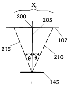
FIG. 2A and FIG. 2B illustrate, in an idealized fashion, several concepts of
the survey described
immediately above pertinent to the present invention. FIG. 2A shows the ray
geometry (dashed) for a particular
offset, Xo, in the case of a dipping reflector, e.g., the dipping event 145,
at the image gather point 200. Also
shown is the normal-incidence (zero-offset) ray 205. The angle of incidence is
defined between the normal
ray 205 and the incident and reflected rays 210, 215 for the particular offset
Xo. The incident angle is equal
for incidence and reflection in accordance with Snell's Law. For simplicity,
FIG. 2A shows a special case
where the acquisition azimuth, defined as the direction.between the source 115
and the receiver 106, is parallel
to structural dip, i.e., the dipping event 145.
This zero acquisition azimuth case shown in FIG. 2A is illustrative and not
necessarily representative.
Acquisition azimuths must be accounted for along with structural dip and
strike. The acquisition azimuth may
be determined by:
using a constant-azimuth assumption;
azimuth vs. offset, based on the normal ray location; or
~ full azimuth binning.
The constant-azimuth assumption is mainly used for marine surveys employing
towed cables. In such
embodiments where there is significant feathering, the dominant azimuth is
extracted as a function of offset for
each normal (zero-offset) ray position. In acquisition geometries where there
is no dominant azimuth, (e.g.,
most land and ocean bottom cable ("OBC") surveys), full azimuth binning may be
employed. This involves
sorting the data into azimuth, as well as offset bins, either before, or as
part of the migration process. The
decision to bin before or after the migration depends on whether the
embodiment operates on the full volume
(amplitude variation of offset, or "AVO"), or a coarse grid (tomography).
Still other suitable techniques known
to the art may be employed.
FIG. 2B shows the desired, calculated ray geometry after application of the
present invention for the
same time (or depth), except with zero dip. The same angle of incidence shown
in FIG. 2A is traced to the
surface 107. The offset transformation to zero dip may now be described. For a
particular event, the angle of
incidence is fixed and the offsets are mapped from the original dipping case
to the corrected zero-dip case. In
the case shown here, the data in the migrated gather at the original offset,
Xo, in FIG. 2A is mapped to a new
offset, X~, as shown in FIG. 2B. Each prestack migrated image gather is
corrected independently and the
mapping is applied to all times (time migration) or depths (depth migration)
and to all original offsets Xo. Table
1 illustrates the mapping. Starting at the shallowest time (or depth), in this
case time T~, incidence angles are
established and rays traced to the surface 107. The original offset Xo
corresponding to the dipping case 145 is
recorded. For the same time TI, rays are traced to the surface 107, with zero
dip (a horizontal event) and the
corrected offsets X~ are recorded. This is done for a series of times (or
depths) until the maximum value of
-4-
CA 02544079 2006-03-02
WO 2004/065987 PCT/US2003/036738
interest is reached. The correction is a movement of the data, starting at
time TI, from the original offset X° to
the corrected offset X~. This is done for all times.
Table 1. Offset Corrections
Tl or
Dl
X X
10 1000 900
m m
20 2000 1800
m m
30 3000 2700
m m
TZ or
DZ
X X
10 1500 1100
m m
20 2500 2200
m m
30 3500 3300
m m
Returning to FIG. 1, as described above, the signals generated by the
receivers 106 are communicated
to the data collection unit 120. More particularly, the seismic receivers 106
communicate the seismic data they
collect to the data collection unit 120 over the wireless link 109 through the
transmitter 108. The data collection
unit 120 collects the seismic data for processing. The data collection unit
120 may process the seismic data
itself, store the seismic data for processing at a later time, transmit
the,seismic data to a remote location for
processing, or some combination of these things. In the illustrated
embodiment, the data collection unit 120
transmits the seismic data to a fixed-base facility 140 via a satellite 145
and the satellite links 150, although this
is not necessary to the practice of the invention. Ultimately, in accordance
with the present invention, ahe data
collected by the seismic receivers 106 is transmitted to a central facility or
location. This central facility may be
a computing and storing center ("CSC"), e.g., the recording truck 110 or the
fixed-base facility 140. Note that
some alternative embodiments may employ multiple data collection systems 120.
The recording truck 105 is equipped with a rack-mounted computing apparatus
300, illustrated in FIG.
3A and FIG. 3B, with which at least a portion of data collection system 120 is
implemented. The computing
apparatus 300 includes a processor 305 communicating with some storage 310
over a bus system 315. The
storage 310 may include a hard disk and/or random access memory ("RAM") and/or
removable storage such as
a floppy magnetic disk 317 and an optical disk 320. The storage 310 is encoded
with a data structure 325
storing the data set acquired as discussed above, an operating system 330,
user interface software 335, and an
application 365. The user interface software 335, in conjunction with a
display 340, implements a user interface
345. The user interface 345 may include peripheral I/O devices such as a key
pad or keyboard 350, a mouse
355, or a joystick 360. The processor 305 runs under the control of the
operating system 330, which may be
practically any operating system known to the art. The application 365 is
invoked by the operating system 330
upon power up, reset, or both, depending on the implementation of the
operating system 330.
-5-
CA 02544079 2006-03-02
WO 2004/065987 PCT/US2003/036738
Returning again to FIG. 1, the geological formation 130 presents a dipping
event 145. As those in the
art having the benefit of this disclosure will appreciate, geological
formations under survey will typically be
much more complex. For instance, multiple reflectors presenting multiple
dipping events 145 may be present.
FIG. 1 omits these additional layers of complexity for the sake of clarity and
so as on to obscure the present
invention. The invention may nevertheless be practiced in the presence of such
complexity.
The seismic data set acquired as discussed above relative to FIG. 1 is stored
in the data structure 325,
shown in FIG. 3B, and includes the effects of the dipping event 145, first
shown in FIG. 1. FIG. 4
conceptually illustrates a two-dimensional image of the acquired seismic data
set, with each vertical line
representing an offset in the recording array 105 between a receive 106 and
seismic source 115. The line 405
represents the interface of the geologic formation 130 that reflects the
seismic signals 125. Note the curve 410
in the line 405 representing the dipping event 145. Note that the offsets are
"original offsets," i.e., measured
and not yet corrected for the dipping event 145.
A prestack migration is then performed on the acquired seismic data to migrate
the acquired seismic
data prior to correct their subsurface locations. The acquired seismic data
set may be migrated in time or in
depth, depending on the particular implementation. Prestack migration
techniques in both the time and depth
domains are well known to the art, and any suitable technique may be employed.
The data in the image gathers
are now in their proper spatial locations, and the reflection from a
particular geologic event is horizontal with
offset. The prestack migration yields flat events with offset, as is shown in
FIG. SA. Note that, in FIG. SB, the
line 405 is straight-a consequence of the flattening. Note also that the
offsets are still "original," i.e.,
uncorrected for the dipping event 145 and still retain information pertaining
to the angle of incidence
The flattened, migrated data may also be analyzed to yield information useful
in determining the actual
angles of incidence for each offset. The images provided by the prestack
migrated data are separately
analyzed, using tools well known in the industry, to yield an estimate of the
strike and dip of the seismic events.
The acquisition geometry is also known, yielding a dominant acquisition
azimuth as discussed above, or each
azimuth volume may be processed separately. Given the reflector structural
orientation, the acquisition
geometry (azimuth), and the migration velocity field, it is possible to
perform ray tracing from the reflector to
the acquisition geometry to yield the angle of incidence for the dipping
events.
The migrated image also allows the dip and strike of the seismic events to be
defined via a separate
analysis step. More particularly, the dip field can be extracted from:
a poststack depth-migrated volume;
~ a set of interpreted horizons; or
a set of patches of common image point ("CIP") gathers.
Theoretically, only the last approach is valid because it maintains the
consistency between the picked event and
the associated dip. However, the two other approaches can be used as an
approximation when the generation of
CIP patches is not affordable or if the data quality become too poor. When the
stack assumption is violated, and
-6-
CA 02544079 2006-03-02
WO 2004/065987 PCT/US2003/036738
the data quality is very poor (near and below a salt body, for instance), the
use of interpreted horizons becomes
the only alternative to estimate the dip field.
It will also typically be desirable to remove other potential sources of
distortion for algorithms that
assume zero structural dip. For example, the migrated data in FIG. 5A, after
prestack time migration, may still
have residual moveout caused by unresolved velocity or anisotropic effects.
These may be removed by
flattening the data along offset using methods well known in the industry such
as non surface-consistent statics.
These steps of preconditioning are very similar to those commonly used prior
to conventional offset-to-angle
conversion mentioned above.
The migrated data is then spatially mapped to correct their respective offsets
while maintaining the
angle of incidence to the dipping event 145. More particularly, a spatial
correction is applied to the migrated
seismic data to place the migrated seismic data with its original offsets to a
corrected offset position for the
same angles of incidence with zero dip. With the information (e.g., the
dipping event 145) extracted from the
migrated data as discussed above, a ray tracing is performed throughout the
acquisition geometry to determine
the angles of incidence for each offset. From the angles of incidence,
corrected offsets can be determined. The
geometry in FIG. 2A may be used to define a correction that maps the original
offsets X° to their zero-dip
equivalent, corrected offset X~ while preserving the angle of incidence . The
strike and dip estimates,
combined with the migration velocity field and the acquisition azimuth, allow
commonly practiced ray-tracing
approaches to reconstruct the (dashed) ray geometry in FIG. 2A. From this
information the angles of incidence
(illustratively shown for just one event) may be calculated for all offsets.
The shift is the difference between X° and X°. Basically, for a
particular time (or depth) a ray. is traced
to the surface from the dipping event while bookkeeping the angle-of incidence
. This is done for a- range of
angles-of incidence spanning from zero to, for example, 70°. This
represents the range that may typically be
encountered in seismic data. With this information, an incidence angle for
each offset may be implied. Note
that this technique may not exactly trace to an offset of interest, and may
instead interpolate the angles between
the offsets traced to the surface. Next, the same ray tracing is performed for
the same time (or depth) for a flat
event (zero dip). The offsets that relate to the same span of angle-of
incidence are book kept. This leads to
Table 1 showing the span of incidence angles and the offsets for the dipping
case and the flat case. The
(horizontal) spatial correction along offset is a shift from X° to X~.
Note that X° is typically larger than X°.
Therefore, the shift is typically towards smaller offsets. Also, the greater
the original offset X°, the larger the
shift. In this regard, it is a dynamic shift, thus the arrows are larger at
greater offsets. The above is performed
at all times (or depths).
FIG. SA illustrates the data from the image gather location shown in FIG. 2A
after prestack time
migration. FIG. SB shows three arrows 505 that indicate the lateral movement
to be applied, as implied by ,
Table 1, for the reflector at Time 1 (or depth Dl). FIG. SC shows the data
after applying the spatial corrections
to the new X~ offset positions.
_7_
CA 02544079 2006-03-02
WO 2004/065987 PCT/US2003/036738
Once the offset transformation has been performed, the data may be used in
conventional zero-dip
assumption techniques, e.g., an offset-to-angle conversion algorithm, as are
commonly employed in the
industry. Note that the data, after the spatial mapping, is still flattened,
as is shown in FIG. SC. As those in the
art having the benefit of this disclosure will appreciate, some processing
techniques do not employ flattened
data. For example, for full waveform inversion, the data must not have a
normal moveout ("NMO") correction
applied. Therefore, the next step would be to apply inverse normal moveout
("INMO") using the zero-dip
travel time solution used the calculation for angle of incidence, as shown in
FIG. 6.
Some portions of the detailed descriptions herein are presented in terms of a
software implemented
process involving symbolic representations of operations on data bits within a
memory in a computing system
or a computing device. These descriptions and representations are the means
used by those in the art to most
effectively convey the substance of their work to others skilled in the art.
The process and operation require
physical manipulations of physical quantities. Usually, though not
necessarily, these quantities take the form of
electrical, magnetic, or optical signals capable of being stored, transferred,
combined, compared, and otherwise
manipulated. It has proven convenient at times, principally for reasons of
common usage, to refer to these
signals as bits, values, elements, symbols, characters, terms, numbers, or the
like.
It should be borne in mind, however, that all of these and similar terms are
to be associated with the
appropriate physical quantities and are merely convenient labels applied to
these quantifies. Unless specifically
stated or otherwise as may be apparent, throughout the present disclosure,
these descriptions refer to the action
and processes of an electronic device, that manipulates and transforms data
represented as physical (electronic,
magnetic, or optical) quantities within some electronic device's storage into
other data similarly represented as
physical quantities within the storage, or in transmission or display devices.
Exemplary of the terms denoting
such a description are, without limitation, the terms "processing,"
"computing," "calculating," "determining,"
"displaying," and the like.
Note also that the software implemented aspects of the invention are typically
encoded on some form
of program storage medium or implemented over some type of transmission
medium. The program storage
medium may be magnetic (e.g., a floppy disk or a hard drive) or optical (e.g.,
a compact disk read only memory,
or "CD ROM"), and may be read only or random access. Similarly, the
transmission medium may be twisted
wire pairs, coaxial cable, optical fiber, or some other suitable transmission
medium known to the art. The
invention is not limited by these aspects of any given implementation.
The particular embodiments disclosed above are illustrative only, as the
invention may be modified
and practiced in different but equivalent manners apparent to those skilled in
the art having the benefit of the
teachings herein. Furthermore, no limitations are intended to the details of
construction or design herein shown,
other than as described in the claims below. It is therefore evident that the
particular embodiments disclosed
above may be altered or modified and all such variations are considered within
the scope and spirit of the
invention. Accordingly, the protection sought herein is as set forth in the
claims below.
_g_