Note: Descriptions are shown in the official language in which they were submitted.
CA 02549537 2006-06-06
F&K 1920-02-O1
- Page 3 -
INTELLIGENT SYSTEM FOR USE IN SUBTERRANEAN DRILLING
APPLICATIONS
This invention is in the field of subterranean (inland and/or offshore)
drilling in, for
example, oil and gas applications. More specifically, the invention relates to
an
optimized and automated method for determining the suitability of a particular
location of
a drilling tool within a well being drilled as a terminus for the drilling of
the well, based
on the automated assessment of one or more sensory data streams.
BACKGROUND
is Subterranean drilling for natural resources such as oil or natural gas is a
complex process.
Getting a well drilled to the appropriate depth, in the appropriate location
and at a
minimum of wasted cost and resources is the objective of drilling service
companies, and
it is against this background that the present invention is conceived.
zo Effectively, the main decision which needs to be made in the placement and
drilling of an
oil or gas well is to find where recoverable oil or gas really is in the earth
and then get the
drilling tool to that location at a minimum of cost and maximum time
efficiency.
Typically before a drilling company would start the drilling of an oil well,
the soils would
be explored using techniques such as seismology, satellite imagery, or other
detection
zs devices which can effectively determine the presence of hydrocarbons in the
soil, etc.
These techniques give a general idea where oil might be located, which for the
sake of
this discussion will be referred to as a predetermined drilling site. A
drilling rig is then
erected at the predetermined drilling site and drilling is commenced with a
view to
getting to the oil or gas deposit.
CA 02549537 2006-06-06
F&K 1920-02-O1
- Page 4 -
Normally and conventionally the rig would drill down to a predetern~ined
logging
location, where the drilling is temporarily stopped and through a logging
process the soils
or terrain surrounding the drilling tool or the well as drilled so far can be
measured and
s data recovered. Samples or data which are collected are then sent to offsite
geologists for
remote assessment. The exploration stage only gives a general idea of the
location of the
oil and it is necessary, through this geological assessment process on an
ongoing basis as
drilling takes place in the conventional method, to continually assess the
proximity of the
drilling tool to an oil or gas location. Once from the remote assessment of
the data it is
ro detemlined that the well has been drilled to an appropriate depth, drilling
can be stopped
and conventional extraction commenced if the well is going to be capable of
extraction or
the well abandoned if it determined at some point the well is not suitable for
economically feasible oil or gas extraction.
rs Predetermined logging depths for a well are determined by geologists in
advance of the
drilling or as drilling is conducted, based on the general data obtained in
advance of
drilling, and/or might be altered based on data obtained during the drilling
process.
Collecting logging data at a shutdown point at a predetermined logging
location is
zo obviously a very expensive approach to be used in the field.
In the remote geology lab, the geologists receive the information from the oil
fields and
then they analyze it and send the results back. As can be seen in the
following Figure,
these labs are receiving continuous information from many oil fields, which
causes
2s delays in the oil drilling operations.
CA 02549537 2006-06-06
F&K 1920-02-O1
- Page 5 -
Oil Field Oil Field
Oil Field Oil Field
Oil Field
OiI Field
Meld
The delays on the oil drilling operations could be hours or days depending on
how much
information the geologists have to process. Also, another factor chat causes
delays in the
s data analysis is the quality of the information that is received by the lab.
Sometimes the
geologists do not get enough accurate information from the oil fields. In
order to make
decisions about the oil wells, the geologists must have sufficient information
about them.
When the geologists consider that there is not enough information, they ask
the crew who
are in the oil fields to get more data from the soils and send it to them. All
these delays
io increase the costs of the operation.
The problem which has been identified, then, with respect to oil drilling
operations which
it is proposed to address with the present invention is the problem of the
excessive time
and costs involved with offsite assessment of geological data and sample
results obtained
rs from particular predetermined drilling depths in a subterranean well as it
is being drilled.
It would be optimal to be able to assess those data and sample results onsite
rather than at
an offsite lab or remote center, since not only would there potentially be a
quicker
turnaround, but also the data from the particular site in question would not
compete for
priority and resources with the data from multiple other sites being handled
by the same
zo remote center.
Oil Field Oii Field Oil Field
CA 02549537 2006-06-06
F&K 1920-02-O1
- Page 6 -
Shutdowns could be shortened or avoided and overall costs of drilling
operations could
be significantly decreased if it were possible to arrive at some type of an
automated
process for the onsite or online assessment of sensory data.
s
SUMMARY OF THE INVENTION
It is the object of the present invention to overcome shortcomings in the
prior art with
respect to the analysis of sensory data pertaining to the drilling of oil and
gas and other
ro subterranean wells.
It is a further object of the present invention to provide a method and
apparatus which can
be used in the on-site analysis of sensory data collected by a sensing or
logging process
with respect to a subterranean well as it is drilled, for the purpose of
assessing the
is propriety of the location of the drilling tool as a beneficial terminus for
the well. By
analyzing logging data or drilling data from sensors used within the well on-
site at the
drilling rig, rather than sending it to a remote geologist or geology lab,
drilling delays and
costs can be minimized.
zo It is the further object of the present invention io provide a system and
apparatus which
can be used on-site for the online assessment of sample or sensory data
obtained as the
logging process proceeds down to a predetermined logging location, wherein the
captured
drilling sensory data are analyzed on an ongoing or streamed basis during
drilling
operations. This would effectively allow for the on-site and real time
assessment of
zs drilling results without requiring a drilling shutdown for the on-site
assessment of the
information in question.
It is contemplated that the present invention could be useful in a number of
different
applications. Firstly, while the applications in which the present invention
can be used
CA 02549537 2006-06-06
F&K 1920-02-O1
- Page 7 -
are referred to herein as "subterranean" drilling applications, the present
invention could
be used in and is intended to encompass both onshore and offshore drilling.
There would
be no major changes required to the method or system of the present invention
in order to
practice the method in an offshore well as compared to an onshore or inland
well, and it
s is contemplated that the use of an on-site and local data capture and
analysis process or
method such as is proposed herein in either in offshore or in inland
application would be
beneficial.
It has been outlined in further detail elsewhere herein that the method and
apparatus of
io the present invention could be used to analyze sensory data with respect to
the. drilling of
the oil well which was being drilled either on a single axis or on a multiple
axis basis.
Specifically, a well which is being drilled straight down or on a vertical
could be
analyzed using the method and apparatus of the present invention, as could a
well which
is being drilled either in a "horizontal" fashion or alternatively on some
type of a multiple
is axis basis. It will be understood that the use of the method of the present
invention in
either a single or multiple axis drilling application is contemplated within
the scope of the
present invention. As long as the drilling sensors which were used were
capable of
capturing, and the drilling database capable of recording, the necessary
coordinates or
information to provide specific location references corresponding to the
various sensory
zo data captured to the drilling database, the number of axes of operation of
the drilling tool
would not matter to the effective operation of the system or invention and
infect the
present invention may be of increased or significant utility in a multiple
axis drilling
application.
zs The invention addresses problems in the prior art by first comprising or
providing a
method of locating a drilling terminus during the drilling of a subterranean
well and a
predetermined drilling site using a drilling tool. The first step of that
method of the
present invention is a data capture step, which comprises during the drilling
of the well
capturing at least one drilling data stream, which comprises sensory drilling
data. from at
CA 02549537 2006-06-06
F&K 1920-02-O1
- Page 8 -
least one drilling sensor within the well, and saving that drilling data with
reference to the
specific location within the well at which such drilling data was captured to
a drilling
database which is resident upon a computer interfaced to the drilling sensor
or sensors in
question. The second step in the method of the present invention is a data
analysis step
s which comprises, using a site computer located at the drilling site and
software thereon
which comprises at least a terminus decision module, assessing the
desirability of specific
locations within the well as drilling termini based upon the comparison of the
location
referenced drilling data with respect to each such specific location contained
within the
drilling database to at least one terminus decision criteria. Using this
method of locating
to a drilling terminus, drilling of the well can be altered based upon the
determination
during the data analysis step that a desired drilling terminus has not yet
been reached, or
else drilling of the well could be stopped based upon the determination during
the data
analysis step of the specific location within the well which has been reached
by the
drilling tool comprises the desired drilling terminus ai which point in time
the well cou ld
rs be terminated, the tools withdrawn and conventional recovery techniques
commenced.
The actual drilling of the well itself might comprise a dependent step in the
process, but
in its broadest sense the method of locating a drilling tern~inus which is
outlined herein is
intended to comprise solely the sensory data capture to a locally hosted
drilling database
zo of at least one sensory data seam related to the geology or characteristics
of a
subterranean well as it is being drilled, and based upon the sensory data
captured in that
regard rendering some determination as to whether or not an appropriate or
desirable
terminus for the well has been reached or not, and providing some type of a
user output
or interface by which that comparison of the results of that comparison can be
action by
zs the drilling equipment or the operators of the drilling equipment of the
subterranean well
in question.
The method of the present invention, insofar as it comprises a data analysis
step and a
data capture step, might have the steps conducted in different orders or at
the same time.
CA 02549537 2006-06-06
F&K 1920-02-O1
- Page 9 -
For example, the data analysis step might, in an "off line" embodiment, take
place after
the completion of the data capture step. This might be a circumstance in which
all of the
sensory data with respect to a particular section of the well was first
captured to a drilling
database and then the terminus decision module software was used to assess all
of that
s data or information at the same time and decide whether or not any of the
specific
locations which that data pertained to comprised a suitable terminus for the
well. In an
"online" embodiment, the data capture step and the data analysis step could
take place
coincidentally, that is to say that the terminus decision module could conduct
an ongoing
assessment of the drilling data as it was captured to the drilling database,
and effectively
to data could be captured at the same time as the data captured to the
database was being
assessed. In the circumstance where the data capture step and the data
analysis step were
taking place coincidentally, it is further contemplated that the data capture
step and the
dais analysis step could take place coincidentally either at the time that the
drilling tool
was in operation within the well, or alternatively in a more conventional
embodiment
is with the drilling tool having been removed from the well, and the drilling
sensor or
sensors being inserted therein in its place.
As outlined elsewhere herein, the method of assessment of the present
invention might
include, at the conclusion of the data. analysis step, displaying the results
thereof with
zo respect to the propriety of certain locations within the well as a terminu
s for the well to
human users by way of a conventional human computer interface such as a
monitor,
printed report or the like. In another embodiment the method might include,
either rather
than a human display or in addition to a human display, sending instructions
to the
drilling equipment by way of a drilling tool control interface based upon the
results or
zs calculations rendered by the terminus decision module.
The drilling database which is used by the method of the present invention
might either
be hosted upon the site computer itself or alternatively upon another computer
located at
the drilling site which was networked or operatively connected to the site
computer so
CA 02549537 2006-06-06
F&K 1920-02-O1
-Page 10-
that the software on the site computer, and specifically the terminus decision
module,
could access the consents of the drilling database.
The method of the present invention further addresses the problems or
limitations in the
s prior art by allowing in certain embodiments for the triggering of the
cessation of drilling
upon the determination by the system and method that the desired drilling
terminus has
been reached. Alternatively in the case where it is determined that the
desired drilling
terminus has not been reached, the drilling can be continued and based upon
the results
determined by the terminus decision module the drilling tool can be adjusted
to shift the
io direction or other settings of that equipment in terms of the ongoing
drilling of the well.
Finally the method might also offer utility insofar as one of the terminus
decision criteria
which might be applied to the determination of whether or not a proper
drilling terminus
has been reached could be to figure out whether or not effectively the well
was not
economically feasible and whether drilling should just be stopped and moved to
a new
is drilling location.
The number of drilling sensors or sensory data streams captured to the
drilling database
in the method of the present invention could be any number. It may be the case
that
sufficient sensory data or information could be captured with the use of a
single sensor or
zo sensor package, or it may alternatively be the case that one or more data
streams may
require the use of one or more sensors. Ii will be understood that all such
variations in
the numbers of both the types of sensory data streams captured or the types of
drilling
data captured to the drilling database as well as to the number and type of
drilling sensors
which could be used in the method of the present invention are contemplated
within the
zs scope hereof.
The number of terminus decision criteria which could be used in the assessment
of
various locations within the well as drilling termini could also vary, as
could the nature of
such terminus decision criteria. Any number of different types of
characteristics or
CA 02549537 2006-06-06
F&K 1920-02-O1
- Page 11 -
categories of information could be used to determine, with respect to the
needs or desires
of a particular company or drilling outfit, whether or not their particular
set of
requirements for the reaching of an optimal drilling terminus had been
reached, and all
such variations in this factor of the method and system of the present
invention are again
s contemplated within the scope hereof.
There are two particular types of terminus decision modules which are
contemplated, and
which go in hand with two different approaches to the selection or definition
of the
terminus decision criteria which might be applied to the drilling data stored
within the
io drilling database. It is contemplated that the method of the present
invention might first
use terminus decision criteria which were fixed formulas which were
preprogrammed and
preset within the site computer or the terminus decision module software, and
the
comparison of location referenced drilling data from the drilling database to
the terminus
decision criteria which were these preset formulas would effectively comprise
a
is calculation of that formula based upon the location referenced drilling
data in question
and comparing the results of that formula to a predefined range of desirable
results to
assess whether or not a particular terminus decision criteria was met by a
particular
location within the well.
io The second type of a terminus decision module which is contemplated, which
goes in
hand with a second approach to the set-up of terminus decision criteria but
which also it
is felt offers a maximum amount of flexibility as well as strength is to
provide a terminus
decision module which is effectively a fuzzy inference system or an "fuzzy
logic" model,
which based upon one or more terminus decision criteria can render
recommendations
zs regarding the propriety of particular specific locations within the well as
desirable drilling
termini based upon the comparison of all of the relevant terminus decision
criteria
applicable to a particular well to all of the drilling data stored within the
drilling database
with respect to each such specific location. While either a fixed formula
method or a
fuzzy logic or fuzzy inference system method to the terminus decision module
is
CA 02549537 2006-06-06
F&K 1920-02-Ol
- Page 12 -
contemplated within the scope of the present invention, attendant changes or
modifications which might be required to optimally implement either type of
the system
will be obvious to one skilled in fhe art and are contemplated to be within
the scope of the
claims outlined herein. The terminus decision criteria, in either a fixed
formula, or a
s fuzzy logic approach, could be stored within a rules database which was
resident within
or accessible to the site computer, which would allow for easy access for
programming
and upkeep.
Beyond the method of the present invention, the invention also deals with
problems in the
io prior art by providing an intelligent system for use in locating a drilling
terminus during
the drilling of a subterranean well at a drilling site with a drilling tool.
The intelligent
system of the present invention has as its components firstly at least one
drilling sensor
for use within the well to capture sensory drilling data with respect to
specific locations
within the well in at least one drilling data stream, and a drilling database
for storage of
~s drilling data measured by the at least one drilling sensor within the well,
said drilling data
being stored with reference to the specific location within the well at which
such drilling
data was captured. The drilling database would be hosted on a computer located
at the
drilling site.
zo The next element of the intelligent system contemplated herein would be an
interface
between the at least one drilling sensor and the computer hosting the drilling
database
which would facilitate the capture of the at least one drilling data stream
containing the
sensory data with respect to locations within the well for storage to the
drilling database.
is Next there would be software operative on a site computer located at the
drilling site
which would comprise at least a terminus decision module which would assess
the
desirability of specific locations within the well as drilling termini based
upon the
comparison of the location reference to drilling data with respect to each
such specific
location contained within the drilling database to at least one terminus
decision criteria.
CA 02549537 2006-06-06
F&K 1920-02-O1
- Page 13 -
Finally a user interface of some type would be operably connected to the site
computer
which would be capable of rendering the results of the assessment of or
desirability of
specific locations within the well which was conducted by the terminus
selection module,
for use in operation of the drilling tool. Using the intelligent system of the
present
s invention, drilling of the well could be altered or stopped based upon the
determination
by the terminus decision module of the propriety of any particular specific
location
within the well as a drilling terminus.
The drilling database might be hosted either on the site computer, or on a
separate
to network computer which was accessible to the site computer.
Again, the user interface contemplated within the system of the present
invention might
either comprise a human interface such as a display or the like, or might also
include
some type of a control interface directly to the drilling tool where the site
computer could
is communicate to the drilling tool based upon calculations with respect to
the data
contained within the drilling database and could provide adjustments or
corrections to the
settings of the drilling tool automatically without human intervention, or at
least
automatically providing them to the drilling equipment for ratification or
acceptance by
the operator of that equipment.
zo
Again the system of the present invention could be practiced in a number of
different
online or off line embodiments. It is contemplated that the system of the
present
invention could be used in association with drilling sensors which could
either be used
within the well in the absence of the drilling tool, or within the well while
the drilling tool
zs was in operation.
Beyond the overall intelligent system of the present invention, there is also
included
within the scope of the present invention a site computer for use in locating
a drilling
terminus during the drilling of a subterranean well at a drilling site with a
drilling tool,
CA 02549537 2006-06-06
F&K 1920-02-O1
-Page 14-
which site computer comprises a sensor interface for the connection of the
site computer
to at least one drilling sensor in the well, a drilling database accessible to
the site
computer and io which drilling data from at least one drilling sensor can be
stored when
received by the site computer via a sensor interface, said drilling data being
stored in the
s drilling database along with location referencing coordinates related to the
specific
location within the well from which the drilling data was measured, as well as
software
comprising a terminus decision module which will assess the desirability of
specific
locations within the well as drilling termini based upon the comparison of the
location
referenced drilling data with respect to each such specific location contained
within the
io drilling database to at least one terminus decision criteria. Finally, this
site computer
would also include a user output capable of rendering the results of the
assessment of
desirability of specific locations conducted by the terminus decision module
to an
external display or interface. The sensor interface on this site computer
might comprise
at least one communications port for connection to at least one drilling
sensor. The user
is output from the site computer could be either an output such as a video
port or the like for
a human display interface, or could be some type of a digital or control
interface or
output at which could transmit instructions or information directly to a
drilling tool via a
drilling tool control interface so that the drilling tool could be operated
automatically or
with guidance from the site computer of the present invention when used in
accordance
io with the method of the present invention.
In the site computer which is contemplated to be within the scope of the
present invention
the terminus decision criteria could be either fixed formulas or alternatively
again a fuzzy
inference system could be used. In the method, system or site computer of the
present
2s invention the terminus decision module could be configured to automatically
select and
apply only the appropriate terminus decision criteria based upon the nature
and number
of drilling sensors from which drilling sensory data is being stored to the
drilling
database. Put another way, the terminus decision module could automatically
recognize
CA 02549537 2006-06-06
F&K 1920-02-O1
- Page 15 -
which terminus decision criteria were relevant to be applied based upon the
type of
sensory data stored to the drilling database.
The site computer is contemplated to be capable of receiving drilling data via
the sensor
s interface for recordal to the drilling database either during the operation
of the terminus
decision module or before the operation of the terminus decision module.
The invention also comprises a computer program which is operative to control
a site
computer for use in locating a drilling terminus during the drilling of a
subterranean well
to in a drilling site with a drilling tool, the computer program effectively
comprising a
terminus decision module in accordance with the remainder of the invention
outlined
elsewhere herein. Specifically the terminus decision module would, when
executed by a
site computer, perform the steps of accessing from a drilling database
accessible to the
site computer location referenced sensory drilling data obtained from sensor
is measurements taken of at least one specific location within the well come
being drilling
data; assessing the desirability of those specific locations within the well
as drilling
termini based upon the comparison of the location referenced drilling data
with respect
each such specific location contained within the drilling database to at least
one terminus
decision criteria, and communicating the final results of that assessment of
the
zo desirability of these at least one specific locations within the well as
drilling termini to a
user interface of the site computer. The drilling of the well again is
contemplated to be
capably altered or stopped based upon the deterzination by this computer
software
terminus decision module of the propriety of any particular specific location
within the
well as a drilling terminus.
zs
In addition to the computer software of the present invention as well as the
overall system
and business method disclosed herein, there is also disclosed an add-on
sensory interface
kit which could be used with a.n existing site computer. Effectively the add-
on sensory
interface unit would allow for the conversion of an existing site computer
into a computer
CA 02549537 2006-06-06
F&K 1920-02-O1
-Page 16-
which could be used in accordance with the software and method of the
remainder of the
present invention. The sensory interface unit would be capable of connection
to one or
more logging tools or drilling sensors to be used down the well and capable of
converting
signals received from those sensors to data which could be communicated to and
stored
s within the drilling database resident upon a computer operatively connected
to the site
computer, or alternatively if the drilling database were a resident within the
site computer
for storage directly therein.
The use of a dedicated computer with the software outlined herein, or
alternatively the
io addition of the sensory interface unit such as is disclosed herein to an
existing computer
such of the existing computer could use a software the present invention are
both
contemplated within the scope era.
There is also disclosed herein a number of samples of the user interface which
could be
is used in conjunction with a fuzzy inference system as the terminus decision
module for
analysis of data obtained from downhole drilling applications. The user
interface in
conjunction with the computer software of the present invention is also
contemplated
within the scope hereof.
zs D1JSCRIPTION OF TII1J DRAWINGS
While the invention is claimed in the concluding portions hereof, preferred
embodiments
are provided in the accompanying detailed description which may be best
understood in
CA 02549537 2006-06-06
F&K 1920-02-O1
-Page 17-
conjunction with the accompanying diagrams where like parts in each of the
several
diagrams are labeled with like numbers, and where:
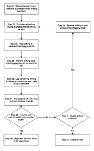
Figure 1 is a process flow diagram demonstrating one embodiment of the prior
art
s analysis method which is used to analyze the propriety of a particular tool
location in a drilling operation;
Figure 2 is a process flow diagram. demonstrating one embodiment of the
process
of the present invention, wherein data are locally analyzed at the drilling
site in an
to offline fashion, during an operations shutdown;
Figure 3 is a process flow diagram of an alternative embodiment of the process
of
the present invention wherein data are locally analyzed at the drilling site
as the
logging tools/sensors are operational and the drilling tool has been removed
from
is the well;
Figure 4 is a process flow diagram of an alternative embodiment of the process
of
the present invention wherein data are locally analyzed at the drilling site
as the
drilling tool is operational;
zo
Figure 5 is a diagram showing one embodiment of the intelligent system of the
present invention, wherein the drilling database is a part of the system of
the
presentinvention;
zs Figure 6 is a diagram showing an alternate embodiment of the intelligent
system
of Figure 5, demonstrating the utility of the present invention in offshore or
underwater drilling applications in addition to the inland drilling
applications
shown in Figure 5;
CA 02549537 2006-06-06
F&K 1920-02-O1
-Page 18 -
Figure 7 is a diagram showing an alternate embodiment of the intelligent
system
of the present invention, wherein the system is interfaced to a separate local
source of sensory data in place of a proprietary drilling database;
s Figure 8 is a block diagram showing one embodiment of a computer system for
use in practice of the intelligent system of the present invention;
Figure 9 demonstrates the data flow in the operation of the computer system
shown in Figure 8;
io
Figure 10 demonstrates the data flow in an alternate embodiment of the
computer
system of the present invention, where the system is integrated with the
control of
the drilling tool;
rs Figure 11 is a block diagram of another embodiment of the computer system
of
the present invenfion, incorporating an external sensory input interface unit
along
with a pre-existing computer;
Figure 12 is a block diagram showing one embodiment of the external sensory
zo input interface unit of Figure 10; and
Figures 13A through 13E are a series of sample embodiments of types of user
feedback or displays that might be generated in accordance with the present
invention.
DETAILED DESCRIPTION OF THE ILLUSTRATED EMBODIMENTS
CA 02549537 2006-06-06
F&K 1920-02-O1
- Page 19 -
Prior art:
Current methods of assessing and determining the proper drilling depth or tool
locations
in oil and gas drilling applications are resource-intensive. Witll a view to
demonstrating
s the shortcomings of the conventional method, as well as framing the backdrop
against
which the present invention can be discussed, the following is a brief
discussion of the
general steps involved in present day oil drilling operations.
Figure 1 is a process flow diagram of the prior art method of logging and
analyzing
to sensory data for oil and gas drilling applications. The first step which is
shown in the
Figure at lA is the exploration step. In the exploration step, a company, by
various prior
art means including seismic assessment or the like, will determine the spot or
spots at
which oil wells should be attempted to be drilled. These are referred to
herein as
predetermined drilling sites.
Shown at Step 1B in Figure 1 is the actual commencement of drilling at one
such
predetermined drilling site. A drilling rig is set up at an subterranean site
and the drilling
tool is used to commence drilling into the earth. While the tools and
demonstrative
Figures shown herein show typical equipment used in inland drilling
applications it is
zo specifically contemplated that the system and method of the present
invention could just
as easily be practiced in offshore drilling applications and any attendant
modifications to
practice the invention in an offshore application would be obvious to one
skilled in the art
and as such are contemplated within the scope of the present invention.
zs Also, while the present application refers generically to using the system
to reach an
optimal 'drilling terminus' it will be understood that the drilling terminus,
in a single-axis
drilling application, would effectively be a desired depth. In a multiple axis
drilling
application such as a horizontal well or a well drilled using a maneuverable
drilling tool,
the drilling terminus to be reached may be a depth but may also include
movement of the
CA 02549537 2006-06-06
F&K 1920-02-O1
- Page 20 -
tool from the initial vertical axis, and that a drilling terlinus which is
just a drilling
depth, or a mufti-axis drilling tem~inus.
The drilling shown at Step 1B would continue until the well reaches a
predetermined
s logging location, shown at Step 1C, which is a depth or location at which
geologists have
determined in advance that drilling should be stopped so that the slate of the
well can be
assessed and the propriety of the drilling terminus or tool location can be
assessed. For
example, the geologists may believe from preliminary exploration results that
there is an
oil-bearing formation 1,200 feet below the surface - the first predetermined
logging
to location might then be at 1,100 feet so that the well can be logged, and
data assessed to
determine the proximity of the tool io an oil-bearing formation or to confirm
the accuracy
of the preliminary projections before the tool is pushed down into the
formation. This is
only one very simple example of the basis on which predetermined logging
depths might
be determined.
The next step in the prior art method is that the drilling tool is removed
from the well and
the logging tools or sensors inserted in the well in their place and lowered
down the
casing or down the well to perform the sensory analysis of the well as drilled
to date.
This is shown at Step 1D in Figure 1.
zo
Step IE shown in Figure 1 is the actual collection of the necessary sensory
data for use
by a geologist or experienced technician in assessing the propriety or
suitability of a
particular drilling tool location as a drilling terminus or for other
purposes. Various types
of data will be gathered and are sent to a geologist located offsite for
review and analysis.
zs The transmission of the necessary samples or data to the offsite geologist
is shown at
Step 1F in Figure 1. Once the data or sample material is received by the
geologist, it is
analyzed to deterline whether or not the well has been drilled to an
appropriate depth or
whether or not further depth needs to be drilled in order to reach an optimal
location, or
alternatively it may also be determined rather than deciding that the well has
reached an
CA 02549537 2006-06-06
F&K 1920-02-O1
- Page 21 -
optimum location, that the well is not going to reach an optimum location at
all and that
the tool should be pulled back, the hole capped and a new well drilled. The
remote data
analysis step is shown at Step 1G of Figure 1.
s The decision to continue with drilling to a new present depth for further
logging and
analysis is shown at Step 1 H in Figure 1 - if it is decided that the well has
reached a good
depth for oil or gas extraction, or a desirable drilling terminus, the tool
can be retracted or
conventional casing and oil or gas extraction techniques commenced (shown at
Step ln.
Alternatively if it is decided that a desirable drilling terminus has not been
reached the
to second decision, shown at Step IJ, would be to decide if the well should be
abandoned.
If the well is determined to be fruitless it may be abandoned in favor of
another
predetermined drilling site (shown at Step 1K). If it is decided that the well
is not yet
optimal but should not be abandoned, effectively a loop back to the resumption
of drilling
to a new predetermined logging depth (Step 1L) where the remote data analysis
can be
is repeated is shown in the remainder of Figure 1. This step would also
comprise the
removal of the logging tools or sensors from the well and reinsertion of the
drilling tool.
As outlined in general above, the shortcomings of this present method are
numerous. The
primary shortcoming which ii is intended to address herein is the fact that
sampling and
zo analysis of the sensory data takes place offsite at a remote geology lab.
Typically, a
drilling company may only employ a small number of geologists compared to the
number
of wells they may be drilling at one time and, as such, it makes the most
sense in that
model for the geologists to work in a central site. However, as outlined
above, the use of
a model such as this where the data obtained from the drilling installation is
transmitted
zs to a remote site for analysis by a geologist is more costly, both in terms
of the capital
infrastructure required at the drilling site as well as in terms of the lost
money or added
costs associated with indeterminate or lengthened shutdown periods while the
data is
analyzed. For example, where the data is to be transmitted electronically to
the geology
site, it is necessary for the oil rig to be equipped with satellite or other
means of
CA 02549537 2006-06-06
F&K 1920-02-O1
- Page 22 -
communication by which electronic data can be transmitted or received back
from the
geology lab. In addition to the requirement for satellite transmission or
receiving
equipment at the drilling site, it is also necessary to have corresponding
communications
infrastructure in place in the central geology lab. Alternatively, in a
situation where the
s logging data were not to be transmitted electronically, but rather
physically delivered to a
centralized geology site, the time and cost associated with the transport of
that
information also renders the present day method impracfical.
The second major cost associated with the present day method of analyzing oil
well
to drilling activity is the time and. cost associated with the use of an
actual geologist in the
assessment of the propriety of a particular drilling terminus. Not only is it
costly to
employ a geologist, and it makes sense in most cases to employ them at a
remote site
given the number of wells they would be responsible for monitoring at all
kinds of
different scattered sites, but as long as the data are being analyzed by one
or more
is geologists either onsite or at a remote site the shutdown periods at the
rig are longer and
more costly than if some more automated method of monitoring andlor reviewing
the
logging data from the well could be come up wish. For example, it may be the
case that
when the sample data from a particular well drilling site is transmitted to
the geology
center they are already working on data. for numerous other sites and, as
such, the
zo shutdown could take anywhere from a shorter period of a couple of hours
through to a
number of days. During this entire time, the rig sits idle with labor costs
continuing to
run, and the opportunity cost of moving the rig on to a new site sooner are
also
continuing to rise.
zs By drilling to predetermined logging depths, the drillers can never reach
with a specific
degree of precision the exact location of the oil or gas in question, based
solely on the use
of exploration data obtained in advance of the drilling of a hole. For
example, drilling
down to predetermined logging depths may cause undershoots or overshoots. An
undershoot would be known in the industry as when the drilling is done to a
CA 02549537 2006-06-06
F&K 1920-02-O1
- Page 23 -
predetermined depth which is above where the oil is located. On the contrary,
an
overshoot would be a situation in which the drilling is continued either into
or through
the oil deposit to the point that the oil deposit is left behind as the hole
continues
downward. Neither of these results is optimal, obviously, and results in
imprecise ability
s to drill to the right location.
General method overview:
There is disclosed a method for the assessment of the propriety of a drilling
terminus or
io drilling site in a subterranean drilling application. The method
effectively comprises
capturing one or more sensory data streams from a well being drilled, and
applying a
computer implemented formula or fuzzy inference system to those data to
provide to the
operator of the drilling equipment recommendations and instructions as to
whether or not
the drilling tool has reached an appropriate drilling terminus ai which the
well could be
is terminated and/or alternatively if drilling should be continued in the same
or another
direction. For companies that use conventional well logging tools the system
would help
them to analyze the data in the oil fields, but it will not necessarily be in
real time.
Conventional well logging tools are the ones that cannot conduct the logging
process
while drilling is being done. In this case, oil companies drill to a
predetermined depth,
zo take the drilling tools out of the well and then introduce the drilling
sensors or other tools
for the logging process. This means that the analysis of the data has to wait
until the
logging tools are reintroduced into the oil well.
Once the sensory data were captured from the sensors, they could be analyzed
by the
zs system of the present invention to determine the propriety of various
locations within the
well as drilled so far as a drilling terminus and drilling operations could
either then be
resumed based on feedback or instructions provided by the intelligent system
of the
present invention or alternatively drilling could be terminated for either
positive or
CA 02549537 2006-06-06
F&K 1920-0Z-O1
- Page 24 -
negative economic reasons, i.e. that either the appropriate depth had been
reached from
which to extract oil or gas from the well, or alternatively it had been
determined either by
the system itself or the system had advised the operator of the drilling
equipment, who
confirmed the decision, that the abandonment of the well was an appropriate
option for
s consideration.
In an offfine embodiment, the sensory data streams described herein would be
captured in
a drilling database accessible to the site computer in which the software of
the present
invention is operated, during a drilling shutdown at the drilling site. In
another
io embodiment, the method of the present invention could be used in a system
where the
drilling tool was removed from the well to insert the drilling sensors or
tools, while the
well was being logged (i.e. rather than during a drilling/logging shutdown).
The sensory
data stream or streams would be captured in a drilling database accessible to
the site
computer in which the software of the present invention is resident during a
drilling
is shutdown at the drilling site. Once the data. were captured from the
sensors, they could
be analyzed in real time by the system of the present invention.
Some companies have been exploring new technologies that allow them to capture
drilling sensory data while they are drilling. These companies have developed
drilling
zo sensors that are able to resist the tough conditions present during the
drilling process.
This means that with the intelligent system of the present invention these oil
companies
would be able to analyze the drilling sensory data. in real time while the
drilling process is
being done. In this scenario oil companies would not need to drill to
predetermined
depths to take sensor readings, minimizing undershoots or overshoots.
In one online embodiment of the method of the present invention, the sensory
data
streams described herein could be captured on an ongoing basis from sensors
present in
the well as drilling operations continue. The sensory data is fed back to a
drilling
database which is again accessible to the computer involved in the execution
of the
CA 02549537 2006-06-06
F&K 1920-02-O1
-Page25-
terminus decision module software component and the remainder of the method of
the
present invention. When the temvnus decision module software of the method of
the
present invention determines that a desirable drilling terminus had been
reached, drilling
operations could be ceased. Alternatively, if the terminus decision module
determined
s that a drilling terminus had not yet been reached from which extraction was
optimal
and/or that the situation did not at this point yet warrant abandonment of the
well, the
terminus decision module, in the next step of the method, could display to the
user of the
system the feedback used to continue drilling which might either include
simply an
indication that drilling should continue or alternatively may also include
further
to information regarding either the analysis applied to the sensory data
and/or alternatively
the directions regarding realignment or movement of the drilling tool in
multiple axis
drilling applications.
Effectively then it is contemplated that there are three different
circumstances or
is workflows in which the method of the present invention could be employed.
The first of
these would be to analyze the sensor data during a complete equipment
shutdown. The
second circumstance would be to analyze the sensory data during the logging of
a well
(i.e. while the drilling tool is removed and logging or sensor tools are
inserted into and
being moved down the well). Finally, in cases where logging or sensing can be
done
zo while drilling, the present invention could be practiced during drilling.
The apparatus and method of the present invention could be useful in a number
of
different applications. Firstly, while the applications in which the present
invention can
be used are referred to herein as "subterranean" drilling applications, it
will be
zs understood that this is intended to encompass both onshore and offshore
drilling.
Specifically, there would be no major changes to the method or system of the
present
invention which would be required in order to practice the method in an
offshore well as
compared to an onshore or inland well, and it is contemplated that the use of
an onsite
CA 02549537 2006-06-06
F&K 1920-02-O1
- Page 26 -
and local logging of data analysis method such as is proposed herein in either
an offshore
or an inland application is contemplated within the scope of the present
invention.
Figures 2, 3 and 4 are provided to demonstrate the general flow of the three
main
s contemplated embodiments of the present invention, from which variants to
accomplish
various specific objeciiveswf~rwiudi~ininal--wella-wauwlxwc~ut~empiatezU-aud-
wwiliwbG-w
understood to be contemplated within the scope of the present invention.
Figure 2 is a process flow diagram showing the method of local automatic
intelligent
io assessment of well log data in an offline fashion - i.e. a drilling
shutdown could still take
place while the data were assessed. In terms of commencing drilling of a well
in
accordance with the method of the present invention, the preparatory steps
would be the
same as those conducted at the present time for other conventional drilling.
Shown at
Step 2A is the exploration step, wherein one or more predetermined drilling
sites would
is be selected based upon exploratory geological work. That type of
exploration work is
often done using equipment and technology such as seismology, magnetometers or
gravity meters, as outlined in furkher detail above. These are just a few of
the types of
exploration techniques which can be used to determine the initial point at
which it might
be desired to try to drill a well. The uncertainty associated with the early
exploration
zo results, however, forces geologists to confirm the results regarding
location of the oil or
gas which is sought during subsequent phases of the oil drilling process. The
initial
stages of a drilling operation, including exploration and location of the
drilling locations
to be used, will be understood by one skilled in the art to not be
contemplated within the
scope of the present invention in a limiting scope. Those steps are shown
within the
zs Figures of this patent to give a full understanding of how the system of
the present
invention might integrate with the well drilling process, but it will be
understood by one
skilled in the art upon consideration of the remainder of this specification
that the method
of the present invention is specifically directed towards the use of the
terminus decision
module software combined with a local instrumentation package and a local site
CA 02549537 2006-06-06
F&K 1920-02-O1
- Page 27 -
computer to advise the operator of a drilling tool upon the propriety of a
particular point
reached in the drilling of the well as a drilling terminus, or alternatively
to directly
control the drilling tool. As such it will be understood that the
demonstration of the
selection of predetermined drilling locations, while considered useful by the
inventors for
s the sake of demonstration of the technical problem addressed by the present
invention, is
not an essential element to be included within the claims of the present
patent application.
Once a predetermined drilling site is decided or selected, the drilling rig
can be set up and
drilling can be commenced. Drilling commencement is shown at Step 2B in Figure
2.
to The drilling rig typically would first drill down to a first logging
location which was
previously selected based on the earlier exploration data obtained. In this
particular
embodiment of the method of the present invention, this prior art method of
drilling to a
particular predetermined logging location ai which point in time the logging
sensor or
tools can be inserted into the well is accommodated.
Once a predetermined logging location is reached, shown at Step 2C, the
removal of the
drilling tools and insertion of logging tools or sensors into the well is
shown in Figure
2D. Next, sensory data are captured with respect to the well or hole as
drilled so far. This
may consist of various types of drilling sensors or sampling taking place
within the well,
zo at or near the drilling tool. Many conventional or prior art sensing or
logging methods
might be used, modified only to the extent that the readouts or data from
those sensors
will be captured locally at the drilling site to a drilling database for use
by the intelligent
system of the present invention. Capture of drilling sensor data to a drilling
database is
shown at Step 2E in Figure 2.
zs
In addition to the actual sensory data from the drilling sensors within the
well, the drilling
data contained within or stored to the drilling database could include
reference or
indication of the location within the well at which each such sensory reading
was
captured. In a circumstance where the method of the present invention was
being used to
CA 02549537 2006-06-06
F&K 1920-02-O1
-Page 28 -
effectively "sample" readings at various locations within the well, rasher
than to simply
assess the drilling data with respect to particular location in the well by
lowering the
drilling sensors to that location and taking readings from their upon which
assessment
can be taken on the surface, it will be necessary for the drilling database to
in some
s fashion know where the location is within the well at which each sensor
reading was
taken so that sensor readings from various sensory data streams can all be
compared in
respect of the same location within the well, as well as so that the sampling
or assessment
of the sensory data with respect to multiple locations within the well as
drilled so far can
be conducted at the same time or in serial fashion.
io
The intelligent system of the present invention is a computer hardware and
software
system capable of analyzing the sensory data captured in the drilling database
to provide
drilling feedback or recommendations to the rig operators. Specifically it is
contemplated
that a terminus decision module consisting of some type of fuzzy inference or
'fuzzy
is logic' system or computer based formula might be used to determine an
optimal drilling
terminus or the presence or absence of recoverable oil or gas at a particular
location in a
well based on the analysis or blending or combination of the various sensory
data stored
within the drilling database with respect to that particular location.
Analysis of the
sensory data captured to the drilling database up to the predetermined logging
location in
zo the well by the intelligent system, and more specifically by the terminus
decision module
in conjunction with the remainder of the components of the system, in the
method shown
in Figure 2 is shown at Step 2F.
Whether the terminus decision module employs a fuzzy inference or a computer
based
zs formula system in analysis of the sensory data contained within the
drilling database, the
terminus decision module at Step 2F will determine if the well has been
drilled to a
satisfactory location or depth for oil or gas extraction or, in reference to
the terminology
used in the remainder here of, whether or not a satisfactory or desirable
drilling terminus
has been reached. If it is determined by the intelligent system on the basis
of the sensory
CA 02549537 2006-06-06
F&K 1920-02-01
- Page 29 -
data contained within the drilling database that an optimal drilling terminus
has been
reached - either at the terminus of the well as it stands, at the tool face,
or at a point up
the well (i.e. if the optimal location has been overshot) - then the operator
of the rig can
be notified by the intelligent system through a conventional user interface
and the regular
s process of tool recovery/casing/extraciion can begin.
Alternatively, if the terminus decision module of the intelligent system
determines that an
optimal drilling terminus has not yet been reached, and if the terminus
decision module
determines that the well is not a candidate for abandonment - i.e. so long as
the system
io determines that the well should not be abandoned or the operator decides
not to abandon
the well based on infom~ation or feedback from the intelligent system - then
drilling
could be recommenced to a next predetermined logging location, where new
drilling
sensory readings could be taken and a new assessment repeated in terms of
assessing the
feasibility of the well and whether or not an optimal drilling terminus has
yet been
is reached. This is shown at Step 2J, looping back to another drilling
stoppage at 2C. If the
terminus decision module determined, or the operator decided, based on the
data obtained
from the well, that the well should be abandoned (shown at 2I) appropriate
shutdown
steps could be taken and the rig moved to a new drilling site.
zo By using a computerized intelligent system in accordance with the present
invention
which is capable of collecting and analyzing the drilling data with respect to
a well from
the drilling database as outlined herein with a ternzinus decision module, the
various
types of sensory data can be accumulated and assessed onsite and it can be
decided, in
accordance with a predetermined matrix or formula within the system, whether
or not a
zs desirable drilling terminus has been reached, or alternatively whether
drilling needs to go
deeper or further, or if a particular location is just not good for further
drilling in which
case the drilling can be abandoned and a new site started.
CA 02549537 2006-06-06
F&K 1920-02-O1
-Page 30-
By assessing the drilling data captured by a drilling sensor and stored to a
sensory
database for the well onsite rather than at a remote site, the need for
satellite or other
communications equipment at the drilling rig for this purpose is eliminated.
This can
result in a significant cost reduction. As well, by assessing the data locally
rather than
s remotely it is likely that shutdown times between drilling sessions in
instances where the
method outlined in Figure 2 is practiced can be minimized. The second option,
however,
which is submitted will enhance completion times and profitability in drilling
operations,
beyond simply analyzing the data locally rather than remotely as in the
embodiment
shown in Figure 2, is the addition of an online aspect to the system wherein
if the
to intelligent system of the present invention incorporates software and
hardware which is
capable of capturing and analyzing various drilling sensor data captured in
the drilling
database with respect to the well in automated fashion during drilling, then
the need for
drilling shutdowns could even be avoided and the system could monitor data and
provide
the necessary corrections or adjustments to the drilling process as might be
required on a
is ongoing and online basis.
The embodiment of Figure 2 demonstrates both the preparatory steps to the
selection of a
drilling site, through to the location of the drilling tool and commencement
of drilling, as
well as the following steps after the determination that an appropriate
drilling terminus
io has been reached - namely the recovery of the drilling tool and either the
closure or
commercial exploitation of the well. The primary aspects of the method of the
present
invention however relate to the sampling of data with respect to the well as
it is drilled
and the assessment of that data on an ongoing basis against a predetermined or
fuzzy
inference model to determine based on the data. captured to a drilling
database whether or
is not an appropriate drilling terminus had been reached. Insofar as the
sampling and
assessment of the sensory data with respect to the well as it is drilled are
the primary
aspects of the invention it will be understood that the preparatory steps, as
well as the
following steps upon determination of the reaching of a good drilling terminus
are
CA 02549537 2006-06-06
F&K 1920-02-O1
- Page 31 -
dependent upon these preparatory steps and on that basis or not contemplated
to be within
the broadest scope of the claimed invention.
Referring next to Figure 3, there is shown a process flow diagram of an
alternate
s embodiment of the present invention which is effectively a method by which
the drilling
sensor data captured from within a drilled well can be captured to a drilling
database and
analyzed in real time by an intelligent system to advise the operator of the
drilling rig as
to the appropriate action to be taken with respect to movement of the drilling
tool, or at
such point in time as an appropriate drilling terminus is reached. The method
of Figure 3
io as outlined above can operate in an effectively "online" fashion whereby it
would operate
during the logging of the well and no logging shutdown would be contemplated
within
the scope of the method disclosed in Figure 3. This is different from the
method which
will next be disclosed in Figure 4, which contemplates actual realtime
analysis of drilling
sensory data from within the well during drilling, where drilling sensors (7)
which can be
is used while drilling is taking place are contemplated to be used.
Where the application herein refers to "logging" of the well or "logging
tools", logging is
a term of art within the drilling industry which refers to the sensory
assessment and
capture of sensory data with respect to the characteristics of the well. The
logging of a
zo well effectively typically comprises a lowering one or more logging tools
or sensor
packages down the well which can as they are lowered to take sensor readings
of various
characteristics of the geology or of the well. For the sake of the contents of
this
application in the understanding of the present invention, where we refer
herein to
"drilling sensors" or the capture of drilling sensory data with respect to a
well, the
zs translation of this into the lexicon of "logging" would result in the
equivalent reading of
"drilling sensors" to also mean "logging tools or sensors" as those might be
understood
by one skilled in the art.
CA 02549537 2006-06-06
F8cK 1920-02-O1
- Page 32 -
The first number of steps of the method shown in Figure 3 are similar io that
of the
method shown in Figure 2. Shown at Steps 3A and 3B are the commencement of
drilling
at a particular predetermined drilling site.
s Once a particular predetermined logging location was reached during the
drilling of the
well, the drilling tool would be removed from the well and the drilling
sensors (7) would
be inserted into the well a.nd'provide the necessary sensory data with respect
to the well
as drilled to date. This is shown at Step 3C in Figure 3. In terms of the
number of
drilling sensors which could be used in any embodiment of the method of the
present
io invention it will be understood that the minimum number of sensors or
sensor packages
which might be used would be one, but there may in fact be more than one
sensor or
sensor package used within the well to capture one or more types of sensory
data with
respect to the well and that any number of drilling sensors or combines sensor
packages
which might desirably be used by someone practicing this invention is
contemplated
is within the scope hereof.
Shown next at Step 3D in Figure 3 is the local capture of the sensory input or
sensory
data from the sensors or tools lowered down the well for that purpose to a
drilling
database. In the practice of the method of the present invention, the analysis
of the
zo logging data captured to the drilling database could take place as the data
were being
recorded to the database. Specifically, on an ongoing basis as the data were
being
captured as shown in Step 3B, the terminus decision module could analyze the
sensory
data being captured in real time and provide feedback or indications to the
operator in an
ongoing loop, and it is contemplated then that effectively as additional
sensory data were
zs captured that they would also be similarly analyzed from the drilling
database, and
ongoing feedback prepared and displayed or made accessible to the operator in
some
fashion. The sensory data which was stored to the drilling database would in
some
fashion need to reference the location within the well from which that
particular piece of
data was captured. This is necessary both where more than one data stream or
more than
CA 02549537 2006-06-06
F&K 1920-02-O1
- Page 33 -
one sensor was used in order to be able to compare all of the sensory data
from a similar
location within the well at the same time, and also to be able to conduct an
ongoing
assessment of the sensory data from the drilling database where a "sampling"
effect was
created by the conduct of a continuous assessment loop of the type outlined
herein.
s
Shown next at Step 3E in Figure 3 is a decision by the terminus decision
module which
would be a part of the ongoing analysis of the data in real time from the
drilling database
as it is captured, namely whether or not the logging tool has reached a
satisfactory
location or depth within the well, which would imply that the drilling tool
has also
io reached a similar location and that location may be a satisfactory drilling
terminus for the
well.
There is shown at Step 3F in Figure 3 a determination in that decision block
that a
location from which profitable oil or gas recovery could be made had been
reached i.e. a
is beneficial or satisfactory drilling terminus had been reached.
Alternatively, if the Step 3F
decision block is determined in a negative fashion (i.e. that the particular
location to
which a particular set of sensory data corresponds is not a satisfactory
drilling terminus
for profitable recovery) another decision block, which is shown at Step 3G, is
to
determine whether or not drilling should continue. If it is determined by the
terminus
zo decision module andlor the operator that drilling should not continue and
that a well
should be abandoned since there would not appear to be any zone for profitable
recovery,
that is shown at Step 3H in Figure 3.
Shown at Step 3I in Figure 3 is another decision block which pertains to the
zs determination of whether or not logging or the capture of sensory data from
the sensors
down the well should continue, or alternatively whelher drilling should be
recommenced.
If it were determined that logging should continue and the drilling sensor or
sensors
should be continued to be lowered down the well as drilled, this is shown as
the "yes" leg
of the decision coming off Step 3I in Figure 3, effectively completing the
analysis loop
CA 02549537 2006-06-06
F&K 1920-02-O1
-Page 34-
back to Step 3D which would mean that logging tools or sensors would continue
to be
lowered down the well or would continue to be used to capture additional data
for
additional analysis by the system of the present invention.
s Alternatively, if it were determined at Step 3I in the decision process
shown in Figure 3
that logging should not continue and that drilling should be resumed, then the
"no" leg of
the decision block shown at Step 3I shows that the operator could be advised
by the
system or in accordance with the business method of the present invention in
some
fashion the drilling tool could be reinserted into the well. The drilling tool
being
io reinserted into the well is shown at Step 3J in Figure 3. The system could
also provide
analysis or advice to the operator as to whether or not any adjustments or
realignment
should be made to the drilling tool and this is shown also as a part of Step
3J.
Effectively, Step 3J in Figure 3 shows the reinsertion of the drilling tool as
well as a
determination of whether or not the tool should be redirected. Shown as the
"yes" block
is of the Step 3J decision is the communication of new drilling alignment or
tool
redirection, shown at Step 3K. Alternatively, if it were determined at Step 3J
after
reinserting the drilling tool that no drilling realignment or redirection were
required then
simply following the "no" leg of that decision block back to Step 3B, it can
be seen that
the drilling tool upon its reinsertion would recommence or continue drilling
io another
zo predetermined drilling terniinus, at which point in time the method of
Figure 3 could be
repeated, that is to say that the drilling tool could again be removed, the
sensors placed in
the well and the sensing or logging process recommenced.
Referring next to Figure 4, there is shown a process flow diagram of an
alternate
zs embodiment of the method of the present invention which is effectively a
method by
which the drilling sensor data captured from within a drilled well can be
captured to a
drilling database and analyzed in real time by the intelligent system to
advise the
operators of the drilling tool as to the appropriate action to be taken with
respect
movement of the tool, or at such point in time as an appropriate drilling
terminus is
CA 02549537 2006-06-06
F&K 1920-02-O1
- Page 35 -
reached, the method of Figure 4 as outlined would operate in effectively an
"online"
fashion whereby no drilling shutdowns are contemplated within the scope of the
method
disclosed therein.
s The first number of steps of the method shown in Figure 4 are similar to
that of the
method shown in Figure 2. For example, preliminary selection of one or more
predetermined drilling locations is made based on initial exploration work,
shown at Step
4A. Shown at 4B is the commencement of drilling at a particular predetermined
drilling
location. It is contemplated that the drilling apparatus used in the practice
of the method
io of Figure 4 would be properly instrumented such that the necessary or
required drilling
sensor data which the particular driller felt was necessary to properly assess
the propriety
or nature of a particular drilling terminus would all be capable of being
captured to a
drilling database during the drillW g Uf 1hG WGlI by ~IIG add111VI1 Uf 1hC
IlCI:eSSary dIllhllg
sensors or instrumentation to the drilling equipment used in the drilling
shown at Step
is 4B. The actual capture of sensory data io a drilling database for real time
analysis by the
terminus decision module of the present invention is shown at Step 4C. as
outlined
elsewhere herein the drilling database in addition to containing the actual
sensory
information or readings captured within the well might also reference the
specific
locations at which particular pieces of sensory data contained within the
drilling database
zo were captured within the well. In this type of a embodiment of the method
of the present
invention however, where the analysis of the sensory data was being conducted
on a real-
time basis during the drilling of the well, it may not be so necessary to have
a lot of
additional location reference or coordinates stored to the drilling database
provided that
the sensor readings themselves were being taken at a location in the well
close enough to
zs the drilling tool that effectively by conducting the data analysis step of
the method of the
present invention on an ongoing basis and in a rapid enough fashion, the
drilling tool
would effectively still be at the location from which the sensory data in
question were
captured when the analysis of that particular data was completed by the
intelligent system
of the present invention. In that particular case the "location reference" of
the specific
CA 02549537 2006-06-06
F&K 1920-02-O1
- Page 36 -
sensory data being analyzed by the intelligent system of the present invention
may simply
be the present location of the drilling tool, or some particular precalculated
offset location
in the circumstance where the sensor or sensors were located in the well in a
fixed or
already known location ahead of or behind the drilling tool.
By using a drilling apparatus which is instrumented for the online capture of
drilling
sensor data with respect to the well, it is possible to have the intelligent
system of the
present invention analyze in real time the drilling sensor data as it is
captured to the
drilling database and while drilling operations continue. This would allow for
the
io intelligent system to assess the nature and location of the well and the
present terminus of
the well below the surface without requiring drilling shutdowns. This could
have
numerous benefits, particularly in the instances where multi-axis drilling is
to be carried
out, since if drilling were continuing and the data were being captured and
assessed in an
online fashion, ongoing adjustments to the direction and alignment of the
drilling tool
is could be made as necessary.
In any event, Step 4D in Figure 4 shows a decision block which effectively
represents the
analysis to be conducted by the intelligent system of the present invention on
an ongoing
basis of the sensory data being captured to the drilling database.
Effectively, the decision
zo which is shown at Step 4D is a decision as to whether or not an appropriate
and
satisfactory drilling terminus has been reached, or effectively if there is
profitable oil and
gas at the particular location in question, on the basis of which drilling of
the particular
well could be ceased. If an appropriate depth has been reached, either at the
drilling
terminus or at some point which is determined to exist back up the hole from
the drilling
zs tool (again, in the situation effectively of an overshoot), drilling
activity can be ceased
and the conventional recovery of the drilling tool and extraction of oil or
gas from the
well can be commenced, as shown at Step 4E. Alternatively, if it is determined
that the
tool has not reached a satisfactory location from which oil or gas can be
recovered, one
would look at the second leg of the decision block shown at Step 4D in Figure
4.
CA 02549537 2006-06-06
F&K 1920-02-O1
- Page 37 -
Basically, if the appropriate location has not been reached, the next decision
which could
be undertaken by the intelligent system of the present invention using the
terminus
decision module (again in accordance with whatever fuzzy inference system or
otherwise
programmed computer-implemented formula as an analysis tool is contained
therein for
s the weighting or analysis of this sensor data capture to the drilling
database) is that of
whether or not drilling should continue. This is shown at Step 4F in Figure 4.
If it is determined, for example, that it is a "dry hole" or that the well is
otherwise not
economically feasible or the like and that it should be abandoned, Step 4G in
Figure 4
to simply indicates how the equipment could be extracted and the well
abandoned.
Alternatively, however, the second leg of that decision shown at Step 4F in
Figure 4 is
that if the determination is made that drilling should continue, then the
operator of the rig
could be advised in an ongoing fashion by some type of human interface or
alternatively
otherwise the drilling of the well could continue with the capture of sensory
data and
is analysis thereof by the intelligent system shown in Steps 4C through 4F and
4J
continuing in a loop fashion until either an appropriate drilling terminus was
reached or
alternatively a determination was made to cease drilling and abandon the well.
Where we refer to the "drilling terminus" within this document, what is
intended or
zo referred to is a particular subterranean location in the drilling of the
well. In the drilling
of a well in a single axis i.e. vertical, a particular drilling location below
the surface
would effectively be at a depth only and so a particular drilling terminus
would be a
particular drilling depth. In a drilling application where multiple axes of
movement were
capable or possible with the drilling tool however, or in a horizontal
drilling application,
zs a particular drilling terminus may be at coordinates other than simply a
depth below the
surface and it will be understood that in any event the use of the term
"drilling terminus"
is used to refer to any subterranean location which is the end of a well as
drilled. A
"satisfactory" or desirable drilling terminus might be the termination of a
particular well
at which point it was determined that there was economically feasible oil or
gas to be
CA 02549537 2006-06-06
F&K 1920-02-O1
- Page 38 -
recovered, but there will also be circumstances in which a well is capped or
abandoned
and the bottom and/or extreme end of that well would still constitute a
drilling terminus
as well.
s Also shown at Steps 4H and 4I in Figure 4 is a further extension of the
methodology of
the present invenfion. Effectively, it is contemplated that using the
intelligent system of
the present invention in direct communication with the drilling equipment
itself, or by at
the very least provision of additional user interface information to an
operator, it can be
contemplated that the intelligent system could, beyond advising of the
propriety of a
to particular drilling terminus which has been reached, also provide to the
operator or
directly to the instrumenia3ion of the drilling rig specific instructions or
feedback
regarding any adjustments which might be made to optimize the drilling process
with
respect to the well. It is particularly contemplated that in the case of
horizontal or multi-
axis drilling, it may be possible using a fuzzy inference system such as is
contemplated
is within the scope of the present invention as the terminus decision module
to predict the
proper alignment of a tool to reach on a multiple axis basis a desired
location or drilling
terminu s.
As shown at Step 4H in Figure 4, if it were determined by the intelligent
system that the
zo drilling tool should be redirected or realigned in some fashion before
continuing drilling,
that new drilling alignment could be communicated either directly to the
drilling
equipment or to the operators of the drilling equipment and the tool could be
redirected as
the drilling is continued at Step 4J and looping back again to the continued
capture and
analysis of sensory data from the well as is shown in the remainder of Figure
4. It is
zs contemplated that this additional aspect of the invention could add further
utility in
horizontal and multi-axis drilling applications.
The general processes shown in Figures 2, 3 and 4 demonstrate only certain
embodiments
of the decision process contemplated within the scope of the present
invention. For
CA 02549537 2006-06-06
F&K 1920-02-O1
- Page 39 -
example, the particular characterization of the decisions being made by the
terminus
decision module of the present invention in advising the operator or carrying
out actions
based on the sensory data captured to the drilling database may be
characterized in any
number of different ways and all of which are contemplated within the scope of
the
s present invention. That is to say that the rules or the formulas applied to
the data
captured to the drilling database by the remainder of the system of the
present invention
could incorporate significant additional steps or significant additional
detail or minutia in
a decision making process or additional decisions or decision trees could be
added to the
rzpnPral data flncv and rrnnPee flrnv ehrnvn in ihP fi~nmPe of fho hrPeanf
Annnmant,_nn~i ?11 ..._ . __ .. _
to such changes which would still not depart from the general concept of the
use of an
onsite local intelligent system to provide either in a realtime or rapid
fashion, without
communication to an offsite geologist, advice to an operator of a drilling
unit whether or
not they should conduct further drilling or sensing with respect to a well are
all
contemplated within the scope of the present invention.
System components:
To review now briefly the major components of the system of the present
invention
which are used to practice the method disclosed herein, we refer to Figures 5,
6 and 7.
zo Figure 5 demonstrates one embodiment of the system of the present invention
implemented in a vertical drilling application. There is shown the intelligent
system (1)
of the present invention, which includes a drilling tool (S) and its related
equipment (4),
The well itself which is being drilled is shown at (16).
zs There are also included one or more logging instruments or drilling sensors
(7) which are
capable of capturing different information with respect to the well itself or
the
characteristics of the surrounding geology of the well (16) as drilled. In
this particular
case, three sensors (7) are shown. It is contemplated that the system (I) of
the present
CA 02549537 2006-06-06
F8cK L920-02-O1
-Page40-
invention could either be used in an offline fashion, wherein the sensors (7)
would be
potentially lowered down the well (16) for the purpose of measuring or
assessing the
various formations or characteristics associated with the well during a
drilling shutdown,
or alternatively the system (1) of the present invention could be used in an
online fashion,
s wherein the drilling sensors (7) could be attached to the drill stem or
extended down the
well (16) in some other fashion during drilling operations, continuously
feeding data back
to the remainder of the system (1). The use of the system (1) of the present
invention in
either such an offline or online fashion is contemplated within the scope of
the present
invention.
io
The drilling tool (5) itself is shown retracted from the well (16) in this
case - presumably
this shows a sensor (7) array being used down the shaft during a drilling
shutdown, but it
will be understood that showing the tool (5) in a withdrawn position from the
well (16)
while the sensors ("n are deployed is not intended to limit the scope of the
present
rs disclosure and invention to use in this fashion - it is specifically
contemplated that the
system (1) of the present invention could be used with the tool (5) in place
in the well
shaft (16), either while drilling is taking place or while drilling is
stopped, and any
necessary design modifications to the sensors or their system of deployment
down the
well to accomplish this objective are contemplated within the scope of the
present
zo invention.
In addition to the drilling tool (5) itself and the associated sensors ('~
which are capable
of sensing and capturing data with respect to the well being drilled, the
sensors (7) would
be interfaced back to a site computer (2) at the surface, which site computer
(2) would
zs contain a drilling database (6) capable of capturing the different sensory
data streams
from the sensors ('~. The specifics of the site computer (2) and the drilling
database (6),
along with the remaining software components necessary for the practice of the
present
invention, are disclosed in further detail elsewhere herein. On this first
cursory level, the
site computer (2) contains the drilling database (6) as well as a terminus
decision module
CA 02549537 2006-06-06
F&K 1920-02-O1
- Page 41 -
(10) which is a software component executable on and thereby capable of
analyzing in
real time the contents of the drilling database (6), which are effectively the
sensor data
readings from the drilling sensors (7) down the well (16), and providing
recommendations or feedback to the operators of the drilling tool (5) as to
either the
s termination of a well, or alternative if used in a multi-axis drilling
application such as is
shown in Figure 7, it might also provide recommendations or instructions to
the operator
of the equipment in terms of adjusting the positioning or alignment of the
drilling tool
(5).
io As outlined elsewhere herein, feedback would be provided to the operators
of the
equipment via a user interface which might be a human interface such as a
computer
monitor or the like as is shown in Figure 5. In other embodiments of the
invention, such
as that shown in Figure 7, it is also contemplated that the user interface
might, rather than
being a computer monitor or the like for human monitoring and intervention, be
a direct
is mechanical or control interface between the site computer (2) and the
drilling tool (5)
which could basically automatically transmit corrections or drilling
instructions to the
drilling equipment and the drilling tool (5) based on the ongoing assessment
of the
contents of the drilling database (6) by the terminus decision module (10).
zo Figure 6 demonstrates another embodiment of the system of the present
invention
implemented in an offshore vertical drilling application, simply to briefly
demonstrate the
utility of the invention in offshore applications. There is shown the
intelligent system (1)
of the present invention, which includes a drilling tool (5) and its related
equipment (4).
The well itself which is being drilled is shown at (16). In this case the
drilling equipment
zs (4) which is shown is a single-column offshore drilling platform. There are
also included
one or more logging instruments or drilling sensors (7) which are capable of
capturing
different information with respect to the well itself or the characteristics
of the
surrounding geology of the well (16) as drilled. In this particular case,
three sensors (7)
are shown.
CA 02549537 2006-06-06
F&K 1920-02-O1
-Page 42 -
In addition to the drilling tool (5) itself and the associated drilling
sensors (?) which are
capable of sensing and capturing data with respect to the well being drilled,
the drilling
sensors (?) would be interfaced back to a site computer (2) at the surface,
which site
s computer (2) would contain a drilling database (6) capable of capturing the
different
sensory data streams from the sensors (?), and a terminus decision module (10)
resident
and executed thereon.
Figure ? shows an alternative embodiment of the system (1) of the present
invention
.p ,vnl~,igl~_;o ~fgglit.Plm ri;.f; ~i ht, h ;"f~rfr,~P lwl.xy~ 1h~ o;f~ i."
"1~r l71 o"~i _ ___
...- ._ .. _ _ ... . ...,-r~:ae....e._ .., ~ ~':.~.b a~_ ._. .... _..~:p.. \ /
....' ._
the drilling tool (5), for use in a multiple axis drilling application.
Specifically, the
system (1) again includes a drilling tool (5) and a number of sensors (?)
attached thereto.
In this particular Figure, two sensors (?) are shown. Again, it will be
understood that any
number of drilling sensors (?) could be used so long as the drilling sensors
(?) which
is were used could provide the data that the particular drilling operator
would like to use to
assess the propriety of the drilling operations. Any number of drilling
sensors (?) from
one through to a large multiple number of sensors or sensor packages is
contemplated
within the scope of the present invention.
io Shown in Figure 7 also is a conventional well-logging truck (3). A well-
logging truck (3)
contains an instrumentation package which is used to log or monitor the
conventional
sensor data such as that described with respect to the process flow diagram in
Figure 1.
Rather than using a proprietary drilling database (6) contained within the
site computer
(2), the system of the present invention could instead be interfaced to a pre-
existing
is database of information. For example if an instrumentation kit such as the
well logging
truck (3) were already used or available it would be possible to apply the
methodology of
the present invention by simply interfacing the remainder of the intelligent
system of the
present invention with the sensor data logged within the pre-existing sensing
or
exploration package. It will be understood that either scenario, namely one or
more
CA 02549537 2006-06-06
F&K 1920-02-O1
- Page 43 -
drilling sensors being connected to the site computer which also hosted the
drilling
database, or a scenario in which the drilling database was hosted on a
computer separate
from the site computer and the drilling sensor or sensors were interfaced to
that computer
for the purpose of storing information to the drilling database, is
specifically
s contemplated within the scope of the present invention. In another flavor of
the same
embodiments, the drilling sensors might be connected to a separate unit such
as a well
logging truck or the like which might be interfaced to the site computer where
the site
computer hosted the drilling database, and with the attendant necessary
modifications to
the connection between those components the sensory data related to the
particular
io drilling sensors within the well could be stored to the drilling database.
The key to
operability of the system and method of the present invention in its
reasonably broadest
sense is that the terminus decision module (10) is executed by the site
computer, and the
drilling database is accessible thereto either by virtue of local residence on
the site
computer or by virtue of local or high speed network connectivity.
~s
It is contemplated that the system (1) of the present invention could use or
incorporate
access to a drilling database (6) resident upon a conventional logging truck
(3) such as
the one that is shown or some other type of existing onsite sensor data source
or stream,
rather than needing to keep or capture a separate data stream. There is shown
in this
2o case, then, at (11) a sensor interface between the site computer (2) and
the logging truck
(3) which is effectively a communications interface between the site computer
(2) and the
logging truck (3) which will allow the site computer (2) of the system (1) of
the present
invention to access the logging data being captured already by the logging
truck (3) and
for use by the intelligent system (1) resident on the site computer (2).
For the sake of demonstration of the utility of the intelligent system (1) of
the present
invention in mufti-axis drilling applications, it can also be seen that the
well (16) which is
being drilled in Figure 7 is not straight. Specifically, a deviation in the
drilling pattern is
shown which is accomplished in accordance with conventional drilling methods,
but
CA 02549537 2006-06-06
F&K 1920-02-O1
- Page 44 -
again it is contcmplatcd that the intclligcnt systcm (1) of the prcscnt -
iwcation will------ ------ --- -- --- -- ---- -.--.
significantly enhance the utility of multi-directional drilling such as is
shown here.
In operation of the system (1) shown in Figure 7, the sensors (7) in the well
are
s contemplated to be capable of capturing in a real-time or online fashion
sensor data with
respect to the well. Specifically, it is contemplated that the drilling
sensors (7) would be
monitored by the logging truck (3) during drilling operations and the terminus
decision
module (10) which comprises processor instructions and other necessary
software
components resident in or executable upon the site computer (2) could monitor
the
io contents of the drilling log captured by the logging truck (3) during
drilling operations for
the purpose of assessing whether or not an appropriate terminus has been
reached for the
well and/or alternatively also information could be displayed to the operator
of the
drilling equipment pertaining to the potential redirection or realignment of
the drilling
tool (5). The reason that the logging truck (3) is shown here is to
demonstrate the utility
is of the system and method of the present invention alongside or in
conjunction with
conventional equipment It will be understood that the use of a logging truck
(3) or other
conventional logging or sensing equipment is contcmplated within the scope of
the
present invention, as is the use of proprietary or specifically developed
apparatus
developed solely for the purpose of adding the functionality of the present
invention to
zo other applications or equipment.
Again it will be understood that showing the tool (5) in a withdrawn position
from the
well (1~ while the sensors (7) are deployed is not intended to limit the scope
of the
present disclosure and invention to use in this fashion - it is specifically
contemplated
zs that the system (1) of the present invention could be used with the tool
(5) in place in the
well shaft (16), either while drilling is taking place or while drilling is
stopped, and any
necessary design modifications to the sensors or their system of deployment
down the
well to accomplish this objective are contemplated within the scope of the
present
invention.
CA 02549537 2006-06-06
F&K 1920-02-O1
- Page 45 -
Effectively, what is contemplated with respect to the system of Figures S, 6
and 7 is that
as sensory data is captured to the drilling database (6), the terminus
decision module
software resident upon the site computer (2) of the present invention is
capable of
s applying either a fuzzy logic or computer based formula to the data being
captured by
the sensors (7) down the well to detern~ine the existence of oil or gas at a
particular
drilling tool location and/or whether or not a particular location is at an
appropriate point
for ieimination of drilling operations.
~o A recommendation or display to the operator of the drilling equipment can
be
accomplished by attachment of a monitor or some other type of display to the
site
computer (2) of the present invention. Variosu methods of traditional human
computer
interface will be understood to one skilled in the art, and are all
contemplated within the
scope hereof. In a more automated version of the present invention, the site
computer (2)
is could actually be directly interfaced to the drilling tool (5) and its
related control
equipment so that the drilling tool (5) could be controlled by the remainder
of the
intelligent system (1) of the present invention in accordance with the
software resident on
the site computer (2) of the system (1). Such a tool control interface is
shown at
reference (28) in Figure 7.
The computer:
At the core of the system (1) of the present invention is a site computer (2)
with computer
software resident therein which is capable of analyzing in real time sensory
data captured
zs to a drilling database (6) from sensors used in association with the
drilling equipment or
down the well.
CA 02549537 2006-06-06
F&K 1920-02-O1
- Page 46 -
Figure 8 is a block diagram of a preferred site computer (2) of the present
invention. The
computer (6) includes a CPU (12) which perfom~s the processing functions of
the site
computer (2). It also comprises a memory system which might include read-only
memory (13), random access memory (14) and disk or other storage space (15).
The
s ROM (16) is used to store at least some of the program instructions that are
to be
executed by the CPU (12), such that portions of the operating system are
software
necessary to execute the transaction of the present invention. The RAM (14) is
used for
temporary storage of data and a clock circuit (17) provides a clock signal
required by the
CPU (12). The use of a CPU (12) in conjunction with ROM, RAM, disk space and
the
to like, and a clock circuit, is well known to this skilled in the art of CPU-
based electronic
circuit design. The site computer (2) referred to herein means the combination
of
memory and storage devices used to retain data within the site computer (2)
and exercise
the application of the software outlined herein upon the data, contained
therein.
~s The site computer (2) in this case also includes at least one
communications port (18)
which is used to communicate with the sensors (7) outside of the site computer
(2). The
port (18) might be any type of an analog or digital interface capable of
accepting and/or
translating for recordal in the drilling database (6) on the site computer (2)
readings from
one or more sensors (7) down the well. It will be understood that where more
than one
zo sensor (7) is contemplated to be used within the scope of the present
invention, the site
computer (2) might also include more than one communications port (18) and
that any
number of communications ports (18) and attendant hardware for the purpose of
h~anslating or standaadizing readouts or data recovered from various types of
sensors (7)
for recordal in a drilling database (6) in the site computer (2) are
contemplated within the
zs scope of the present invention.
The site computer (2), in its memory, includes a drilling database (6). The
drilling
database (6) contains a plurality of data readings from the various drilling
sensors (7)
which are in place or placed within the well to capture geological data with
respect to the
CA 02549537 2006-06-06
F&K 1920-02-O1
- Page 47 -
status of the well as it is being drilled, either in a shutdown or in a real-
time online
fashion. In addition, it also includes processor instructions, database
management
software components (9) and the terminus decision module software (10) which
can be
read and executed by a CPU (12) of the site computer (2) where necessary to
extract or
s analyze certain data from the drilling database (~ in the practice or
application of the
remainder of the software application of the present invention. Also, other
unrelated
databases or software may be included on the site computer (2).
The site computer (2) might also include input means (20) such as a mouse,
keyboard or
to combination thereofy in conjunction with a monitor (21). The input means
(20) might
interface directly with the CPU (12) such as shown in the figures, or
alternatively an
appropriate interface circuit (22) might be placed between the CPU (12) and
the input
means (20). The input means (20) is used by the user of the site computer (2)
to interact,
if at all, with the intelligent system software of the system (1) of the
present invention.
The site computer (2) is capable of receiving readings or data from drilling
sensors (7)
down the well and recording the results of those sensor readings in a drilling
database (6).
The drilling database (6) can then be queried or used for the sake of
a.na,lysis of the data
contained therein to determine, based on the fuzzy inference system or other
formulas
io contained within the terminus decision module software of the present
invention, what
might be an optimal drilling terminus or alternatively to determine the
feasibility of
continuing drilling in a particular direction down a well or in that well at
all. The results
of the application of the fuzzy logic system or other program to the data
contained in the
drilling database (6) can then be displayed to the user by way of the monitor
(21) or other
zs display.
It is contemplated that the system (1) of the present invention, insofar as
the site
computer (2) contains terminus decision module software capable of analyzing
the data in
real time contained within the drilling database (6), could either be
programmed with one
CA 02549537 2006-06-06
F&K 1920-02-O1
- Page 48 -
or more formulas for the analysis, comparison, blending or weighting of
various sensory
data captured to the drilling database (6), or alternatively a fuzzy inference
system could
be used as the terminus decision module. It is specifically contemplated that
the optimal
implantation of the terminus decision module would be a fuzzy inference system
but a
s preprogrammed formulaic terminus decision module is also understood within
the scope
of the present invention.
It is specifically contemplated that what should be achieved using the system
(1) of the
present invention is the ability to use the terminus decision module of the
present
to invention to provide simple and straightforward assessment and feedback on
the analysis
of various logs or sensor data captured from a particular well bore, either to
augment
manual human assessment of the data and the well drilling process by
geologists, or
alternatively to replace the need for manual geological assessment of the data
on an
ongoing basis as drilling takes place.
The specific degree of confidence placed in the data to be provided by the
system of the
present invention could vary from user to user - that is to say that some
users might be
prepared to switch entirely to the use of the terminus decision module (10) of
the present
invention in the place of a geologist, or some other companies might just want
to use the
zo system of the present invention to augment or assist geologists in
maintaining control
over the drilling process. It may even be the case, for example, that a
drilling team may
use the system of the present invention to reach a drilling terminus which the
system has
determined is either optimal for oil or gas extraction or alternatively where
the system
had maybe determined that the well was not feasible, at that point when a
major decision
zs such as to either withdraw the drilling tool (5) and commence extraction or
alternatively
to close off the well and abandon the bore were to be made, it may be at that
point that
the data identified or captured by the system of the present invention would
be reviewed
by a geologist.
CA 02549537 2006-06-06
F&K 1920-02-O1
- Page 49 -
It is desirable to provide outputs from the terminus decision module (10) of
the present
invention which are easily interpreted or understood by the users and which
might
identify only a fixed number of situations or scenarios. For example, the
output from the
terminus decision module (10) might be as simple as one of six different
responses to the
s data which is contained in the drilling database (6). These responses might
be as follows:
a) Profitable oil - this type of an output could tell the crew in a field that
there is
extractable oil in the well;
to b) Unprofitable oil - this type of a feedback or result wou ld inform the
operators in
the field that there is oil in the well, but the extraction of that oil is
likely not
profitable;
c) Gas - it could notify that there was gas in the formation;
d) Waier - this output could tell the crew in the field that there is only
water in the
formation in question;
e) Discordance - when the sensors or data contained in the drilling database
(6) were
zo giving mixed information to the system such that a definitive decision
cannot be
reached based on the rules programmed into the system, this type of a
discordance
message could be given to the users so that further appropriate action could
be
taken; or
zs ~ No scale - some times the data captured in the logging of a well do not
correspond with any known type of rock. In this particular case, an "no scale"
message cou ld appear as the output from the system of the present invention
and,
again, appropriate action could be taken by the users.
CA 02549537 2006-06-06
F&K L920-02-O1
-Page 50-
Figures 13A through 13D show one series of sample user interface screens that
might be
used in a system such as is presently proposed. The different screens can be
seen to show
the different sensor readings in question being analyzed, along with a
recommendation or
positioning result shown at the bottom of the screen. It will be understood
that these
s Figures are merely demonstrative of the concept of providing a user
interface with the
present system and should not in any way be considered to restrict the scope
of the type
of user display or data displayed which might be employed with the method and
apparatus of the present invention.
~o Sensory data inputs:
There are a number of different types of variables which typically would be
used by a
geologist in assessing whether-or not there is extractable oil in a particular
well or field
being studied. Some of the most important variables or parameters that
geologists use in
is assessing the presence of extractable oil in the field are porosity,
saturation, permeability,
temperature and pressure. This should in no way be considered an exhaustive
list of the
type of factors which can be used to determine the presence of oil or some
other material
which is being sought in a drilling application, but rather are the variables
or parameters
which are most often used by the geologists seeking or assessing the presence
of oil in a
zo particular field in an extractable form.
In one embodiment of the present invention, the system might analyze seven
different
sensory data streams such as those which are used conventionally by geologists
in
manually assessing the propriety and optimization of a drilling terminus in
subterranean
zs drilling applications. Table 1 shows the different types of sensory data
inputs which
might be used and captured in a drilling database (6) from the sensors (~ down
the well,
to yield, upon analysis and application of a number of rules to those inputs,
a simple
CA 02549537 2006-06-06
F&K 1920-02-O1
-Page51-
output result which is effectively an indication that there is extractable oil
present at the
particular location in question.
The combinations of the number and type of sensory data streams which could be
used in
s the practice of the present invention is unlimited.
Table 1: Possible Input Types in Oil Drilling Applications
Inputs I Outputs
t3R (rni~t~
sP (m~n,ra~te)
Fot~nation Dena~ ~Kglrn3~
Formation D~ns~iy fluid effeci~
P~f b~rn~'e
Formafion DT
Forirl8lti~1 DT {fluid >)
~deb~, oa
io While it will be understood that any type of sensors (7) which might be
considered useful
by a particular drilling company or geology company for use in the proper or
optimal
assessment of drilling temzinuss could be used in association with the system
of the
present invention, the following is a further description of the seven sample
types of
sensory inputs or readings listed in Table 1 above which are often times used
by
CA 02549537 2006-06-06
F&K 1920-02-O1
-Page 52 -
geologists in the analysis of the optimization of drilling termini, but also
could be used by
the tem~inus decision module(10) of the present invention similarly.
1. Gamma ray (GR) - Gamma ray analysis measures the total
s radioactivity of a particu lar geological formation. Gamma ray logs are
used by geologists to identify many different types of important
infomaation, such as distinguishing potential permeable reservoir rocks
(such as sandstone, limestone and bolomite) from non-permeable
reservoir rocks (such as clay and shale), as well as to define bed
to foundries, tie a cased hole to an open hole log, give a qualitative
indication of the shaliness of a particular formation, to monitor
radioactive tracers or to aid in lithology (mineral identification). One
of the reasons that the development of, for example, a fuzzy inference
system or a terminus decision module (10) in any event with a number
is of fuzzy rules programmed therein, which will allow for the analysis
and blending of different sensory data inputs to yield a probable result
for display to a user is the fact that geologists have in the past
developed tables for the interpretation of various types of these sensor
data. The ranges of these tables will be the ones that could be
io programmed into the terminus decision module (10) of the present
invention in order to analyze the data contained in the drilling database
(6). For example, the following is a table showing some typical data
for use in the analysis of a gamma ray log:
zs Table 2: Gamma Ray Data Interpretation
CA 02549537 2006-06-06
F&K 1920-02-O1
- Page 53 -
farma m1111e1n volt
Sandstonei~ tar 30
~~le~n)
Limestone10 tv 20
clean)
D~Imtte
8 to 15
~Ixe 8 tv 15
_ ~~~ $ ~ 1~
shale 315
Coal ~i
Spontaneous potential (SP) - An SP reading is the difference between
the electrical potential (voltage) of a mobile electrode in the bore hole
and the electrical potential of a fixed surface electrode. The SP log is
used to identify impermeable zones, such as shale, and permeable
zones, such as sand. As outlined above with respect to the gamma ray
logging and assessment, there is also in existence tables of typical data
ranges for use in the assessment of a spontaneous potential data
io stream. The following table displays one set of sample values or
variables which could be used in assessing a particular spontaneous
potential reading:
Table 3: Spontaneous Potential Data Interpretation
CA 02549537 2006-06-06
F&x 1920-02-O1
- Page 54 -
FC1I1'C1~~031~IIIfVOnS
.~'~811i~'3~t7~'f~
~$.~tl
LImeSt~rlet"I t~
cle'~1
D~Im
~iear~
3. Formation density - Formation density is a porosity log which can
measure the electron density of a formation. This will assist geologists
s in a number of fashions, including the following. Firstly, formation
density can be used to identify evaporate minerals. Evaporites are
wafer-soluble, mineral sediments that result from the evaporation of
saline water. Most evaporites are derived from bodies of sea water
and evaporiate deposits would be very important in assessing a
~o particular formation because they are subsurface traps for oil and gas.
Formation density information can also be used to identify gas-bearing
zones, to determine hydrocarbon density or to evaluate shaly sand
reservoirs and complex lithologies. As outlined above with respect to
the gamma ray logging and assessment, there is also in existence tables
is of typical data, ranges for use in the assessment of a formation density
data stream. The following table displays one set of sample values or
variables which could be used in assessing a formation density
reading:
zo Table 4: Formation Density Data Interpretation
CA 02549537 2006-06-06
F&K 1920-02-O1
-Page 55 -
~ormati,~n
Der1fy
Form~i~ m"3
sa~astone
urrnstor~
(cie~~
<as~o
~1n rive2980
~~It X030
hate 2120 td 2780
Cr~al 1 ~0(~ f~ '1
~QO
~i uld
W Rl~o ifil~ter
~ 1001
tit RI~ ~I, ~-1351)
4. Photoelectric effect (Pef) - Photoelectric effect is a useful tool in
determining the types of rock that are present in a formation. As
outlined above with respect to the gamma ray logging and assessment,
there is also in existence tables of typical data ranges for use in the
assessment of a photoelectric effect data stream The following table
displays one set of sample values or variables which could be used in
assessing a photoelectric effect reading:
io
Table 5: Photoelectric Effect Data Interpretation
CA 02549537 2006-06-06
F&K 1920-02-O1
- Page 56 -
~Ot'ii'181~1
,S'Ht'~$~0~'1~,
i~t
LI~1~S'~ilfl4
C~AAt'i
~~~~tl!
halt 4,
~ha~e ~It~ to ~.~
c~oa~ < a I
I
Formation DT - This is a sonic or acoustic log which measures
acoustic energy, which is sent by a transmitter through the formation
in the bore hole. This type of data ca.n be used in combination with
other data for assessing porosity, shaliness a.nd lithology. As outlined
above with respect to the gasnma ray logging and assessment, there is
also in existence tables of typical data ranges for use in the assessment
of a formation DT data stream. The following table displays one set of
io sample values or variables which could be used in assessing a
formation DT reading:
Table 6: Photoelectric Effect Data Interpretation
CA 02549537 2006-06-06
F&K 1920-02-O1
-Page 57-
~~f~~~
~h~i~
Form~tic~ micro rwdslrr~
Sandstone y1$~
~~e~~
umest~e y1~
~d~~
Doimifie X143
(lean
1~t1 te'li"34
ri
Said 21~
Shele 3.28
Coal -w400
~~ter DT 'We~er =
8~~3
iii pT ail ~ 750
Gas DT Gas ? I
I
Again, these types of sensor inputs and data types which could be used by the
system of
the present invention are intended only to illustrate the utility of the
system. Basically,
s any type of a sensory data feed which could be recorded could be factored
into the fuzzy
rules or formulas programmed in the remainder of the system for use or
assessment in the
practice of the method of the present invention.
~o Drilling database:
The drilling database (~ would contain the sensory data reported from the one
or more
sensors (7) used in the drilling of the well, and the readouts from which will
be used by
the remainder of the system (1) to calculate or determine the appropriate
terminus of a
CA 02549537 2006-06-06
F&K 1920-02-O1
- Page 58 -
particular well. For example, in respect of one particular system in
accordance with the
present invention, it may be the case that only one sensor was used and, on
that basis, one
type of information only was going to be analyzed or monitored with a view to
assessing
the appropriate terminus for the well. In that case, only one stream of
sensory data would
s be stored in the drilling database (6). This would be different from another
embodiment
in which perhaps five or more different types of sensors (7) would be used in
the various
instrumentation of the present system on the well to provide five different
sensory data
streams for analysis by the software and system of the present invention for
the
determination of the appropriate drilling terminus based on the blending or
weighting of
to the various data streams and the results by the system of the present
invention. In that
particular case, it may be that lhere were five or more different data streams
stored in
some convenient fashion within the drilling database (6). It may in fact be
the case that
the same drilling database (6) could be programmed for use with a variable
number of
sensors (7) so that, either automatically or by some type of a user
adjustment, the
is database (6) would automatically have the capacity or capability of
capturing or storing
data streams from a variable number of sensors (7) to be set or determined by
the system
(1) or the user at the time of its use. It will be understood that this
additional level of
flexibility, as well as the possibility of using a database with a fixed table
structure and
design for a fixed or specific number of sensors to store sensory data
captured during the
zo drilling of a well are all contemplated within the scope of the present
invention.
The site computer (2) of the drilling system (1) of the present invention
includes software
which, through various components, would carry out the administration and
operation of
the method and system of the present invention. One aspect of the computer
program (8)
zs could be a drilling database maintenance component (9), which would be
responsible for
the upkeep of records in the drilling database (6) pertaining to various
sensor readings or
inputs captured or determined during the drilling of a particular well.
CA 02549537 2006-06-06
F&K 1920-02-O1
- Page 59 -
The drilling database (6) would be stored in the memory of the site computer
(2) and the
drilling database maintenance component (9) could be any software component
capable
of accessing and administering this database (6). It will be understood that
the precise
structure of the database (6) could be any type of database structure which
could be
s administered by a software component (9) in the site computer (2) and that
all types of
data structures are contemplated within the scope of the present invention.
One function of the drilling database maintenance component (9) could be to
maintain or
record any changes or additions made to records of the drilling database (6)
as a result of
io or during the capture of various sensory data during the drilling of a
well. As well, the
drilling database maintenance component (9) could be responsible for serving
information from the drilling database (6) either to other software components
within the
site computer (2) or to other network components or computers at the drilling
site which
the data contained in the drilling database (~ might be useful or required for
use either in
is the scope of the present invention or for other non-related purposes.
The information which might be contained within the drilling database (6) with
respect to
each sensor reading might include specifics of the type of sensor (7) used to
capture the
particular reading, and/or one or more parameters or readings from the sensor
('~ at the
zo particular time or drilling depth in question. The time or drilling depth
at which the
particular sensor reading was captured might also be included within the
records of the
drilling database (~ pertaining to individual readings contained therein. It
would be key
for the utility of the system of the present invention to determine, either by
way of a time
or drilling depth, the particular location at which a reading was taken in
order to provide
zs the system (1) or the operator of the system with appropriate feedback or
instructions
regarding the determination of an appropriate drilling terminus by the system
of the
present invention. It may also be the case that the information stored with
respect to
particular sensor readings which had been captured by the system of the
present invention
CA 02549537 2006-06-06
-Page 60-
in the drilling database (6) might also include other information pertaining
to different
settings or location of the drilling tool (5) at the time that the reading
were taken.
It will be understood by one skilled in the art that various different types
of information
s could be captured and stored within a drilling database (6) as contemplated
within the
scope of the present invention, and it will be understood that any
modifications to the
particular content or structure of a drilling database (6), insofar as it does
not detract or
depart from the scope of functionality of the system outlined herein, are all
contemplated
within the scope of the present invention as well.
io
It will be understood that the drilling database (6), insofar as it is
required for the
operation of the remainder of the system (1) of the present invention, might
either be a
database and related components stored or operated within or by the system (1)
of the
present invention, or alternatively the drilling database (6) shown in the
figures and
is specification herein could be replaced by an interface or access by the
system of the
present invention to another database containing the necessary sensory data
related to the
drilling of a well, upon which the remainder of the intelligent system of the
present
invention could be practiced. It will be understood that the use of an
internal or
proprietary database (~ in the system of the present invention, or the
interfacing of the
zo remainder of the system (1) of the present invention within an external
database which
already contained one or more streams of sensory data with respect to the well
being
drilled, are both contemplated within the scope of the present invention.
Terminus decision module software:
A terminus decision module (10) software component is also present in the site
computer
(2), and it is this terminus decision module (10) which will actually conduct
the real time
assessment of sensory data contained within the drilling database (6).
CA 02549537 2006-06-06
F&K 1920-02-O1
-Page 61 -
In the embodiments shown, the terminus decision module (10) will interface
directly or
indirectly with the drilling database (~ for the purpose of accessing and
analyzing
sensory data captured from the drilling of the well, as well as for, at the
appropriate time,
s selecting an optimized drilling terminus with respect to the well being
drilled.
It is effectively contemplated that the terminus decision module component
(10) will in
fact comprise a fuzzy inference system (FIS) based on fuzzy logic techniques.
Fuzzy
logic is a type of logic that recognizes more than simple true and false or
Boolean logic
io values. Effectively, in a fuzzy logic system there are no absolute answers
for every
problem, and there can be different answers for every specific problem or
every situation
depending on the variables available to the system. One of the benefits of the
use of a
fuzzy inference system in the terminus decision module component (10) of the
present
invention is that various drilling situations can be confronted in a
straightforward and
is systematic way, regardless of any uncertainty or ambiguity apparent to the
user with
respect to the data. Also, when necessary, a fuzzy inference system such as is
contemplated for use herein can be modified rather easily. Specifically, the
fuzzy
inference system might be modified for different users if different drilling
companies, for
example, prefer to place a different weighting on the use of different types
of sensory
zo data in the rendering of expert advice from the terminus decision module
(10) of the
present invention with respect to the location of the optimal drilling
terminus.
In this particular case, the fuzzy inference system which is contemplated
might be used in
the analysis or review of the sensory data captured in the drilling database
(6) effectively
zs has the purpose of taking the sensory data. captured in the drilling
database (6) and, based
upon a set of fuzzy rules and membership functions programmed into the fuzzy
inference
system, analyzing, or weighting, those data to yield a set of outputs based on
the data.
The fuzzy rules and membership functions in a fuzzy inference system
constitute the
relationships between the inputs and the outputs. The fuzzy rules and
membership
CA 02549537 2006-06-06
F&K 1920-02-O1
- Page 62 -
functions need to effectively represent the system behavior and how the
inputs, outputs
depend on each other. Basically, a number of rules can be determined for use
in the
analysis of the data captured within the drilling database (6) from the
drilling sensors (7)
down the well, which will take into account all the different possible
situations which
s could be found in an oil drilling process to yield a set of outputs from
those fuzzy rules
which are of some utility or use to the operator of the drilling equipment.
Figures 9 and 10 demonstrate sample data flow and actions in the terminus
decision
module (10) of the present invention. Referring first to Figure 9 there is
shown a sample
to dais flow diagram demonstrating the main software and electronic interface
elements
involved in the operation of the method of the present invention by the site
computer (2)
of the present invention. This Figure will be used to describe the typical
behavior and
flow of data in the embodiment shown of the present invention. To analogize
the
circumstances or external system related to the data flow shown in Figure 9,
the
Is embodiment of Figure 9 is likely similar to or the type of general data
flow which would
be used in the physical embodiment of the system (2) shown in Figure 4, namely
with an
internal drilling database (6) and no direct drilling control interface (28).
In operation of the software of the present invention as shown in Figure 9,
the first step
zo which is shown, at 9A, is the capture of sensor data from the sensor or
sensors (7) being
used in the well. The capture of the sensor data by the communications bus in
the site
computer (2) at 9A would be followed by the recordal of that data into the
drilling
database (6) by the computer software (8) a.nd specifically by any database
maintenance
component (9) which might be present on the system of the present invention,
which is
zs shown at 9B. Effectively then upon reaching Step 9B, data has been captured
from the
sensors (7) in place or used down the well (16) and has been properly
catalogued or
indexed into the drilling database (6) for subsequent use by the remainder of
the system.
CA 02549537 2006-06-06
F&K 1920-02-O1
- Page 63 -
The next step in the software method of the present invention will be the
periodic or
continuous assessment of the data logged into the drilling database (6). As
discussed in
greater detail herein, the analysis of the logged data from the drilling
database (6) could
either take place on an intermittent basis - i.e. when a drilling stop is
made, the log is
s examined - or alternatively could be scheduled such that, for example, the
data in the
database (6) would be assessed by the remainder of the system every five
minutes. In an
extreme online variety of the method of the present invention, the sensor data
could
actually be assessed in an ongoing real-time fashion as it is logged into the
database (6).
It will be understood that all such methods of assessment of the data - from
an ad hoc
io approach where assessment was triggered by an operator as a scheduled
periodic review
through to continuous online assessment - are contemplated within the scope of
the
present invention.
In any event at such time as the system is prompted to review and assess the
data, either
is in an ad hoc fashion or by some predetermined schedule, the terminus
decision module
(10) resident in the site computer (2) will be loaded or accessed by the
processor.
In the embodiment of Figure 9 a rules database (29) is shown in which the
various fuzzy
rules to be applied by the intelligent system component (10) in assessing or
weighting the
zo various sensor data captured to the drilling database (~ are stored. It
will be understood
that there may be no physically separate rules database (29) and that the
fuzzy rules or
formulas used to weight and assess the various types of sensor data. might
even be hard-
coded into the remainder of the terminus decision module (10) but the use of a
rules
database, particularly where a fuzzy inference system were to be employed, has
some
zs attraction in terms of its accessibility both from a programming and use
perspective - the
contents of the rules database (29) could be easily changed or updated without
a need for
recompiling or reinstalling other software components. However it will be
understood
that any programming method resulting in the necessary business rules or
formulas being
CA 02549537 2006-06-06
F&K 1920-02-O1
- Page 64 -
properly programmed to the satisfaction of a particular user is contemplated
within the
scope of the present invention.
In the embodiment shown in Figure 9, the terminus decision module (10) will
load up the
s proper fuzzy rules from the rules database (29) which are to be used with
the particular
types of sensors being deployed in the drilling of this particular well. This
is shown at
Step 9C. This will be key as a step not only to have the software ready for
its particular
instant use, but also again the customization ability of the present system is
demonstrated
- for example the rules database (29) or the software (10) may have all of the
necessary
io rules or formulas contained therein for the use of many different types of
sensors (7), and
the system could then automatically apply the fuzzy rules for the particular
types of
sensors being used at that time either by automatically detecting the types of
sensors or
data to be assessed, or by presenting some type of a selection interface to
the user through
the site computer (2), which would allow the user to stipulate or indicate the
type of
is sensors or data to be used. This would allow different sensors to be used
in the drilling of
different wells without the need to reprogram the system each time, or
alternatively
would even allow for the types of sensors to be switched during the drilling
of a
particular well without requiring a major upgrade or refitting of the computer
interface.
zo The next step in the data flow of Figure 9 is to apply the selected fuzzy
rules from the
rules database (29) to the relevant data subset from the drilling database (6)
- the
terminus decision module (10); in conjunction with the drilling database (~
and any other
necessary software components would apply the fuzzy rules or other
calculations
specified by the selected rules to the data selected for assessment from the
drilling
zs database (6). This is shown at Step 9D in the Figure.
Step 9E then is the display of the results of the application of the selected
fuzzy rules or
assessment to the sensor data in question from the drilling database (6). The
results being
CA 02549537 2006-06-06
F&K 1920-02-O1
- Page 65 -
displayed to the user can then be used to take appropriate action such as to
cease drilling,
continue drilling or make whatever other drilling adjustments might be
desired.
Figure 10 demonstrates the data flow in another embodiment of the terminus
decision
s module (10) of the present invention. The data flow show in Figure 10 would
correspond
more closely to the physical embodiment of the system shown in Figure 7,
insofar as this
embodiment incorporates an interface with an external drilling database or
source of
sensory data, and a direct drilling control interface is also referenced.
Shown at Steps
l0A and lOB in this Figure is the loading of the appropriate fuzzy rules from
the rules
to database (29) - again as outlined above the specific form of the software
at the end of the
day may or may not include a specific rules database (29), but the use of a
separate
database or the coding of the necessary rules or formulas into the remainder
of the
software (8) resident on the system is contemplated within the scope of the
present
invention.
The embodiment of Figure 10 shows an external sensor data interface (11)
connected to
an external source of sensor data such as the logging truck 3 shown in Figure
7. Once the
terminus decision module (10) has access to the necessary rules or system
information
along with the relevant set of sensor data from the external source, the
acquisition or
zo access to which is shown at lOB, the data can be assessed. The assessment
of the data by
the terminus decision module based on the fuzzy rules required is shown at
Step lOC.
Step lOD then is the display of the results of the application of the selected
fuzzy rules or
assessment to the sensor data in question. The results being displayed to the
user can
then be used to take appropriate action such as to cease drilling, continue
drilling or make
zs whatever other drilling adjustments might be desired.
Shown at Step l0E is a further control enhancement which can be accomplished
using the
system of the present invenfion - basically if the formulas or fuzzy rules
within the
terminus decision module (10) can be programmed appropriately to not only
generate
CA 02549537 2006-06-06
F&K 1920-02-O1
- Page 66 -
recommendations or data display for the drilling operators but also to
potentially generate
instructions or corrections for the direction or aspect of the drilling tool
in multi-axis
drilling applications, the software (10) could send an appropriate correction
instruction or
tool adjustment data to the control system of the drilling equipment (4)/(5)
via a drilling
s tool control interface (28). It may or may not be the case that operators
would ever
evolve the system or their trust of the system to the point that they would
trust the system
to entirely on its own direct the drilling of a well, but it is conceptually
foreseeable that
this could be accomplished in this fashion.
io One of the benefits of the use of a fuzzy inference system to analyze
sensory data
captured in a drilling database (6) such as that of the system (1) of the
present invention,
is that the software or fuzzy rules which are used to analyze the data can be
adjusted for
individual users or situations. For example, a particular operator of drilling
equipment
may have their own personal weighting formula or weighting preferences which
they use
~s in analyzing multiple streams of sensory data to determine the propriety of
a drilling
terminus. By simply adjusting the fuzzy rules in a fuzzy inference system or
adjusting
the weighting formula in the terminus decision module of the present
invention, the
output from the system can be tailored to the needs or desires of the
particular user, based
on the same types of sensory inputs.
zo
Also, the software of the present invention, in addition to being customized
to individual
user needs, can also be customizable insofar as different types of sensors
could be used.
For example, one operator at one drilling site might use three sensors of
particular types,
and at another drilling site may wish to add five other types of sensors which
are used in
2s particular geological conditions or the like to enhance the accuracy of the
sampling or the
analysis which can be conducted based on the data. The terminus decision
module could
be designed to automatically recognize the type of sensor data contained
within the
drilling database (6) and automatically adjust the formula or fuzzy rules to
be applied to
that data and yielding results to the operator, or could have an interface
whereby the user
CA 02549537 2006-06-06
F&K 1920-02-O1
-Page 67-
could select the types of sensory data to be used and also the nature of the
rules set of
formulas to be applied to that data in yielding results.
It will be understood that any such modifications to the general concept of
the use of a
s computer software or fuzzy based system to analyze drilling sensor data and
produce or
provide a display or output of the results or outputs calculated based upon
the input of
those data to a user are contemplated within the scope of the present
invention.
It is contemplated with respect to the terminus decision module software of
the system of
ro the present invention that either a fuzzy inference system, as demonstrated
or discussed in
more detail herein, could be used or alternatively some type of other non-
fuzzy computer
implemented formula software could be designed for analysis of a particular
type of
sensor data contained therein. The use of either a terminus decision module
wh'ch
effectively constitutes a fuzzy inference system such as is discussed herein,
or
rs alternatively a non-fuzzy computer implemented formula terminus decision
modul to
analyze the sensory data streams in a particular application, are contemplated
within a
scope of the present invention.
lnstrumentafion kit for existing site computer:
zo
In addition to the production of a personal computer or other electronic
hardware which
was self contained and completely capable of the practice and implementation
of the
method of the present invention for capturing sensory data through to the
operation of the
intelligent system software and subsequent feedback of results to the user, it
is also
zs contemplated that there could be designed an instrumentation add-on for use
on an
existing computer at a drilling site.
CA 02549537 2006-06-06
F&K 1920-02-O1
- Page 68 -
It may be the case that a drilling site has an existing PC or other computer
which has
additional computing capacity so that it could be used to practice the method
of the
present invention. Referring first to Figure 11, there is shown the same
embodiment of a
computer as that of Figure 8, however rather than having the sensor or sensors
connected
s directly to one or more communication ports (18) on the site computer (2),
the sensor or
sensors (7) are connected to the site computer (2) by way of an external
sensory interface
unit (23). Figures 9 and 10 show one embodiment of a sensory interface unit
(23) which
is contemplated within the scope of the present invention.
ro Effectively, the sensory interface unit (23) is an external hardware
component capable of
connection to one or more sensors (7) that are used down the well, and the
sensory
interface box (23) would be capable of converting the signals or data,
received from the
sensor or sensors (7) into standardized digital signals which could be fed to
a PC such as
that shown in Figure 9 by way of a communications port (18) or the like.
Referring in
is detail to the sensory interface unit (23) shown in Figure 10, there is
shown a sensory
interface unit (23) capable of connection in this case to three sensors (7).
Each of the
sensor connections is shown as a sensor connection (24) and could be any kind
of a port
which is capable of accepting whatever type of a cable or wire or other output
was used
with respect to a particular sensor (7). Shown next in Figure 10 at (25) are
three separate
zo sensory input conversion circuits, which would be any circuit which was
capable of
converting the signal or output to be received from a particular type of
sensor (7) into a
signal or output that was capable of being transmitted to or read by the
remainder of the
site computer (2) to which the sensory instrumentation unit (25) was
connected. It is
specifically contemplated that each of these sensory input circuits (25) might
be different
zs insofar as different types of circuits might be required to standardize or
convert different
sensor outputs into the standardized signals required to be communicated to or
received
by the site computer (2) connected to the sensory interface unit (23). It
might be
contemplated that a particular sensory interface unit (23) could be produced
with more
than the quantity of typically used sensory interface circuits (25) contained
therein so that
CA 02549537 2006-06-06
F&K 1920-02-O1
- Page 69 -
at a particular drilling site the user could select the types of sensors (7)
to be used. In any
event, the three sensory input circuits (25) are shown connected to a
communications
interlace (23), which sensory communications interface (23) is in turn
connected to a PC
or site computer (2) by way of an external port or cable (18). Any type of a
input circuit
s (25) capable of converting a particular sensor signal or output to a
standardized singal for
passthorugh to and recordal in a drilling database are contemplated within the
scope of
the present invention. It may also be the case that certain sensors already
provide a
standardized digital output in which case the input circuit if any used
therwith might be a
simple passthrough circuit.
ro
Use in horizontal or multiple-axis drilling applications:
It is also contemplated that the present invention could be used in horizontal
drilling
applications. Conventional drilling took place effectively by either drilling
straight down
is from the drilling derrick on the surface, or alternatively to obtain a
slightly angled but
still straight-bored drilling hole, the derrick could be slightly angled on
the surface with
the tool then inserted into the ground on a slight (twist, jaw, and/or pitch,
for example)
angle, but still extending effectively straight down from the bottom planer
surface of the
drilling derrick. It is now the case that drilling tools and equipment are
available which
zo allow for effectively a three-axis movement of the drilling tool beneath
the surface as
drilling takes place - that is to say that the tool cannot only be moved up
and down, but
from side to side on two different axis as well. It is contemplated that with
proper
sensors (7) feeding information to the system of the present invention, the
programming
and software involved in the apparatus and method of the present invention
could be
zs altered to allow for the proper three-dimensional direction of the drilling
tool rather than
simply determining whether the tool should be run further down or back up in a
straight-
bored hole. It will be understood that any necessary amendments or changes to
the
system of the present invention which would allow the system 1o accomplish
this goal of
CA 02549537 2006-06-06
F&K 1920-02-O1
-Page 70-
allowing for the onsite and real time direction of a three-axis drilling tool
is also
contemplated within the scope of the present invention.
Integration of the system of the present invention with drilling tool
controls:
In the case of an "online" embodiment of the apparatus or method of the
present
invention as outlined above, where the sensor data is monitored by the
computer system
as the drilling tool is in operation rather than by requiring logging
shutdowns within
which time sensor data from the hole can be obtained, it will also be
contemplated and
to understood by anyone skilled in the art that the system of the present
invention could be
directly integrated with the control system for the drilling tool in such a
three-
dimensional application to allow for effectively real time direction of the
drilling tool, in
a down-hole fashion, based on an ongoing and virtually instantaneous
assessment of
sensor data received by the system of the present invention.
is
It is contemplated that the system of the present invention could either be
used in a
fashion whereby analysis conducted by the system or in accordance with the
method of
the present invention would result in the display or provision of data or
materials to the
operators of the drilling equipment which would indicate to them the proper
location for
zo the drilling tool and/or whether or not it needed to be moved up or down
the hole, or the
like. It will also be understood, however, that with attendant non-substantive
modifications, the system of the present invention could potentially be
directly interfaced
to the control system for the drilling tool such that in an online fashion the
system of the
present invention could effectively control the depth of the tool directly
rather than
zs relying in any way, shape or form upon the input or supervision of human
operators of
the drilling equipment. Specifically, that it to say that if the system were
properly
integrated with the control system of the drilling tool, if the system of the
present
invention determined that the appropriate drilling depth or terminus had been
reached, it
CA 02549537 2006-06-06
F&K 1920-02-O1
-Page 71 -
could automatically cease the drilling activity of the derrick. Alternatively,
if it
determined that the oil formation had been overshot by the drilling tool, it
could
automatically pull the tool back or again cease drilling. Similarly, if it
were to determine
that the drilling had undershot the desired oil formation, the drilling tool
could
s automatically be controlled or made to continue drilling until the
appropriate depth had
been reached. It will be understood that any such modification to the system
and method
of the present invention is contemplated within the scope hereof as well.
Summary.'
Overall then it can be seen from the discussion herein the scope and nature of
the present
invention as contemplated. The foregoing is considered as illustrative only of
the
principles of the invention. Further, since numerous changes and modifications
will
rs readily occur to those skilled in the art, it is not desired to limit the
invention to the exact
construction and operation shown and described, and accordingly, all such
suitable
changes or modifications in structure or operation which may be resorted to
are intended
to fall within the scope of the claimed invention.