Note: Descriptions are shown in the official language in which they were submitted.
CA 02550821 2006-06-21
WO 2005/062830 PCT/US2004/042748
1
SYSTEM, METHOD AND APPARATUS FOR PETROPHYSICAL AND
GEOPHYSICAL MEASUREMENTS AT THE DRILLING BIT
FIELD OF THE INVENTION
The present invention relates generally to a system and method, using a bottom
hole
assembly, for obtaining formation data and locations thereof in a wellbore for
creating images
thereof, and more particularly to obtaining the formation data and locations
thereof with
sensors located in a long gauge drill bit attached to the bottom hole
assembly.
BACKGROUND OF THE INVENTION TECHNOLOGY
Logging while drilling (LWD) measurements, while initially conceived primarily
as
alternatives or replacements for similar wireline measurements, are
increasingly used to
provide information which can influence the, drilling process. This has
progressed from
determining the optimum casing point near an overpressured zone, to using
gamma ray or
density measurements to place and maintain a borehole within a geologic zone.
In the latter,
case a number of different tools can be used, two examples of which are so-
called azimuthal
natural gamma ray tools and azimuthal density tools. In each case the tools
are sensitive to
the differences in the formation around the surface of the borehole as the
borehole nears or
crosses a formation bed boundary. As the tools rotate in the borehole, the
data from them
reflect these formation variations, and can be very important in "geo-
steering" -- that is, in the
process of drilling a highly deviated or horizontal well bore through a
formation, because the
seismic data which are initially used to target a formation are often of
insufficient quality and
resolution to accurately place the well bore to the satisfaction of the
driller. Measurements
taken of the formation by tools near the bit in the drilling string provide
information which
can inform the driller when the target bed has been entered or exited, thereby
allowing
modifications to the drilling program that will provide much more value and
higher success
than would be the case using only seismic data.
The two most common methods of drilling horizontal and highly deviated wells
are
those which use mud motors, e.g., positive displacement motor (PDM), Moineau
motor,
turbine-type motor and the like, and those employing so-called rotary
steerables. In the case
CA 02550821 2006-06-21
WO 2005/062830 PCT/US2004/042748
2
of mud motors, the bottom' hole assembly consists of (working up from the
bottom of the drill
string) the drilling bit, a short section of drill pipe or drill collar called
a "bent sub", a mud
motor assembly, and a LWD assembly consisting of logging sensors and systems
capable of
recording data as well as transmitting data to the surface, and finally the
remainder of the drill
collars and drill pipe. In either case, the logging sensors located in the LWD
section, are
some tens of feet from the drilling bit because of the length of the mud motor
or the rotary
steerable. Typically these sensors provide information about the formation
that is within a
few inches or one or two feet of the sensors themselves. Thus, if the driller
is interested in
the location of a bed boundary, a length of hole must be drilled approximately
equal to the
distance between the bit and sensors before the sensors are near enough to the
bed boundary
to sense its presence and for that information to be transmitted to the
driller. "Course
corrections," if desired following receipt of this information, are
accomplished only through
gradually changing the borehole direction, and thus additional lengths of
borehole, equal to
two or three times the bit-to-sensor distance, of necessity must be drilled
before proper
placement of the borehole is achieved. In this manner significant sections of
horizontal
boreholes intended to be placed in productive zones may be rendered useless.
It is of course
of great interest to avoid these kinds of drilling errors if possible.
Accordingly, there are at least two approaches that are suggested to increase
the
efficiency of drilling horizontal boreholes. One is to provide deeper reading
sensors in the
LWD string. Although the sensors remain a long distance from the bit, the
target bed or bed
boundary is almost always approached from a shallow angle. If the bed is of
large areal
extent, the deeper reading sensors will be able to "anticipate" the approach
of the target
before the boundary is crossed by the bit, even though the sensors are
significantly behind the
bit. The other alternative is to move sensors closer to the drill bit itself,
either by placing
small units in the short sections of the drill collar between the mud motor or
rotary steerable
and the bit, or in the bit itself. A disadvantage of the former approach is
the difficulty of
doing this without designing the sensor directly into the mud motor assembly,
which limits
the compatibility of the mud motors with other drill string components.
Alternatively,
designing sensors in the bit presents a similar problem in that constraints
are placed on the
choice of bits if the sensors are placed there. However, recent developments
in rotary
CA 02550821 2006-06-21
WO 2005/062830 PCT/US2004/042748
3
steerable technology and more conventional drilling techniques make the latter
alternative
more attractive.
The bit itself does represent an ideal choice of locations for certain types
of sensors:
specifically, high resolution sensors which require formation contact and are
capable of
taking data samples of various parameters representative of the borehole wall
and formation
properties in the vicinity of the borehole wall, wherein a high resolution
image of the
formation surrounding the borehole may be produced from these data samples.
Innovative
drilling products recently introduced which use long gauge bits are ideal
candidates for
sensors in the bit, as will be indicated below. Example products are the
SLICKBORE
system which uses a mud motor and differently designed bit assembly, as well
as the rotary-
steerable system, e.g., GEO-PILOT SLICKBORE and GEO-PILOT , are registered
trademarks of Halliburton Energy Services, Inc,. Beltline Road, Carrollton,
Texas 75006. In
each case these drilling tools are designed to produce a much smoother hole
than is normally
the case.
During drilling with traditional mud motor systems, the drill string is not
rotated when
the direction of the hole is being changed, and it is rotated when "drilling
ahead". However,
because of the bent sub assembly, a "spiral" hole is produced when rotating
the string. Even
if the placement of the hole is correct, the spiral sections so produced cause
problems with
placement of casing, and thereby limit the length of producing hole that can
be obtained.
However, rotary steerable systems are designed to drill "smooth" holes rather
than spirals,
e.g., SLICKBORE and GEO-PILOT .
A necessary aspect of both the bent sub and rotary steerable systems is the
use of long
gauge bits, where the gauge part of the bit consists of several inches of
flutes between the
"pin" of the bit and the bit itself. It is possible to place an insert with
sensors in this section.
Indeed this has been done by Sperry-Sun.
An important wireline capability that is not currently available in LWD is the
ability
to create a high resolution image of the formation surrounding the borehole.
In the case of
wireline logging, images are created using data from small, shallow reading
sensors which
are either in contact with, or in very close proximity to, the borehole wall.
These sensors are
commonly high resolution ultrasonic transducers or electrode sensors, and
their responses are
CA 02550821 2006-06-21
WO 2005/062830 PCT/US2004/042748
4
sensitive to small portions of the borehole wall. Images are constructed by
assembling the
responses of a number of similar sensors distributed around the borehole, as
in the case of
tools using a number of small electrodes on a pad which is forced against the
borehole wall
while logging. Alternatively, the image may be created from a large number of
individual
measurements taken rapidly by a single sensor rotating in the borehole. In
contrast with
wireline logging, reliable wall contact is usually not available in LWD
logging. Although
sensors that require wall contact are available in the LWD logging - density
tools are an
example - wall contact is intermittent, and a great deal of effort is expended
to compensate
for this fact. Images are produced with such tools, but these are necessarily
of low resolution
because of the physics of the sensor and the lack of reliable contact with the
borehole wall.
However, lack of wall contact is much less of an issue for long gauge bits,
where the purpose
of the extend gauge is to maintain contact with the borehole wall in order to
have axial
alignment of the bit with the borehole. Sensors placed in these long gauge
bits will have the
advantage of an environment where the wall contact is constant, or where the
standoff from
the wall is minimal. Thus, the long (extended) gauge bit represents "prime
real estate" for the
purpose of obtaining data samples sufficient to create high resolution images.
SUMMARY OF THE INVENTION
The invention overcomes the above-identified problems as well as other
shortcomings
and deficiencies of existing technologies by providing long gauge bits adapted
to
accommodate standard sensors and electronic inserts, and may have orifices in
the flutes of
the long gauge portion of the bit. The flutes may be in contact or near
contact with the
borehole wall and may be adapted to accommodate sensors used to gather
information about
the formation surrounding the borehole. Preferably the long gauge portion of
the bit may be
sufficiently standardized to accommodate inserts for placement of desired
sensors. Sensors
may be for example, but not limited to, highly focused ultrasonic sensors for
obtaining
acoustic reflective images of the borehole wall, electrodes for measuring
small variations in
the resistivity of the formation around the borehole, small high frequency
antennas sensitive
to the local electromagnetic response of the formation or to fields generated
as a result of the
drilling process, short range highly focused gamma or x-ray scattering
sensors, rapid
CA 02550821 2010-09-24
WO 2005/062830 PCT/US2004/042748
chemical sensors, and Micro-Electro-Mechanical Systems (MEMS). MEMS is the
integration of mechanical elements, sensors, actuators, and electronics on a
common silicon
substrate through microfabrication technology. While the electronics are
fabricated using
integrated circuit (IC) process sequences (e.g., CMOS, Bipolar, or BICMOS
processes), the
5 micromechanical components are fabricated using compatible "micromachining"
processes
that selectively etch away parts of the silicon wafer or add new structural
layers to form the
mechanical and electromechanical devices. The present invention may be
advantageously
used with smooth hole drilling systems having precision geo-steering
capability such as the
aforementioned SLICKBORE and GEO-PILOT drilling systems. See, U.S. Patent
No.
6,269,892 B1, entitled Steerable Drilling System and Method, by Boulton, et
al., and U.S.
Patent Application Publication No. 2003/0010534 Al, entitled Steerable
Drilling System and
M e t h o d , by C h e n , e t a ! . .
According to an exemplary embodiment of the present invention, high resolution
measurements may be performed with identical sensors, spaced apart axially
and/or
azimuthally by some distance (e.g., six inches), cross correlation
calculations may be used to
determine a time interval required for the tool to move the distance between
the sensors,
thereby determining the downhole'drilling rate. See generally, U.S. Patent No.
5,899,958,
entitled Logging While Drilling Borehole Imaging and Dipmeter Device, by
Dowell et al.,
hereby incorporated by reference herein for all purposes.
These sensors may be chosen for their ability to survive in the environment as
well as
obtain data from which a useful image could be constructed. It is also
contemplated and
within the scope of the present invention that multiple sensors may be placed
in a single bit
and thereby construction of different, complementary images would be possible.
For
example, electromagnetic and acoustic sensors probe different aspects of the
formation, and
therefore different properties would be expressed in the image, often
providing additional
complementary information.
This invention enables designing instrumented bits that may easily incorporate
features of the latest drilling technologies. Both the SLICKBORE and GEO
P1LOT
drilling systems require the use of long gauge bits as an essential part of
their technologies.
As indicated above, these long gauge bits provide space in which electronic
inserts can be
CA 02550821 2006-06-21
WO 2005/062830 PCT/US2004/042748
6
installed. These inserts either act alone or in concert with sensors or
transducers installed in
the outer portions of the bit or its gauge section to provide the signals used
in determining
formation properties or image characteristics described previously.
A frequent objection to the concept of instrument bits is that the drilling
community
prefers the option of selecting its drilling bits on the rig site in "real
time." However, for the
drilling systems like SLICKBORE and GEO-PILOT , where specialized bits are an
integral
part of the drilling system, this flexibility has been reduced in that the
user must abide by the
bit options of the company providing the system. Or, possibly the user must be
content to
choose among a more limited set of (long gauge) bits compatible with the
drilling system.
The instrumented bits can be designed as a "transparent" part of these
systems, or
alternatively, as an optional part of these systems (at least as far as
mechanical considerations
are concerned). According to the present invention, implementation may be done
as follows:
The long gauge portion of the bit consists of an inner core of material,
usually steel, the outer
surface of which consists of flutes and channels. The flutes remain in
contact, or nearly so,
with the formation; the channels provide a path beyond the long gauge to the
annulus above
the bit' for the mud flow and drill cuttings. The number of flutes and
channels varies with the
bit design; however, this is not necessarily a critical parameter limiting the
design of the
instrumented bit.
The long gauge portion of an 81/2 inch bit, for example, has an inner bore of
approximately 2 inches in diameter. It is established practice to bore out a
drill collar to
nearly six inches diameter to accommodate an insert filling this volume. This
can be done in
the long gauge portion of a bit also, thereby accommodating an insert of
appropriate
dimensions. The insert would house the electronics and sensors, or else the
electronics which
would support sensors which would be located in the drilling bit. It is
possible, according to
the present invention, to specify that a standard insert can be manufactured,
or a limited set of
standard inserts, along with an interface to sensors mounted external to the
insert but inside or
congruent with the surface of the flutes of the drilling bit; that individual
bit designs, which
vary according to arrangement of cutting surfaces and flute designs, can be
manufactured
routinely around this insert design.
CA 02550821 2006-06-21
WO 2005/062830 PCT/US2004/042748
7
The long gauge portions of all bits can be manufactured to accommodate a
standard
insert design. The insert can be retrieved from used bits and inserted in new
bits of the same
type. Some sensors (instruments) will require instrumentation located in the
flutes of bits.
This applies principally to those instruments which determine formation
properties, an
important example of which is those which derive information which allow
imaging of the
formation. For example, a resistively sensor or one or more high frequency
ultrasonic
sensors may be mounted in the flute of a bit, near the surface of the flute
for the purpose of
obtaining a signal proportional to the resistive properties of the formation,
or the acoustic
reflectivity or the acoustic velocity of the formation, respectively. It is
contemplated and
within the scope of the invention that a cavity for an electronics insert and
any corresponding
accommodation for a sensor in the flutes of the bit, may be standardized for
incorporation in
long gauge bits for a relatively small increase in manufacturing cost for the
bit. With such a
standardization of in-bit sensors, as bits are produced for use in, e.g., GEO-
PILOT or
SLICKBOREO, a specification can be made whether the bit will include 'sensors
or not.
Furthermore, at the end of the life of the bit, the sensor and insert can be
recovered for use in
another bit. Finally, it may be convenient for all bits to be manufactured to
accommodate an
insert, especially if there are inserts which may not require inputs from
sensors located in the
flutes of the bit. With standardized inserts and sensors mounted in the flutes
of the bit, it will
be necessary to provide some kind of alignment, or "keying" design for the'
insert which will
insure proper connection, or make-up of the insert with the sensor, which is
likely to be
mounted in the flutes separately from the insert. However, such mechanisms are
straightforward and well within the skills of one having ordinary skill in
mechanical design.
In another embodiment of the present invention, the azimuthal orientation also
may be
determined elsewhere along the rotating portion of the drilling string, which
is rigidly
connected to the bit - as long as the point at which this determination is
made is not so far
away from the bit that torsional bending of the drill string introduces a
significant variation in
the orientation of the bit relative to the drill string.
In still another embodiment, the orientation of the bit may be determined
through the
mechanical link between the bit and the rest of the drilling assembly. In yet
another
CA 02550821 2006-06-21
WO 2005/062830 PCT/US2004/042748
8
embodiment, a magnetic sensing device may determine the instantaneous
orientation of the
bit relative to the rest of the bottom hole assembly (BHA).
In still another embodiment of the present invention, information from two
axially
spaced sensors may be used to infer the rate of penetration by using a system
clock to infer
the depth between samples and combining all samples within a pre-specified
depth interval
(e.g., 6 inches). Alternatively, rate of penetration estimates may be made by
observing the
time interval between cessation of drilling (as viewed, e.g., by a rotational
sensor) and
assigning a fixed interval (e.g., 30 feet or 90 feet) for a stand of pipe. In
addition, for those
drilling systems where a telemetry downlink is available, the rate of
penetration or actual
distance penetrated may be telemetered from the surface to the downhole system
(however,
some lag may be expected between the instantaneous downhole rate of
penetration and that
measured at the drilling rig floor).
Other techniques for constructing the formation image may be used and are
contemplated and within the scope of the present invention. For example, it is
also possible
to use a depth based image construction, assuming the presence of a depth
sensor downhole,
or at least a means of determining relative downhole position, or downhole
drilling velocity.
Rather than determining the image based on a time sample as indicated above,
similar
techniques may be used to determine an image for given depth increments (e.g.,
every
centimeter, or every inch).
Data for creating images may be stored in an electronic package(s) located in
the
insert(s) of the long gauge portion of the drill bit; however, it is
preferable to transmit this
data continuously to the LWD string. There are several reasons: first, there
will be greater
processing power and storage capability available in the LWD string; the LWD
string will
have the communications link with the surface allowing transmission of the
data enabling its
use for geo-steering applications; and preferably the most economic use of the
limited space
in the in-bit insert is best utilized for other applications and sensors, thus
requiring the use of
the mass storage capability of the LWD string, rather than placing a great
deal of memory
storage capabilities in the in-bit sensor itself. A relatively high band-width
transmission
system is desired from the in-bit sensors to electronics in the LWD string.
For example, two
CA 02550821 2006-06-21
WO 2005/062830 PCT/US2004/042748
9
systems currently available are: an acoustic "short hop" system, and a low
voltage closed
current loop system.
Additional electronic processing module(s) and software may be implemented in
the
LWD string to accommodate the in-bit sensor(s). This module(s) may be located
anywhere
within the LWD string; however, how the in-bit sensor communicates with the
LWD string
may place constraints on the its location in the LWD string. For example, if a
current loop is
used for transmission between the in-bit sensor and the LWD string, it may be
convenient for
the module to be at the very bottom of the LWD string (toward the bit) in
order to avoid
extending the loop through the bore of the LWD string itself. One disadvantage
to this
approach may be that other sensors are normally preferred on the bottom of the
LWD string
because of the desirability for them to be as close to the bit as possible.
However, the
presence of the module would only represent a fractional increase of the
separation between
these sensors and the bit; furthermore one of the primary reasons for their
proximity to the bit
is the acquisition of geo-steering data, and the use of the imaging sensor,
according to the
present invention, would provide a substantial improvement in this capability
for a small
sacrifice in distance of deeper reading sensors from the bit (Note also that
this electronics
module need not occupy sensor space as it would be in a sonde or insert in the
LWD string).
As described hereinabove, the module may acquire, process, store, and transmit
the
data from the in-bit sensor(s). It is also contemplated and within the scope
of the present
invention that the same module could function as a portion of another, longer
range acoustic
sensor for the purpose of imaging formation structures many tens of feet or
meters from the
well bore. This sensor would likely consist of several modules including a
transmitter and
one or more receiving arrays, with the arrays separated from the transmitter
by as much as the
length of the LWD string, or more.
A feature of the present invention is the interchangeability of sensors and
electronic
inserts that may be useable from one bit to another. Another feature is
instrumented drill bits
designed for implementation of the latest drilling technologies. Another
feature of the
present invention is measurement of the azimuthal orientation of the tool
during acquisition
of the data used to produce an image of the formation surrounding the
borehole. This is
desirable for the construction of the image. Preferably, magnetic sensors are
used in the long
CA 02550821 2006-06-21
WO 2005/062830 PCT/US2004/042748
gauge portion of the bit. Other sensors which detect the gravitational or
magnetic field of the
earth may also be employed to infer the instantaneous orientation of the bit
as the data is
acquired. Another feature of the present invention is the sensed data may
consist of a data
stream accompanied by azimuthal information. This data stream may be
transmitted to the
5 LWD string where it may be further processed to form an image of the
formation surrounding
the borehole.
Yet another feature is for the sensor to acquire data in time samples which
may
consist of the average values obtained by the sensor as it rotated'during the
time sample. For
example, a time sample may be five seconds long. During this five second
period the bit
10 might rotate 15 times, or three times each second. It may be desirable,
using the azimuthal
sensors in the bit, to define an image pixel every two degrees, resulting in
180 pixels as the
bit rotates. The final data sample would then consist of 180 pixels for the
five second
sample. But since the bit rotated 15 times during the five seconds,
approximately fifteen data
points (samples) would have been acquired for each pixel. Software in the bit
sensor could
compute the average of the fifteen such samples and assign the result to the
appropriate pixel.
Then the averaged data may be transmitted to the LWD string for future
processing and/or
transmission to the drilling rig floor. Rotational intervals may also be
divided into unequal
segments based on the consideration of other variables, such as the 'standard
deviation of the
nuclear counting rates as a function of the rotation of the tool, or a
measurement of the
standoff from the borehole wall as a function of the rotation of the tool.
A technical advantage of the present invention is the production of high
resolution
formation images proximate to the bottom (end) of the bottom hole assembly
(BHA) while
drilling the borehole. Another technical advantage is the taking of imaging
data proximate to
the bit reduces to a minimum the time between the actual cutting of a rock in
the borehole
and the measurement of one or more properties of the borehole wall, thus
enabling nearly
immediate response, in terms of changes in drilling practices, to changes in
the formation that
is being drilled. Another technical advantage is the design of standard
inserts for mounting in
the long gauge portion of the bit and sensors for mounting in the flutes of
the long gauge. A
basic insert and sensor template may be specified which may accommodate many
of the
standard bit designs.
CA 02550821 2006-06-21
WO 2005/062830 PCT/US2004/042748
11
Other features and advantages of the invention will be apparent from the
following
description of the embodiments, given for the purpose of disclosure and taken
in conjunction
with the accompanying drawing.
BRIEF DESCRIPTION OF THE DRAWINGS
A more complete understanding of the present disclosure and advantages thereof
may
be acquired by referring to the following description taken in conjunction
with the
accompanying drawing, wherein:
Figure 1 illustrates a general schematic representation of a bottom hole
assembly
(BHA);
Figure 1A illustrates a general schematic representation of a bottom hole
assembly
(BHA) for drilling a deviated borehole;
Figure lB illustrates the bit trajectory when drilling a deviated borehole,
and
illustrates in dashed lines the more common trajectory of the drill bit when
drilling a deviated
borehole according to the prior art methods and systems.
Figure 2 illustrates a long gauge drill bit having sensors, according to an
exemplary
embodiment of the present invention;
Figure 3 illustrates a schematic flow diagram of a process for determining
images of
formations surrounding a borehole; and
Figure 4 illustrates a schematic flow diagram of a process for determining
rate of
penetration of a borehole.
While the present invention is susceptible to various modifications and
alternative
forms, specific exemplary embodiments thereof have been shown by way of
example in the
drawings and are herein described in detail. It should be understood, however,
that the
description herein of specific embodiments is not intended to limit the
invention to the
particular forms disclosed, but on the contrary, the intention is to cover all
modifications,
equivalents, and alternatives falling within the spirit and scope of the
invention as defined by
the appended claims.
CA 02550821 2010-09-24
WO 2005/062830 PCT/US2004/042748
12
DETAILED DESCRIPTION OF THE INVENTION
Referring now to the drawings, the details of exemplary embodiments of the
present
invention are schematically illustrated. Like elements in the drawing will be
represented by
like numbers, and similar elements will be represented by like numbers with a
different lower
case letter suffix.
Referring to Figure 1, depicted is a bottom hole assembly (BHA). The BHA,
generally represented by the numeral 100, is used for drilling a borehole (or
wellbore) 120
through underground formations 122. A typical BHA 100 includes a long gauge
drill bit 200
for drilling the wellbore 120, a bend section 102, a downhole motor or turbine
104, a logging-
while-drilling (LWD) tool 106, and drill string 108 which goes to the surface
and connects to
a drilling rig (not shown). Other configurations for the BHA 100 are possible
and are
contemplated to be used with the present invention. For a more detailed
description of a
steerable drilling system that the present invention may be beneficially used
with, see, U.S.
Patent No. 6,269,892 B1, entitled Steerable Drilling System and Method, by
Boulton, et al.,
and U.S. Patent Application Publication No. 2003/0010534 Al, entitled
Steerable Drilling
System and Method, by Chen, et al.
Figure 1A depicts a bottom hole assembly (BHA) for drilling -a deviated
borehole.
The BHA consists of a positive displacement motor (PDM) 12 which is
conventionally
suspended in the well from the threaded tubular string, such as a drill string
44, although
alternatively the PDM 12 may be suspended in the well from coiled tubing, as
more fully
disclosed in commonly owned U.S. Patent No. 6,269,892 B1. The PDM 12 includes
a motor
housing 14 having a substantially cylindrical outer surface along at least
substantially its
entire length. The motor has an upper power section 16 which includes a
conventional lobed
rotor 17 for rotating the motor output shaft 15 in response to fluid being
pumped through the
power section 16. Fluid thus flows through the motor stator to rotate the
axially curved or
lobed rotor 17. A lower bearing housing 18 houses a bearing package assembly
19 which
comprises both thrust bearings and radial bearings. Housing 18 is provided
below bent
housing 30, such that the power section central axis 32 is offset from the
lowet bearing
section central axis 34 by the selected bend angle. This bend angle is
exaggerated in Figure
CA 02550821 2006-06-21
WO 2005/062830 PCT/US2004/042748
13
1A for clarity, and may be less than about 1.25 degree. Figure 1A also
simplistically
illustrates the location of an MWD system 40 positioned above the motor 12.
The MWD
system 40 transmits signals to the surface of the well in real time, as more
fully explained in
commonly owned U.S. U.S. Patent No. 6,269,892 B1. The BHA also includes a
drill collar
assembly 42 providing the desired weight-on-bit (WOB) to the rotary bit. The
majority of the
drill string 44 comprises lengths of metallic drill pipe, and various downhole
tools, such as
cross-over subs, stabilizer, jars, etc., and may be included anywhere along
the length of the
drill string 44.
The term "motor housing" as used herein means the exterior component of the
PDM
12 from at least the uppermost end of the power section 16 to the lowermost
end of the lower
bearing housing 18. As explained subsequently, the motor housing does not
include
stabilizers thereon, which are components extending radially outward from the
otherwise
cylindrical outer surface of a motor housing which engage the side walls of
the borehole to
stabilize the motor. These stabilizers functionally are part of the motor
housing, and
accordingly the term "motor housing" as used herein would include any radially
extending
components, such as stabilizers, which extend outward from the otherwise
uniform diameter
cylindrical outer surface of the motor housing for engagement with the
borehole wall to
stabilize the motor.
The bent housing 30 thus contains the bend 31 which defines the selected bend
angle
between the axis 32 and the axis 34. The bent housing 30 may be an adjustable
bent housing
so that the angle of the bend 31 may be selectively adjusted in the field by
the drilling
operator. Alternatively, the bent housing 30 could have a bend 31 with a fixed
bend angle
therein.
The BHA also includes a rotary bit 20 having a bit end face 22. A bit 20 may
comprise a long gauge section 24 with a cylindrical outer surface 26 thereon.
Fixed PDC
cutters 28 are preferably positioned about the bit face 22. The bit face 22 is
integral with the
long gauge section 24. The axial length (LG) of the gauge section 24 is at
least 75% of the
bit diameter (BD) as defined by the fullest diameter of the cutting end face
22, and preferably
the axial length of gauge section 24 is at least 90% of the bit diameter. In
many applications,
the bit 20 will have a gauge section 24 wherein the axial length of the gauge
section is from
CA 02550821 2010-09-24
WO 2005/062830 PCT/US2004/042748
14
one to one and one-half times the bit diameter. The long gauge section 24 of
the bit may be
1/32 inch undersized compared to the bit diameter. The drill bit may be
configured to
account for the strength, abrasivity, plasticity and drillability of the
particular rock being
drilled by the deviated hole. Drilling analysis systems as disclosed in U.S.
Pat. Nos.
5,704,436, 5,767,399 and 5,794,720 may be utilized so that the bit utilized
may be selected
for the rock type and drilling parameters intended .
Referring to Figure 1B, the deviated borehole 60 is drilled from a
conventional
vertical borehole 62 utilizing the BHA simplistically shown in Figure I B. The
deviated
borehole 60 consists of a plurality of tangent borehole sections 64A, 64B, 64C
and 64D, with
curved borehole sections 66A, 66B and 66C each spaced between two tangent
borehole
sections. Each curved borehole section 66 thus has a curved borehole axis
formed when
sliding the motor during a build mode, while each tangent section 64 has a
straight line axis
formed when rotating the motor housing. When forming curved sections of the
deviated
borehole, the motor housing may be slid along the borehole wall 'during the
building
operations. The overall trajectory of the deviated borehole 60 thus much more
closely
approximates a continuous curve trajectory than that commonly formed by
conventional
BHAs.
Figure lB also illustrates in dashed lines the trajectory 70 of a conventional
deviated
borehole, which may include an initial relatively short straight borehole
section 74A, a
relatively sharp curved borehole section 76A, a long tangent borehole section
74B'with a
straight axis, and finally a second relatively sharp curved borehole' section
' 76B.
Conventional deviated borehole .drilling systems demand a short radius, e.g.,
78A, 78B,
because drilling in the sliding mode is slow and because hole cleaning in this
mode is poor.
However, a short radius causes undesirable tortuosity with attendant concerns
in latei
operations. Moreover, a short radius for the curved section of a deviated
borehole increases
concern for adequate cuttings removal, which is typically a problem while the
motor housing
is not rotated while drilling. A short bend radius for the curved section of a
deviated borehole
is tolerated, but conventionally is not desired. The curved sections of the
deviated borehole
may each have a radius, e.g., 68A, 68B and 68C, which is appreciably larger
than the radius
CA 02550821 2006-06-21
WO 2005/062830 PCT/US2004/042748
of the curved sections of a prior art deviated borehole, and the overall
drilled length of these
curved sections may be much longer than the curved sections in prior art
deviated boreholes.
As shown in Figure 1B, the operation of sliding the motor housing to form a
curved section
of the deviated borehole and then rotating the motor housing to form a
straight tangent
5 section of the borehole may each be performed multiple times, with a
rotating motor
operation performed between two motor sliding operations.
The desired drilling trajectory may be achieved with a very low bend angle in
the
motor housing because of the reduced spacing between the bend and the bit
face, and because
a long curved path rather than a sharp bend and a straight tangent section may
be drilled. In
10 many applications wherein the drilling operators may typically use a BHA
with a bend of
approximately 1.5 degrees, and the trajectory drilled at a faster rate of
penetration (ROP)
along a continuous curve with BHA bend angle at 3/4 degree or less. This
reduced bend
angle increases the quality of the hole, and significantly reduces the stress
on the motor.
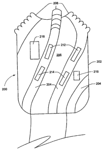
Referring to Figure 2, depicted is a long gauge drill bit having sensors,
according to
15 an exemplary embodiment of the present invention. The long gauge drill bit
200 comprises a
bit face having cutting teeth 208, a long gauge portion 202 of the bit 200;
flutes 204
extending from the teeth 208 and over the long gauge portion 202. In the
flutes 204 are
sensors 212 and 214 and in the long gauge portion 202 are electronic inserts
216 and 218
adapted for electronics packages associated with the sensors 212 and 214. The
long gauge
drill bit 200 is part of the BHA 100 and is attached thereto with, for
example, a coupling 210.
The flutes 204 may be in contact or near contact with the wall of the borehole
'120.
The sensors 212 and 214 are used to gather information about the formations
122 surrounding
the borehole 120. Preferably the long gauge portion 202 of the bit 200 may be
sufficiently
standardized to accommodate inserts for placement of desired sensors 212 and
214. The
sensors 212 and 214 may be for example, but not limited to, highly focused
ultrasonic sensors
for obtaining acoustic reflective images of the wall of the borehole 120,
electrodes for
measuring small variations in the resistivity of the formations 122 around the
borehole 120,
small high frequency antennas sensitive to the local electromagnetic response
of the
formation or to fields generated as a result of the drilling process, short
range highly focused
gamma or x-ray scattering sensors, rapid chemical sensors, Micro-Electro-
Mechanical
CA 02550821 2006-06-21
WO 2005/062830 PCT/US2004/042748
16
Systems (MEMS) and the like. At-bit inclination (ABI) sensors, e.g., triaxial
accelerometers,
may be used for determining inclination of the long gauge drill bit 200 during
drilling
operations. All of these types of sensors are well know to those skilled in
the art of
directional drilling.
It is contemplated and within the scope of the present invention that high
resolution
measurements may be performed with substantially identical sensors 212 and
214. These
sensors 212 and 214 may be spaced apart axially and/or azimuthally by some
distance (e.g.,
six inches) Cross correlation calculations may be used to determine a time
interval required
for a detected formation 122 to move the distance between the sensors, thereby
determining
the downhole drilling rate of the BHA 100.
The sensors 212 and 214 may be chosen for their ability to survive in the
downhole
drilling environment as well as obtain data from which a useful image could be
constructed.
It is also within the scope of the present invention that multiple sensors 212
and 214 may be
placed in a single bit 200 and thereby construction of different,
complementary images would
be possible. For example, electromagnetic and acoustic sensors probe different
aspects of the
formation, and therefore different, properties would be expressed in the
image, often
providing additional complementary information.
Data for creating images from the sensors 212 and 214 may be stored in an
electronic
package(s) located in the inserts 216 and 218, however, it is preferable to
transmit this data
continuously to the LWD tool 106. There are several reasons for this: first,
there will be
greater processing power and storage capability available in the LWD tool 106;
the LWD
tool 106 will have a communications link with the surface drilling rig (not
shown) allowing
transmission of the data enabling its use for geo-steering applications; and
preferably the
most economic use of the limited space of the electronic inserts 216 and 218
is best utilized
for other applications and sensors, thus the use of the mass storage
capability of the LWD
tool 106 is preferable rather than placing a great deal of memory storage
capabilities in the
sensors 212 and 214, and/or electronic package(s) located in the inserts 216
and 218. A
relatively high band-width transmission system is preferable from the sensors
212 and 214
and/or electronic package(s) located in the inserts 216 and 218 to the
electronic systems in
the LWD tool 106. Such systems are available in the industry, e.g., acoustic
telemetry as a
CA 02550821 2006-06-21
WO 2005/062830 PCT/US2004/042748
17
"short hop" system from an ABI sensor system to a MWD system up the drill
string, and a
low voltage closed current loop system, both well know to those of skill in
the directional
drilling industry. Other transmission systems are also contemplated between
the
measurement components in the long gauge drill bit 200 and the LWD tool 106,
and will
function for the intended purposes of the present invention. Additional
electronic processing
module(s) and software may be implemented in the LWD string to accommodate the
in-bit
sensor(s). This module(s) may be located anywhere within the LWD tool 106.
Referring now to Figure 3, depicted is a schematic flow diagram of a process
for
determining images of formations 122 surrounding a borehole 120. The sensors
212 and/or
214 located on the flutes 204 may be used to take a plurality of data samples
while the bit 200
rotates. In step 302, the sampling process starts. In step 304, a plurality of
data samples may
be taken at rotational intervals, for example, 2 degree intervals in a 360
degree rotation within
a given period of time. For example, the time period may be five seconds long.
During this
five second period the bit 200 may rotate 15 times. It may be desirable, using
the azimuthal
sensors in the bit, to define an image pixel every 2 degrees, for 180 pixels
as the bit 200
rotates. The data would then consist of 180 pixels for the five second period
sample time.
Since the bit 200 rotated 15 times during the five second period sample time,
approximately
fifteen data'points (samples) would have been acquired for each pixel. In step
306, software
in the bit sensor 212 or 214 and/or its associated electronics 216 or 218
could compute the
average of the fifteen samples for each pixel. Then in step 308, the averaged
data may be
transmitted to the LWD tool 106 for future processing and/or transmission to
the drilling rig
floor. In addition, the sensed data may consist of a data stream accompanied
by azimuthal
information. This data stream may be transmitted to the LWD tool 106 where it
may be
further processed to form an image of the formation surrounding the borehole.
Referring to Figure 4, depicted is a schematic flow diagram of a process for
determining rate of penetration of a borehole. Information from two axially
spaced sensors
212 and 214 may be used to infer the rate of penetration by using a system
clock to infer the
depth between samples and combining all samples within a pre-specified depth
interval
(e.g., 6 inches). In step 404, a first pair of axially spaced data samples are
taken at a first
time. In step 406, a second pair of axially spaced data samples are taken at a
second time. In
CA 02550821 2006-06-21
WO 2005/062830 PCT/US2004/042748
18
step 408, a distance traveled by the bit 200 is determined by comparing the
first and second
pairs of axially spaced data samples.
Alternatively, rate of penetration estimates may be made by observing the time
interval between cessation of drilling (as viewed, e.g., by a rotational
sensor) and assigning a
fixed interval (e.g., 30 feet or 90 feet) for a stand of pipe. In addition,
for those drilling
systems where a telemetry downlink is available, the rate of penetration or
actual distance
penetrated may be telemetered from the surface to the downhole system
(however, some lag
may be expected between the instantaneous downhole rate of penetration and
that measured
at the drilling rig floor).
The present invention may be used to obtain an electronic image of the
borehole 120
either during drilling, or during the removal of the BHA 100 from the
wellbore. The LWD
tool 106 may have the capability of determining certain critical parameters
such as micro-
depth measurements and boundary dip angles on a "real-time" basis by
transmitting signals
indicative of the desired parameter to the surface via a mud pulse signal or
any other real time
measurement while drilling (MWD) system.
In accordance with known techniques, wellbore directional measurements can be
made as follows: a three axis accelerometer measures the earth's gravitational
field vector,
relative to the tool axis and a point along the circumference of the tool
called the tool face
scribe line. From this measurement, the inclination of the BHA 100 can be
determined to
provide an indication of the deviation of the wellbore with respect to
vertical. The three axis
accelerometer also provides a measure of "tool face angle," which is' the
orientation
(rotational about the tool axis) angle between the scribe line and the high
side of the wellbore.
Additionally, a three axis magnetometer measures the earth's magnetic field
vector in a
similar manner. From the combined magnetometer and accelerometer data, the
azimuth and
magnetic tool face angle of the LWD tool 106 may be determined. As one skilled
in the art
will understand, hole azimuth is the direction of the borehole projected onto
the horizontal
plane relative to North. In many situations, the wellbore is not vertical and
the bed
boundaries are not horizontal.
The invention, therefore, is well adapted to carry out the objects and attain
the ends and
advantages mentioned, as well as others inherent therein. While the invention
has been
CA 02550821 2006-06-21
WO 2005/062830 PCT/US2004/042748
19
depicted, described, and is defined by reference to exemplary embodiments of
the invention,
such a reference does not imply a limitation on the invention, and no such
limitation is to be
inferred. The invention is capable of considerable modification, alternation,
and equivalents
in form and function, as will occur to those ordinarily skilled in the
pertinent arts and having
the benefit of this disclosure. The depicted and described embodiments of the
invention are
exemplary only, and are not exhaustive of the scope of the invention.
Consequently, the
invention is intended to be limited only by the spirit and scope of the
appended claims, giving
full cognizance to equivalents in all respects.