Note: Descriptions are shown in the official language in which they were submitted.
CA 02554651 2006-07-31
SYSTEM AND METHOD FOR OPTIMIZING A TRANSIT NETWORK
Field of the Invention
[0001] The present invention relates to the field of transit networks. In
particular, it
relates to a system for optimizing the combination of vehicles, geographic
regions and financial sources that comprise the transit network and a method
of using the same.
Background of the Invention
[0002] The majority of large cities have a public transit network for
alleviating the
traffic flow created by passenger vehicles. As cities increase in size, the
number of passengers and transit vehicles on the network increases as well.
Over time, the efficiency of the transit network can begin to suffer if the
elements of the network are not properly optimized, in particular the
determination of transit routes and allocation of drivers and vehicles to
these
routes. Furthermore, with the demand for increased transit use as a means of
reducing pollution and environmental damage from single-passenger
vehicles the need to optimize transit networks is greater now than ever
before.
[0003] One of the objectives in providing a public transit system is to
minimize the
social and economic impact created by the transportation demands of the
population of a city of any size. Particularly in North America, the
population continues to rely heavily on individual automobiles for
transportation, and the change to widespread use of public (mass) transit has
been slow in coming. As a result, major metropolitan areas, such as Los
Angeles, California and Toronto, Ontario, find themselves dealing with a
serious two-pronged issue of pollution and traffic congestion before even
considering the socio-economic impact of institutionalized automobile use.
[00041 The continued reliance on individual automobiles has hindered progress
in
addressing the envirorunental issues created by these vehicles. Currently,
- 1 - File No.74543-03(KB)
CA 02554651 2006-07-31
the vast majority of automobiles operate on gasoline-powered internal
combustion engines, which produce measurable amounts of airborne
pollutants while operating. These airborne pollutants, besides creating air
pollution and its associated problems, also create water pollution as they are
removed from the atmosphere. In addition, spillage and leakage of the fuels
and lubricants used in these engines leads to soil and water pollution.
[00051 In addition to environmental issues raised by the use of individual
automobiles, there are also socio-economic issues. In the absence of
available public transit, many people and families are effectively forced to
own and use at least one automobile, and often two or three, if they can
afford to do so. The cost of even a single automobile becomes a substantial
financial burden when the totals costs of financing, fuel, insurance,
maintenance, repair and parking are factored in. Also, the costs of
maintaining the road and highway infrastructure to meet the demands of the
volume of automobile traffic using these roads and highways represent a
major public expense, whose cost is passed on to individuals in the form of
taxes and tolls.
[00061 As another result of the widespread use of individual automobiles, the
development of infrastructure necessary for a successful public transit
system is inhibited. The parking requirements for users of retail and
commercial building space often limit accessibility by public transit. In low
density urban and suburban areas where individual automobiles are most
common, this problem is greater, making public transit less efficient and
useful in those areas where it would be of the greatest benefit.
[0007] Conventional public transit systems include buses operating on fixed
routes,
as well as one or both of light rail systems and regular rail systems,
possibly
including an elevated train or subway system. Rail systems often have a
large ridership in areas with a high population density, however, the costs of
purchasing land and constructing tracks tend to prohibit expansion of these
systems on a wider scale. In addition, rail systems that service areas of
lower population density, such as suburban-downtown commuter trains, are
- 2 - File No.74543-03(KB)
CA 02554651 2006-07-31
incomplete solutions as the users are still required to travel to and from the
rail stations to their final destinations.
100081 Using buses to fill the endpoint gaps in the rail systems, as well as
providing
conventional bus service, partially alleviates this problem. Unfortunately,
buses suffer from the limitation of operating on the same roads and
highways that are used by individual automobiles, making scheduling and
adhering to schedules very difficult. Also, buses contribute somewhat to
existing traffic problems when operating in high-traffic areas due to their
size and operating characteristics. Another problem in areas with a low
population density is that stop locations are often widely spaced and may not
be conveniently accessed by all potential users. Coordinating transfers,
especially where the user is changing between vehicles operated by different
transit operators, is another problem.
[00091 The result is that currently the majority of the population do not use
public
transit as it does not present an efficient solution to their transportation
needs. Although public transit is less expensive, sometimes substantially,
than an automobile, the inconveniences and inefficiencies in access and
scheduling prevent many potential users from considering public transit as
an option.
[00101 One potential solution is automation. Over the past two decades,
transit
agencies have made substantial investments in automating many of their
fixed route functions, including scheduling, operations, passenger
information, mapping, and ridership data gathering. While each of these
automation initiatives has produced substantial value in its own right,
collectively they have created a vast amount of data, much of which is stored
and used in disparate parts of the organization. As many agencies struggle
with the conflicting demands of a growing population and declining funding,
the need to manage data to come up with workable, long-terrn solutions has
become more and more important.
[00111 In the face of shrinking budgets and growing demand for public
transportation, transit agencies are struggling to find every possible
- 3 - File No.74543-03(KB)
CA 02554651 2006-07-31
efficiency and incremental productivity increase to stretch their resources.
Accordingly there is an ever-increasing requirement to analyze and report on
ridership, performance and other metrics at the local, state/provincial and
federal levels. Agencies seeking capital and operating funds also must
provide more and more detailed reports about their operations, plans and
needs than ever before. Technologies developed in the past 20 years have
made some of this easier - computerized scheduling, mobile computing and
geographical information systems can all generate the data necessary to find
more efficient ways to operate, and to inform funding agencies about where
their transit dollars are being spent.
[0012] Transit companies are now able to use advanced Geographical Information
Systems (GIS) software applications that can perform complex spatial and
statistical analyses needed to synthesize disparate data into a meaningful
context. GIS requires a high level of technical knowledge that may not be
available to many agencies. Such organizations have a need for tools to
manage their data or lose its value.
[0013] Regardless of their size or the degree to which they are automated, all
transit
agencies have internal data: schedule and route data, passenger counts,
farebox information, bus stop inventories, vehicle location data all exist,
usually in different parts of the organization. Some or all of them may be in
databases, or in thick paper files or simply in the heads of the planning,
scheduling and operations staff.
100141 External data are also ubiquitous: Census information, school
enrollments,
maps, employment statistics, welfare rolls, and other third-party data.
Additional region or country specific data, such as ADA (Americans with
Disabilities Act) zones in the United States, may also be included. A system
is needed to collect and analyze all of this data to serve the community, save
money, inform funding requests, comply with regulations and support
decision-making at the senior transit management level.
[0015] Another problem is that for true optimization of a transit network all
the
potential network considerations must be factored in. To date, optimization
- 4 - File No.74543-03(KB)
CA 02554651 2006-07-31
methods have focused on one particular consideration or another, deeming
the whole to be too complex or contain unnecessary considerations.
[0016] The first consideration is the types of vehicles used in the transit
network.
The transit network may consist of a single type of vehicle traditionally
associated with transit, such as buses or a subway. Or the network may
consist of more specialized or regional vehicles, such as ferries, streetcars
and vans. Most often, a transit network will have some combination of
different vehicles. Each type of vehicle has its own separate requirements,
not only in conventional terms of fuel, maintenance and passenger capacity,
but also types of routes (fixed or variable), number of vehicles available at
one time and accessibility (e.g. subway/train stations, bus stops). As a
result, any system of optimizing the transit network must be able to factor in
all available types of vehicles, as well as allow for the addition of new
types
of vehicles when introduced.
[0017] The second consideration is the geographical region or regions serviced
by
the transit network. A small network may be restricted to a single city or
municipal region. Larger networks may link several municipal regions (i.e.
a metro area for a city) or even several cities. The largest networks may
still
further include inter-city, inter-state and even inter-country transit
services.
The optimization system must account for many different restrictions for
each region and identify any parts of the network that cross regions.
[0018] The final consideration is funding. While most transit operators
collect fares
from riders, the majority are also subsidized by one or more levels of
government. In addition, some transit operators may include privately
funded, such as by advertising, or charitably funded networks within the
larger whole. Again, the optimization system must account for these
funding elements in determining such factors as passenger eligibility and
minimum fares for routes. Additionally, rider tracking should be included
for proper reporting as part of the optimization process.
[0019] Many transit planning departments are well-equipped to gather data for
these
considerations; however, very few have the tools needed to analyze the data
- 5 - File No.74543-03(KB)
CA 02554651 2006-07-31
so as to optimize their operations. An example is in the area of forecasting
demand. Demand forecasts build on the demographic and location data to
extrapolate future trends. Using census data it is fairly straightforward to
forecast population growth, the make-up of a given area and the economic
conditions that might prevail in two, five or ten years' time. What is much
harder to do is to apply this information to the task of transporting people.
Variables that can have a profound impact on transit use include fares,
service frequency, length of trip and the propensity of a given group (e.g.
vehicle owners) to use transit in the first place. AVL (Automated Vehicle
Location) and APC (Automatic Passenger Counter) data can play a large role
in this area. Both of these technologies represent significant opportunities
to
capture valuable data, particularly once integrated into a proper optimization
system.
[0020] Furthermore, many transit systems have automated transit information
systems, many of which offer itinerary planning through web or IVR
(Interactive Voice Recognition) interfaces. Data from these interfaces is
combined with trip planning data from agent-attended call centers, which
also offers a rich source of planning data. By analyzing which origins and
destinations have resulted in failed itinerary requests, it is fairly easy to
identify areas in need of better services. Good planning tools should be able
to import this data directly from the customer information or scheduling
databases to avoid errors and the costs of re-entering the data.
[0021] Spatial analysis can be used to help synthesize the statistics and
apply them
in the real world. Spatial data describe features such as a census tract, a
bus
stop or a fixed bus route in terms of its geographical location (longitude and
latitude coordinates). A GIS tool is able to use these spatial data to
illustrate
the relationships between features, usually on a map. For exarnple, a GIS
can help analyze census data in relation to a bus route to show the number of
people who do not own vehicles that could be served by that route. Taking it
a step further, a GIS can extrapolate the proximity of a given group of people
to a feature. An example might be the number of school age children who
- 6- File No.74543-03(KB)
CA 02554651 2006-07-31
live within a half mile of a bus stop, or the number of ADA-eligible
passengers who must travel from one area of the city to a particular dialysis
clinic. Using spatial data, a GIS tool can produce valuable information such
as walking distances, intermodal overlaps, under-served or over-served
neighborhoods by looking at routing and customer information data from a
variety of systems.
[00221 The visual nature of spatial data analysis makes it much easier to work
with
vast amounts of information and to quickly see patterns, redundancies, gaps
and inefficiencies. The problem with many GIS tools, particularly for
smaller agencies, is that they require advanced spatial and statistical
analysis
skills that may not be available or affordable.
[00231 There are, of course, data that cannot be analyzed spatially, including
temporal information such as schedules, work and pay rules and budgets.
An optimization system must be able to join both spatial and statistical data
to produce meaningful analyses, and to become part of an agency's
corporate intelligence.
[00241 While primitive GIS planning systems have existed in one form or
another
since the mid-1960s, and in the past ten years have come into widespread
use in a number of industries, particularly forestry, mining, agriculture and
other land-intensive activities, a multinodal, multiregional GIS-based system
for optimizing a transit network does not exist.
[00251 Another aspect to consider is that automated traveler information
systems
have become one of the primary tools for transit operators seeking to
increase ridership and improve customer satisfaction. In the past five years,
a number of new technologies have made the development of such systems
more affordable and more feasible for most agencies. Solutions in use range
from downloadable system maps on transit web sites to wireless trip
planning services to bus arrival countdown systems at the stop level. While
the vast majority of larger agencies, and a compelling number of smaller
organizations are embracing passenger information services, very few are
doing so at the regional level.
_ 7 _ File No.74543-03(KB)
CA 02554651 2006-07-31
[00261 For the past few years, regional governments and transit agencies have
been
making substantial investments in producing travel information in an effort
to boost ridership and improve passenger satisfaction. From producing
better travel guides to posting bus-stop level schedules to arming call center
representatives with printed maps and headway books, the past 25 years has
seen gradual improvement to the ways in which transit agencies
communicate with their riders.
[0027] Despite this progress, studies have shown that the perceived or actual
difficulty of obtaining information remains a key impediment to wider use of
transit services. Poor information accessibility poses a barrier to public
transport use that is as serious as physical access barriers. In response to
this, many transit agencies have made the deployment of automated travel
information services a priority.
[00281 For public transit, such services include a number of technology
solutions
that help passengers make better decisions about how and when they travel.
Information available through such systems typically includes service areas
and routes, scheduled departure times, transfers, fares, general information
and links to other transportation services. Automated travel information
systems can deliver the information through a variety of media including
interactive telephone information systems (IVR), Internet-based systems,
terminal and wayside information centers, kiosks, and in-vehicle display and
annunciator systems.
[00291 What is needed, in addition to providing route maps, schedules and
other
service information, is the implementation of automated trip planning
services. These automated services should augment or replace those
conventionally provided by call center staff, who traditionally relied on
printed materials such as route maps and headway books. The first step to
automating passenger information services involves developing transit
databases and software that call center representatives can use to help
passengers develop travel itineraries, determine fares and minimize walking
or transfers. Based on one or more parameters such as a starting point,
- g - File No.74543-03(KB)
CA 02554651 2006-07-31
destination, target departure or arrival time, these services should provide
passengers with detailed itineraries optimized for travel time, walking
distances, number of transfers and fares.
[0030] Advancements in technology have made information services more
affordable for small and medium agencies to implement. Initially installed
at the call center and accessible only to customer service representatives,
some agencies have since introduced Internet-based pre-trip information
systems, enabling passengers to interact directly with the software via a Web
browser. Inroads have also been made into providing trip planning using
IVR technology. The net effect of these different interfaces has been to
make travel information more accessible to current and potential transit
users. This in turn is believed to facilitate wider use of public transit.
These
technologies also greatly reduce call center volumes, hours of operation and
staffing requirements, producing cost savings that, over time, recover the
technology investment in alternative channels.
[0031) Despite better-informed riders and the ability to push detailed
information
through a variety of channels, agencies are still facing pressure from
government to improve mobility, reduce urban congestion and run more
efficient systems. There are many cultural and economic reasons behind
lack of transit use, but one key means of promoting the use of public
transportation is by developing integrated transit networks. The fact is that
transit users frequently need to use multiple transit operators as they travel
to
and from offices, shopping centers, restaurants, medical centers, recreation
facilities and other destinations.
[0032] The likelihood of using more than one operator increases significantly
as
passengers cross municipal and regional boundaries in the course of their
travels. As metropolitan areas continue to expand, public transit travel
between municipal areas will increase. Adjacent municipalities and
providers with overlapping service areas need to ensure that passengers can
access all the travel information they require from a single source. Regional
solutions offer agencies the opportunity to share resources and reduce the
- 9 _ File No.74543-03(KB)
CA 02554651 2006-07-31
overhead of implementing such a system on their own. Automated services
that let customers interact directly with the system through a web interface,
kiosk or IVR system, could substantially reduce call center costs.
[0033] Technological challenges arise out of the need to build an integrated
solution
from disparate parts. In a given group of agencies, the differences in size,
scope, budget and service mean substantial differences in IT environments,
routing and scheduling applications and the ways in which customer
information is generated. These systems could range from sophisticated
infrastructures with integrated databases, GIS mapping and fully-automated
routing, scheduling and dispatch to manual, paper-based or semi-automated
processes with only basic IT resources.
[0034] To further complicate matters, while many larger operators maintain
detailed
information about the vehicles, routes, and bus stops, smaller operators may
have this data only on paper, if at all. Similarly, scheduling databases will
differ from one operator to the next, and may not exist in organizations that
schedule manually. An information system must be designed to
accommodate many disparate operational and technological environments;
the software cannot impose a single solution on agencies with different
characteristics, nor should it matter what kind of scheduling and mapping
software the data come from. The flexibility to maintain and access data in
different formats is essential. The system must also enable service providers
to develop a regional architecture that best suits their operational
characteristics and existing technology infrastructures.
[0035] A typical public transit operator (PTO) will have implemented some form
of
passenger information system that may or may not include schedules, fares
or trip planning. However, with no integration of data and services, these
systems do not "talk" to one another, and it falls to the passenger to
determine how the services connect and when and where transfers between
the services take place. Single agency services offer the advantages of great
flexibility, local control, easy security setup and lower communications
costs; however, hardware, software, support and administration costs will be
- 1 O - File No.74543-03(KB)
CA 02554651 2006-07-31
higher for each agency. Furthermore, PTOs miss out on the opportunity to
participate in a regional transportation network, and smaller services may
lack the resources to extend their delivery beyond a basic call center.
[0036] In contrast, transportation networks are a thoroughly centralized
solution, in
which one agency delivers schedule and fare information and trip planning
for the region. Individual operators are responsible only for providing up-to-
date data to the central server. This centralized configuration is more cost-
efficient than the distributed system as it eliminates multiple infrastructure
costs such as telecommunications equipment and office space.
[00371 There is a need for a transit network optimization system that is
capable of
taking all the above considerations as input and producing optimized results
for determining transit routes as well as vehicle and driver allocation. The
system should further be able to respond to passenger inquires and provide
an optimized itinerary based on passenger-selected criteria.
Summary of the Invention
[0038] One aspect of the present invention consists of a system for optimizing
the
operation of a transit network, where the transit network including one or
more transit operators, each of the transit operators providing one or more
transit vehicles, including: ferries, trains, elevated trains, subways, buses,
streetcars, vans and taxis. The system is comprised of a) a data collection
component adapted to collect data from said transit operators and said transit
vehicles; b) a data processing component adapted to process said data to
determine viable routing options within said transit network for a passenger
to travel from a start point to an end point within said transit network; c)
an
algorithm for assessing said viable routing options to determine a routing
option that minimizes one or more of: fare, time, travel distance, transfers,
distance from the start point to entry onto the transit network; distance from
the end point to entry onto the transit network or any other passenger-input
criteria; and d) a data display component for presenting the routing option
so determined to the passenger.
- 11 - File No.74543-03(KB)
CA 02554651 2006-07-31
[0039] Another aspect of the present invention consists of a method of
optimizing
the operation of a transit network utilizing the system. The method
comprises the steps of: a) collecting data from said transit operators and
said
transit vehicles; b) processing said data to determine viable routing options
within said transit network for a passenger to travel from a start point to an
end point within said one or more transit networks; c) analyzing said viable
routing options to determine a routing option that minimizes one or more of:
fare, time, travel distance, transfers, distance from the start point to entry
onto the transit network; distance from the end point to entry onto the
transit
network or any other passenger-input criteria; and d) presenting the routing
option so determined to the passenger.
[0040] Other and further advantages and features of the invention will be
apparent
to those skilled in the art from the following detailed description thereof,
taken in conjunction with the accompanying drawings.
Brief Description of the Drawings
[0041] The invention will now be described in more detail, by way of example
only,
with reference to the accompanying drawings, in which like numbers refer to
like elements, wherein:
Figure 1 is a prior art diagram of the information retrieval system for a
transit
operator;
Figure 2 is a prior art diagram of the information retrieval system for a
transit
network;
Figure 3 is a diagram of the information retrieval network for a transit
operator
using the optimization system of the present invention;
Figure 4 is a diagram of the information retrieval network for a transit
network
using the optimization system;
- 12 - File No.74543-03(KB)
CA 02554651 2006-07-31
Figure 5 is a diagram of the modules within the optimization system;
Figure 6 is a route diagram for a transit network; and
Figure 7 is a route diagram for a transit network indicating a specific route.
Detailed Description of the Preferred Embodiments
[0042] The invention consists of an optimization process that unifies three
disparate
elements of a transit network: vehicles and routes, geographic and
demographic regions and funding sources. The data most transit agencies use
comes from a variety of internal sources including: schedule databases,
automatic passenger counting applications (APC), automatic vehicle location
systems (AVL), customer information centers including automated voice
systems (IVR) and web-based services, electronic faring ridership surveys,
random ride checks, and bus stop databases. External data sources include:
census data, map files, National Transit Database information, employment
statistics, land use data, school enrolment, ADA clients, and welfare
recipients.
[0043] This data is relevant to three key areas of transit agency performance:
schedule and route adherence and ridership analysis; demographic and
location analysis (which portions of the population are or are not being
served by transit and what parts of the service area are adequately covered);
and demand forecasting (ridership growth and financial planning).
Diagrams
[0044] In the prior art, the passenger is the center of the information/data
flow as
shown in Figure 1. Each public transit type e.g. buses, subway, paratransit
has its own data transfer to/from the passenger. Similarly, private transit
types e.g. taxi, airline has a separate data transfer. Thus, while information
passes from the bus service (i.e. routes, schedules, fare prices) to the
passenger, information from the subway service (stop locations, schedule,
fare prices) requires a separate request. Furthermore, the onus falls on the
- 13 - File No.74543-03(KB)
CA 02554651 2006-07-31
passenger to combine and assess the information from the two sources,
which may be in substantially different formats.
[0045] On a larger scale, the information/data flow continues to operate in
the same
way. For multiple regions, as shown in Figure 2, the passenger must
separately request information from public transit operators (PTOs) in each
region, as well as commercial transit operators (CTOs). The difficulties for
the passenger are now compounded as each region then breaks down into the
different services as shown in Figure 1.
[0046] The optimization system of the present invention acts as an information
hub
as shown in Figure 3, effectively replacing the passenger at the center of the
information network. Data from the different public transit services and
commercial transit services flows in and out of the optimization system.
Now, when a passenger makes a request, it is handled by the system, which
provides all the data for all the services in one request and in a common
format. As a result, the ability of the passenger to assess the information
and
make an informed decision about transit use is greatly simplified.
[0047] The optimization system is scalable, as shown in Figure 4, to perform
the
same data collection and transfer handling for a multi-region transit network.
Data from the PTOs in each region, as well as the CTOs, is collected by the
optimization system, making the information for all regions available from a
single source. Significantly, the system can, if necessary, perform this
function without any additional communication between the PTOs.
[0048] The optimization system is composed of different modules as shown in
Figure 5 for handling the various tasks required to operate a transit network.
The modules can generally be categorized into four types: scheduling,
dispatching, vehicle/driver systems and passenger interface systems.
100491 The scheduling module contains all the route and stop information for
the
network. Locations for bus stops, subway stops, train stops,
arrival/departure times and maps of bus and subway routes are all contained
within the module. The scheduling module is further capable of analyzing
the route and stop data to identify stops with unusually high or low use and
- 14 - File No.74543-03(KB)
CA 02554651 2006-07-31
suggest modifications to route and stops for optimized passenger capacity
and/or ridership.
[00501 The dispatching module contains the driver and vehicle availability
list,
driver assignment and work schedules, and safety and labor (i.e. union
contract terms) requirements. The dispatching module takes in the schedule
data from the scheduling module and combines it with the dispatching data
to create an assignment schedule assigning vehicles to routes and drivers to
vehicles. The dispatching module is further capable of handling any other
related tasks, including employee payroll records and vehicle maintenance
tracking.
[0051] The vehicle/driver systems module contains all the data gathered by on-
board vehicle equipment for each vehicle and its associated driver. Types of
on-board vehicle equipment used include AVL, APC, electronic fare
collection, GPS locators, idle monitoring systems, vehicle status monitors
and emergency/alarm systems. The module is thus able to provide up-to-
date status reports on request, as well as automatically generate alerts and
notifications. These alerts can include providing a notice to passengers that
a vehicle is running ahead or behind schedule or advising maintenance
personnel that a vehicle is incoming for an oil change.
[0052] The last module is the passenger interface module. The module contains
all
of the interfaces used for communicating with passengers. These interfaces
typically include a call-center, IVR systems, a website, kiosk or in-vehicle
information system for passengers to make route inquires, received
optimized route data and report complaints or incidents.
[0053] The division into modules presented herein is for ease of presentation
and to
more accurately reflect the categories of tasks performed by the optimization
system. However, in a practical application, there will be many modules
handling various specialized tasks that are integrated into the whole system.
Vehicles and Routes
[0054] The first aspect for optimization is assessment of the number and types
of
vehicles available on the transit network. This assessment then leads into
- 15 - File No.74543-03(KB)
CA 02554651 2006-07-31
the determination of available routes. From there, optimal route planning for
single passengers, multiple passenger groups and the network as a whole can
take place in conjunction with geographic and financial considerations.
[0055] Vehicles can be split into two initial types: fixed and variable. Fixed
vehicles generally have their routes defined by geography, such as ferries
and planes, or by physical requirements (i.e. tracks) such as trains, elevated
trains, subways and streetcars. Variable vehicles are generally only limited
by the restrictions of available roads and include vehicles such as buses,
mini-buses, vans, and taxis. This division of vehicle types is useful for
optimization, as changes for variable vehicles (i.e. changing the locations of
bus stops) are much more readily accomplished than changes for fixed
vehicles (i.e. building a new subway or train station).
[00561 While the distinction is made for optimization purposes, the
classification as
a "variable vehicle" does not preclude the vehicles from operating on a fixed
route, like buses stopping at bus stops on a pre-determined route and a "fixed
vehicle" may operate on a variable route by omitting stops, like express
commuter trains. For most purposes, transit networks use fixed routes for
passengers, regardless of vehicle type. However, some transit networks
include special networks (herein called "paratransit") for people with
disabilities or other restrictions. These paratransit networks typically use
variable routes and lower-capacity variable vehicles, particularly mini-buses
and vans.
[00571 Most transit operators use a combination of fixed vehicle and variable
vehicle services. Furthermore, many passengers may be required to switch
vehicles at some point during their journey. For example, a passenger may
begin a trip on a commuter train, transfer to a subway, and then take a
streetcar or bus to their final destination, with the additional possibility
of
walking from transfer to transfer, as well as from the bus stop to the final
destination point. The optimization system needs to consider the various
transfer points and vehicle switches that may be required to travel between
any two destinations within the scope of the network.
- 1 6- File No.74543-03(KB)
CA 02554651 2006-07-31
[0058] Another factor is expansion. Most transit operators are constantly
evolving,
whether by adding new vehicles, building new tracks and stations, or even
adding completely new services to the network. The optimization process
needs to be able to consider these possibilities when put before it. The
impact of a proposed expansion, whether through construction or
incorporation of existing adjoining transit networks, should be capable of
being assessed by the optimization process.
[0059] As an example of the scope of vehicles and routes available in a
typical
transit operator, the city of Vancouver, Canada has a transit system
consisting of a multi-stop single route commuter train, a point-to-point
ferry,
a multi-stop, multi-route elevated train (SkyTrainTM) and a conventional bus
system, along with a paratransit network of mini-buses and vans.
[0060] Additionally, many public transit operators are required to report on
passenger miles, route productivity and performance. Data for such reports
come from several sources, including the scheduling database; mobile
technologies such as AVL or on-board mobile data terminals (MDTs); APC
and electronic faring. The optimization process can be used to correlate this
data, preferably using a GIS planning application wherever applicable. At
the bus stop level, for example, it is possible to determine the most and
least
used stops on a route, the number of boardings and alightings at each stop
and to compare that with amenities such as benches or shelters. This allows
stops to be sited more conveniently and to place the amenities where they are
most needed.
[0061] Ridership analysis is also essential to understanding the overall
performance
of a transit system. It allows for the identification of the busiest and least
busy trips and those with chronic schedule adherence problems, allowing the
transit operator to optimize the overall schedule. Additionally the data can
be extracted to determine ridership, passenger miles and other metrics, and
automatically generate any required reports. Routes can be spatially
analyzed in a number of ways to identify the busiest or least busy times of
day, the most appropriate vehicle for the route or time of day and the most
- 17 - File No.74543-03(KB)
CA 02554651 2006-07-31
and least productive routes. Spatial analysis using maps would also quickly
highlight features that affect the productivity of a given route, such as
proximity to areas of employment, social services or community attractions.
[0062] For fixed route agencies that also provide ADA or similar paratransit
services, a route analysis could assist in identifying areas where fixed
routes
can replace or supplement demand response services. The optimization
process should permit transit operators to identify on-time performance
short-falls or unproductive routes and then be able to find ways to resolve
the problems by adjusting schedules, headways, vehicles or the routes
themselves.
[0063] Another example of optimization comes from considering smaller transit
operators in smaller regions, such as rural areas. By using the optimization
process, existing services can be combined to provide greater efficiency and
increase transit availability without the need to increase expenditures in
terms of additional vehicles and/or drivers. As a result, a level of transit
service can be provided which is substantially greater than that currently
available in these types of regions.
[0064] For example, many communities use school buses to transport children
from
their home to school and vice-versa. The buses are in operation for certain
time periods in the morning and afternoon and occasionally during other
times (field trips, sports teams, etc.). By incorporating the school buses
into
the optimization system, the transit operator is provided with a variety of
ways of increasing service through more efficient use of existing resources.
One way is to assign school buses to fixed routes that operate in the time
periods when the buses are not required for school use (mid-day, night
routes). Another way is to add the school buses to the pool of available
paratransit vehicles, to cover peaks in demand or routes within the existing
school bus route area. Yet another way is to simply add the school buses to
the pool of vehicles, making them available to cover emergencies,
breakdowns and similar unexpected situations that would otherwise
seriously disrupt service.
- 1 g - File No.74543-03(KB)
CA 02554651 2006-07-31
Geography and Demographics
[0065] The next consideration for optimization is geography or, more
specifically,
the division of geographic regions covered by the transit operators along
with the demographic data used to describe each region. All but the smallest
of operators will be expected to cover more than one region. Depending on
the nature of the operator and the regions, travel from one geographic region
to another may be built in or may require substantial adjustments. Handling
the passenger transfer from one region to another forms a significant
component in the optimization process.
[0066] A common scenario is that inter-region transportation is covered by one
type
of vehicle, such as commuter trains for inter-city transit, and transportation
within the region is covered by another type of vehicle, such as buses or
subways. With this arrangement, passenger transfer from region to region
becomes complicated by the additional need to transfer from one type of
vehicle to another.
[0067] Outlying regions, particularly rural regions, may have limited or
restricted
service compared to other regions within the network. These types of
limitations must be heavily weighted in optimization adjustments. For
example, an outlying region which has only one route available has fewer
choices for optimization, however, optimization of the connections to the
core areas of the transit network become more significant due to the
consequences of missing a connection.
[0068] To consider the example provided by Vancouver, twelve municipal regions
(Vancouver, Burnaby, New Westminster, Richmond, Delta, Surrey, Langley,
Coquitlam, Port Coquitlam, Port Moody, Maple Ridge, Mission) are covered
by the transit network, with an additional separate bus system for the regions
of North Vancouver and West Vancouver.
[0069] In these cities, inter-regional travel is common among transit riders
and the
optimization process must provide an optimal way for riders to travel
between regions, considering all other factors presented herein.
- 19 _ File No.74543-03(KB)
CA 02554651 2006-07-31
[00701 The transit operators must also have a clear understanding of the
characteristics of the populations they serve and of the relationship between
transit services and the social and economic infrastructure of the community
as a whole. Demographic analyses rely on data from the Census Bureau,
city, state/province, or county agencies to build an accurate picture of the
population's age, income, housing, employment, mobility and many other
attributes. The optimization process should be able to work with these data,
in their myriad forms, to create statistical and spatial information that can
be
used to profile existing and potential passengers. Population data from the
census or a planning model will be aggregations typically covering multiple-
block areas (e.g., census blocks, census tracts, or transportation analysis
zones). These data may need to be disaggregated into the areas served and
not served by transit. The optimization system can do this and can also be
used to match individual address data to areas served and not served by
transit. Operators can apply statistical demographic data, such as vehicle
ownership or population density, to spatial information such as existing bus
routes to create a visual snapshot of who is being served in a given area. The
planners can also plot census data on a map, overlay bus routes and create
buffer areas around those routes to illustrate the demographic make-up of the
service area.
[00711 Hand-in-hand with the need to incorporate demographics is the need to
incorporate location data into the system. Location data describe where
physical elements are, including businesses, other transport services,
schools, hospitals, social services, daycare facilities and tourist
attractions.
By combining information about the population with data about where they
travel, operators can build on the schedule and ridership knowledge to use
the optimization system to create a truly holistic picture of the transit
service
as it stands and the changes that might be needed in future.
100721 For example, many agencies in the United States are struggling with
transit
support for Welfare to Work programs. Only about six percent of welfare
recipients own vehicles, and recent job growth has been primarily focused in
- 20 - File No.74543-03(KB)
CA 02554651 2006-07-31
suburban areas. Using GIS tools, planners are able to identify gaps in transit
accessibility and estimate the ability of workers to commute to job locations.
A recent study in Boston demonstrated that while 99 percent of welfare
recipients lived within one-half mile of transit service, only 43 percent of
the
jobs in the area enjoyed the same proximity. This type of information is
readily available and presentable as part of the optimization process,
allowing for quicker response to issues and removing the need for expensive
external surveys and consulting.
[0073] The optimization system provides tools that allow for detailed
exploration by
selecting points, stops or polygons to more closely analyze the make-up of a
specific part of the service area. These data can then be exported as a report
or summary or into another application for manipulation. Operators can also
create temporary routes, points and polygons to perform scenario analyses
on proposed changes, or they can manipulate the demographic data
themselves to assess the impact of population changes on the transit service
offering.
[0074] In addition to evaluating who is using a transit service, demographic
analysis
is of enormous value to customer information and marketing departments,
who must have an in-depth understanding of their audience characteristics in
order to provide appropriate information and services. For example,
demographic analysis may indicate that a given route serves a particular
language group, and that customer service may need to be offered in that
language. For marketing departments that are trying to build ridership, a
spatial understanding of vehicle ownership, household income and
employment can pinpoint where best to focus marketing resources to
promote the transit service. At the executive level, these data are also
critical.
Financial Sources
[0075] The final consideration for optimization is the financial sources which
fund
the transit operators. A primary source is rider fares. Another source is
government funding, typically from taxes, received from different levels of
- 21 - File No.74543-03(KB)
CA 02554651 2006-07-31
government. Private funding or charitable funding may also be used,
particularly for paratransit services.
[0076] Rider fares may be fixed or variable, and can be dependent upon several
factors, including the type of vehicle and region of travel, as discussed
above. Optimization can be used to determine which potential route is the
least expensive for travel from point-to-point. Also, optimization can be
used to assess vehicles, routes, and/or regions that generate a low number of
rider fares and suggest appropriate adjustments. The optimization process
may even be used to suggest fare prices, or changes in the fare system and to
assess the potential impact of such changes.
[0077] Government funding may be local (city/municipal), regional
(state/provincial) or federal, depending on the areas serviced by the network
and the policies of the government. Generally, funding would be derived
from the government's general tax revenues, however, it is also common to
have specific tax levies, such as taxes on property, fuel and vehicle
insurance
which are intended to directly fund transit networks.
[0078] Paratransit operators typically receive private or charitable funding
and have
specific requirements that must be met for a passenger to be eligible. By
using the optimization process to assess patterns with the usage of these
networks, if may be possible to combine them with conventional transit
networks, and the attendant fare charges, to reduce passenger travel time and
increase passenger capacity.
[0079] The optimization system can also assess where received funds are being
used
in the transit network and determine if adequate funds are being received for
assigned purposes.
[0080] Additionally, received funding may be contingent on ridership, and the
effects on ridership resulting from the optimization process must be reflected
in the financial aspects of the model.
[0081] Financial concerns often have a significant overlap with regional
concerns.
For example, special transit levies, such as fuel taxes or vehicle insurance
taxes may only apply to regions serviced by the transit network. Also,
- 22 - File No.74543-03(KB)
CA 02554651 2006-07-31
regions with limited or restricted transit service may be exempted from these
taxes. Additionally, many transit networks use fare surcharges for travel
between regions, and the amount of these charges and the definition of
regional boundaries are often contentious issues.
[0082] By incorporating these financial considerations, the optimization
system can
be used to request increased funding based on increased ridership, or to
stretch limited funds farther, or a combination of both.
Optimization
[0083] The goal of the optimization process is to increase efficiency of the
transit
network, with the inherent benefit of increasing ridership. This goal is
achieved in several ways. Primarily, the optimization system collects
information pertaining to all of the above-listed considerations and generates
transit routes for the transit network along with vehicle and driver
assignments for these routes. Each consideration is assigned a weight by the
party seeking to optimize the network. For example, a priority could be set
to maximize inter-regional travel, resulting in increased commuter train
service and more inter-regional bus routes, while eliminating other regional
bus routes and reducing inter-regional fare surcharges. In general, the result
should provide an optimal combination of vehicle capacity, regional service
and financial balance.
[00841 Another use for the optimization process is to provide an optimized
destination-to-destination trip itinerary for any individual passenger subject
to any specific limitations requested by that passenger. This way,
passengers who want to use the transit network are readily provided with the
information necessary to make a conscious and informed decision on how to
use the transit network. The optimal itinerary generated can be based on
priorities such as lowest fare, fewest transfers or closest transit stops to
departure point and/or destination point.
[00851 Lastly, the combination of the three considerations set forth above
should be
continually reviewed to determine which changes must be implemented to
achieve the desired goal. Possible changes include fare prices,
- 23 - File No.74543-03(KB)
CA 02554651 2006-07-31
addition/subtraction of vehicles and the addition/subtraction of routes. Also,
the optimization data can be used for future planning, such as building new
subway/train stations and extending service to new geographic regions.
Finally, optimization allows for improved tracking of riders, which can be
used to adjust the funding levels received from goverrnnent and charitable
sources.
[00861 For a paratransit network as either part of the whole transit network
or as a
separate network the optimization process works in the same way.
Additionally, with parartransit, the number of riders serviced may be
increased by changing the number and types of vehicles and routes available.
This may be done by incorporating existing public transit services into the
paratransit services where possible.
Diagrams
[00871 As shown in Figure 1, prior art systems require the passenger (rider,
user) to
make individual contact with each different aspect of the transit network in
order to determine what transit is available and then what transit best meets
their needs. Bus routes and times are gathered from the bus network, train
stops and times from the train network and so forth. In addition, information
must be separately collected from commercial providers, such as airlines,
trains and taxis. The collected information, which is generally in different
formats, must then be assessed by the user, without any further support. The
difficulty of this task is one of the most significant barriers to transit
use.
[00881 By implementing the optimization system as shown in Figure 3, all
information passes through the system before going to any other aspect of
the transit network. The system acts as a central hub for all information
gathering, processing and requests.
[0089] Bus routes and schedules are received from the bus network, train stops
and
schedules from the train network, and so forth. Notably, information from
other networks is readily incorporated into the whole. Paratransit networks
can enter vehicle lists, availability and passenger eligibility criteria.
Commercial transit networks, such as airlines, can enter flight schedules or
-24- File No.74543-03(KB)
CA 02554651 2006-07-31
other relevant information. By uniting all this data in one location, a
uniformity of content can be provided, which enables uniformity of results
when data inquiries are made.
[0090] Besides the inherent advantages the system provides for a passenger,
there is
also a large advantage gained by the transit operators. The accumulation of
data allows for greater data analysis and data mining to improve the
efficiency of the transit services provided.
100911 At this stage, all of the optimization considerations are set forth.
The
different types of vehicles and routes available must be considered. Typical
optimization factors include overlap between bus route and subway routes,
connection times for train arrivals and corresponding bus departures,
identification of transfer points where riders must switch vehicles.
[0092] Regional issues must be factored in, including the identification of
regional
boundary zones, specific identification of inter-regional routes and targeting
of "hubs", such as central train stations and subway station, for specific
optimization.
[0093] Significantly, all those considerations act in concert with one
another. For
example, inter-regional travel (a geographic consideration) may require an
additional fare (a financial consideration) depending on which vehicle and
route are used (a routing consideration). If the rider takes an inter-regional
commuter train, the additional fare may be built in to the base fare price,
although commuter trains typically operate in limited time periods, so
additional bus service between regions may also be provided. The bus
service may also include passengers who are not traveling between regions,
so separate types of fares may be needed.
[0094] The optimization process looks at these different considerations and
provides
results that take all of them into account. In this example, one result might
be to reduce the additional inter-regional fare to increase ridership.
Alternatively, adding an additional commuter train could reduce demand for
inter-regional bus service, allowing those vehicles to be reassigned to other
existing or new routes. Another possibility is to modify the boundaries of
- 25 - File No.74543-03(KB)
CA 02554651 2006-07-31
the regions to increase the scope of regional service. Or all of these
optimization suggestions may be combined. These results are derived from
incorporating all relevant considerations into the optimization process.
[0095] By examining a large range of data, transit operators are able to build
a fairly
accurate picture of the future. Trends can be incorporated, such as
population density decreasing in downtown areas as jobs move further and
further into the suburbs; aging populations increasingly dependent on
traditional or paratransit services; declining road systems that suffer from
near-constant gridlock; etc. Thus, operators can explore the role transit
services might play in better adapting to meet the dynamic needs of the
public using the subject invention. Demand forecasting and spatial analysis
can be used to demonstrate the effects of new bus routes, expanded demand
response delivery, route-deviated services, light rail networks or different
fare structures.
[0096] The optimization process can also help predict which types of service
changes will have the most positive affects on ridership. The invention can
evaluate proposed routes against a number of criteria. In procuring financial
and policy support from all levels of government, transit operators must be
able to present a compelling look ahead, and clearly articulate their
strategies
for dealing with it. The optimization system provides mechanisms for
forecasts, analysis and scenario modeling, which in turn allow staff and
consultants to spend their time working on the solutions rather than
searching for the problem.
[0097] An example of the optimization process is readily demonstrated by its
application to passenger scheduling and itineraries. The information
gathering and processing performed by the optimization process adds several
advantages to passenger scheduling that would not otherwise be available.
The primary result is that a single passenger scheduling algorithm can be
used where previously multiple passenger scheduling algorithms were
required
- 26 - File No.74543-03(KB)
CA 02554651 2006-07-31
[0098] One advantage is that a single algorithm can now be used to handle
multiple
modes of transport. A user enters a trip request (consisting of origin,
destination and desired departure time) and asks the algorithm to suggest
possible transit solutions. The algorithm returns a list of possible
itineraries
that includes paratransit vehicles, fixed route vehicles, flex route vehicles
and even taxis and connections to other PTOs and CTOs. With the prior art
using different algorithms for different operators, the trip request would
have
to be directed to each algorithm independently, in some cases requiring that
the trip request data be formatted differently. Also, each algorithm would
return the results in a different data format, placing a burden on the user
interface to try to integrate them all.
[0099] The biggest separation between the past algorithms was between the
fixed
route and variable-route (paratransit) algorithms. Consider using a city's
existing itinerary lookup website and requesting directions on how to get
from point A to point B. It might tell you to get on a certain bus at route
101, transfer to a different bus at route 400 and so on. With this
optimization process behind it, the algorithm can now also suggest potential
alternatives such as taking a taxi or a dial-a-ride vehicle instead of, or in
combination with, using the fixed route buses. Existing transit algorithms do
not provide that degree of integration. This algorithm advances beyond this
limitation through the use of the optimization system.
[00100] Another advantage arises in the algorithm's ability to generate
transfers
between vehicles of different types. Not only can it return solutions where
each solution uses a different transit type, but it can also return a solution
that combines multiple types into one single itinerary. For example, it might
suggest a solution where a passenger is picked up by a paratransit bus, taken
to a transfer location where they transfer to a fixed route bus, then get off
at
another transfer point where they transfer to a taxi for the last leg of the
trip.
This type of solution offers a passenger more choices. For instance, it can
allow a passenger to book trips to places where fixed route buses are
unavailable while still using the fixed route bus for a portion of the trip.
It
- 27 - File No.74543-03(KB)
CA 02554651 2006-07-31
can also save money because fixed route buses are usually cheaper to use
than paratransit buses or taxis. For example, a special needs passenger that
cannot walk to a bus stop would traditionally have to take a paratransit bus
or taxi from door to door. This service is typically provided by paratransit
operators who are heavily subsidized by taxpayers. On long trips, if the
paratransit operators can use fixed route buses for part of the trip then they
can potentially save money. Backed by the information gathered by the
optimization system, the algorithm allows a variable route such as paratransit
or taxi to pick the passenger up right where they are and also to drop them
off right where they need to go while still using fixed route for portions of
the trip in between.
[001011 A third advantage gained by using the algorithm is that it unifies the
solution
costing model across all the types of transport. A solution cost is an
abstract
number assigned to each potential solution. It is used by the transit
operators
to help judge which solution is the best choice. It can be based on many
factors such as the amount of extra distance added to the vehicles, the
number of transfers involved, vehicle load utilization, passenger on-board
time and many others. With separate algorithms it is difficult to compare
costs for the same trip request because each algorithm has its own way of
digesting the multiple cost factors into one single cost. By popular analogy,
it was like comparing apples to oranges. However, with all the solutions
generated by a single algorithm, it is possible to unify the costing model so
that the relative costs of solutions involving different transport modes can
be
fairly compared, enabling more intelligent selections to be made. To
complete the analogy, using the algorithm, comparing a paratransit solution
to a fixed route solution is like comparing apples to apples.
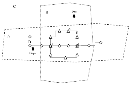
[00102] In Figure 6 five transit services are represented. A is a paratransit
service
that operates inside the horizontal A polygon. B is also a paratransit service
that operates inside the vertical B polygon. C covers the entire city and
represents a taxi service's operating area. D is a flex route that moves
between the diamond shaped bus stops. E is a fixed route that moves
- 28 - File No.74543-03(KB)
CA 02554651 2006-07-31
between the triangular stops. All of the 5 services are able to transfer
between one another at bus stops 1 and 2 as defined in table 2. A, B and E
can transfer between each other at stop 3.
[00103] The passenger scheduling algorithm works by dividing the trip solution
generation process into several phases. Phase 1 is the discovery of which
transit services operate in the vicinity of the trip's origin and destination
points. Phase 2 is the discovery of transfer patterns between origin and
destination transit services. Phase 3 involves finding times and vehicles for
each segment of each transfer pattern found in phase 2. Phase 4 calculates
the cost of the valid solutions found in phase 3.
[00104] Phase 1 introduces a concept called a transit service. A transit
service is an
abstraction of all the types of transport that the algorithm supports. A
service combines a type of transport with a representation of the area
serviced by that type, in effect a combination of the vehicle and route data
as
well as the geographic and demographic data that has been gathered and
analyzed by the optimization system. How the area is defined depends on
the type of transport. For a fixed route vehicle, it is defined by the bus
stop
pattern. A fixed route vehicle always follows a particular path through the
city streets. That path can be represented by its bus stop locations connected
together in a line. A paratransit vehicle has no fixed stops to define it. Its
route is ultimately defined by the trips it is assigned each day and that can
vary from day to day. In addition, many of the trips are not assigned until
shortly before it pulls out for the day. As a result, the trips on a
paratransit
bus cannot be used to define a paratransit service because they are not a
fixed entity. Like a taxi, a paratransit bus can go anywhere but for practical
purposes it is often restricted to certain regions, or zones, of the city.
Paratransit and taxi services can therefore be better represented by a polygon
that defines their service area rather than by a sequence of pre-determined
fixed stops. The passenger scheduling algorithm allows a variable route
service to be defined either way - either using the fixed stops assigned to
the
variable route, or by using a service area polygon assigned to the variable
- 29 - File No.74543-03(KB)
CA 02554651 2006-07-31
route. This is because a variable route is fundamentally considered as a
hybrid between a fixed route bus and paratransit bus.
[001051 Phase 1 involves finding all the transit services that operate in the
area of the
passenger's origin plus all the transit services that operate in the area of
the
passenger's destination. The services are then sorted, preferably in order of
proximity to the actual passenger's location. An alternative way to look at
this is that they are sorted in order of how far the passenger would have to
walk to use each service. For some modes, like paratransit or taxi, the
walking distance is essentially zero because these modes go directly to the
passenger's origin or destination point. For services based on stop points the
proximity is measured as the walking distance to the nearest bus stop for that
service. For services based on polygons, the proximity is based on whether
or not the passenger's origin or destination is contained within that polygon.
This phase produces a set of from/to service pairs but makes no attempt to
choose a vehicle or departure times or to work out a transfer pattern between
the services. The transfer pattern is left to phase 2.
[001061 Phase 2 is the center of the passenger scheduling algorithm. This
phase is
where the different types of transport are integrated. Phase 2 accepts the
list
of from/to services that were produced by phase land then works out
transfer patterns between each of those service pairs. Phase 2 uses a
recursive algorithm to walk through a transfer table. It can work out all
possible ways of transferring between the origin and destination services.
The transfer table is set up in advance as part of the optimization process.
It
allows the passenger to decide which locations are good for making transfers
and which services to include or exclude from any particular transfer.
However, users do not have to define the complete transfer patterns - only
the transfers between two adjacent services. The algorithm in phase 2 then
does the rest by dynamically building more complex transfer patterns out of
the simple from/to transfer pairs.
[001071 In the present example, phase 2 generates coded transfer patterns
based on a
transfer table. For example, the pattern A-1-E-3-B means: "take service A to
-30- File No.74543-03(KB)
CA 02554651 2006-07-31
stop 1 then transfer to service E which you take to stop 3 where you transfer
to service B which takes you to the final destination." This particular
transfer pattern is illustrated by the highlighted lines in Figure 7 below.
(001081 In Phase 3, each pattern must be expanded into a full solution that
involves
specific vehicles and arrival and departure times. This involves starting with
the first service in the pattern and finding all possible vehicles for that
service that can pick up the passenger and take them to the next drop-off
point. If there is a next service, then the drop-off point will be a bus stop
where the transfer takes place and so on down the line. When there is no
next service then the drop-off point will be the final destination. The pickup
and drop-off times are worked out for each vehicle. When moving on to the
next service in the pattern, the pickup time is restricted based on a small
transfer window around the previous drop-off. For example, if a vehicle
drops a passenger off at a transfer point at 9:00am, then the vehicle used by
the next service to pick them up must do so within the window of 9:00am to
9:20am (assuming a maximum allowed layover time of 20 minutes). This
window helps to restrict the possible vehicle choices for the services
involved in picking up a transfer passenger. The travel time to the stop is
then calculated which determines the next drop-off time and so on down the
line until the end of the pattern is reached. Once all the services in a
pattern
have their vehicles and times worked out, then it is becomes a solution and
gets added to a list of valid solutions. Sometimes a pattern cannot produce a
solution because it does not have any vehicles available at the appropriate
time window. In this case the pattern is thrown out. It should be noted that
a single transfer pattern can generate multiple solutions because each service
can offer multiple vehicles and times to choose from.
[001091 Phase 4, the last phase in the passenger scheduling algorithm, accepts
the list
of valid vehicle/time solutions and then calculates the relative cost of each
one. This is where the universal costing formula is applied to all the vehicle
types in each solution. The end result of phase 4 is that the list of valid
solutions is sorted in order of ascending cost and then presented to the user
- 31 - File No.74543-03(KB)
CA 02554651 2006-07-31
for selection. The user may choose to select the lowest cost solution or they
may choose to re-sort the list based on different criteria i.e. fewest
transfers.
Dispatching
[00110] The route planning selection described above can be similarly applied
by
transit operators when dispatching vehicles and drivers on routes. For fixed
routes, it is a relatively straightforward process to assign vehicles and
drivers
to cover the routes to minimize deadheading and comply with any necessary
labor regulations. However, for variable routes, optimization of dispatching
is much more difficult. By reviewing the most common requests, both
routes and times, for a variable route service, the optimization process may
provide alternative solutions for dispatching. For example, larger or smaller
capacity vehicles may be used, or additional vehicles added to a route to
accommodate the passenger traffic on a route with a minimum of wasted
space. Shift changes and break times for drivers can be adjusted to reflect
slack periods in service demand.
[00111] One use of the optimization process is to reduce personnel
expenditures such
as overtime by allowing the transit operators to dynamically alter schedules
to ensure that each route is covered. Another is the ability to monitor on-
board vehicle systems, such as idle monitors, which can also be used as part
of driver evaluation processes.
[00112] An additional consideration is that drivers can readily access the
route
system, similarly to passengers, allowing driver input to be more quickly
incorporated into the optimization process. Furthermore, driver input can be
solicited as a valuable addition to the optimization system's projections by
adding driver observations about items such as traffic density, stop locations
and similar aspects of the system that can benefit from observer information.
- 32 - File No.74543-03(KB)
CA 02554651 2006-07-31
Passenger Information Services
[001131 The passenger information services provided by the optimization system
also needs to accommodate new technologies that will, over the long term,
need to interface with the system. For example, most information services
will soon need to be accessible not just through call centers or PCs, but also
to web-enabled cell phones, handheld computers and PDAs, interactive
television, or an automated voice response system. The optimization system
must allow users to enter not only dates and times of travel and to choose
departure locations and destinations by street address intersection, but also
to
choose locations from a list of common locations such as hospitals, shopping
centers or tourist attractions. Other services and priority settings available
include: minimizing walking distances, minimizing number of transfers,
minimizing travel times, identifying preferred travel mode, identifying ADA
routes, clicking on a map to determine departure and arrival locations.
1001141 Output options include a basic trip summary with travel time, distance
and
fares, a detailed written itinerary or even a map with origin, destination and
transfer points clearly marked. The system also provides for: return trip
planning, street routing, detailed walking instructions, multi-lingual
services,
multimodal travel information, next bus information, real-time schedule
information, and accessibility for passengers with physical or cognitive
limitations.
[001151 This concludes the description of a presently preferred embodiment of
the
invention. The foregoing description has been presented for the purpose of
illustration and is not intended to be exhaustive or to limit the invention to
the precise form disclosed. Many modifications and variations are possible
in light of the above teaching and will be apparent to those skilled in the
art.
It is intended the scope of the invention be limited not by this description
but
by the claims that follow.
_ 33 - File No.74543-03(KB)