Note: Descriptions are shown in the official language in which they were submitted.
CA 02554788 2007-05-15
= ,
METHOD AND APPARATUS FOR LAND BASED SEISMIC DATA ACQUISITION
BACKGROUND OF THE INVENTION
[01] The present invention relates to the field of seismic exploration. More
particularly,
the invention relates to a method and apparatus for seismic exploration, and
most
particularly to a self-contained, land based on marine deployable seismometer
system.
[02] Seismic exploration generally utilizes a seismic energy source to
generate an
acoustic signal that propagates into the earth and is partially reflected by
subsurface
seismic reflectors (i.e., interfaces between subsurface lithologic or fluid
layers
characterized by different elastic properties). The reflected signals (known
as "seismic
reflections") are detected and recorded by seismic receivers located at or
near the surface
of the earth, thereby generating a seismic survey of the subsurface. The
recorded signals,
or seismic energy data, can then be processed to yield information relating to
the
lithologic subsurface formations, identifying such features, as, for example,
lithologic
subsurface formation boundaries.
[03] Typically, the seismic receivers are laid out in an array, wherein the
array consists
of a line of stations each comprised of strings of receivers laid out in order
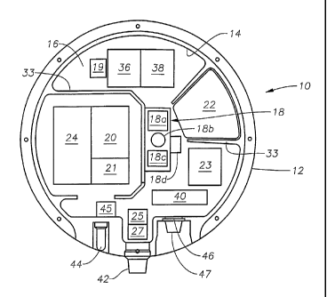
to record data
from the seismic cross-section below the line of receivers. For data over a
larger area and
for three-dimensional representations of a formation, multiple single-line
arrays may be
set out side-by-side, such that a grid of receivers is formed. Often, the
stations and their
receivers are remotely located or spread apart. In land seismic surveys for
example,
hundreds to thousands of receivers, called geophones, may be deployed in a
spatially
diverse manner, such as a typical grid configuration where each line extends
for 5000
meters with receivers spaced every 25 meters and the successive lines are
spaced 500
meters apart.
[04] Generally, several receivers are connected in a parallel-series
combination on a
single twisted pair of wires to form a single receiver group or channel for a
station.
During the data collection process, the output from each channel is digitized
and
recorded for subsequent analysis. In turn, the groups of receivers are usually
connected to cables used to communicate with the receivers and transport the
collected
data to recorders located at a central location, often called the "dog house".
More
specifically, when such surveys are conducted on land, cable telemetry is used
for data
transmission between the individual receivers, the stations and the dog
CA 02554788 2006-07-27
WO 2005/074426 PCT/US2004/030870
house. Other systems use wireless methods for data transmission so that the
individual receivers
and stations are not connected to each other. Still other systems temporarily
store the data at
each station until the data is extracted.
[05] As used throughout this description, "land-based seismic systems" shall
include seismic
systems utilized in costal transition zones such as shallow water or marshes.
With respect to
operation of most land-based seismic systems, the prior art generally requires
some externally
generated control command in order to initiate and acquire data for each shot,
cause stored
seismic data to be transmitted back to the dog house and cause any other data,
such as quality
control data, to be transmitted back to the dog house. Thus the seismic
receiver units must be
either physically connected to the central control recording station or
"connectable" by wireless
techniques. As mentioned above, those skilled in the art will understand that
certain
environments can present extreme challenges for conventional methods of
connecting and
controlling seismic, such as congested or marine environments, rugged mountain
environments
and jungles or remote desert locations. Difficulties may also arise in
instances where the
interconnected, hard-wired receiver array must be periodically moved to cover
a larger area.
[06] Whatever the case, each type of connection, whether via a physical cable
or through
wireless techniques, has its own drawbacks. In cable telemetry systems, large
arrays may result
in large quantities of electrically conductive cabling that are expensive and
difficult to handle,
deploy or otherwise manipulate, as well as repair and maintain. In hostile
environments
characterized by extreme or corrosive conditions, such as salt water, hot,
sandy deserts or
overgrown, damp jungles, costly cable armoring may be required. Furthermore,
conventional
cabling also requires a physical connection between the cable and the sensor
unit. Since it is
generally not practical to hard wire strings of receivers to a cable, the more
conventional
technique is to use external cabling and connectors between strings of
receivers and the telemetry
cable. This point of the connection between the cable and the sensor is
particularly vulnerable to
damage, especially in extreme or corrosive environments. Of course, with
systems that are
physically cabled together, it is much easier to provide power to the
stations/units, to synchronize
data acquisition with the shot time, to perform quality control checks and to
otherwise control the
units.
[07] It should be noted that whether for cabled or wireless systems, the
seismic recording
systems of the prior art separate the receiver package, i.e., the geophones,
from the radio control
package and/or the recording package of the units to the extent the units
provide any on-board
recording. It has heretofore been conventional thinking in the prior art that
geophone coupling
with the earth can be maximized in this way. External cabling is required in
these prior art
Page 2
CA 02554788 2006-07-27
WO 2005/074426 PCT/US2004/030870
systems to connect the geophone Package of a unit with the recording and/or
radio telemetry
packages of the unit. As such, many of the aforementioned drawbacks that arise
from cabling
system units together also exist when cabling various package components of an
individual unit
to one another.
[08] In cases where either wireless technology is utilized or operation of
units and their
sensors is through pre-programming, control and monitoring of the units and
sensors becomes
more difficult. For example, ensuring that recording is synchronized with the
shot timing is
crucial since the individual sensor units are not wired together as described
above. Hence the
need for accurate on-board clocks as mentioned above. In this regard,
activating each unit for
sensing and recording at the appropriate time must coincide with the shot. One
common prior art
technique in this regard is to utilize a command signal sent from the control
station to power up
the system, initiate transmission of data stored from the previous shot and
initiate collection of
data for the current shot which is temporarily written into memory until
transmitted back to the
control station at the time of the next shot.
[09] Ensuring that the units are sufficiently powered has also heretofore been
a concern.
Many prior art patents have focused on techniques and mechanisms for powering
up sensors
during data acquisition/ recording and powering down the sensors during
dormant periods.
[10] A land-based system representative of the prior art is taught in U.S.
Patent No. 6,070,129,
which pertains to the compression and distribution of seismic data from a
plurality of acquisition
units, each unit being suited to acquire, to temporarily store and to compress
the data for
distributed transmission to a central control and recording station. Each
acquisition unit is hard
wired to a plurality of distributed seismic geophones/receivers from which the
acquisition unit
receives data. Each acquisition unit is also disposed to receive operation
instructions from the
central control and recording station. In one embodiment of the invention,
during acquisition of
data from a particular shot, partial data from the previous shot is
transmitted to the central control
and recording station to permit a quality control check and to ensure that the
acquisition units are
properly working. Data from any given shot may be distributed and transmitted
over multiple
transmission channels and during successive transmission windows to lessen
variation in data
flow.
[11] Each of the referenced prior art devices embodies one or more of the
drawbacks of the
prior art. One drawback to these prior art systems is the need to activate and
deactivate the units
for recording and operation, including data and quality control transmission.
For land-based
systems, this generally requires a control signal transmitted via a cable or
radio signal from the
dog house. However, external control may be undesirable since it requires
signal transmission
Page 3
CA 02554788 2006-07-27
WO 2005/074426 PCT/US2004/030870
and additional components in the system. Of course, any type of control signal
cabling for
transmission of electrical signals is undesirable because it adds a level of
complexity to the
handling and control of the unit and requires external connectors or
couplings. Such cabling and
connectors are particularly susceptible to leakage and failure in extreme
environments, whether
the corrosive environment of transition zone water or the high temperature,
corrosive
environments of the desert.
[12] A similar problem exists with units that utilize external electrical
wiring to interconnect
distributed elements of the unit, such as is taught in U.S. Patent No.
5,189,642 and similar
devices where the geophone package is separate from the electronics package.
Furthermore, to
the extent the electronics of a system are distributed, the likelihood of
malfunction of the system
increases.
[13] Many of the prior art systems also use radio telemetry rather than
recording data on-board
the unit, to collect the data. Such systems, of course, have limitations
imposed by the
characteristics of radio transmission, such as radio spectrum license
restrictions, range
limitations, line-of-sight obstructions, antenna limitations, data rate
limitations, power
restrictions, etc.
[14] Thus, it would be desirable to provide a land-based seismic data
collection system that
does not require external communication/power cabling, either from the control
station or on the
seismic data collection unit itself between unit components. Likewise, the
unit should record and
otherwise operate without any type of external control signal. In other words,
the unit should
operate on a "drop and forget" basis. Likewise, the device should be easily
serviced without the
need to open the device to perform activities such as data extraction, quality
control and power
replenishment. The device should also be designed to withstand the corrosive,
extreme
environments which are often encountered in seismic exploration. The device
should also permit
quality control data sent back by radio to determine if the remote units of
the system are
operating properly without the need for control signals or tying the quality
control data
transmission to a shot cycle.
SUMMARY OF THE INVENTION
[15] The present invention provides a land-based system for collecting seismic
data by
deploying multiple, continuous operating, autonomous, wireless, self-contained
seismic
recording units or pods Seismic data previously recorded by the pod can be
retrieved and the
pod can be charged, tested, re-synchronized, and operation can be re-initiated
without the need to
open the pod.
Page 4
CA 02554788 2015-04-24
,
[16] More specifically, the unit is self-contained such that all of the
electronics are disposed
within or on the case, including a geophone package, a seismic data recording
device and a
clock. A power source is either contained within the case, or may be attached
externally to the
case. The clock may be attached to a gimbaled platform having multiple degrees
of freedom
to minimize the effects of gravity on the clock.
[16A] In a broad aspect, the invention pertains to a seismic data
collection unit comprising
a non-spherical case having an external surface. The case has a wall extending
between a first
portion of the external surface and a second portion of the external surface
that defines an
internal, water tight compartment within the case. At least one geophone is
disposed within the
unit, and a clock is disposed within the case. A power source is disposed
within the case, and
a seismic data recorder is comprised of long-term memory disposed within the
case, and capable
of storing seismic reflections from a seismic survey from a series of seismic
shots over an
extended period of time. Any electrical connections between each of the at
least one geophone,
the clock, the power source, and the seismic data recorder are contained
within the unit. The
seismic data recorder is configured to permit seismic signals detected by the
at least one
geophone to be recorded on the seismic data recorder.
[17] In one embodiment of the invention, the clock is a rubidium clock. The
rubidium
clock is much less susceptible to temperature or gravitational effects or
orientation of the unit.
[18] In another embodiment, the unit includes a crystal clock and the
crystal clock is
corrected for the effects of aging on the crystals.
[19] The power source is preferably rechargeable batteries disposed within
the unit's case
that can operate in a sealed environment, such as lithium ion batteries.
Alternatively, the power
source may incorporate a fuel cell or solar cell attached to the unit's case.
Page 5
CA 02554788 2011-06-16
[20] The self-contained seismic units may include a tilt meter within the
unit's case. While
tilt meter data is utilized by the invention for several different inventive
functions, such as the
above-mentioned crystal clock correction procedure, none of the prior art
seismic units have
incorporated a tilt meter within a seismic unit comprising a single, self-
contained package. Rather,
such prior art units have separate attached packages housing the separate
components. For
example, a prior art unit may have one package that houses a tilt meter while
a separate package
houses a geophone.
[21] Of course, a tilt meter may also be used to determine the vertical
orientation of a unit
so that corresponding seismic data can be correct accordingly. One aspect of
the invention
is to obtain and utilize tilt meter data in a time continuous fashion. Prior
art units typically
determine a unit's vertical orientation using means external to said case and
orientation data are
generated therefrom only once at the beginning of seismic recording. To the
extent orientation
corrections have been made to seismic data acquired with each prior art units,
the corrections are
based only on the initial orientation of the unit. Yet it has been observed
that the orientation of
a seismic unit may change over the course of deployment as the unit is subject
to external forces
which have been known to range from water currents to kicking by cows. Thus,
in the invention,
vertical orientation data is measured by the tilt meter as a function of time
so that seismic data
can be correspondingly corrected.
[22] With respect to corrections for tilt, timing or similar data that
could effect the
accuracy of the collected seismic data, all of the prior art devices make such
corrections at a pro-
cessing center. None of the prior art devices make such corrections on-board
the unit while it is
Page 5a
CA 02554788 2006-07-27
WO 2005/074426 PCT/US2004/030870
deployed. Thus, one method of the invention is to make such corrections on-
board the unit while
it is deployed.
[23] The self-contained seismic units of the invention may also include a
compass. Compass
data may be used to provide directional frame of reference data for each
individual unit relative
to the frame of reference for the overall survey. Much like a tilt meter, the
prior art has not
incorporated a compass into a single, self-contained package housing all the
components of the
seismic acquisition unit. To the extent a compass has been incorporated in
prior art seismic
units, the compass has been housed in a separate package from other
components, such as the
geophones. Of course, many prior art units do not determine a unit's
directional orientation at all
and thus do not incorporate a compass. Rather, only vertical orientation data
is acquired using a
tilt meter. When the self-contained multidirectional sensor unit of the
invention incorporates
both a compass used in conjunction with a tilt meter, the specific three
dimensional orientation of
the unit can be determined. None of the prior art devices incorporate the
combination of both a
compass and a tilt meter on board a single, self-contained unit package,
particularly for this
function.
[24] In another aspect of the invention, the unit is activated prior to
transportation out to the
field and deactivated once retrieved, such that it is continuously acquiring
data from before the
time of deployment to after the time of retrieval. Likewise in one embodiment,
the unit begins
recording data prior to deployment. Systems that are activated and begin
recording before
deployment are thereby stabilized prior to the time when signal detection is
desired. This
minimizes the likelihood that an altered state in electronics operation will
disrupt signal detection
and recording or effect clock synchronization.
[25] In another aspect of the invention, the seismic data recording device
includes wrap
around memory and continuously records, even when not in use. This obviates
the need for
initiation or start instructions, ensures that the unit is stabilized at the
desired recording times,
and serves to back-up data from prior recordings until such time as the prior
data is written over.
As long as the clock is synchronized, such a recording device is ready for
deployment at any
time. Furthermore, routine operations such as data collection, quality control
tests and battery
charging can take place without interrupting recording.
[26] Continuous operation is also desirable as an element of an inertial
navigation system
incorporated in the seismic unit and used to measure the unit's x, y and z
position information as
the unit is transported from an initial position, such as a storage location,
to a deployment
position out in the field. An inertial navigation system may include sensors,
such as
accelerometers to track x, y and z position information, as well as a compass
and tilt meter to
Page 6
CA 02554788 2006-07-27
WO 2005/074426 PCT/US2004/030870
determine orientations. Such a system can be used to determine the deployment
location of a
unit in the field.
[27] Each unit may include a communications portal to permit the unit to
interface with a
master control station via the communications portal, typically after the unit
has been retrieved
from deployment. Through the portal, information recorded on the unit can be
downloaded, the
unit batteries can be recharged, quality control checks on the unit can be
conducted, recording
can be re-initiated and the unit can be reactivated without the need to open
or disassemble the
unit.
[28] Each unit may include a unique identification means, such as a radio
frequency
identification (RFID) tag or similar identification indicia to permit tracking
of the individual
units as they are handled. Likewise, each unit may include a Global
Positioning System
("GPS"). Since the individual units are self-contained, the location
information, in association
with the identification indicia allows the units to be randomly handled and
stored, but permits
data from multiple units to be retrieved and sequentially ordered according to
the location of the
unit during a shot cycle. Thus, the need to keep units in sequential order is
obviated. Units that
might have been adjacent one another on a receiver line need not be retrieved
in order or stored
next to one another.
[29] BRIEF DESCRIPTION OF THE DRAWINGS
Fig. 1 is a cut-away top view of the seismic recorder unit of the current
invention.
Fig. 2 is a front side view of the unit of Fig. 1.
Fig. 3 is a back side view of the unit of Fig. 1.
Fig. 4 is a top view of the unit of Fig. 1.
DESCRIPTION OF THE PREFERRED EMBODIMENTS
[30] In the detailed description of the invention, like numerals are employed
to designate like
parts throughout. Various items of equipment, such as fasteners, fittings,
etc., may be omitted to
simplify the description. However, those skilled in the art will realize that
such conventional
equipment can be employed as desired.
[31] With reference to Fig. 1, there is shown a seismic data collection system
or pod 10 of the
invention. Pod 10 is comprised of a case 12 having a wall 14 defining an
internal,
compartment 16. Preferably, case 12 is sealed to prevent water, dust or other
debris from
migrating into compartment 16. Disposed within compartment 16 is at least one
geophone 18, a
clock 20, a power source 22, a control mechanism 23 and a seismic data
recorder 24. In the
embodiment, pod 10 is self-contained such that power source 22 meets all of
the power
Page 7
CA 02554788 2006-07-27
WO 2005/074426 PCT/US2004/030870
requirements of pod 10. Likewise, control mechanism 23 provides all control
functions for
pod 10 eliminating the need for external control communications. In an
alternative embodiment,
power source 22 may be attached externally to case 12 as described below.
[32] Those skilled in the art will appreciate that pod 10 is a self-contained
seismic data
collection system which requires no external communication or control in order
to record seismic
signals. It will be further noted that geophone 18 is internally mounted
within pod 10 and thus
requires no external wiring or connection. It has been determined that
utilizing a compact case
and positioning geophone 18 adjacent the casing wall, geophone 18 can be
effectively coupled to
the earth such that seismic data transmitted through pod 10 to geophone 18 is
not corrupted by
interference. Unless specifically indicated, all references to geophones
utilized in the invention
include conventional geophones as well as other known devices for detecting
seismic wave
activity or directional sensors, including without limitation, accelerometers,
and references to
accelerometers likewise include other directional sensors, including, without
limitation,
geopnones.
[33] In another embodiment of the invention, it has been found advantageous to
utilize four
geophones 18a, 18b, 18c, 18d positioned in a tetrahedral configuration such
that each geophone
measures data in multiple planes. In a standard three dimensions
configuration, three geophones
are positioned 90 apart from each other and each geophone measures signal in
a single x, y or z
plane. In a four geophone configuration, the geophones are oriented
perpendicular to the plane
of the tetrahedral faces so that each geophone measures portions of multiple
planes in the x, y, z
coordinate system. For example, one geophone may measure seismic data in the x-
plane and z-
plane. Geophone configurations of four or more geophones are desirable because
they provide
for redundancy in the seismic unit in the event of failure of a geophone in a
particular plane.
[34] Another embodiment of the invention utilizes a geophone 19 disposed
within pod 10 as a
driven power source to gauge the degree of coupling of pod 10 with the earth.
Those skilled in
the art will understand that the physical coupling between a seismic unit and
the earth has
become one of the primary concerns in the seismic data collection industry.
The invention
incorporates a driven geophone to test this coupling. Specifically, rather
than simply utilizing a
geophone to detect energy, it has been found that a geophone can be utilized
as a power source to
introduce energy, i.e., vibrations, into pod 10. In other words, a geophone
within pod 10 can be
driven thereby causing pod 10 to shake. Such a driven geophone used in
conjunction with the
other geophones on board can be used to determine the degree of physical
coupling between pod
10 and the earth. If pod 10 is well coupled with the earth, the vibrational
energy generated by the
geophone will be transmitted through the pod's coupling structure, such as
spike 52, and
Page 8
CA 02554788 2006-07-27
WO 2005/074426 PCT/US2004/030870
dispersed within the earth. In such case, the other on-board geophones used
for detecting
vibrational energy would detect energy at a first low level. On the other
hand, if there is not
good coupling between pod 10 and the earth, the generated vibrational energy
will not be
transmitted into the earth. In such case, the other on-board geophones used
for detecting
vibrational energy would detect energy at a second level much higher than the
first level.
[35] None of the prior art seismic units teach an on-board system to test
the degree of
coupling between the unit and the earth. This is true in part because none of
the prior art devices
comprise a self-contained seismic recording unit as described herein. Rather,
the prior art units
separate the geophone package from the electronics of the rest of the unit. In
such case, it would
be impractical to include a power source, along with the electronics to
control the power source,
in a distributed, separate geophone package. The above described system is
desirable because it
can be utilized in a system with as few as two geophones, where one geophone
functions as an
energy source and the other geophone functions as an energy receiver. Further,
such a system
permits the use of at least one geophone for a dual purpose, i.e., the
geophone can be used to
generate energy during coupling tests but can otherwise be used in a detection
mode to detect
seismic during seismic exploration. Of course, to the extent a geophone is
dedicated only for use
as an energy source, it need not be positioned with the other seismic
detection geophones in the
unit. Thus, for example, a three geophone package to measure seismic energy in
the x, y and z
planes might be positioned within pod 10 to maximize their ability to detect
seismic energy, such
as adjacent the base of pod 10, while a forth geophone dedicated as an energy
source might be
positioned within pod 10 to maximize distributions of vibrational energy
within pod 10, such as
near the top of pod 10.
[36] In one important aspect of the invention, clock 20 is a rubidium clock.
Heretofore,
rubidium clocks have not been used in seismic exploration due in part to the
expense when
compared to traditional crystal driven clocks. However, because the pod 10 of
the invention is
intended to operate effectively independent of its orientation, it is
necessary to utilize a clock that
in not susceptible to orientation effects which can inhibit operation of
traditional prior art crystal
clocks. Furthermore, rubidium clocks are less susceptible to temperature and
gravitational
effects that can inhibit operation of prior art clocks.
[37] Gravitational effects on clock 20 can also be minimized through use of a
mechanically
gimbaled platform 21 that rotates to maintain clock 20 in a more optimal
orientation for
performance. Preferably, gimbaled platform 21 can rotate in at least three
degrees of freedom,
although gimbaled platform 21 may have fewer degrees of freedom and still be
utilized for the
Page 9
CA 02554788 2006-07-27
WO 2005/074426 PCT/US2004/030870
desired purpose. This is an improvement over prior art seismic units which
have not utilized
gimbaled clock platforms at all.
[38] Unit 10 may also include tilt meter 25. Tilt meter 25 and the data
generated therefrom
may serve several different purposes, including without limitation, correction
of clock data or for
vertical orientation determination. Furthermore, such tilt meter data is
measured as a function of
time. Thus, preferably, the tilt meter data is associated with a data set in a
time continuous
fashion such that a data set generated at a particular time is associated with
tilt meter data
generated at that same time. While prior art seismic units have not
incorporated tilt meters in a
single, self-contained multidirectional sensor unit, to the extent orientation
corrections have been
made to seismic data generated from prior art units, such corrections have
been made from
orientation data generated at the beginning of a shot cycle to correct all of
the seismic data
generated during the shot cycle. This can result in inaccuracies to the extent
the orientation of
the seismic unit is altered during a shot cycle or deployment period. In one
embodiment, all such
tilt meter corrections are made on-board the unit, preferably in real time.
[39] In this same vein, unit 10 may include a compass 27, which, heretofore
has not been
utilized in a single, self-contained multidirectional sensor unit. Compass 27
and the data
generated therefrom may be used to provide directional frame of reference data
for each
individual unit relative to the frame of reference for the overall survey.
Furthermore, when used
in conjunction with tilt meter data, the specific three-dimensional
orientation of a unit can be
determined such that seismic data accuracy can be further improved.
[40] Power source 22 is preferably a lithium ion battery. To the extent prior
art
seismometer systems have utilized on-board batteries, as opposed to external
cabling to supply
power, the prior art batteries have been lead-acid, alkaline or non-
rechargeable batteries. None
of the prior art systems have utilized lithium ion batteries. Furthermore,
because of the sealed,
self-contained nature of the pod of the invention, it is desirable to utilize
a battery that does not
vent fumes, such as a lithium ion type battery. In an alternative embodiment,
power source 22
may incorporate a fuel cell or solar cell attached externally to case 12. Of
course, while such
power source components are not contained within case 12, for purposes of the
invention, pod 10
is still self-contained in the sense that it operates as a stand alone unit
without communication,
control signals or power from a source removed from the pod.
[41] In Figs. 2, 3, and 4, the exterior of pod 10 is shown. Wall 14 defining
case 12 may
include a first plate 26 and a second plate 28 jointed together along their
peripheries by a portion
of wall 14. Each plate defines an external surface 50. While plates 26 and 28
are disk shaped in
the illustrated embodiment such that pod 10 has an overall wheel shape, pod 10
can be of any
Page 10
CA 02554788 2006-07-27
WO 2005/074426 PCT/US2004/030870
shape so long as it functions in accordance herewith. The external surface 50
may be provided
with projections 51, such as ridges or grooves, to enhance coupling between
pod 10 and the
earth. In the embodiment shown in Fig. 4, the projections 51 form a chevron
pattern on surface
50. More pronounced projections, such as spikes 52, may be provided to prevent
movement of
pod 10 once it is deployed and improve coupling.
[42] Each unit may include a unique identification means, such as a radio
frequency
identification (RFID) tag 40 or similar identification indicia to permit
tracking of the individual
units as they are handled during deployment and retrieval. Likewise, each unit
may include a
GPS transducer 42 which permits the unit's location to be determined (to the
extent a unit is
deployed in a location in which GPS is effective).
[43] Fig. 1 also shows a radio antennae 44 which is communication with a radio
unit 45
disposed within case 12.
[44] A connector 46 for permitting communication with pod 10 may also be
disposed on case
12. Such communication may occur when pod 10 is in storage at a central
command unit or even
to the extent data is simply retrieved by an operator who travels out to the
pod's deployment
location. Connector 46 may be a standard pin connector or may be an infrared
or similar
connector that requires no hard wiring in order to communicate with pod 10.
Via connector 46,
pod 10 may be serviced without removing one of plates 26, 28 or otherwise
opening case 12.
Specifically, connector 46 permits quality control tests to be run, recorded
seismic data to be
extracted, clock 20 to be synchronized and power source 22 to be recharged. A
sealing
connector cap 47 may also be provided to protect connector 46. For under water
uses or other
wet environments, connector cap 47 is preferably water tight. Utilizing such a
connector cap 47,
connector 46 may be any standard connector that satisfies the desired
functions of the pod and
need not be of the type normally required of external connectors subjected to
extreme or
corrosive environments.
[45] One function of the seismic data recording unit of the invention is the
continuous
operation of the unit. In this aspect of the invention, data acquisition is
initiated prior to
positioning of the unit on the earth's surface, i.e., prior to deployment. For
example, units may
be activated at a central location prior to trucking them out to the field.
Systems that are
activated and begin acquiring data prior to deployment are thereby stabilized
prior to the time
synchronization and seismic data recording are desired. This minimizes the
likelihood that an
altered state in electronics operation will have an effect of data integrity.
[46] In a similar embodiment, data recording is initiated prior to positioning
along a receiver
line. Again, this permits units to stabilize prior to the time synchronization
and seismic data
Page 11
CA 02554788 2006-07-27
WO 2005/074426 PCT/US2004/030870
recording are desired. To this end, one component of system stabilization is
clock stabilization.
Of the various components of the system, it is well known that clocks
typically take a long time
to stabilize. Thus, in one embodiment of the invention, whether the unit is
continuously
detecting data or continuously recording data, the clock always remains on.
[47] In either of the preceding two methods, the unit can be utilized in
several cycles of
deployment and retrieval without interrupting the continuous operation of the
unit. Thus, for
example, prior to deployment, recording is initiated. The device is deployed,
retrieved and
redeployed, all while recording is continued. As long as memory is sufficient,
this continuous
recording during multiple cycles of deployment and redeployment can be
maintained.
[48] In this regard, to the extent the seismic data unit includes wrap around
memory, it can
continuously record even when not in use in seismic detection. Thus, in
addition to the
advantages described above, initiation or start instructions become
unnecessary. Further,
continuous recording utilizing wrap around memory functions as a back-up for
data acquired
from prior recordings until such time as the prior data is written over. An
additional advantage is
that the device is ready for deployment at any time as long as the clock is
synchronized.
[49] To the extent recording is continued after a unit has been retrieved,
routine operations
such as data retrieval, quality control tests and battery charging can take
place without
interrupting recording. One benefit of such a system is that the device can be
utilized to record
quality control test data rather than seismic data when conducting quality
control tests. In other
words, the data input changes from seismic data to quality control data. Once
quality control is
complete, the device may resume recording seismic data or other desired data,
such as data
related to position and timing.
[50] While "continuous" unit operation has been described temporally in one
embodiment as
setting operation parameters to initiate operation prior to deployment of the
unit, for purposes of
the meaning of "continuous" as used herein, the time period of unit operation
may simply be
initiated prior to a shot and continue through a series of shots or shot
cycles and may also include
continued recording of a unit through a series of shots or shot cycles. In
another embodiment,
while continuously operating, parameters may be set to intermittently record
at pre-set, specified
times.
[51] The above described continuous operation of the seismic units of the
invention is
particularly suited for use with a unique position determination method of the
invention.
Specifically, a unit's x, y and z position information is recorded as the unit
is transported from an
initial position, such as a storage location, to a deployment position out in
the field. The
positional information may be determined using an inertial navigation system
that measures
Page 12
CA 02554788 2006-07-27
WO 2005/074426 PCT/US2004/030870
movement in each of the x, y and z dimensions as well as angular movement
around each x, y
and z axis. In other words, the system measures the six degrees of freedom of
the unit as it
travels from the initial location to the deployment position, and utilizes
such measurement
information to determine the location of the deployment position. In the
preferred embodiment,
such x, y and z dimensional information can be determined utilizing
accelerometers. Angular
orientation, i.e., tilt and direction, information can be determined utilizing
a tilt meter and a
compass or other orientation devices, such as gyroscopes. In one embodiment of
the invention,
three accelerometers and three gyroscopes are utilized to generate the
inertial navigation data
used to determine the unit's deployment position.
[52] In any event, by combining accelerometer and the tilt and direction
orientation
information as a function of time with the unit's initial position and
velocity at the time of initial
deployment, the travel path of the unit and hence the deployment location of
the unit, can be
determined. Time sampling will occur at appropriate intervals to yield the
accuracy needed.
Time sampling between various measurement components may vary. For example,
data from the
compass, used to measure direction, and the tilt meter, used to measure tilt,
may be sampled
more slowly than data from the accelerometers. Heretofore, no other seismic
unit has utilized
one or more accelerometers to determine location in this way. In this regard,
the method and
system replaces the need to determine location utilizing other techniques,
such as through GPS or
the like.
[53] Because a unit is already recording data at the time of its
transportation to and
deployment in the field, x, y and z positional information is easily recorded
on the unit and
becomes part of the unit's complete data record.
[54] To the extent clock 20 is a crystal clock, one method of the invention is
to make clock
corrections to compensate for aging of the clock's crystals. Specifically, it
has been determined
that seismic data can be effected by the aging of crystals within a unit's
crystal clock.
[55] Typically, the aging curve for a given crystal will be logarithmic for an
initial period of
time and gradually transition into a more linear curve over an extended period
of time. As such,
the curve has a significant slope at the beginning of the aging process and a
more linear, flat
slope at as the aging process continues over time. In this regard, a seismic
unit will tend to have
more crystal aging at the beginning of a deployment period. In any event,
prior to deployment, a
characterization curve for a clock's crystal can be determined by plotting
crystal aging vs. time
over an extended period of days, such as fifteen to twenty days. In operation,
the crystal
frequency can be measured at the time of deployment and at the end of
deployment. Utilizing
Page 13
CA 02554788 2014-01-28
this information, the applicable portion of the aging curve can be identified
and the seismic data
collected over the period can be adjusted accordingly.
[56] Of course, one process to minimize the effects of crystal aging is to
preage a clock's
crystals prior to deployment of the unit. This is somewhat equivalent to
initiating operation of
the unit prior to deployment in order to permit the unit to stabilize as
described above. By
preaging crystals, the exponential portion of the characterization curve can
be voided such that
the correction information is simply linear in nature. In other words,
preaging stabilizes the
aging slope and simplifies seismic data corrections for crystal aging.
[57] In this regard, each time a seismic unit is powered off and back on,
the clock's crystals
must be re-characterized. However, over multiple cycles of operation, the
linear portion of the
aging curve, i.e., crystal aging stabilization, is reached more quickly.
Notwithstanding the
foregoing, whether crystals are preaged or not, none of the prior art devices
or seismic data
processing techniques correct for crystal aging as described herein.
[58] The scope of the claims should not be limited by the preferred
embodiments set forth
in the description, but should be given the broadest interpretation consistent
with the description
as a whole.
Page 14