Note: Descriptions are shown in the official language in which they were submitted.
CA 02554937 2006-08-O1
FIELD OF THE INVENTION
[0001] The present invention relates generally to an apparatus for logging a
subterranean borehole. More specifically, this invention relates to a
measurement tool for
making substantially real time tool face angle measurements on a rotating
drill collar. By
linking such measurements to contemporaneously obtained real time measurements
of
certain formation properties, the azimuthal variation of the measured property
may be
determined. In this manner, an image of the measured property within the
borehole may
be developed. The present invention, therefore, relates specifically to a tool
and method
for obtaining and processing the real time tool face angle measurements
required for
borehole imaging applications.
BACKGROUND OF THE INVENTION
[0002] Wireline and logging while drilling (LWD) tools measure physical
properties of
the formations through which a borehole traverses. Such logging techniques
include, for
example, natural gamma ray, spectral density, neutron density, inductive and
galvanic
resistivity, acoustic velocity, acoustic calliper, downhole pressure, and the
like.
Formations having recoverable hydrocarbons typically include certain well-
known
physical properties, for example, resistivity, porosity (density), and
acoustic velocity
values in a certain range. In some logging applications it is desirable to
determine the
azimuthal variation of particular formation properties (i.e., the extent to
which such
properties vary about the circumference of the borehole). Such information may
be
utilized, for example, to locate faults and dips that may occur in the various
layers that
make up the strata. Tools capable of producing azimuthally sensitive
information on
formation properties are typically identified as imaging tools.
2
' CA 02554937 2006-08-O1
~ '
[0003] Downhole imaging tools have been available in wireline form for some
time.
Such wireline tools typically create images by sending large quantities of
circumferentially sensitive logging data uphole via a high-speed data link
(e.g., a cable).
Further, such wireline tools are typically stabilized and centralized in the
borehole and
include multiple (often times one hundred or more) sensors (e.g., resistivity
sensors)
extending outward from the tool into contact (or near contact) with the
borehole wall. It
will be appreciated by those of ordinary skill in the art that such wireline
arrangements
are not suitable for typical LWD applications. In particular, communication
bandwidth
with the surface would typically be insufficient during LWD operations (e.g.,
via known
telemetry techniques) to carry large amounts of image-related data. Further,
LWD tools
are generally not centralized or stabilized during operation and thus require
more rugged
sensor arrangements.
[0004] Several attempts have been made to develop LWD tools and methods that
may
be used to provide images of various circumferentially sensitive sensor
measurements
related to borehole andlor formation properties. Many such attempts have made
use of
the rotation of the BHA (and therefore the LWD sensors) during drilling of the
borehole.
For example, Holenka et al., in U.S. Patent 5,473,158, discloses a method in
which sensor
data (e.g., neutron count rate) is grouped by quadrant about the circumference
of the
borehole. Kurkoski, in U.S. Patent 6,584,837, and Spross, in U.S. Patent
6,619,395,
disclose similar methods.
[0005] In prior art methods, conventional flux gate magnetometers are utilized
to
determine the tool face angle of the LWD sensor (which, as described in more
detail
below, is often referred to in the art as sensor azimuth) at the time a
particular
3
CA 02554937 2006-08-O1
~ i
measurement or group of measurements are obtained by the sensor. While flux
gate
magnetometers (also referred to in the art as ring core magnetometers) can be
used in
borehole surveying applications, such magnetometers have some characteristics
that are
not ideally suited to imaging applications. For example, flux gate
magnetometers
typically have a relatively limited bandwidth (e.g., about 5 Hz). Increasing
the bandwidth
requires increased power to increase the excitation frequency at which
magnetic material
is saturated and unsaturated. In LWD applications, electrical power is often
supplied by
batteries, making such power a somewhat scarce resource. For this reason,
increasing the
bandwidth of flux gate magnetometers beyond about 5 Hz is not practical in
many LWD
applications. Flux gate magnetometers, therefore, are not well suited for
making
substantially real-time tool face angle measurements in many LWD settings.
There exists
a need for sensors and/or sensor arrangements that are suitable for making
such real time
tool face angle measurements.
[0006] Flux gate magnetometers are sensitive instruments requiring careful
calibration
and handling. Though magnetometers have been used in many LWD and MWD tools,
these instruments present design challenges that add to the complexity and
expense of the
tools. The magnetometers are also relatively expensive, which further
compounds this
problem. A need exists, therefore, for a more simple, more rugged, and lower
cost means
for providing substantially real-time azimuthal information in LWD imaging
applications.
[0007] Moreover, AC and/or DC power is often routed through a drill collar
(e.g., from
a turbine or a battery pack) to an LWD sensor. The magnetic field about the
electrical
transmission line is known to interfere with nearby magnetometers. While AC
fields may
be filtered in certain applications, DC fields are particularly difficult to
accommodate.
4
CA 02554937 2006-08-O1
There also exists a need for an arrangement suitable for routing electrical
power past
magnetic field sensors deployed on a drill collar.
SUMMARY OF THE INVENTION
[0008] The present invention addresses one or more of the above-described
drawbacks
in prior art apparatuses used to measure tool face angles on a rotating drill
collar.
Exemplary embodiments of this invention include a measurement tool having a
tri-axial
arrangement of magnetoresistive magnetic field sensors deployed therein. The
magnetoresistive sensors are configured to make substantially real time
magnetic field
measurements (e.g., at 10 millisecond intervals). Embodiments of the tool
further include
a programmed processor configured to calculate tool face angles from the
magnetic field
measurements. The processor may be further configured to correlate the
calculated tool
face angles with contemporaneously obtained logging while drilling data for
use in
constructing a borehole image of a formation property.
[0009] Exemplary embodiments of the present invention may advantageously
provide
several technical advantages. For example, embodiments of this invention
advantageously enable tool face angles to be measured in substantially real
time on a
rotating drill collar. As such, embodiments of this invention may be utilized
in
conjunction with circumferentially sensitive LWD tools to form borehole images
having
improved circumferential sensitivity. Embodiments of the present invention
also provide
a less expensive and potentially more rugged means of obtaining real-time tool
face angle
information. Moreover, in exemplary embodiments of this invention, the
magnetic field
sensors are deployed to advantageously minimize or even substantially
eliminate
CA 02554937 2006-08-O1
magnetic interference due to the transmission of electrical power through the
tool, thereby
improving the accuracy of the calculated tool face angles.
[0010] In one aspect the present invention includes a borehole imaging tool.
The tool
includes a tool body configured for rotating with a drill string in a
subterranean borehole
and at least one magnetoresistive magnetic field sensor deployed in the tool
body. The
magnetoresistive sensor is disposed to measure first and second cross axial
components of
a magnetic field in the subterranean borehole. The tool further includes a
programmed
processor communicatively coupled with the at least one magnetoresistive
magnetic field
sensor. The programmed processor is configured to (i) calculate tool face
angles in
substantially real time from the cross axial components of the magnetic field,
(ii) receive
logging while drilling data from a logging while drilling sensor, and (iii)
correlate the
logging while drilling data and the tool face angles into a set of
corresponding data pairs
for use in constructing a borehole image of a formation property.
[0011] In another aspect, this invention includes a borehole imaging. The tool
includes
a tool body configured for rotating with a drill string in a subterranean
borehole, at least
one magnetoresistive magnetic field sensor deployed in the tool body, and at
least one
logging while drilling sensor deployed in the tool body. The magnetoresistive
sensor is
disposed to measure first and second cross axial components of a magnetic
field in the
subterranean borehole, while the logging while drilling sensor is disposed to
make
formation property measurements in the subterranean borehole. The tool further
includes
a programmed processor communicatively coupled with the at least one
magnetoresistive
magnetic field sensor and the at least one logging while drilling sensor. The
programmed
processor is configured to calculate tool face angles of the at least one
logging while
6
CA 02554937 2006-08-O1
drilling sensor in substantially real time from the cross axial components of
the magnetic
field.
[0012] In a further aspect, this invention includes a downhole measurement
tool. The
measurement tool includes a tool body configured to be operatively coupled
with a drill
string and deployed in a subterranean borehole. The measurement tool further
includes
an electrical transmission path for conducting electrical power from one
longitudinal end
of the tool to another longitudinal end thereof. The transmission path
includes an
electrically conductive, non-magnetic tube, deployed in the tool body. At
least one
magnetic field sensor is deployed in the conductive tube.
[0013] The foregoing has outlined rather broadly the features and technical
advantages
of the present invention in order that the detailed description of the
invention that follows
may be better understood. Additional features and advantages of the invention
will be
described hereinafter, which form the subject of the claims of the invention.
It should be
appreciated by those skilled in the art that the conception and the specific
embodiments
disclosed may be readily utilized as a basis for modifying or designing other
structures for
carrying out the same purposes of the present invention. It should also be
realized by
those skilled in the art that such equivalent constructions do not depart from
the spirit and
scope of the invention as set forth in the appended claims.
BRIEF DESCRIPTION OF THE DRAWINGS
[0014] For a more complete understanding of the present invention, and the
advantages
thereof, reference is now made to the following descriptions taken in
conjunction with the
accompanying drawings, in which:
7
CA 02554937 2006-08-O1
[0015] FIGURE 1 is a schematic representation of an offshore oil and/or gas
drilling
platform utilizing an exemplary embodiment of a downhole measurement tool
according
to the present invention.
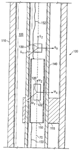
[0016] FIGURE 2 depicts, in longitudinal cross section, a portion of downhole
measurement tool shown on FIGURE 1.
[0017] FIGURE 3 depicts an exemplary electrical block diagram of a tri-axial
arrangement of magnetic field sensors and a tri-axial arrangement of gravity
sensors.
[0018] FIGURE 4 depicts an exemplary circuit diagram of the tri-axial
arrangement of
magnetic field sensors shown on FIGURE 3.
DETAILED DESCRIPTION
[0019] Before proceeding with a discussion of the present invention, it is
necessary to
make clear what is meant by "azimuth" as used herein. The term azimuth has
been used
in the downhole drilling art in two contexts, with a somewhat different
meaning in each
context. In a general sense, an azimuth angle is a horizontal angle from a
fixed reference
position. Mariners performing celestial navigation used the term, and it is
this use that
apparently forms the basis for the generally understood meaning of the term
azimuth. In
celestial navigation, a particular celestial object is selected and then a
vertical circle, with
the mariner at its center, is constructed such that the circle passes through
the celestial
object. The angular distance from a reference point (usually magnetic north)
to the point
at which the vertical circle intersects the horizon is the azimuth. As a
matter of practice,
the azimuth angle was usually measured in the clockwise direction.
[0020] In this traditional meaning of azimuth, the reference plane is the
horizontal plane
tangent to the earth's surface at the point from which the celestial
observation is made. In
8
CA 02554937 2006-08-O1
other words, the mariner's location forms the point of contact between the
horizontal
azimuthal reference plane and the surface of the earth. This context can be
easily
extended to a downhole drilling application. A borehole azimuth in the
downhole drilling
context is the relative bearing direction of the borehole at any particular
point in a
horizontal reference frame. Just as a vertical circle was drawn through the
celestial object
in the traditional azimuth calculation, a vertical circle may also be drawn in
the downhole
drilling context with the point of interest within the borehole being the
center of the circle
and the tangent to the borehole at the point of interest being the radius of
the circle. The
angular distance from the point at which this circle intersects the horizontal
reference
plane and the fixed reference point (e.g., magnetic north) is referred to as
the borehole
azimuth. And just as in the celestial navigation context, the azimuth angle is
typically
measured in a clockwise direction.
[0021] It is this meaning of "azimuth" that is used to define the course of a
drilling
path. The borehole inclination is also used in this context to define a three-
dimensional
bearing direction of a point of interest within the borehole. Inclination is
the angular
separation between a tangent to the borehole at the point of interest and
vertical. The
azimuth and inclination values are typically used in drilling applications to
identify
bearing direction at various points along the length of the borehole. A set of
discrete
inclination and azimuth measurements along the length of the borehole is
further
commonly utilized to assemble a well survey (e.g., using the minimum curvature
assumption). Such a survey describes the three-dimensional location of the
borehole in a
subterranean formation.
9
CA 02554937 2006-08-O1
[0022] A somewhat different meaning of "azimuth" is found in some borehole
imaging
art. In this context, the azimuthal reference plane is not necessarily
horizontal (indeed, it
seldom is). When a borehole image of a particular formation property is
desired at a
particular point with the borehole, measurements of the property are taken are
points
around the circumference of the measurement tool. The azimuthal reference
plane in this
context is the plane centered at the measurement tool and perpendicular to the
longitudinal direction of the borehole at that point. This plane, therefore,
is fixed by the
particular orientation of the borehole measurement tool at the time the
relevant
measurements are taken.
[0023] An azimuth in this borehole imaging context is the angular separation
in the
azimuthal reference plane from a reference point to the measurement point. The
azimuth
is typically measured in the clockwise direction, and the reference point is
frequently the
high side of the borehole or measurement tool, relative to the earth's
gravitational field,
though magnetic north may be used as a reference direction in some situations.
Though
this context is different, and the meaning of azimuth here is somewhat
different, this use
is consistent with the traditional meaning and use of the term azimuth. If the
longitudinal
direction of the borehole at the measurement point is equated to the vertical
direction in
the traditional context, then the determination of an azimuth in the borehole
imaging
context is essentially the same as the traditional azimuthal determination.
[0024] Another important label used in the borehole imaging context is the
"tool face
angle". When a measurement tool is used to gather azimuthal imaging data, the
point of
the tool with the measuring sensor is identified as the "face" of the tool.
The tool face
angle, therefore, is defined as the angular separation from a reference point
to the radial
CA 02554937 2006-08-O1
direction of the tool face. The assumption here is that data gathered by the
measuring
sensor will be indicative of properties of the formation along a line or path
that extends
radially outward from the tool face into the formation. The tool face angle is
an azimuth
angle, where the measurement line or direction is defined for the position of
the tool
sensors. In the remainder of this document, the terms azimuth and tool face
angle will be
used interchangeably, though the tool face angle identifier will be used
predominantly.
[0025] Turning now to FIGURE 1, one exemplary embodiment of a measurement tool
100 in accordance with this invention in use in an offshore oil or gas
drilling assembly,
generally denoted 10, is schematically illustrated. In FIGURE 1, a
semisubmersible
drilling platform 12 is positioned over an oil or gas formation (not shown)
disposed below
the sea floor 16. A subsea conduit 18 extends from deck 20 of platform 12 to a
wellhead
installation 22. The platform may include a dernck 26 and a hoisting apparatus
28 for
raising and lowering the drill string 30, which, as shown, extends into
borehole 40 and
includes a drill bit 32 and a measurement tool 100. In the exemplary
embodiment shown,
measurement tool 100 is deployed between an electrical power sub 200 and a
logging
while drilling (LWD) tool 250. Power sub 200 may include, for example, a
battery pack
or alternatively a turbine for converting the flow of drilling fluid into AC
power. In the
exemplary embodiment shown, electrical power is transmitted through
measurement tool
100 to LWD tool 250 via one or more transmission lines (not shown).
[0026] Measurement tool 100 includes at least one magnetic field sensor 120.
Measurement tool 100 may also further include one or more accelerometers
and/or
gyroscopes. As described in more detail below with respect to FIGURE 2,
magnetic field
11
CA 02554937 2006-08-O1
sensor 120 typically includes at least one magnetoresistive magnetic field
sensor
deployed on or near the longitudinal axis of measurement tool 100.
[0027] LWD tool 250 typically includes at least one LWD sensor 260 deployed
thereon. Such LWD sensors may include substantially any downhole logging
sensors, for
example, including a natural gamma ray sensor, a neutron sensor, a density
sensor, a
resistivity sensor, a formation pressure sensor, an annular pressure sensor,
an ultrasonic
sensor, an audio-frequency acoustic sensor, and the like. While the embodiment
shown
on FIGURE 1, includes a measurement tool 100 deployed adjacent to electrical
power sub
200 and LWD tool 250, it will be appreciated that the invention is not limited
in this
regard.
[0028] It will be understood by those of ordinary skill in the art that the
deployment
illustrated on FIGURE 1 is merely exemplary for purposes of describing the
invention set
forth herein. It will be further understood that the measurement tool 100 of
the present
invention is not limited to use with a semisubmersible platform 12 as
illustrated on
FIGURE 1. Measurement tool 100 is equally well suited for use with any kind of
subterranean drilling operation, either offshore or onshore.
[0029] Referring now to FIGURE 2, a portion of one exemplary embodiment of
measurement tool 100 from FIGURE 1 is schematically illustrated. Measurement
tool
100 is typically a substantially cylindrical tool, being largely symmetrical
about
longitudinal axis 70. Measurement tool 100 includes a tool body 110 configured
for
coupling to a drill string (e.g., drill string 30 on FIGURE 1) and therefore
typically, but
not necessarily, includes conventional threaded pin and/or box ends (not
shown).
Measurement tool 100 further includes a pressure housing 140 deployed
substantially
12
CA 02554937 2006-08-O1
coaxially in the tool body 110. The outer diameter of pressure housing 140 is
typically
less than the inner diameter of tool body 110, thereby providing an annular
region 105 for
the flow of drilling fluid downhole, for example, to a drill bit assembly
(e.g., drill bit 32
on FIGURE 1 ). In the exemplary embodiment shown in FIGURE 2, a plurality of
stabilizer fins 115 extend radially outward from pressure housing 140 into
contact with an
inner surface of the tool body 110. The stabilizer fins 115 are intended to
stabilize and
center the pressure housing 140 substantially coaxially in the tool body 110.
[0030] As described above with respect to FIGURE 1, electrical power may be
routed
through measurement tool 100 (e.g., from power sub 200 to LWD tool 250 as
shown on
FIGURE 1 ). In the exemplary embodiment shown, the electrical power is routed
from the
power sub 200 through conductor 152, electrically conductive tube 150, and
conductor
153 to the LWD tool 250. Tube 150 is deployed substantially coaxially in the
pressure
housing 140 (although the invention is not limited in this regard) and may be
fabricated
from substantially any electrically conductive, non magnetic material, such
as, but not
limited to, copper, copper alloys (e.g., including brass and bronze),
aluminum, and
aluminum alloys. Measurement tool 100 further includes a magnetic field sensor
120
deployed in the conductive tube 150. Such an arrangement is intended to
minimize
magnetic interference from the transmission of the electrical current through
the
measurement tool 100.
[0031] It will be appreciated that according to Ampere's law, there is
essentially no
magnetic field inside a hollow conductor due to electrical current in the
conductor.
Ampere's law states that the integral of the magnetic field about any closed
loop path is
13
CA 02554937 2006-08-O1
equal to the magnetic permeability times the electric current enclosed in the
loop. This
may be expressed mathematically as follows:
c~Bdl = ~LlOlenclosd Equation 1
[0032] where B represents the magnetic field, ,uo represents the magnetic
permeability, and len~ros~r represents the electrical current closed in the
loop. The
cylindrical symmetry of tube 150 requires that the magnetic field B is
essentially
constant about any circle whose center is coaxial with the tube 150. The
magnetic field
may therefore be removed from the integral yielding:
Bc~dl = flOlenclosd Equation 2
[0033] Since the electrical current enclosed in a circular path just inside
the inner wall
of the tube 150 is essentially zero ( Ienclosd = 0 due to the lack of a
conducting medium),
the magnetic field due to the electrical current in the tube must also be
essentially zero.
As such, an electric current passing through the conductive tube 150 (e.g.,
from power
sub 200 to LWD tool 250) creates substantially no magnetic interference inside
the tube
150. Therefore, the effect of magnetic interference from electrical currents
in the tool
may be advantageously minimized (or even substantially eliminated) via
deployment of
the magnetic field sensors 120 inside the conductive tube 150.
[0034] Magnetic field sensor 120 may include substantially any sensor suitable
for
obtaining tool face angles on a rotating drill collar, such as magnetometers
or magneto-
resistive sensors (either giant magneto-resistive (GMR) sensors or anisotropic
magneto
resistive (AMR) sensors may be used). In the exemplary embodiment shown,
measurement tool 100 includes a tri-axial arrangement Mx, My, and Mz of GMR
sensors
14
CA 02554937 2006-08-O1
deployed in tube 150. Such a tri-axial arrangement, in which one of the
sensors has a
known orientation relative to longitudinal axis 70 (in the exemplary
embodiment shown
on FIGURE 2 Mz is substantially parallel with longitudinal axis 70),
advantageously
enables the magnetic field to be resolved into a magnetic field vector (having
magnitude
and direction components).
[0035] With continued reference to FIGURE 2, exemplary embodiments of
measurement tool 100 may also include a tri-axial arrangement Gx, Gy, and Gz
of gravity
sensors 130 deployed therein, although the invention is not limited in this
regard. In the
exemplary embodiment show, the gravity sensors 130 are deployed adjacent
electrically
conductive tube 150 and substantially on the longitudinal axis 70 of the tool
100. It will
be appreciated that gravity sensors 130 may be equivalently deployed in the
conducting
tube 150 along with the magnetic field sensors 120 or elsewhere in the drill
string (e.g., in
a MWD tool deployed elsewhere in drill string 30 on FIGURE 1).
[0036] With reference now to FIGURES 3 and 4, magnetic field sensors 120 and
gravity sensors 130 are described in more detail. FIGURE 3 illustrates an
electrical block
diagram of a tri-axial arrangement of magnetic field sensors 120x, 120y, and
120z and a
tri-axial arrangement of gravity sensors 130x, 130y, and 130z. In the
exemplary
embodiment shown on FIGURE 3, tri-axial magnetic field sensors 120x, 120y, and
120z
are mounted on an electronic circuit board (e.g., as shown schematically at
122 on
FIGURE 2). The outputs of the magnetic field sensors 120x, 120y, and 120z and
gravity
sensors 130x, 130y, and 130z are electronically coupled to corresponding
inputs of a
mufti-channel analog to digital (A/D) converter 170, which digitizes the
analog
components of the magnetic field. In one exemplary embodiment, A/D converter
170
CA 02554937 2006-08-O1
includes two 16-bit A/D converters, each including 4 input channels, such as
the AD7654
available from Analog Devices, Inc. (Norwood, Massachusetts). It will be
appreciated
that the invention is not limited in this regard as substantially any suitable
A/D converter
may be utilized.
[0037] The magnetic field and gravity sensors referred to herein are
preferably chosen
from among commercially available sensor devices known in the art. Suitable
accelerometer packages include, for example, Part Number 979-0273-001
commercially
available from Honeywell, and Part Number JA-5H175-1 commercially available
from
Japan Aviation Electronics Industry, Ltd. (JAE). As described in more detail
below,
suitable magnetic field sensors include magnetoresistive sensors, for example,
Part
Number HMC-1021D, available from Honeywell.
[0038] In the exemplary embodiment shown, A/D converter 170 is electronically
coupled to a microprocessor, for example, via a 16-bit bus. Substantially any
suitable
microprocessor may be utilized, for example, including an ADSP-2191M
microprocessor,
available from Analog Devices, Inc. It will be understood that while not shown
in
FIGURES 1 through 4, embodiments of this invention may include an electronic
controller. Such a controller may include, for example, microprocessor 180 and
A/D
converter 170, along with volatile or non-volatile memory, and/or a data
storage device.
The controller may also include processor-readable or computer-readable
program code
embodying logic, including instructions for continuously computing tool face
angles in
substantially real time during rotation of measurement tool 100 in a borehole.
Such
instructions may include, for example, the algorithms set forth below. The
controller may
further include instructions for computing borehole inclination and azimuth
from gravity
16
CA 02554937 2006-08-O1
and magnetic field measurements. In such exemplary embodiments, measurement
tool
100 essentially functions as a measurement while drilling survey tool.
Moreover, the
controller may include a number of look-up tables for solving the
trigonometric functions
employed in such algorithms.
[0039] A suitable controller may also optionally include other controllable
components,
such as sensors, data storage devices, power supplies, timers, and the like.
The controller
may also be disposed to be in electronic communication with various sensors
and/or
probes for monitoring physical parameters of the borehole. For example, the
controller
may be disposed to communicate with LWD tool 250 shown on FIGURE 1. In this
manner, circumferentially sensitive LWD measurements may be correlated with
real time
tool face angle measurements. A suitable controller may also optionally
communicate
with other instruments in the drill string, such as telemetry systems that
communicate
with the surface. The artisan of ordinary skill will readily recognize that a
suitable
controller may be deployed substantially anywhere within the measurement tool
or at
another suitable location in the drill string (e.g., in LWD tool 250).
[0040] Turning now to FIGURE 4, a schematic circuit diagram of exemplary
magnetic
field sensors 120x, 120y, and 120z is illustrated. In this configuration, each
of the
magnetic field sensors 120x, 120y, 120z includes a magnetoresistive bridge 125
mounted,
for example on a conventional circuit board (such as circuit board 122 shown
on FIGURE
2) and coupled to a constant current power source 127. The output signal from
each
magnetoresistive bridge 125 is amplified via a conventional amplifier circuit
128, the
output of which is digitized as described above with respect to FIGURE 3.
17
CA 02554937 2006-08-O1
[0041] The magnetoresistive elements are typically made from a nickel-iron
(permalloy) thin film deposited on a silicon wafer and patterned as a
resistive strip. In the
presence of a magnetic field, a change in the bridge 125 resistance causes a
corresponding
change in voltage output. The change in the bridge 125 resistance is referred
to as the
magnetoresistive effect and is directly related to the current flow in the
bridge 125 and the
magnitude and direction of the magnetic field (the magnetic field vector).
Suitable
magnetoresistive sensors include, for example, part number HMC-1021D,
available from
Honeywell (Plymouth, Minnesota).
[0042] With continued reference to FIGURE 4, exemplary embodiments of the
magnetoresistive sensor 120x, 120y, 120z include a set reset strap 123. Prior
to use the
sensors are typically "set" by application of high current pulse to the reset
strap 123. The
current pulse generates a strong enough magnetic field to align the magnetic
domains in
the magnetoresistors. This ensures a highly sensitive and repeatable sensor
state. A
negative current pulse (a pulse in the opposite direction) may be utilized to
"reset" the
sensor in the opposite direction (align the magnetic domains in the opposite
direction).
[0043] In one exemplary method embodiment, measurement tool 100 (FIGURES 1 and
2) is coupled to a drill string and rotated in a borehole. The sensors may be
"set" prior to
measurement of a magnetic field by application of a high current pulse to
reset strap 123
as described above. The sensor output is then averaged, for example, for about
5
milliseconds. A reset pulse is then applied (as described above), reversing
the magnetic
domain alignment of the magnetoresistive element (and consequently the bridge
output
signal polarity). A second sensor output is then averaged, for example, for an
additional 5
milliseconds. The controller (not shown) may then calculate a sum and/or a
difference of
18
CA 02554937 2006-08-O1
the two sets of measurements in order to account for the bridge offset. In
order to
maximize the analog input range of A/D converter 170 in subsequent
measurements, an
offset nulling voltage may be applied to an input of amplifier 128, as known
to those of
ordinary skill in the art. In a typical downhole environment, for example, in
which the
temperature and pressure are subject to continuous change, the bridge offset
may be
determined as frequently as required (e.g., several times per minute if
necessary).
[0044] In the exemplary method embodiment described above, a tri-axial set of
magnetic field measurements may be obtained, for example, at 10 millisecond
intervals.
For a drill collar rotating at 200 rpm, tool face angles may be determined 30
times per
revolution (i.e., at 12 degree intervals). It will be understood that the
invention is
expressly not limited in this regard, since magnetic field measurements may be
made at
substantially any suitable interval, either faster or slower than 10
milliseconds.
Magnetoresistive sensors are known to be capable of achieving high frequency
magnetic
field measurements and are easily capable of obtaining magnetic field
measurements at
intervals of less than 1 millisecond or even at intervals less than 10
microsecond. It will
be appreciated that in practice the advantages high frequency magnetic field
measurements (e.g., better tool face resolution) may be offset by the
challenge of storing
and processing the large data sets generated by such high frequency
measurements.
Nevertheless, as state above, this invention is not limited to any particular
magnetic field
measurement frequency or to any particular time intervals.
(0045] It will be understood that gravitational and magnetic field
measurements may be
processed to determine tool face angles using substantially any known
mathematical
techniques. Such techniques are well established in the art, and may be
utilized to
19
CA 02554937 2006-08-O1
calculate the tool face angles in substantially any suitable coordinate
system, including,
for example, earth, tool, and borehole coordinate systems. Moreover, known
techniques
may be utilized to transform tool face angles between coordinate systems.
[0046] For example only, magnetic tool face angles may be determined in
substantially
real time relative to a "magnetic high side" of the tool (using the real time
magnetic field
measurements) as follows:
MTF = arctan(~ ) Equation 3
Y
[0047] where MTF represents the magnetic tool face angle and Mx and My
represent
the x and y components (also referred to as the cross axial components) of the
measured
magnetic field. As described above, the magnetic tool face angle may be
acquired
substantially continuously in real time (e.g., at 10 millisecond intervals)
while the
measurement tool is rotated in the borehole, for example, during drilling. The
artisan of
ordinary skill in the art will readily be able to transform the magnetic tool
face angles
determined in Equation 3 to more conventional borehole coordinates (e.g., in
which the
tool face angle is defined relative to the gravitational high side of the
borehole), for
example, via processing with the local inclination and azimuth of the tool (or
borehole).
[0048] In a typical drilling operation, an MWD survey is typically taken when
the drill
bit is off bottom and after a new section of drill pip has been added to the
drill string.
Such a survey typically includes, among other things, measuring tri-axial
components of
the gravitational and magnetic fields and using the measurements to calculate
tool
(borehole) inclination and azimuth. For example, inclination and azimuth may
be
determined via the following known equations:
CA 02554937 2006-08-O1
Gx2 + GyZ
Inc = arctan( )
Gz
(GxMy-GyMx).JGx2 +Gy2 +Gzz
Azi = arctan( )
Mz(GxZ+Gyz)-Gz(GxMx-GyMy) Equation4
[0049] where Inc and Azi represent the inclination and azimuth of the
measurement tool
in the borehole, Gx, Gy, and Gz represent the tri-axial components of the
measured
gravitational field, and Mx, My, and Mz represent the tri-axial components of
the
measured magnetic field. As stated above, the inclination and azimuth may be
used to
transform the magnetic tool face angles into conventional borehole
coordinates.
[0050] Alternatively, tool face angles may be computed directly using the
cross axial
components of the gravity and magnetic field measurements. In such
embodiments, the
magnetic field measurements may be made in substantially real time (as
described
above), while the gravity measurements are typically made intermittently, for
example, at
an MWD survey (as described above). One such direct solution is given below in
Equation 5:
cosh Bx BY Mx
C sin ~ B - Bx My Equation S
Y
[0051] where ~ represents the tool face angle in conventional borehole
coordinates, Mx
and My represent the measured cross axial components of the magnetic field
(typically
measured in substantially real time as described above), and where Bx and BY
are
functions of the cross axial components of the gravitational and magnetic
fields measured
during the MWD survey (e.g., as described above).
21
CA 02554937 2006-08-O1
[0052] While the invention is not limited in this regard, tool face angles
measured in
substantially real time may be advantageously correlated with
circumferentially sensitive
logging data to form borehole images. Such logging data may be acquired from
substantially any suitable logging while drilling tool (e.g., LWD tool 250
shown on
FIGURE 1 ). In use in a borehole imaging application, a measurement tool
according to
this invention (e.g., measurement tool 100 shown on FIGURES 1 and 2) may be
rotated
with an LWD tool in a drill string. The LWD tool may include, for example, one
or more
sensors deployed on an outer surface of the tool that are disposed to make
substantially
continuous measurements of a formation property adjacent the sensor. It will
be
appreciated that as the tool rotates in the borehole, the azimuth angle of the
sensor in the
borehole changes with time. The borehole properties may then be correlated
with the
continuous tool face angle measurements that are made simultaneously with the
sensor
measurements (i.e., the sensor data may be tagged with a simultaneously
measured tool
face angle). Such correlated data may then be utilized to construct a borehole
image.
[0053] In one exemplary embodiment, a continuous LWD sensor response may be
averaged at some predetermined sampling interval (e.g., 10 milliseconds). The
duration
of each sampling interval is preferably significantly less than the period of
the tool
rotation in the borehole (e.g., the sampling interval may be about 10
milliseconds, as
stated above, while the rotational period of the tool may be about 0.5
seconds). The
sensor response may include substantially any LWD sensor response, including
for
example, an AC current in a LWD resistivity tool, gamma ray radiation counts
at a
gamma ray detector, and acoustic energy at an acoustic sensor. The invention
is not
limited in this regard. Meanwhile, a tool face sensor (such as magnetic field
sensor 120
22
CA 02554937 2006-08-O1
shown on FIGURE 2) continuously measures the tool face angle of the LWD sensor
as it
rotates in the borehole. The averaged LWD sensor response in each of the
sampling
intervals may then be tagged with a corresponding tool face angle and saved to
memory.
The tool face angles are preferably measured at each sampling interval (e.g.,
at 10
millisecond intervals), or often enough so that the tool face angle of the LWD
sensor may
be determined for each sampling interval.
[0054] Azimuthally sensitive LWD measurements are typically utilized to form a
two-
dimensional image of the measured borehole property, the two dimensions being
the tool
face angle in the borehole and the well depth. To form such a two-dimensional
image,
LWD sensor measurements may be acquired at a plurality of well depths using
substantially any suitable procedure. For example, LWD sensor data may be
acquired
substantially continuously as described above during at least a portion of a
drilling
operation. The above-described sampling intervals may be further grouped at
relatively
longer time intervals (e.g., in 10 second intervals) with each group
indicative of a single
well depth. At a drilling rate of about 60 feet per hour, a 10 second interval
represents
about a two-inch depth interval. To form a two-dimensional image the sensor
data may
be tagged with both a measured tool face angle and a well depth. It will be
appreciated
that this invention is not limited to any particular sampling intervals and/or
time periods.
Nor is this invention limited by the description of the above exemplary
embodiments.
[0055] It will be appreciated that certain LWD tools make use of a plurality
of LWD
sensors deployed about the periphery of the tool. Such embodiments may
advantageously
enable azimuthally sensitive measurements to be made about the circumference
of the
borehole without rotation of the drill string. Moreover, when used with a
rotating drill
23
CA 02554937 2006-08-O1
string, such embodiments may advantageously provide for redundancy as well as
reduced
system noise accomplished via averaging the data acquired at the various
sensors.
[0056] Although the present invention and its advantages have been described
in detail,
it should be understood that various changes, substitutions and alternations
can be made
to the embodiments set forth herein without departing from the spirit and
scope of the
invention as defined by the appended claims.
24