Note: Descriptions are shown in the official language in which they were submitted.
CA 02556107 2008-05-16
A Downhole Positioning System
BACKGROUND
A number of costly and/or hazardous situations can arise from positional
uncertainties
along a well bore trajectory and from uncertainties of the locations along
that trajectory relative to
logs of formation properties taken in the same well. In particular, the
following are examples of
problems that may result from positional errors:
In highly developed Fields, positional errors may result in well bore
collisions. The
intersecting of different well bores may result in undesirable interactions
between the activities in
different well bores, including damage to tubing strings, and unexpected fluid
exchange.
When geosteered drilling is employed in fields with a known geological model,
positional
errors may result in drilling decision errors. Measured formation properties
may be associated
with incorrect beds in the model, causing the drillers to steer the well bore
trajectory along a
misidentified bed or into a misidentified area.
Positional errors can further make operators unable to determine the cause of
discrepancies between a geologic model and logs. When such discrepancies are
attributable to
positional errors, the operator cannot determine whether the model itself is
incorrect. (As a
byproduct, the difference in resolution between available position measurement
techniques and
the vertical resolution of most logging while drilling ("LWD") sensors makes
it difficult to
correlate logs with formation evaluation data used to create the geologic
models.)
Most fundamentally, positional errors can prevent a driller from achieving
optimal
placement of well completions, and may even result in wandering from lease
lines. Each of the
foregoing issues may reduce the efficiency with which petroleum can be
produced from a
reservoir.
SUMMARY
The problems outlined above are in large measure addressed by the disclosed
downhole
positioning systems and associated methods. In some embodiments, the system
comprises a
downhole source, an array of receivers, and a data hub. The downhole source
transmits an
electromagnetic positioning signal that is received by the array of receivers.
The data hub collects
amplitude and/or phase measurements of the electromagnetic positioning signal
from receivers in
the array and combines these measurements to determine the position of the
downhole source.
The position may be tracked over time to determine the source's path. The
position calculation
may take various forms, including determination of a source-to-receiver
distance for multiple
1
CA 02556107 2006-08-14
WO 2005/081993 PCT/US2005/005821
receivers in the array, coupled with geometric analysis of the distances to
determine source
position. The electromagnetic positioning signal may be in the sub-hertz
frequency range.
BRIEF DESCRIPTION OF THE DRAWINGS
A better understanding of the present invention can be obtained when the
following
detailed description of the preferred embodiment is considered in conjunction
with the following
drawings, in which:
Fig. 1 is an environmental view of an illustrative downhole positioning
system;
Fig. 2 is a side view of a field pattern for an illustrative magnetic dipole;
Fig. 3 is a top view of an illustrative layout for a surface transmitter and
surface receiver
array;
Fig. 4 is a functional block diagram of an illustrative reference transmitter;
Fig. 5 is a functional block diagram of an illustrative downhole transceiver;
Fig. 6 is a functional block diagram of an illustrative surface receiver;
Fig. 7 is a flow diagram of an illustrative downhole positioning method; and
Fig. 8 is an illustrative chart of phase shift vs. signal level for different
formation
resistivities anddownhole transmitter/surface receiver spacings.
While the invention is susceptible to various modifications and alternative
forms, specific
embodiments thereof are shown by way of example in the drawings and will
herein be described
in detail. It should be understood, however, that the drawings and detailed
description thereto are
not intended to limit the invention to the particular form disclosed, but on
the contrary, the
intention is to cover all modifications, equivalents and alternatives falling
within the spirit and
scope of the present invention as defined by the appended claims.
NOMENCLATURE
Certain terms are used throughout the following description and claims to
refer to
particular system components. This document does not intend to distinguish
between components
that differ in name but not function. The terms "including" and "comprising"
are used in an open-
ended fashion, and thus should be interpreted to mean "including, but not
limited to...". The term
"couple" or "couples" is intended to mean either an indirect or direct
electrical, mechanical, or
thermal connection. Thus, if a first device couples to a second device, that
connection may be
through a direct connection, or through an indirect connection via other
devices and connections.
DETAILED DESCRIPTION
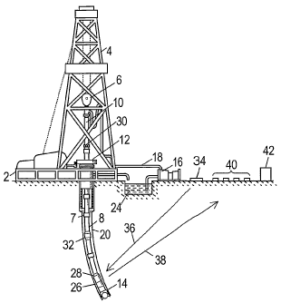
Fig. 1 shows a drilling platform 2 equipped with a derrick 4 that supports a
hoist 6.
Drilling of a well bore, for example, the borehole 20, may be carried out by a
string of drill pipes
8 connected together by "tool" joints 7 so as to form a drill string. The
hoist 6 suspends a kelly 10
that is used to lower the drill string through rotary table 12. Connected to a
lower end of the drill
2
CA 02556107 2006-08-14
WO 2005/081993 PCT/US2005/005821
string is a drill bit 14. The borehole 20 may be drilled by rotating the drill
string and/or by using a
downhole motor to rotate the drill bit 14. Drilling fluid, misleadingly
referred to as "mud", is
pumped by mud recirculation equipment 16 through supply pipe 18, through
drilling kelly 10,
and down through an interior passageway of the drill string. The mud exits the
drill string
through apertures (not shown) in the drill bit 14. The mud then travels back
up to the surface
through the borehole 20 via an annulus 30 between an exterior surface of the
drill string and the
borehole wall. At the surface, the niud flows into a mud pit 24, from which it
may be drawn by
recirculation equipment 16 to be cleaned and reused. The drilling mud may
serve to cool the drill
bit 14, to carry cuttings from the base of the borehole 20 to the surface, and
to balance the
hydrostatic pressure from the surrounding formation.
The drill bit 14 is part of a bottom-hole assembly that includes a downhole
positioning
transceiver 26. The bottom-hole assembly may further include various logging
while drilling
(LWD) tools and a telemetry transceiver 28. If included, the various LWD tools
may be used to
acquire information regarding the surrounding formations, and the telemetry
transmitter 28 may
be used to communicate telemetry information to a surface transceiver 30,
perhaps via one or
more telemetry repeaters 32 periodically spaced along the drill string. In
some embodiments,
control signals may be communicated from the surface transceiver 30 to the
telemetry transceiver
28.
Fig. 1 further shows various components of an illustrative downhole
positioning system,
in which a reference transmitter 34 transmits a pilot signal 36. The pilot
signal 36 serves as a
timing reference, and in some embodiments, it is broadcast as a low frequency
electromagnetic
signal to the downhole positioning transceiver 26 and to receivers in a
receiver array 40. In
various alternative embodiments, the pilot signal 36 may be transmitted
through the borehole by
surface transceiver 30, or omitted entirely if extremely accurate timing
references are available to
the downhole positioning transceiver 26 and the receiver array 40.
The downhole positioning transceiver 26 broadcasts a low frequency
electromagnetic
signal 38 that is coordinated with the timing reference so as to allow for
determination of travel
times between the positioning transceiver 26 and the various receivers in
array 40. The receivers
in array 40 measure the amplitude and phase of electromagnetic signal 38 and
communicate their
measurements to a data hub 42. In some embodiments, data hub 42 is simply a
collection station
for gathering and storing receiver array measurements for later analysis. In
other embodiments,
data hub 42 includes some processing capability for combining measurements
from various
receivers to determine the position and path of downhole positioning
transceiver 26. Though
3
CA 02556107 2008-05-16
shown as separate components, the reference transmitter 34 and the data hub 42
may be
integrated with one or more of the receivers in array 40.
Electromagnetic signals 36 and 38 may be transmitted and received using any of
many
suitable antenna configurations. Fig. 2 shows a magnetic field pattern
associated with an
illustrative magnetic dipole 27 that comprises many windings of an electrical
conductor. As
alternating current is passed through the electrical conductor, the magnetic
dipole 27 creates an
alternating magnetic field pattern in the shape represented by field lines 39.
(The field is axially
symmetric about axis 45.) In free space, the intensity of the magnetic field
is inversely
proportional to the distance from the transmitter, and the relative phase of
the alternating field
varies linearly with distance. Though these factors are influenced by the
subsurface earth
formations, the field amplitude and phase can still serve as a measure of
distance between the
downhole positioning transceiver 26 and a receiver in array 40.
Fig. 3 shows an illustrative layout for a surface transmitter 34 and a surface
receiver
array. As shown, surface transmitter 34 takes the form of a magnetic dipole.
In some
embodiments, the surface transmitter 34 comprises a loop with a radius of 100
meters carrying a
(pilot signal) current of 10 amperes. The pilot signal current oscillates at a
very low frequency, in
the range between 10-3 Hz and l Hz. In some embodiments, the frequency is
slowly reduced from
10-1 Hz to 10-' Hz as the downhole positioning transceiver travels farther
away from the receiver
array 40.
The downhole positioning transceiver 26 may be provided with a magnetic field
receiving
antenna. In some embodiments, this receiving antenna comprises a 5000-turn
loop of radius 6.35
cm, wrapped on a core having a relative permeability of 1000. The downhole
positioning
transceiver 26 detects the pilot signal 36 and generates a low frequency
positioning signal that is
phase-locked to the pilot signal. To transmit the positioning signal, the
downhole positioning
transceiver 26 may employ a magnetic dipole transmit antenna 27 having similar
characteristics
to the receive antenna. In some alternative embodiments, the downhole
positioning transceiver
may employ a mechanically actuated magnetic dipole transmitter.
The receivers in array 40 may each include a three-axis magnetometer. In some
embodiments, the magnetometers may be provided with accelerometers for motion
compensation.
In some alternative embodiments, each receiver may include superconducting
quantum
interference devices ("SQUIDs") for measuring magnetic field intensities. Each
receiver
4
CA 02556107 2006-08-14
WO 2005/081993 PCT/US2005/005821
measures an amplitude and phase (with respect either to a fixed point in the
array of surface
receivers, or with respect to the pilot signa136) of the received positioning
signal. The receivers
in array 40 are positioned apart to allow the measurements to be used for a
geometric
determination of the positioning of the signal source, i.e. downhole
positioning transceiver 26.
The array 40 may include a minimum of three receivers (two may be sufficient
when constraints
are placed on the borehole path), but improved positioning accuracy may be
expected as the
number of receivers is increased. The co-linearity of the receivers should be
minimized within
the constraints of feasibility.
Fig. 4 shows a block diagram of an illustrative reference transmitter. A
precision clock
402 produces an extremely stable and accurate clock signal. An oscillator 404
converts the clock
signal into a sinusoidal signal having a predetermined frequency (e.g., 0.1
Hz). A driver 406
amplifies the sinusoidal signal and powers an antenna 408 to transmit a pilot
signal 36 (Fig. 1).
Antenna 408 may be a magnetic dipole, as discussed previously, but may also
take other suitable
forms including an electric dipole or an electric monopole.
Fig. 5 shows a block diagram of an illustrative downhole positioning
transceiver. A
receive antenna 502 is coupled to a receive module 504 that detects the pilot
signal 36. A
frequency multiplier 506 shifts the frequency of the detected pilot signal to
generate a positioning
signal that is synchronized to the pilot signal. In an alternative embodiment,
a frequency divider
may be used for frequency shifting. A small multiplication or division factor
(e.g, two or three)
may be preferred to keep both signals in the low-frequency range. A transmit
module 508
amplifies the positioning signal and powers a transmit antenna 510 to transmit
the positioning
signa138 (Fig. 1). In some embodiments, the receive and transmit antennas may
be one and the
same, while in other embodiments, the two antennas may be separated and/or
orthogonally
oriented. The transmit antenna 510 may take the form of a magnetic dipole, an
electric dipole, or
a mechanically actuated magnetic source.
Fig. 6 shows a block diagram of an illustrative receiver in array 40. An
antenna 602
receives a combination of the pilot signal 36 and the positioning signal 38.
Filters 604 separate
the two signals based on their different frequencies. The pilot signal is
frequency shifted by a
frequency multiplier 606 (or a frequency divider) to reproduce the operation
of downhole
positioning transceiver 26. The positioning signal is processed by an
amplitude detector module
608 that determines the received amplitude of the positioning signals and
amplifies the
positioning signal to a predetermined amplitude (automatic gain control). A
phase-lock loop 612
generates a "clean" oscillating signal that is phase-locked to the amplified
positioning signal. A
phase detector 612 determines the phase difference between the clean
oscillating signal from
5
CA 02556107 2006-08-14
WO 2005/081993 PCT/US2005/005821
phase-lock loop 612 and the reproduced positioning signal from frequency
multiplier 606. The
phase difference and amplitude measurement are sent by an interface 614 to the
data hub 42 (Fig.
1).
Fig. 8 shows how a phase difference and amplitude measurement may be used to
calculate a signal source's distance from the receiver making those
measurements. Although the
illustrative chart applies to an alternative embodiment of the downhole
positioning system, the
principles are applicable to embodiments shown in the foregoing figures. Fig.
8 shows three
curves of phase measurement as a f-unction of amplitude for homogenous
formations with three
different resistivities: 0.1 0 m, 10 m, and 10 SZ m. Connecting these curves
are eleven cross-lines
representing different distances between the source and receiver: 100m, lkm,
2km, 3km, ...,
10km. As shown by the dotted lines, a measurement of signal amplitude (2.5x10-
6 volts) and
phase shift (45 ) for a given positioning signal frequency corresponds to a
unique combination of
resistivity (1 SZm) and distance (2km). These curves and lines can be
parameterized to allow
similar determinations for points not falling directly on the lines.
In non-homogenous formations, the resistivities of different formation
components may
be essentially "averaged" together by the propagating electromagnetic waves.
Accordingly, phase
and amplitude measurements may indicate an effective resistivity, i.e., the
resistivity for a
homogenous formation that would produce similar measurements.
Fig. 7 shows an illustrative downhole positioning method that may be employed
by the
data hub 42 or by a computer processing data collected by the hub. The method
comprises a loop
to provide tracking of the downhole positioning transceiver 26. In block 702
the current positions
of the reference transmitter 34 and each of the receivers in array 40 are
determined. In some
embodiments, these positions may be determined by global positioning system
(GPS) receivers
integrated with the corresponding components. In other embodiments, these
positions may be
determined using traditional surveying techniques. In system configurations
that allow motion of
the surface transmitter 34 and/or the receivers, these positions are
periodically re-determined.
In block 704, the current amplitude and phase measurements are collected from
each of
the receivers in array 40. In block 706, an amplitude correction is applied to
the amplitude
measurements to conlpensate for variations in receiver characteristics. In
addition, a phase
correction is applied to each of the phase measurements. The phase correction
compensates not
only for the variations in receiver characteristics, but also for the
individual propagation delays of
the pilot signal from the reference transmitter to the various receivers. In
some embodiments, an
additional adaptive phase correction may be determined to compensate for the
propagation delay
of the pilot signal from the reference transmitter to the downhole positioning
transceiver. This
6
CA 02556107 2006-08-14
WO 2005/081993 PCT/US2005/005821
additional phase correction is a function of the effective resistivity and
magnetic perrneability of
the material between the reference transmitter and the downhole positioning
transceiver, and it
changes as the downhole positioning transceiver moves relative to the
transmitter and receivers.
The additional phase correction may be applied to each of the phase
measurements or simply
included as a parameter in the position calculations.
In block 708, the transceiver's downhole position is calculated from the
amplitude and
(corrected) phase measurements. Some embodiments may perform this calculation
as shown in
the figure, but a number of algorithms may be employed for this calculation.
In some
embodiments, resistivity determinations are monitored as a function of
position and are used to
construct a model of the subsurface structure. The effects of the model are
then taken into
account for subsequent position calculations. In these and other embodiments,
array processing
techniques may be employed to estimate positioning signal wavefronts and to
calculate the signal
source position from these estimates.
In block 710, a distance and effective resistivity determination is made for
the
measurements from each receiver. This may be done as described previously with
respect to Fig.
8. In block 712, a geometrical analysis is performed on the various distance
measurements to
determine the downhole transceiver's position.
In block 714, the calculated position is used to update a current position
measurement.
(The current position measurement may be determined from a weighted average of
recent
position measurements.) The updated position measurement may in turn be used
to update a
model of the trarisceiver's path. As the transceiver 26 travels along the
borehole, the measured
positions will trace a path in three-dimensional space. The path segments
between position
measurements may be estimated by interpolation.
The loop is repeated to track the position and trajectory of the transceiver
26. Though the
transceiver's source may operate at very low (sub-hertz) frequencies, it is
desirable to employ
oversampling (or even analog processing) to enhance phase detection accuracy.
Accordingly, it is
expected that the measurement and calculation rate will be significantly
higher than the signal
frequency, e.g., a sampling rate of 1-10 Hz. Such oversampling may also allow
the foregoing
methods to be applied to wireline applications with relatively high
transceiver speeds (e.g., 1
m/s).
The methods described above can be implemented in the form of software, which
may be
communicated to a computer or other processing system on an information
storage medium such
as an optical disk, a magnetic disk, a flash memory, or other persistent
storage device.
Alternatively, such software may be communicated to the computer or processing
system via a
7
CA 02556107 2006-08-14
WO 2005/081993 PCT/US2005/005821
network or other information transport medium. The software may be provided in
various forms,
including interpretable "source code" form and executable "compiled" form.
In various alternative embodiments, the downhole positioning system may
comprise
multiple sources on the surface transmitting at different frequencies below 1
Hz. The downhole
transceiver 26 may make amplitude and/or phase measurements of the
electromagnetic signals
from the sources to allow for distance determinations to each of the sources
and a consequent
position detemiination from these distances.
Numerous variations and modifications will become apparent to those skilled in
the art
once the above disclosure is fully appreciated. For example, in some
embodiments the timing
reference (and phase differences) may be eliminated, and the distance
calculation may be based
purely on signal amplitudes measured by the receiver array. It is intended
that the following
claims be interpreted to embrace all such variations and modifications.
8