Note: Descriptions are shown in the official language in which they were submitted.
CA 02557984 2006-08-30
WO 2005/093454 PCT/US2005/006476
METHOD FOR BACKUP DUAL-FREQUENCY NAVIGATION DURING BRIEF
PERIODS WHEN MEASUREMENT DATA IS UNAVAILABLE ON ONE OF TWO
FREQUENCIES
[0001] The present invention relates generally to technologies associated with
positioning and navigation using satellites, and more particularly to dual-
frequency
navigation using the global positioning system (GPS).
BACKGROUND
[0002] The global positioning system (GPS) uses satellites in space to locate
objects
on earth. With GPS, signals from the satellites arrive at a GPS receiver and
are used to
determine the position of the GPS receiver. Currently, two types of GPS
measurements
corresponding to each correlator channel with a locked GPS satellite signal
are available for
civilian GPS receivers. The two types of GPS measurements are pseudorange, and
integrated
carrier phase for two carrier signals, Ll and L2, with frequencies of 1.5754
GHz and 1.2276
GHz, or wavelengths of 0.1903 m and 0.2442 m, respectively. The pseudorange
measurement
(or code measurement) is a basic GPS observable that all types of GPS
receivers can make. It
utilizes the C/A or P codes modulated onto the carrier signals. The
measurement records the
apparent time taken for the relevant code to travel from the satellite to the
receiver, i.e., the
time the signal arrives at the receiver according to the receiver clock minus
the time the
signal left the satellite according to the satellite cloclc.
[0003] The carrier phase measurement is obtained by integrating a
reconstructed carrier of the signal as it arrives at the receiver. Thus, the
carrier phase
measurement is also a measure of a transit time difference as determined by
the time the
signal left the satellite according to the satellite clock and the time it
arrives at the receiver
according to the receiver clock. However, because an initial number of whole
cycles in transit
between the satellite and the receiver when the receiver starts tracking the
carrier phase of
the signal is usually not known, the transit time difference may be in error
by multiple carrier
cycles, i.e., there is a whole-cycle ambiguity in the carrier phase
measurement.
[0004] With the GPS measurements available, the range or distance between a
GPS receiver and each of a multitude of satellites is calculated by
multiplying a signal's
travel time by the speed of light. These ranges are usually referred to as
pseudoranges (false
ranges) because the receiver clock generally has a significant time error,
which causes a
common bias in the measured range. In addition, several error factors exist
that can lead to
CA 02557984 2006-08-30
WO 2005/093454 PCT/US2005/006476
errors or noise in the calculated range, such as the ephemeris error,
satellite clock timing
error, atmospheric effects, receiver noise and multipath error. The common
bias from
receiver clock error is usually solved for along with the position coordinates
of the receiver as
part of the normal navigation computation.
[0005] With standalone GPS navigation, where a user with a GPS receiver
obtains code and/or carrier-phase ranges with respect to a plurality of
satellites in view,
without consulting with any reference station, the user is very limited in
ways to reduce the
errors or noises in the ranges. To eliminate or reduce some of these errors,
differential
techniques are typically used in GPS applications. Differential GPS (DGPS)
operations
typically involve one or more reference GPS receivers in fixed locations, a
user (or
navigation) GPS receiver, and communication links among the user and reference
receivers.
The reference receivers are used to generate corrections associated with some
or all of the
above error factors. The corrections are supplied to the user receiver and the
user receiver
then uses the corrections to appropriately correct its computed position.
[0006] A number of different techniques have been developed to obtain high-
accuracy differential navigation using the GPS carrier-phase measurements. The
highest
accuracy technique is generally referred to as "real-time kinematic" (RTK) and
has a typical
accuracy of about one-centimeter. However, in order to obtain that accuracy,
the whole-cycle
ambiguity in the differential carrier-phase measurements must be determined.
When the
reference receiver is a substantial distance (more than a few tens of
kilometers) from the
navigation receiver it may become impossible to determine the whole-cycle
ambiguity and
the normal RTK accuracy cannot be achieved. Under these adverse circumstances
the best
that can be done is often to estimate the whole-cycle ambiguities as a real-
valued (non-
integer) variable. This practice is often referred to as determining a
"floating ambiguity"
value.
[0007] One method for determining the "floating ambiguity" value is to form
refraction corrected code and carrier-phase measurements, scale the refraction
corrected
carrier-phase measurement to the same unit as the refraction corrected code
measurement,
and form an offset by subtracting the refraction corrected carrier-phase
measurement from the
refraction-corrected code measurement. This offset value can be recursively
averaged over
time so that it becomes an increasingly accurate estimate of the "floating
ambiguity." Exactly
2
CA 02557984 2006-08-30
WO 2005/093454 PCT/US2005/006476
the same net result can be obtained by smoothing a code measurement with a
linear
combination of the corresponding L1 and L2 carrier-phase measurements that is
formed to
match the ionospheric refraction effect of the code measurement.
[0008] Several types of differential GPS systems that provide measurements
or measurement corrections to navigation receivers are currently available.
Among them, the
High Accuracy Nationwide Differential GPS System (HA-ND GPS), which is
developed
cooperatively by several LT.S. government organizations, uses ground based
reference sites.
This system transmits the corrections to the user using Coast Guard beacons
that can reach
users at ranges of a few hundred kilometers. John Deere has developed the
StaxFireTM system,
which transmits corrections via communication satellites with both a regional
wide area
correction data stream and a global DGPS correction data stream. In these
systems,
navigation results in the 10 centimeter range can be obtained after the
carrier-phase floating
ambiguities have been determined with sufficient accuracy, that is, after
sufficient time has
elapsed since the navigation receiver starts tracking the satellite signals.
[0009] One of the principal problems of these navigation systems is that
anything such as interfering signals, shading or signal blockage, etc., which
causes one of the
signals from any of the satellites to be temporarily lost, will cause "cycle
slips" in the carrier-
phase measurements and the floating ambiguity value will no longer be correct.
In the current
commercial environment, the L2 signals are much more apt to be lost than the
L1
measurements. There are several reasons for this. First the broadcast L1
signal is stronger
than the broadcast L2 signal. In addition, commercial access to the L2 signal
requires a
"codeless" or "semi-codeless" technique to be employed to avoid the selective
availability
imposed on the L2 signal by the military. As a result, only a small amount of
interference or
signal blockage can cause a loss of the L2 measurements. Without some means of
reinitializing the floating ambiguity value, a long time interval will be
required to determine
anew the correct floating ambiguity value after the L2 signal returns.
Therefore there is a
need for a technique to reinitialize the floating ambiguity value after a
brief L2 signal outage
so that the long initialization process can be avoided.
SUMMARY
[0010] The present invention includes a method for performing backup dual-
frequency navigation whereby the L2 code and carrier-phase measurements are
synthesized
3
CA 02557984 2006-08-30
WO 2005/093454 PCT/US2005/006476
using a combination of the retained L 1 carrier-phase measurements and a model
of the
ionospheric refraction effects, which is updated when measurements on both the
L1 and L2
frequencies are available. As an optional process, a divergence between the
retained code and
carrier phase measurements can be used to detect slowly changing deviations
from the
ionospheric refraction model. This allows an increase in the interval over
which synthesized
measurements can be successfully generated.
[0011] In one embodiment of the present invention, the backup dual-frequency
navigation is performed for each satellite from which the L2 measurements are
lost for a time
period at the user GPS receiver, and the method for performing the backup dual-
frequency
navigation includes steady-state processing when measurements on both the L1
and L2
frequencies from the satellite are available. During the steady-state
processing, smoothed
code measurements and smoothed offsets between code and carrier-phase
measurements are
computed. Also, corrections to an ionospheric model are generated. Thereafter,
when direct
measurements on the L2 frequency from the satellite are unavailable, backup
operations are
performed for each measurement epoch until the L2 signals axe detected again
at the user
GPS receiver. During the backup operations, the ionospheric model corrections
are used to
generate estimated L2 carrier-phase measurements, which are used to generate
estimated
code measurements on both the L1 and the L2 frequencies. The estimated and
measured code
measurements on the L1 frequency are used in an optional step in which
ionospheric model
corrections axe updated. Upon the return of the L2 signals, a transition to
dual frequency
navigation using both the L1 and L2 signals from the satellite is performed.
[0012] Thus, the method in one embodiment of the present invention allows dual
frequency operation at a GPS receiver to continue in the situation when
signals from one or
more satellites on one of the frequencies become unavailable for a time
period.
DRAWINGS
[0013] FIG. 1 is a block diagram of a computer system that can be used to
perform
the backup dual frequency navigation method according to one embodiment of the
present
invention.
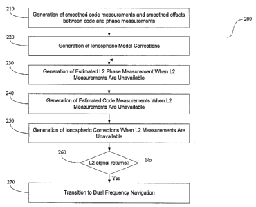
[0014] FIG. 2 is a flowchart illustrating the method for backup dual frequency
navigation according to one embodiment of the present invention.
4
CA 02557984 2006-08-30
WO 2005/093454 PCT/US2005/006476
[0015] FIG. 3 is a flowchart illustrating a step for generating smoothed code
measurements and smoothed offsets between the code and carrier-phase
measurements
during steady state processing in the method for backup dual-frequency
navigation.
[0016] FIG. 4 is a flowchart illustrating a step for generating ionospheric
model
corrections during steady state processing in the method for backup dual
frequency
navigation.
[0017] FIG. 5 is a flowchart illustrating a step for generating synthesized
(or
estimated) L2 carrier-phase measurement in the method for backup dual-
frequency
navigation when direct L2 measurements are unavailable.
[0018] FIG. 6 is a flowchart illustrating a step for generating synthesized
code
measurement in the method for backup dual-frequency navigation when L2
measurements
are unavailable.
[0019] FIG. 7 is a flowchart illustrating an optional step for updating the
ionospheric
model corrections in the method for backup dual frequency navigation when L2
measurements are unavailable.
[0020] FIG. 8 is a flowchart illustrating a transition to steady-state dual-
frequency
navigation after the L2 signal returns.
DESCRIPTION
[0021] FIG. 1 illustrates a system 100 for performing backup dual-frequency
navigation in case of an occasional loss-of lock on the L2 signal from one of
the satellites,
according to one embodiment of the present invention. As shown in FIG. l,
system 100 can
be a microprocessor-based computer system 100 coupled to a GPS receiver 110,
which
provides raw GPS observables to system 100 for processing. These observables
include GPS
code and carrier phase measurements, ephemerides, and other information
obtained according
to signals received from a plurality of satellites 101.
[0022] To facilitate differential operations, system 100 may also be coupled
to a
reference station 120 via a radio link 124. The reference station 120 provides
GPS
observables measured thereat and/or GPS corrections calculated thereat. In
wide-area or
global applications, system 100 may be coupled to one or more central hubs 130
in
CA 02557984 2006-08-30
WO 2005/093454 PCT/US2005/006476
communication with a group of reference stations (not shown) via radio and/or
satellite links
134. The hubs) 130 receives GPS observables from the group of reference
stations and
computes corrections that are communicated to the system 100.
[0023] In one embodiment of the present invention, system 100 includes a
central
processing unit (CPU) 140, a memory device 148, a plurality of input ports
153, 154, and
155, one or more output ports 156, and an optional user interface 158,
interconnected by one
or more communication buses 152. Memory 148 may include high-speed random
access
memory and may include nonvolatile mass storage, such as one or more magnetic
disk
storage devices. Memory 148 may also include mass storage that is remotely
located from
the central processing unit 140. Memory 148 preferably stores an operating
system 162, a
database 170, and GPS application programs or procedures 164, including
procedures for
backup dual frequency navigation 166 according to one embodiment of the
present invention.
The operating system 162 and application programs and procedures 164 stored in
memory
148 are for execution by the CPU 140 of the computer system 100. Memory 148
preferably
also stores data structures used during the execution of the GPS application
procedures 166,
such as GPS measurements and corrections, as well as other data structures
discussed in this
document.
[0024] The input ports 154 are for receiving data from the GPS receiver 110,
the
reference station 120, and/or the hub 130, respectively, and the output ports)
156 can be used
for outputting calculation results. Alternately, calculation results may be
shown on a display
device of the user interface 158.
[0025] The operating system 162 may be, but is not limited to, the embedded
operating system, UNIX, Solaxis, or Windows 95, 98, NT 4.0, 2000 or XP. More
generally,
operating system 162 has procedures and instructions for communicating,
processing,
accessing, storing and searching data.
[0026] As indicated by the dashed line 105 in FIG. l, in some embodiments, the
GPS
receiver 110 and part or all of the computer system 100 are integrated into a
single device,
within a single housing, such as a portable, handheld or even wearable
position tracking
device, or a vehicle-mounted or otherwise mobile positioning and/or navigation
system. In
other embodiments, the GPS receiver 110 and the computer system 100 are not
integrated
into a single device.
6
CA 02557984 2006-08-30
WO 2005/093454 PCT/US2005/006476
[0027] FIG. 2 is a flowchart illustrating a process 200 for performing backup
dual-
frequency navigation according to one embodiment of the present invention. The
process 200
is performed for each satellite 101 from which the L2 measurements are lost
for a time period
at the GPS receiver 110. As shown in FIG. 2, process 200 includes steps 210
and 220, which
are performed during steady-state processing when measurements on both the Ll
and L2
frequencies from the satellite are available. In step 210, smoothed code
measurements and
smoothed offsets between code and carrier-phase measurements are computed. In
step 220,
ionospheric model corrections are generated. Thereafter, when direct
measurement on L2
frequency from the satellite becomes unavailable, steps 230, 240, and optional
step 250 are
performed for each measurement epoch before the L2 signals returns at the GPS
receiver 110.
In step 230, the ionospheric model corrections are used to generate estimated
L2 carrier-
phase measurements, which are used in the subsequent step 240 to generate
estimated code
measurements on both Ll and L2 frequencies. The estimated and measured code
measurements on the L1 frequency are used in the subsequent optional step 250
in which
ionospheric model corrections are updated. The process 200 then proceeds to a
step 260 in
which it is determined whether L2 signals from the satellite have returned. If
L2 signals have
not returned, steps 230 through 250 are repeated for the next measurement
epoch using the
updated ionospheric model corrections. Otherwise, upon the return of L2
signals, a transition
to dual frequency navigation using both L 1 and L2 signals from the satellite
is performed in
step 270.
[0028] During steady-state processing when measurements from both Ll and L2
frequencies are available, the multipath error in each code measurement can be
minimized by
forming a combination of the Ll and L2 carrier-phase measurements that matches
the
ionospheric refraction effect in the code measurement, and by smoothing the
code
measurement with the carrier-phase measurement combination. Many receivers
make both a
C/A-code measurement and a P-code measurement on the Ll frequency. Either of
the C/A or
P-code measurement can be used as the L 1 code measurement. However, whichever
of the
two is chosen, the same should be used at the user and the reference stations)
since small
biases exist between the two measurements. In the discussion that follows, the
L1 frequency
(equal to about 1.57542 GHz) is designated as fi and the L2 frequency
(normally equal to
about 1.2276 GHz) is designated as f2. The pseudorange code measurement
(whether C/A or
P) on the Ll frequency is designated as Pl and the pseudorange code
measurement on the L2
frequency is designated as P2. The L1 carrier-phase measurement in meters will
be designated
7
CA 02557984 2006-08-30
WO 2005/093454 PCT/US2005/006476
simply as L1 and the L2 carrier-phase measurement in meters will be designated
as La. The
carrier-phase measurements are scaled by the wavelengths and an approximate
whole-cycle
ambiguity value is added to each so that the phase measurements are made close
to the same
value as the corresponding code measurement. Thus, using ~~ to designate the
raw phase
measurement in cycles at the fl frequency and ~ to designate the raw phase
measurement in
cycles at the f2 frequency, we have the following relationships:
L~ _ (~~ +N~)~ (1)
La = (~2 + Nz )~a (2)
[0029] The wavelength ~,1 for the L1 frequency is approximately equal to .1903
meters and the wavelength of 7~2 for the L2 frequency is approximately .2442
meters. The
approximate whole-cycle values of, N,° and NZ are added at the start of
carrier-phase
tracking to give values that are within one wavelength of the corresponding
code
measurements simply to keep the differences to be formed subsequently small.
[0030] FIG. 3 is a flowchart illustrating in more detail step 210 in process
200, in
which smoothed code measurements and smoothed offsets between the code
measurements
and corresponding carrier-phase measurements axe computed during steady-state
processing
when signals on both L1 and L2 frequencies are available from the satellite.
When the L2
signal is not available, the previously computed values for the smoothed P1
offset (O1),
smoothed P2 offset (~z) and the estimated O1V1~1,1 -OlVz~,z (02-01) from the
last epoch of
steady-state processing are stored and used during backup dual frequency
operation.
[0031] As shown in FIG. 3, step 210 includes a substep 310, in which a first
linear
combination M1 of Ll and L2 are formed to match the delay due to the
ionospheric refraction
effect on code measurement P1, and a substep 320, in which a second linear
combination M2
of L1 and La are formed to match the delay due to the ionospheric refraction
effect on code
measurement Pz. Substeps 310 and 320 are performed according to the following
equations:
Ml = (K, + Kz )L, - 2KZLz (3)
Mz = 2K1 Ll - (Kl + Kz )Lz (4)
8
CA 02557984 2006-08-30
WO 2005/093454 PCT/US2005/006476
where K~ and K2 are coefficients defined as follows:
2
K, = zf z - 2.5457 (5)
f - .fz
z
l~z = 2'fz z -1.5457 (6)
.f - .fz
[0032] Because the ionospheric effects on the code measurements P1 and PZ have
been matched by the respective linear combinations Ml and M2 of the carrier-
phase
measurements, and because all clock variations and motions for either the
satellite transmitter
or the user receiver have identical effects on the code and carrier-phase
measurements, Ml
and P1, or M2 and P2, should be identical except for possible whole-cycle
ambiguity errors in
the carrier-phase combination, M1 or M2, and the higher multipath noise in the
code
measurement P1 or P2, respectively. This allows the formation of smoothed code
measurements which approaches the small measurement noise of the carrier-phase
measurements but without the associated whole-cycle ambiguity.
[0033] Thus, step 210 further includes a substep 330, in which an offset
between P1
and Ml is computed, and a substep 350, in which the offset is processed in a
low pass filter to
form a smoothed offset O1 between P1 and M1 (referred in FIG. 3 and
subsequently as the
"smoothed P1 offset"). In parallel, step 210 also includes a substep 340, in
which an offset
between P2 and M2 is computed, and a substep 360, in which the offset is
processed in a low
pass filter to form a smoothed offset 02 between P2 and MZ (referred in FIG. 3
and
subsequently as the "smoothed P2 offset"). Using subscript "i" to designate
the measurements
at a specific measurement epoch, the low pass filter in substep 350 or 360
forms the
smoothed P1 or P2 offset by sequentially averaging the offset according to the
following
equation:
oa>a = oa.,~-i + (pa,~ - ~a,,a - ~a,,r-i ) ~ ~ (7)
where ~, = 1 or 2 for designating the L1 or L2 frequency, and O~,l represents
the smoothed
Plor P2 offset at the ith measurement epoch. The low pass filter in substep
350 or 370 forms
sequential averages until a maximum averaging interval is achieved and then it
converts to an
exponential smoothing filter. So, h equals to i until the maximum averaging
interval is
9
CA 02557984 2006-08-30
WO 2005/093454 PCT/US2005/006476
reached and then holds at that maximum value afterwards. It should be noted
that other forms
of low-pass filtering could be used. One alternative is to model the multipath
errors in the
code measurements as correlated noise and use a stochastic model of the
multipath error in a
Kalman filter to obtain an estimated offset between the code and carrier-phase
measurements.
[0034] Step 210 in the process 200 further includes substeps 370 and 380, in
which
the smoothed P1 and Pa are each formed by summing the corresponding offset
with the
corresponding carrier-phase measurement, as in the following:
S~ = O~ + M~ (8)
where 5~,, ~, = 1 or 2, represents the smoothed P1 or Pa code measurements.
[0035] It is noted that the values of the smoothed P1 and P2 offsets will
approach
specific values as the number of measurement epochs used in the smoothing
process (referred
herein also as the "averaging interval" or "smoothing count") increases.
Specifically, when
enough averaging has been performed, the following should hold,
O, _ (K, + Kz )OIV,~,, - 2I~zOlVz~,z
Oz = 2K101V1a,1 - (K, + K~ )~IVz~1,z (10)
where the values of ~1N1 and tlN2 represent the errors in the initial
assignment N° and NZ of
the integer ambiguities in the raw carrier-phase measurements ~1 and ~2,
respectively. For
subsequent use, step 210 further includes a substep 390 in which the
difference between the
two smoothed offsets are computed to yield an estimated tlNl~ -OIVZ~,z :
~2 ~1 - ~1 a'1 ~2 f 2 1 1
[0036] FIG. 4 is a flowchart illustrating in more detail the processing for
generating
ionospheric refraction corrections in step 220 in process 200. The ionospheric
refraction
corrections generated in step 220 are to be used to synthesize L2 measurements
when direct
L2 measurements are not available. As shown in FIG. 4, step 220 includes a
substep 410, in
which an ionospheric model is used to compute a modeled ionospheric bias term,
Im, and
optionally a modeled ionospheric rate term, Delta Im. The ionospheric rate
term is computed
CA 02557984 2006-08-30
WO 2005/093454 PCT/US2005/006476
from sequential differences of the ionospheric bias terms obtained from the
model. Any of
several ionospheric models could be used in substep 410, including the
ionospheric model in
the Wide Area Augmentation System (WAAS), whose corrections are broadcast from
the
WARS communication satellites, the real-time ionospheric model used by the
International
GPS Service (IGS), and the ionospheric model whose corrections are broadcast
from the GPS
satellites. Since most ionospheric models generate the ionospheric refraction
bias term and
rate term in the P1 code measurement at the fl frequency, the modeled bias
term and rate term
need to be divided by the K2 coefficient to obtain the expected difference
between
ionospheric delays in the P1 and P2 code measurements. Thus, step 200 further
includes a
substep 420, in which Im and Delta Im are divided by K~ for subsequent use.
[0037] Step 220 in process 200 further includes a substep 430, in which the
smoothed
code measurements computed in step 210 according to Equations (1) through (8)
are
differenced to yield a measured ionospheric bias term, and a substep 440, in
which Im/K2 is
subtracted from the measured ionospheric bias term to produce a correction,
01, to the
modeled ionospheric bias term. Substeps 430 and 440 are performed according to
the
following equation:
~ _ ~a - Si - I »t l KZ (12)
[0038] To generate an optional correction to the modeled ionospheric rate
teen, step
220 in process 200 further includes a substep 450, in which a difference
between the L2
carrier-phase measurements talcen at two consecutive measurement epochs (Delta
L2) is
subtracted from a difference between the L 1 carrier-phase measurements taken
at the two
consecutive measurement epochs (Delta L1) to yield a measured ionospheric rate
teen.
Substep 450 is followed by a substep 460, in which (Delta Im)/Ka is subtracted
from the
measured ionospheric rate term to produce a correction, O 1, to the
ionospheric rate term.
This ionospheric rate needs to be lightly filtered to provide some smoothing
without
excessive delay. Thus, step 220 in process 200 may further include a substep
470, in which
the result from substep 460 is processed in a low-pass filter to produce a
lightly filtered
ionospheric rate correction. This lightly filtered value of ionospheric rate
correction (filtering
equation not shown) is used subsequently in equation (15) below. By
differencing the
measured ionospheric values from the modeled values, it should be possible to
generate valid
estimates of the ionospheric effect for longer time intervals since a major
portion of the
11
CA 02557984 2006-08-30
WO 2005/093454 PCT/US2005/006476
ionospheric dynamics is handled by the model. In equation form, steps 450 to
460 can be
represented by:
0I = (Ll,; - Ll,;-I ) - (LZ,; - L2,;-1 ) - (I~»,r - In~,t-i ) ~ ~a (13)
where subscript i designates the current measurement epoch, and subscript i-1
designates the
measurement epoch prior to the current measurement epoch.
[0039] Steps 210 and 220 in process 200, in which values such as the smoothed
code
measurements and the corrections to the ionospheric bias term and the optional
rate term are
generated, are performed when measurements from both frequencies are
available. Given that
a sufficient interval of smoothing has occurred in the initial processing such
that the values
generated in steps 210 and 220 have most of the code multipath noise smoothed
out by
averaging, these values can be used to generate synthesized fa measurements in
steps 230
through 250 when measurements on the f2 frequency are unavailable.
[0040] FIG. 5 illustrates a process flow in step 230, in which the L2 carrier-
phase
measurement is synthesized when direct measurements on the f2 frequency are
unavailable.
As shown in FIG. 5, step 230 in process 200 includes an optional substep 510,
in which the
correction for the ionospheric bias term generated in the previous measurement
epoch and the
modeled ionospheric bias term generated in the current measurement epoch are
summed to
produce an estimated ionospheric bias term IB'°S . Ste 230 further
includes an o tional
Estimate p h
substep 520, in which the correction to the ionospheric rate term generated
while the L2
measurements were available is multiplied by the time period Ot since the L2
measurements
became unavailable and the product of the multiplication is added to the
estimated
ionospheric bias term to produce an updated estimate of the ionospheric bias
term IUpdale
Step 230 further includes a substep 530, in which the updated estimate of the
ionospheric bias
term is subtracted from a sum of the L1 carrier-phase measurement at the
present
measurement epoch and the estimated OlV,~., - OlV2~,2 to produce the
synthesized L2 carrier-
phase measurement LZ . In equation form, substeps 510, 520, and 530 can be
described
respectively by Equations (14), (15), and (16), as in the following:
I ~SQn~Qi~ = I »> ~ Kz + ~iI ( 14)
12
CA 02557984 2006-08-30
WO 2005/093454 PCT/US2005/006476
I Update - I Estimate ~ I ~t 15
Lz = Ll + (OlVz~1,z - NVa ) - IUpdate (16)
where Lz designates the synthesized L2.
[0041] FIG. 6 is a flowchart illustrating in more detail the processing in
step 240, in
which the smoothed code measurements are synthesized from the Ll carrier-phase
measurement and the synthesized L2 carrier-phase measurement. It might seem
odd that the
raw code measurement, Pl, is not used in synthesizing the smoothed code
measurement at
either frequency. Attempting to smooth the raw code measurement with the help
of the
synthesized L2 carrier-phase measurement would cause any errors in the modeled
ionospheric refraction to generate biases that would be filtered into the
offset values
represented by equations (9), (10) and (11). To avoid creating an ionospheric
refraction bias
in the offset values, a process which is parallel to that shown in Figure 1 is
used, except that
instead of an input of the code measurements and an output of the offsets, the
offsets are
input and the synthesized code measurements are output.
[0042] Accordingly, as shown in FIG. 5, step 240 includes a substep 610, in
which
the measured L1 measurement L1 and the synthesized L2 measurement Lz axe
combined to
form a carrier-phase combination MI with an ionospheric delay that matches the
ionospheric
delay in the L1 code measurement P1, and a substep 620 in which the measured
L1
measurement L1 and the synthesized L2 measurement Lz are combined to form a
carrier-
phase combination Mz with an ionospheric delay that would match the
ionospheric delay in
the undetected L2 code measurement. In equation form, substeps 610 and 620 can
be
expressed as:
M~ _ (K, + Kz )Ll - 2KzLz . (17)
Mz = 2K1L1 - (Kl + Kz )Lz (1 g)
[0043] Step 240 in process 200 further includes a substep 630, in which the
smoothed
P 1 offset O1 computed in step 210 is added to Ml , resulting in an estimated
smoothed L 1
13
CA 02557984 2006-08-30
WO 2005/093454 PCT/US2005/006476
code measurement Sl , and a substep 630 in which the smoothed P2 offset 02 is
added to Mz ,
resulting in an estimated smoothed L2 code measurement Sz , as expressed by
the following
equations:
S, - Ml + Ol (19)
Sz = Mz + Oz (20)
[0044] While the raw P1 code measurement was not used to synthesize the
smoothed
code measurements, it can be used in the optional step 250 in process 200 to
correct for small
ionospheric refraction errors, which would otherwise accumulate. FIG. 7 is a
flowchart
illustrating in more detail the processing performed in the optional step 250
in process 200.
Because the raw P1 code measurement is noisy, it must be filtered heavily in a
low-pass filter
to avoid introducing more errors from the multipath effects than it removes
from ionospheric
refraction effects. Also, because the synthesized P1 code measurement is
generated from the
L1 carrier-phase measurement, any error in the ionospheric model should affect
the
synthesized P1 code measurement in a direction opposite to the way that error
affects the raw
P1 code measurement.
[0045] Thus, step 250 includes a substep 710, in which the difference between
the
measured and synthesized code measurements is divided by 2I~2 to produce an
ionospheric
adjustment that scales with the ionospheric bias term and the optional rate
term, and a substep
720, in which this ionospheric adjustment is smoothed in a low-pass filter to
remove the
multipath errors. Step 250 further includes an optional substep 730, in which
the smoothed
ionospheric adjustment is added to the correction to the ionospheric rate term
to produce an
updated correction to the optional ionospheric rate term, and a substep 740,
in which the
smoothed ionospheric adjustment is added to the correction to the optional
ionospheric bias
term to produce an updated correction to the ionospheric bias term.
[0046] It is also possible that a two-state estimator, e.g. an alpha-beta or
I~alman
filter, could be used to generate the updated correction to the ionospheric
rate term. See Yang
et al., "L1 Baclcup Navigation for Dual Frequency GPS Receiver," Proceedings
of the l6tn
International Technical Meeting of the Satellite Division of the Institute of
Navigation
GPS/GNSS Conference, Sept. 9-12, 2003, Portland Oregon, which is incorporated
herein by
14
CA 02557984 2006-08-30
WO 2005/093454 PCT/US2005/006476
reference. By using some form of the process shown in FIG. 7, it may be
possible to extend
the time period that can be covered by the synthesis procedure in process 200.
[0047] FIG. 8 is a flowchart illustrating in more detail the processing in
step 270 in
process 200, in which a transition to dual-frequency navigation is performed
upon a
determination in step 260 that the L2 signal has returned. Two tests are
needed to determine
whether or not the "floating integer" offsets computed in step 210 can be
safely adjusted to
avoid a reinitialization of the long smoothing process otherwise required. As
shown in FIG.
8, the first test is performed in a substep 820, in which it is determined
whether or not the
interval of time ~t over which the L2 signal was lost exceeds a predetermined
threshold. If
the threshold is exceeded, then no adjustment is attempted and the smoothing
process is
reinitialized in a substep 830. Otherwise, the second test is performed in
substeps 840 and
850, in which the difference between the measured and the synthesized or
estimated L2
carrier-phase measurements is divided by the L2 wavelength to see if the
result is clo se to an
integer, i.e.:
(LZ - LZ ) / ~,2 ~ integer (21
If the result is not within some predetermined vicinity of an integer value,
substep 83 0 is
performed subsequently, in which the smoothing process is reinitialized.
Otherwise, the
result is used to adjust either the floating-ambiguity in the L2 carrier-phase
measurement or
the P2 code offset value so that the code smoothing process in step 210 can be
resumed after
this simple adjustment.
[0048] Because in practice the L1 signal is virtually never lost without a
concomitant
loss of the L2 signal, the technique described herein achieves its primary
intended purpose
when used to synthesize the L2 measurements from the L1 measurements during
loss of only
the L2 measurements. The present invention, however, can be applied to
synthesize ainy of
the L1 and L2 measurements, or measurements in some other frequency, such as
the LS
frequency (equal to about 1.1745 GHz), by using measurements from another
frequency that
is not lost, with the help of a model of the ionospheric refraction effects,
which is corrected
by measurements taken while both frequencies are available.