Note: Descriptions are shown in the official language in which they were submitted.
CA 02561205 2006-09-25
WO 2005/093453 PCT/CA2005/000444
PRIVATE LOCATION DETECTION SYSTEM
This application claims benefits from U.S. Provisional Application No.
60/555,968,
filed March 25, 2004, the contents of which are hereby incorporated by
reference.
FIELD OF THE INVENTION
The present invention relates generally to ubiquitous location tracking
system,
method, and devices that includes a system with people and obj ects wearing
tags, a network
that communicates with the tags, and a supervisory program (server) that can
track
information concerning the tags such as their location. The tag can be worn,
is capable of
communicating with a wireless network, providing real-time information about
the wearer,
and specifically providing information from which the system can derive the
tag's location.
BACKGROUND OF THE INVENTION
Private locating systems have been designed for a number of applications. Each
of
these design systems offers certain advantages depending on their related
applications.
A sample private detection systems is described in U.S. Patent No. 6,362,778
to
Neher et al. This patent describes a location system where the user retains a
portable
locator device employing various location technologies that include Global
Positioning
Satellite (GPS) System a~zd a beacon for pinpointing the device. The system
designed by
Neher has deficiencies that are:
1. The Wherify device operates on one network protocol at a time. Does not
support concurrent communication networks;
2. Can not be used to track people or assets in-doors;
3. Can not route location information between in-door and out-door facilities
or campuses;
4. The server is an ASP model; hence, integration with other critical mission
customer applications at customer site is not possible.
An example of a location detection systems is described in PCT Application No.
WO 02/054813, to Myllymal~i et at. This application describes a location
system and
components of such where a device in a wireless communication environment uses
CA 02561205 2006-09-25
WO 2005/093453 PCT/CA2005/000444
measured signal parameters, calibration data and statistical modeling to
approximate the
location of the receiver. Another location detection systems is described in
PCT
Application No. WO 03/102620, to Myllymaki et al. This application describes a
component of a location system where a device's location is estimated based on
a
probabilistic model and a set of measured signal parameters in a wireless
conununication
environment. Yet another location detection system is described in PCT
Application No.
WO 03/102621, to Myllynaki et al. This application describes a component of a
location
system where a device's location is estimated based on a location estimation
module using a
probabilistic model and sequence of observations in a wireless communication
enviromnent.
Furthermore, PCT Application No. WO 031102622, to Myllymaki et al. describes a
component of a location system where a device's location is estimated based on
a location
estimation module using a probabilistic model and construction of the model
based on
probability distributions of signal parameters in a wireless communication
environment.
Further, PCT Application No. WO 2004/008795 to Misikangas et al. describes a
component
of a location system where a graph representing permissible locations and
transitions is used
to estimate a device's location based on sequence of measured signal
parameters, calibration
data and statistical modeling to approximate the location of the receiver.
These systems
designed by Myllymaki and Misikangas have the following deficiencies:
1. The systems do not provide for simple calibration for premise modeling.
2. The systems do not provide for ground-truth location information. It does
not eliminate uncertainties due to RF propagation.
3: The systems have no scheme for real-time calibration. It relies on
statistical
best estimate on input.
4. The systems are server software solution only.
In order to meet current demands placed on locating applications, there is a
need to
further enhance the tracking and locating capabilities of these systems.
SUMMARY OF THE INVENTION
The invention is advantageous in that it provides a private ubiquitous end-to-
end
locating detection system.
There is another advantage in that the invention provides seamless in-door and
out-
doors coverage.
2
CA 02561205 2006-09-25
WO 2005/093453 PCT/CA2005/000444
There is another advantage in that the invention does not depend on the use of
GPS but
can incorporate it as required.
A further advantage of the present invention is to provide the Ubiquitous
Location
Tracking (ULT) system with concurrent commercial network communication paths;
provides flexibility in geographic coverage. Cost incursion for end-user
public networks are
utilized only when necessary.
Still a further advantage is the API which incorporates new conunercial
networlcs or
proprietary networks such as RF(Radio Frequency), 1XRTT, GPRS, WiFi, IrDA
(Infrared
Data) and UWB for an end-user plug-and-play deployment.
It is yet a fuxther advantage of the present invention wherein the user wears
a
"wearable" tag for detection of motion and location wirelessly.
Still a further advantage of the present invention is that it is possible to
send messages to
the "wearable" tag via bi-directional communication or messaging that stores
data to device
or server dynamically.
Still a further advantage of the present invention is that the Ubiquitous
Location
Tracking (ULT) tag uses tapping to signal for help and can also trigger more
extreme
emergency alarm if the wearer falls.
Yet a further advantage of the present invention is that it can update
location and other
real-time information of people and objects wearing the tags to other
applications without
affecting the acquisition of this data.
In accordance with a first aspect of the invention, there is provided a method
of
assessing the location of a moveable device, comprising receiving from each of
a plurality
of base stations, a radio frequency signal used by the moveable device to
assess a signal
strength of the radio frequency signal from the one of the plurality of base
stations
originating the radio frequency signal; receiving a proximity signal
indicating that the
moveable device is in the vicinity of a proximity sensor at a known location;
transmitting
indicators of signal strengths of the radio frequency signals, and
transmitting proximity
data indicative of the proximity signal to a computing device for computing at
the
computing device an estimate of the location of the moveable device based on
the indicators
of signal strength and the proximity data.
In accordance with a second aspect of the present invention, there is provided
at a
computing device, a method of estimating the location of a moveable device,
comprising
3
CA 02561205 2006-09-25
WO 2005/093453 PCT/CA2005/000444
storing groups of signal strengths for each of a plurality of geographic
zones, each group
representative of expected signal strengths of radio frequency signals from
multiple base
stations as received by the moveable device when in the zone; receiving from
the moveable
device, a plurality of signal strength indicators, each of the signal strength
indicators
indicative of a strength of a radio frequency signal originated by one of a
plurality of base
stations; comparing groups of the plurality of received signal strength
indicators to the
groups of stored signal strength indicators, to assess which of the plurality
of geographic
zones the moveable device is in.
In accordance with a third aspect of the present invention, there is provided
a computing
I O device comprising a processor in communisation with computer readable
memory, the
computer readable memory storing groups of signal strengths for each of a
plurality of
geographic zones, each group representative of expected signal strengths of
radio frequency
signals from multiple base stations as received by a moveable device when in
the zone; the
computer readable memory further storing processor executable instructions
adapting the
computing device to receive from the moveable device, a plurality of signal
strength
indicators, each of the signal strength indicators indicative of a strength of
a radio frequency
signal originated by one of a plurality of base stations; and compare groups
of the plurality
of received signal strengths to the groups of stored signal strength
indicators, to assess
which of the plurality of geographic zones the moveable device is in.
In accordance with a fourth aspect of the present invention, there is provided
at a
computing device, a method of estimating the location of a moveable device,
comprising
receiving from the moveable device, a plurality of signal strength indicators,
each of the
signal strength indicators indicative of a strength of a radio frequency
signal originated by
one of a plurality of base stations; receiving proximity data indicative of
having sensed the
moveable device in the vicinity of a proximity sensor at a lCllown location;
computing an
estimate of the location of the moveable device based on the indicators of
signal strength
and the proximity data.
In accordance with a fifth aspect of the present invention, there is provided
a moveable
device, comprising a plurality of radio receivers, each radio receive for
receiving a specific
type of radio frequency signal from a plurality of base stations; a processor
operable to
provide signals indicative of signal strengths of radio frequency signals from
a plurality of
4
CA 02561205 2006-09-25
WO 2005/093453 PCT/CA2005/000444
base stations originating radio frequency signals received by a selected
active one of the
plurality of radio receivers; the processor operable to activate different
ones of the plurality
of radio receivers as the mobile device moves; at least one radio transmitter,
operable to
transmit the signals indicative of signal strengths of radio frequency
signals.
BRIEF DESCRIPTION OF THE DRAWINGS
These and other features of the invention will become more apparent in the
following detailed description wherein reference is made to the accompanying
drawings, in
which like reference characters designate the same or similar parts
throughout.
FIG. 1 is an illustration of a private ubiquitous location system in
accordance with
an embodiment of the present invention;
FIG. 2 is a flow diagram illustrating the flow between different operating
modes of
the private ubiquitous location system;
FIG. 3A and 3B are block diagrams of the internal components of the
wearable/aimer devices in accordance with an embodiment of the present
invention; and
CA 02561205 2006-09-25
WO 2005/093453 PCT/CA2005/000444
FIG.4A, 4B, 5 and 6 are flow charts of software for controlling the devices
illustrated in FIG 1
DESCRIPTION OF THE PREFERRED EMBODIMENT
s In order to meet current demands placed on locating applications, there is a
need
to further enhance the tracking and locating. capabilities of systems
incorporated in the
prior art. This is achieved by the present embodiment of the invention through
real-time
data collection of people and objects wearing tags, as well as ensuring that
the device
being tracked does not broadcast its position, hence providing greater
security. The
i o ubiquitous private detection system of the present embodiment supports
concurrent
communication networks, ability to track people and assets in-doors and out-
doors, route
information between in-door and out-door facilities, integrate with customer
applications,
enable simple calibration for premise modeling, include ground truth
information;
incorporate real-time calibration, minimize computations, and be a full system
solution
~ s comprising devices, methods, network integration, and application
integration.
It is possible to replace these systems with a wearable/aimer/network system
offering various advantages that may include:
1. Ubiquitous devices can switch to 'different networks as user moves between
in-
door or out-door locations;
20 2. Uses simple data model for deriving location. Does not need extensive
calibration data and;
3. Provides accurate positional information.
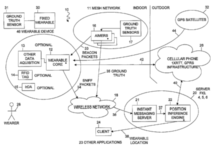
FIG. 1 illustrates a private Ubiquitous Location Tracking (ULT) system, 10, of
the present invention incorporating the Position Inference Engine (PIE), 22,
and mesh
2s networks, 11. The detection system, 10, comprises the following: a wearable
device, 46 ,
an aimer device, 16, server, 20 , wireless network, 18, cellular phone
infrastructure, 26,
GPS satellites, 32, and client, 24, which can operate in-door and out-door.
Later sections
will reference FIG. 2, 3A, 3B, 4, 5, and 6, to describe the aimers, 16,
wearable, 46, and
Position Inference Engine, 22.
3o For in-door operation, the mesh network, 11, consisting of aimers, 16,
broadcast
low-power beacon packets, 33, which are received by wearable, 46, which are a
6
CA 02561205 2006-09-25
WO 2005/093453 PCT/CA2005/000444
component of tags worn by people, 28, or items being tracked. The mesh
network, 11,
consists of aimers, 16, located within close proximity to one another such as
within 10
metres. The wearable device also referred to as "tags", 46, includes the
wearable module,
12, and optionally includes other data acquisition systems (such as for
acceleration, pulse
rate, etc.), 13, RFID (Radio Frequency Identification) tag, 14, and IrDA
(Infrared Data)
interface, 1 S. Each wearable, 46, receives the beacon packets, and extracts
signal
parameters from these packets. It collects data from the other data
acquisition systems,
13, and the RFID tag, 14, and transmits them in sniff packets, 34, to a server
20 via a
wireless network, 18. During operation, wearers, 28, may wander within
physical
to proximity of an aimer, 16. Some aimers have ground truth sensors, 17, for
detecting
proximity of objects, such as wearers, 28. The implementation of proximity
sensors can
be implemented using known technology such as proximity switches based on
Infrared,
photocell, ultrasonic, magnetic, RFID tagging, and others. The purpose for
ground truth
sensing is'to improve the accuracy of location information of the wearable,
46. Upon
t s detection of a wearable within proximity, the aimer, 16, identifies the
wearable, 46,
within vicinity based on data in its sniff packets, 34, or other data such as
the wearable
RFID tag, 14, or other identifying markings that may be incorporated. The
aimer, 16,
transmits ground truth packets, 35, to the wireless network, 18. The wireless
network,
18, is typically part of a facilities infrastructure and can support other
wireless network
2o data trafFc and applications, for communication through a link, 36, which
may be
wireless or wired, such as Ethernet, to a server, 20. The server, 20,
generally supports
other applications, but in order to support the ubiquitous location system, it
uses an
instant messaging server (IMS), 21, to collect the data from the sniff
packets, f4, and
ground truth packets, 35. The IMS is known software technology already used in
other
25 distributed software applications. The Position Inference Engine (PIE), 22,
uses the data
from sniff packets, 34, and ground truth packets, 3S, to determine the
location of the
wearable, 46, within the in-door facility. PIE, 22, provides a software
interface to define
wearable location, 38, for other applications, 23, and a client program, 24,
in particular,
to use the wearable location data and other real-time data if any. The client
program
3o graphically displays the locations of wearables, 46, and may reside on a
device such as a
notebook computer, PDA, cell phone, tablet PC, desktop PC, or other systems.
7
CA 02561205 2006-09-25
WO 2005/093453 PCT/CA2005/000444
For out-door operation, the wearable, 46, will be out of range for receiving
beacon
packets, 33, from the aimers, 16, in the mesh network, 11. The invention
provides for
two optional techniques for tracking location although with lower accuracy.
The first
technique uses the cellular phone infrastructure, 26. The cellular
infrastructure, 26, uses
, existing technology for as location determination for mobile phones placing
emergency
911 calls. The second technique uses GPS satellites, 32. In this case, the
wearable, 46,
receives GPS satellite data, 44, and assess its geographic coordinates. For
both of the
techniques, the wearable, 46, acts like a mobile phone to connect to the
cellular
infrastructure, 26, through a cellular phone call link, 42. The cellular phone
I o infrastructure, 26, dispatches location information to the server, 20
through a link, 40,
which may be implemented using known technology such as a wide-area network
(WAN) connection. For the first technique, the cellular phone infrastructure
determines
the location of the calling wearable, 46, and in the second technique, it
passes along the
GPS data. The server, 20, makes this information accessible to PIE, 22, which
then
I s provides this data through a software interface, 38, to other
applications, 23, or to the
client program, 24, which graphically displays the location of the wearable,
46. The client
program, 24, works on .NET, Pocket PC, Windows, RIM, PALM operating on various
machines such as cell phones, PDA's, tablets, laptops or desktops where the
client
communicates with the server 20, has instant messaging to other components,
22, 23 and.
20 12.
FIG. 2 illustrates the flow between different operating modes for the key
components identified in FIG. l as the aimers, 16, wearable, 46 and Position
Inference
Engine, 22. The Wearable device spends a portion of time in a sleep mode in
order to
conserve battery power. It periodically wakes up, and enters a sniff mode. In
this mode,
25 it checks for beacon packets,33, sent by aimers,l6. Upon reading beacon
packets, 33, in
an in-door scenario, it enters the in-door mode. Alternatively, when no beacon
packets,
33, are detected, it enters an out-door mode. In the in-door mode, the
wearable device
stores the beacon packet data,..which in particular includes signal strength
received from
the aimer and transmits this beacon packet information to the in-door wireless
network.
3o The out-door mode uses the cellular phone infrastructure, optionally with
GPS, as
8
CA 02561205 2006-09-25
WO 2005/093453 PCT/CA2005/000444
described earlier concerning FIG. 1. In both cases, the wearable returns to
the sleep
mode to repeat the sequence.
The aimer device,16, operates repetitively in two modes. In the timer
synchronization mode, all aimers,l6, receive a synchronization packet
originating from
the server using the wireless network. Each aimer, 16, will use a specified
time offset to
schedule when it broadcasts beacon packets. The offsets are assigned in a way
so that
aimers, 16, only use the same time offset if they are out of range of each
other. This
enables aimers, 16, to share the same radio frequency channel with minimal
risk of
beacon packets, 33, colliding when they are transmitted at the same time.
After timer
t o synchronization, the aimers broadcast beaoon packets, 33, at the same
periodic interval as
specified by their assigned time offsets. Message packets for wearables 46, if
any, are
sent immediately following a beacon packet, 33. Qver time, the aimer,16,
clocks will
drift out of synchronization. Hence, after a specified time period, the
aimers, l6, will re-
enter the time synchronization mode to repeat the sequence. .
I S The Position Inference Engine (PiE), 22, uses four primary subtasks of
processing. Standard multiprocessing data synchronization techniques commonly
used in
software systems ensures that data is correctly passed. from one subtask to
the next. In
the sniff update subtask, PIE , 22,acquires and updates a table of data,
including aimer
received signal strength values from sniff data sent by the wearables, 46.
20 The next subtask is locate wearabies, 46, within zones. A zone is a group
of
aimers, 16, within range of each other. Generally, zones are defined so that
any aimer,
1.6, may be assigned to several zones. Each zone has a data table, also known
as a zone
map, that defines expected Aimer, 16, signal values for a set of physical
locations within
that zone. Using signal strength data from the previous subtask, PIE, 22,
determines the
25 table entry with the closest match. Hence this table lookup procedure
provides the
physical location of the wearable, 46, within that zone. PIE, 22, converts the
local zone
position for each wearable, 46, and zone combination to a global coordinate
based on a
common reference point within a facility. Because aimers,l6, broadcast at low
power,
mufti-path effects of radio propagation are minimized, and there is a stronger
correlation
30 of signal strength to linear distance from aimers,16. Furthermore, because
aimers, 16, are
located closer to one another, there are fewer walls and other objects between
a wearable
9
CA 02561205 2006-09-25
WO 2005/093453 PCT/CA2005/000444
and an aimer to cause radio attenuation propagation effects. Hence there is a
stronger
correlation between the signal strengths of aimers, 16, for points located
within that zone.
The next subtask is wearable global locations. A wearable, 46, is generally
within
several zones. In the previous subtask, PIE, 22,has determined the wearable,
46 location
locally within that zone. To improve location accuracy, PIE, 22, averages the
global
locations derived from the different zones for each wearable. This produces
one global
coordinate based location for each wearable,46.
The last subtask is display and management. In this subtask, PIE, 22, provides
the
most current set of wearable data, including location in particular. Other
applications
1 o such as graphical client displays can use this data. This subtask also
archives previous
snapshot data to use for historical movement information and tracking.
A block diagram illustrating the internal components of the wearable device,
46,
is shown in FIG 3A. Positioned within the wearable core, 12, and controlling
the
operation thereof is a processor, 70. The processor 70 includes a real-time
clock to
~ 5 control the timing for switching modes. Connected to the processor 70 and
providing
power to the wearable unit device 46 is an internal power source 72. The
battery sensor
78 senses the power of the power source and provides a battery power signal to
the
processor 70 to safely shutdown the. wearable device 46 if required. The
shutdown
feature may include a special shutdown message sent to the Position Inference
Engine 22,
2o so that this event may be acted upon as required. A memory 76 is provided
for storing
data processed by the processor. A wireless RF interface 74 is provided for
receiving
beacon packets 33 and transmitting sniff packets 34. A diversity switch 80 is
provided
for receiving beacon packets 33 from alternative antennas for improved
location
estimation by PIE 22. A GPS receiver option 82 is provided for receiving GPS
satellite
25 signals 44. A cell phone interface option 84 is provided for connecting
with the cellular
phone infrastructure 26. A data acquisition interface 86 is provided for
acquiring other
data from a wearer 28, such as an accelerometer 88 which can be provided for a
feature to
assess whether the wearer 28 has fallen. An IrDA (Infrared data interface)
option 90 is
provided for e~cchanging data to and from the wearable device 46 using a
device such as a
3o PDA used by a physician. An RFID tag option 92 is provided for RFID
tracking systems.
CA 02561205 2006-09-25
WO 2005/093453 PCT/CA2005/000444
A USB (Universal Serial Bus) is provided for connecting a computing device for
maintenance purposes.
A block diagram illustrating the internal components of the aimer device 16
and
ground truth sensor 17 is shown in FIG 3B. Positioned with the aimer device,
16, and
s controlling the operation thereof is a processor, 50. The processor includes
a real-time
clock to control the timing for switching modes, timer synchronization, and
beacon
packet 33 transmission as illustrated in FIG. 2. Connected to the processor 50
and
providing power to the aimer 16 and ground truth sensor 17 is an external
power source.
Normally the power source uses power from a wired data communication line such
as
1 o power over Ethernet, although standard wall outlet power can also be used.
A memory
53 is providing for storing data processed by the processor such as data
received for
transfer to other devices. A wireless RF interface 54 is provided for
transmitting beacon
packets 33 and messages to wearables 46. A proximity detector option 58 is
provided fox
implementing the ground truth sensor 17. An RFID reader option 60 is provided
for
15 RFID tracking systems and alternative ground truth sensor implementation.
A flowchart illustrating control of the wearable devices for in-door use is
illustrated in FIG. 4A. Step 100 is putting the wearable device, 46, in a
sleep mode as
shown in FIG. 2. Step 101 is the process of sniffing beacon packets 33 and
storing
beacon data in memory 76. For in-door operation, beacon packets 33 were
detected. Step.
20 102 is a decision block to assess whether additional messages. have been
sent by aimers
16. Program execution proceeds to step 103 if yes. Otherwise it proceeds
directly to step
104. Step 103 is the process of handling of messages as required. For example,
a
software management. system may send a reminder message to a wearer 28 with a
wearable device 46 to take specified medication. Step 104 is a decision blflck
to assess
25 whether the wearable device 46 has other data to send, such as from other
data
acquisition 13, RFID tag 14, or IrDA 15. Program execution proceeds to step
105 if yes.
Otherwise it proceeds directly to step 106. Step 105 is the process to acquire
the other
data and to store it in memory 76. Step 106 is the process to retrieve the
data stored in
memory 76 and transmit sniff packets 34 using the wireless RF interface 74.
Upon
3o completion of this data transmission, the wearable proceeds to step 100 to
resume a sleep
state for power saving.
11
CA 02561205 2006-09-25
WO 2005/093453 PCT/CA2005/000444
A flowchart illustrating for control of the wearable devices for out-door use
is
illustrated in FIG. 4B. Step 107 is a decision block to assess whether beacon
packets 33
were received. Program execution proceeds to step 102 if yes, being the in-
door scenario
illustrated in FIG 4A. Program execution proceeds to step 108 if no beacon
packets 33
were detected. The wearable device 46 assumes that it is no longer in-doors
within range
of the mesh network of aimers 11. Therefore it attempts to use other means of
communication if available. Step 108 is a decision block to assess whether the
wearable
device 46 includes a GPS receiver 82. Program execution proceeds to step 109
if yes.
Otherwise it proceeds to step.l l l . Step 109 is the process to read GPS data
44 from GPS
satellites 32, and then proceeds to step 110. Step 110 is the process to
calculate the GPS
coordinates of the wearable device 46 and to send GPS coordinates to the
server 22 using
a cellular phone connection 42 to the cellular phone infrastructure 26. After
the GPS
coordinate data has been sent, program execution proceeds to step 100 to
return to a sleep
mode. Step 111 is a decision block to assess whether the wearable device 46
includes a
l 5 cell phone interface 84. Program execution proceeds to step 112 if yes.
Otherwise it
proceeds to step 113. Step 112 is the process to call the cellular phone
infrastructure 26
using cell phone interface 84 to instruct it to assess the location of the
wearable device
46. After the call has been handled, program execution proceeds to step 100 to
return to
sleep mode. Step 113 is the process to indicate that location update data is
unavailable.
2o In the event that a wireless network connection is possible to the server
20, the sending of
this data will inform PIE 22 that no update data was available. PIE 22 can use
this
information to inform other applications concerning the situation. After step
113 is
completed, program execution proceeds to step 102 as shown in FIG 4A.
A flowchart illustrating control of the Aimer device is illustrated in FIG 5.
Step
25 200 is the process to control timer synchronization mode described
previously when
describing the aimer device 16 in FIG. 2. The result of this process is that
the aimer
device 16 will have specified time interval scheduling to broadcast beacon
packets 33.
Program execution proceeds to step 201 to enter a program loop for sending a
set number
of beacon packets 33 until timer synchronization of step 200 is to be
repeated. Step 201
3o is the process to transmit the beacon packet 33 at the specified time
interval using the
wireless RF interface 54. Note that processor 50 uses an internal clock to
determine the
12
CA 02561205 2006-09-25
WO 2005/093453 PCT/CA2005/000444
time interval. The process waits at step 201 until the internal clock has
timed out to the
specified interval. Program execution proceeds to step 202, which is to
increase the
beacon packet count. Program execution proceeds to step 203. Step 203 is a
decision
block to assess whether there are messages to send to wearable device 46.
Program
execution proceeds to step 204 if yes. Otherwise it proceeds to step 205. Step
204 is the
process to broadcast messages that are stored in memory 53 using the wireless
RF
interface 54. Step 205 is a delay process. The purpose of the delay is to
enable the aimer
device 16 to handle ground truth data if any. Program execution proceeds to
step 206.
Step 206 is a decision block to assess whether a wearable has been detected by
a
proximity detector 58 or by RFID reader 60. Program execution proceeds to step
207 if
yes. Otherwise it proceeds to step 208. Step 207 is the process to acquire the
ground
truth data. For example, it may record the time when proximity detector 58 has
been
triggered. PIE 22 can use the time information to see which wearable device 46
recorded
very high beacon packet 33 signal strength for that aimer 16. This would imply
the
wearable device 46 was the one detected by the proximity detector 58. If the
RFID
reader 60 was used, the data from the wearable RFID tag 14 is sent by the
aimer 16.
Program execution proceeds to step 208. Step 208 is a decision block to assess
whether a
predetermined number of beacon packets 33 have been sent by using the count
variable
that was incremented in step 202. Program execution proceeds to step 209 if
yes.
° Otherwise it proceeds to step 201 to repeat the program loop for
sending beacon packets
33. In the case when the set number of beacon packets 33 have been sent, step
209 resets
the beacon packet count. Program execution proceeds from step 209 to step 200
to
. control the timer synchronization mode.
A flowchart illustrating control of the Position Inference Engine is
illustrated in
FIG 6. Update sniff table 400 is the process to update the subtask as
described for FIG 2.
Time synchronization 200 is the startup and initialization process for the
subtask locate
wearables within zones for FIG 2. The program loop begins at step 301 which is
the
process to point to the first zone. In step 302, PIE 22 retrieves the zone
map. In step 303,
PIE 22 determines which wearables 46 are in the current zone being examined.
It builds
3o a list of the wearables 46 within that zone. Step 304 is a decision block
for assessing
whether there are wearables 46 remaining to be processed from the list of
wearables 46.
13
CA 02561205 2006-09-25
WO 2005/093453 PCT/CA2005/000444
Program execution proceeds to step 305 if there are any to be check. Otherwise
it
proceeds to step 307 for handling the next zone. Step 305 are the processes
involved in
determining the table entry with the closest match as described for FIG 2. PIE
22
retrieves the beacon signal strength data from the wearable device 46. It
seaxches for the
table entry with the closest match. It also retrieves ground truth data if
any. PIE 22 then
retrieves the position coordinate information stored in the table entry to use
as the local
location coordinate for the wearable device 46. It. then transforms the local
coordinates to
global coordinates and stores the wearable global coordinate and the zone.
Program
execution proceeds to step 306 to retrieve the identifier for the next
wearable device 46 in
t o that zone. Program execution then proceeds to step 304 to repeat the loop.
If there are no
remaining wearables 46 to check in the current zone, the loop exits and
program
execution proceeds to step 307. Step 307 is a decision block to assess whether
there are
more zones to check. If yes, program execution proceeds to step 308 to point
to the next
zone and to resume the processes in steps 302, 303 and so on to determine the
positions
t 5 of the wearable device 46 in that zone. Otherwise, program execution
proceeds to step
301 to repeat the whole cycle beginning with the first zone.
Step 500 is the startup and initialization process for the subtask wearable
global
locations for FIG 2. In step 501, PIE begins a loop for averaging the global
locations
derived from the different zones for each wearable. Alternately, if the
wearable is
20 outdoors, multiple outdoor readings may be obtained for calculating its
position more
accurately. This produces one global coordinate based location for each
wearable device
46. Step 501 is the process to point to the first wearable 12. step 502 is to
retrieve the .
global coordinates recorded for that wearable 12 from all the zones the
wearable was
located within. Step 503 is the calculation to produce the average. Step 504
is to record
25 a single location coordinate for that wearable 12. Step 50~ is a decision
block to assess
whether there are more wearable devices 46 to process. If yes, program
execution
proceeds to step 506 to point to the next wearable. Otherwise program
execution
proceeds to step SO1 to repeat the cycle beginning with the first wearable.
Task
synchronization.is necessary.to ensure that repeating the cycle occurs with
new wearable
3o data updates from the previous PIE 22 subtasks.
Z4
CA 02561205 2006-09-25
WO 2005/093453 PCT/CA2005/000444
Steps 600 and 601 are processes for the subtask display and management for
FIG.
2. Step 600 is the process to retrieve the wearable locations recorded by step
504.
Process synchronization techniques can ensure that data for any wearable
device 46 is not
being accessed while step 504 is updating location data for that specific
wearable 12.
Step 601 involves any processes that use the location and other information
from the
wearable devices 46. Furthermore, step 600 stores the data in a table for
access by step
601. This acts like a double buffer. Other applications in step 601 can access
~a stable
image of wearable,condition without consideration to other wearable data
updates that are
underway in other parts of PIE 22.
1 o While certain novel features of this invention have been shown and
described, it is
not intended to be limited to the details above, since it will be understood
that various
omissions, modifications, substitutions and changes in the forms and details
illustrated
and in its operation can be made by those skilled in the art without departing
in any way
from the spirit of the present invention.
1 s It should be noted that although the description refers specifically to
indoor and
outdoor locator mechanisms, the indoor locator mechanism may extend to an
outside area
depending on the implementation, as will be appreciated by a person skilled in
the art.
For example, if an institution comprises a courtyard that is physically
located outside,
aimers may be set up for the courtyard. Ultimately, it is a business rule
decision for the
2o administration of the institution; which the technology is capable of
performing_