Note: Descriptions are shown in the official language in which they were submitted.
CA 02562924 2006-10-17
WO 2005/114253 PCT/GB2005/001943
Laser Radar Device and Method.
The present invention relates to coherent laser radar (lidar) devices and a
method for
operating such devices.
Lidars are well known and have been used to measure wind profiles for many
years. The
basic principle of a lidar device is to direct a laser beam to a point or
region in space and
to detect the returned signal. Measurement of the Doppler shifted light back-
scattered by
small natural particles and droplets (aerosols) present in the atmosphere is
used to
provide a measure of the line of sight wind speed. If the laser beam is
scanned, multiple
wind velocity components can be determined allowing more information on the
wind
vector to be calculated.
An example of an early, carbon dioxide laser based, lidar is described in
Vaughan, J M et
al: "Laser Doppler velocimetry applied to the measurement of local and global
wind",
Wind engineering, Vol. 13, no. 1, 1989. More recently, optical fibre based
lidar systems
have also been developed; for example, see Karlsson et al, Applied Optics,
Vol. 39, No.
21, 20 July 2000 and Harris et al, Applied Optics, Vol. 40, pp 1501-1506
(2001).
Optical fibre based systems offer numerous advantages over traditional gas
laser based
systems. For example, optical fibre based systems are relatively compact and
can be
fabricated using standard telecommunication components which are moderately
priced
and typically very reliable.
Following the recent increase in the exploitation of wind power, there is now
a
requirement for anemometers that are capable of making reliable wind speed
measurements over prolonged periods of time. These routine wind speed
measurements
may be used to assess the suitability of proposed wind turbine sites, to
measure the
power extraction efficiency of existing wind turbines or even to form part of
a wind
turbine control system. Traditionally, mechanical "cup" anemometers have been
used to
make such measurements but this often requires the construction of masts or
towers to
enable the device to be mounted at the height above the ground at which wind
speed
measurements are required. This can prove quite costly, especially where the
assessment
of numerous potential sites is required.
1
CA 02562924 2013-06-07
31158-26
Although optical fibre based lidars have the potential to replace the
traditional cup
anemometer, this will only occur if and when it can be ensured that the data
acquired
over prolonged periods of time is at least as reliable as that produced by
known
mechanical systems. To date, concerns over the long term reliability of wind
speed data
acquired using lidar based anemometers has hindered their uptake as
replacements for
traditional mechanical cup anemometer based systems.
Some embodiments of the present invention may provide a lidar device for
atmospheric
wind speed measurements, and a method of operating such a device, that
provides
reliable measurements over prolonged periods of time. It is a further object
of the
invention to provide an improved method of analysing data acquired by a lidar
device.
According to a first aspect of the present invention, a coherent laser radar
device for
atmospheric wind speed measurement comprises a transmitter for focussing a
beam of
light to a remote probe volume, a receiver for detecting back-scattered light,
and an
analyser for calculating wind speed at the remote probe volume from the
Doppler shift in
frequency of the detected back-scattered light, characterised in that the
analyser is ,
arranged to monitor for the presence of, and/or to ensure the calculated wind
speed is
corrected for, any Doppler frequency components of the detected back-scattered
light
that arise from back-scatter off cloud located at a range greater than the
range of the
remote probe volume.
As outlined above, prior art coherent laser radar devices are inherently
reliable in the
sense that they comprise optical transmitters that will accurately and
reliably transmit a
beam of light in a known direction and receivers that can consistently detect
back-
scattered light from a known direction with a substantially invariant
sensitivity. In ideal =
conditions, prior art Coherent laser radar devices are thus capable of
acquiring highly
accurate wind speed information for a remote probe volume of interest.
However, it has
been found that under certain atmospheric conditions significant errors are
associated
with the wind velocity values' calculated by such prior art coherent laser
radar device. In
particular, it has been found that in the presence of a low cloud base the
detected back-
scattered signal can be dominated, or at least comprise a significant
component, that does
2
CA 02562924 2006-10-17
WO 2005/114253 PCT/GB2005/001943
not actually arise from reflections off aerosols in the probe volume of
interest but is due
to reflections from the higher density of aerosols (water droplets) found in
cloud. In such
a situation, prior art coherent laser radar devices .provide a "false" wind
speed reading
that is not truly indicative of the wind velocity in the remote probe volume
because of
the effect of the cloud returns.
The present invention thus provides a lidar device in which an analyser is
provided that
is arranged to monitor for the presence of, and/or to ensure the calculated
wind speed is
corrected for, any Doppler frequency components of detected back-scattered
light that
arise from back-scatter off cloud located at a range greater than the range of
the remote
probe volume (i.e. for light reflected from aerosols Outside of the remote
probe volume).
A device of the present invention thus has a reduced susceptibility to false
readings due
to cloud, or at least provides an indication that the calculated wind velocity
values have
been affected by a cloud return signal and are likely to have a certain level
of uncertainty
associated therewith.
A device of the present invention thus ensures the operator has greater
confidence in the
wind velocity values calculated by the lidar. For example, the indication may
be in the
form of an error output associated with each calculated velocity value or it
may be that
only velocity values having a certain confidence level associated therewith
are output or
recorded by the lidar. In other words, the device comprises means for
providing an
indication of the confidence associated with calculated wind velocities. The
present
invention'thus provides .a lidar device that, unlike prior art systems, is
capable of making
reliable long term, unattended, wind velocity measurements even in the
presence of an
intermittent and/or varying cloud base.
=
It should be noted that the back-scattered light detected by the receiver
provides a
measure of the "line of sight" wind velocity; i.e. the returned light is
Doppler shifted by
an amount related to the velocity components of aerosols parallel to the
transmit/receive
beam direction. However, different wind velocity components can advantageously
be
determined by providing scanning means to scan the beam of light transmitted
by the
transmitter and the receive beam defined by the receiver within the remote
probe
volume. Scanning the lidar in this manner enables the wind vector within the
remote
3
CA 02562924 2006-10-17
WO 2005/114253 PCT/GB2005/001943
probe volume to be intersected at a number of known angles thereby allowing
the true
wind velocity vector to be constructed and thus enabling various velocity
components to
be measured. The implementation of a scanned' lidar- device in accordance with
the
present invention is described in more detail below.
Furthermore, it should be noted that the term "receive beam" is well known to
those
skilled in the art and is used to denote the direction from which any returned
light will be
collected by the receiver optics and passed to the detector. In other words
the receive
beam is not a beam of photons, but simply a pseudo or virtual beam that
defines a
volume in space from which back-scattered light can be detected. It should
also be noted
that herein the term "remote probe volume" is used to define the 3D region in
space from
which wind velocity data is required. In the case of a non-scanned beam, the
remote
probe volume will be defined by the transmit/receive beam overlap and/or
focus, whilst
for a scanned device the remote probe volume will additionally be defined by
the scan
pattern. For example, in the case of a conical scan the remote probe volume
will be a
disc of air having a radius defined by the scan angle and a thickness defined
by the depth
of focus of the transmit/receive beams.
Preferably, the transmitter comprises a variable focus mechanism thereby
enabling the
range of the remote probe volume to be varied as required. The receiver may
also have a
variable focus mechanism. Advantageously, the device is arranged such that,
during use,
the focus of the receive beam is arranged to coincide with the focus of the
transmit beam.
The transmit beam output by the transmitter and the receive beam defined by
the receiver
may thus both have a variable focal distance which, in the case of an upwardly
directed
device, allows the height (i.e. altitude) of the remote probe volume from the
ground to be
varied- as required. The variable focus mechanism may be arranged to provide a
continuously variable focus, or it may be arranged to provide any one of a
plurality of
focus conditions.
Advantageously, the device is arranged to sequentially measure wind speed at a
plurality
of measurement remote probe volumes, wherein each of said plurality of
measurement
remote probe volumes is at range less than a first range limit. Herein, the
term
"measurement remote probe volume" refers to a probe volume in which wind speed
data
4
CA 02562924 2006-10-17
WO 2005/114253 PCT/GB2005/001943
is required; i.e. it a probe volume of interest. In the case of an upwardly
pointing device,
the measurement remote probe volumes may be located at any number of heights
of
interest. For example, the first set of measurements may be at the height of
proposed or
actual wind turbine blades, say, 50m, 100m and 150m above ground level. The
device
may also or alternatively be arranged to measure, in parallel, wind speed at a
plurality of
measurement remote probe volumes, wherein each of said plurality of
measurement
remote probe volumes is at range less than a first range limit.
Conveniently, the transmitter is additionally arranged to focus the beam of
light to at
least one reference remote probe volume, said at least one reference remote
probe
volume being at a range greater than said first range limit. Herein, the tem'
"reference
remote probe volume" refers to a probe volume in which wind speed data may not
be
required but from which a cloud return signal can be collected if cloud is
present. The
reference remote probe volume(s) is typically located at a height at which the
presence of
a cloud return would produce a measurable return signal for measurements made
at the
measurement remote probe volumes. For example, the reference remote probe
volume
may be located 300m above ground level. It should be noted that, if required,
a wind
velocity could be calculated for the reference remote probe volume; for
example, the
measurement could be used to provide a measure of cloud velocity.
The Doppler frequency characteristics of the back-scattered light detected
when the
transmitter is focussed to said at least one reference remote probe volume may
advantageously be used by the analyser during the calculation of wind speed at
each of
said plurality of measurement remote probe volumes. In one example, the
analyser may
be advantageously arranged to produce Doppler spectra comprising the intensity
of the
detected back-scattered light as a function of Doppler shift frequency for
each
measurement at each of said measurement and reference remote probe volumes,
wherein
the calculation of wind speed comprises subtracting at least one reference
Doppler
spectrum from each of the measurement Doppler spectra.
It should be noted that the device may be arranged to continuously acquire
wind speed
data. Doppler spectra may thus be acquired at each measurement remote probe
volume in
turn followed by, or Preceded by, a measurement at the reference remote probe
CA 02562924 2006-10-17
WO 2005/114253 PCT/GB2005/001943
volume(s). This acquisition cycle may then be repeated for as long as
required. It should
also be noted that data may be acquired from the remote probe volumes in any
order,
although acquiring data for sequentially increasing range reduces the
magnitude of focus
adjustment required between measurements. A plurality of lidar devices, or a
wavelength
multiplexed lidar, may alternatively or additionally be used to take a
plurality of
measurements at different heights in parallel. Furtheimore, the device may be
arranged
to take a number of measurements in each probe volume (e.g. it may comprise
conically
scanned beam) as described in more detail below.
A device is thus provided in which the wind speed calculated at each remote
probe
volume of said first set is substantially unaffected by any Doppler frequency
components
of the detected back-scattered light that arise from back-scatter off cloud
located at a
range greater than the first range limit. In other words, Doppler spectra
acquired for
ranges greater than the range limit are used by the analyser to correct the
wind speed
determined from the Doppler spectra at a range less than the first range
limit. It should
be noted that the first range limit would typically be less than the range to
the typical
atmospheric cloud base for the region of measurement. It should also be
emphasised that
the first range limit does not refer to the maximum instrumented range of the
device but
to the limit of the range of interest for measurements.
The analyser may advantageously be arranged to monitor the intensity of the
detected
back-scattered light as a function of Doppler shift frequency for the presence
of two or
more discrete intensity peaks; i.e. for peaks that occur at different Doppler
frequencies.
Advantageously, the analyser is arranged such that, in the presence of two or
more
discrete intensity peaks, the wind velocity at the remote probe volume is
determined
from the intensity peak at the lower Doppler shift frequency. In this manner,
any
contribution to the calculated wind velocity arising from the Doppler return
from fast
moving cloud is removed. Although this technique relies on the assumption that
cloud is
moving at a faster speed than wind in the remote probe volume, it can still
provide
accurate wind velocity data in the many situations.
6
CA 02562924 2006-10-17
WO 2005/114253 PCT/GB2005/001943
Advantageously, the device additionally comprises an atmospheric back-scatter
profiling
means (e.g. an atmospheric back-scatter profiler) for measuring the back-
scatter cross-
section of the atmosphere as a function of range. Accordingly, a coherent
laser radar
device may be provided that includes a wind Doppler lidar and an atmospheric
back
scatter profiler. The atmospheric back-scatter profiler is preferably a pulsed
laser radar
= device which allows back-scatter to be accurately measured as a function
of range. The
output beam of the atmospheric back-scatter profiler is preferable directed
along the
same path, or a substantially similar path, as the beam of light transmitted
by the
transmitter.
The .provision of such back-scatter profiling means ensures that, for an
upwardly
pointing lidar system, any error introduced by the presence of a low cloud
base can be
monitored. This should be contrasted to prior art lidars in which the back-
scattered
signals detected by the receiver of an upwardly pointing lidar can be
dominated, in the
presence of a low cloud base, by back-scatter from the highly scattering cloud
rather than
by the back-scatter from aerosols in the remote probe volume. This occurs
because
although the lidar has the greatest sensitivity to light back-scattered from
the remote
probe volume, it still has some sensitivity to light returned from outside of
the remote
probe volume. Therefore, as described in more detail below, if the amount of
scattering
that occurs outside of the remote probe volume is significantly greater than
the amount
of scattering that occurs within the remote probe volume, the overall return
signal will
not necessarily be dominated by the back-scatter from aerosols in the remote
probe
volume. A lidar incorporating a back-scatter profiling means thus
significantly reduces
the possibility of making "false" wind speed measurements, and provides a more
robust
and reliable system suitable for making long term, unattended, measurements.
Advantageously, the atmospheric back-scatter profiling means comprises a
ceilometer.
Ceilometers are known pulsed lidar devices, and have been used for many years
to
measure cloud height in the vicinity of airports and the like. Although the
provision of a
separate pulsed lidar is preferred for simplicity and to enable simultaneous
back-scatter
profile and wind speed measurements, the skilled person would appreciate that
it would
= also be possible to adapt the coherent laser radar that provides the wind
speed
7
CA 02562924 2006-10-17
WO 2005/114253 PCT/GB2005/001943
measurements to additionally operate in a pulsed mode to measure the back-
scatter
profile.
Alternatively, the atmospheric back-scatter profiler may comprise means for
determining
the power of the detected back-scattered light as a function of the distance
of the remote
probe volume from the device. In other words, the optical power of the back-
scattered
light collected by the receiver may be used as an indication of the scattering
strength at a
particular height. Assuming the characteristics of the lidar are known, the
returned power
as a function of remote probe volume range can then provide a backscatter
profile. The
distance of the remote probe volume from the device can be readily controlled
by
varying, for example, its focus.
Advantageously, the analyser is arranged to take the back-scatter profile
measured by the
atmospheric back-scatter profiler and to use said back-scatter profile to
ensure the
calculated wind speed is corrected for any Doppler frequency components of the
detected back-scattered light that arise from back-scatter off cloud located
at a range
greater than the range of the remote probe volume (i.e. to provide an
indication of
whether the calculated wind velocity is characteristic of the wind velocity at
the remote
probe volume). In other words, the atmospheric back-scatter profiling means
provides a
profile of the back-scattering cross-section as a function of range. This back-
scatter/range profile is then used, in combination with the known or
previously measured
sensitivity properties of the coherent laser radar, to determine the
proportion of the back-
scattered light collected by the receiver that arises from back-scatter off
aerosols in the
remote probe volume. It is then possible for the device to provide an
indication of
whether the calculated wind velocity is likely to be characteristic of the
true wind
velocity at the remote probe volume. In many cases, a simple "0" (invalid
reading- cloud
signal dominates) or "1" (valid reading - aerosol signal dominates) is
sufficient.
Alternatively, a more detailed measure of the uncertainty associated with
calculated
velocity could be calculated.
Accordingly, wind velocity measurement apparatus is provided that comprises a
coherent continuous wave lidar device and a non-coherent pulsed lidar device
such as a
ceilometer. An atmospheric back-scatter profile is determined by the pulsed
lidar device
8
CA 02562924 2006-10-17
WO 2005/114253 PCT/GB2005/001943
and used, in combination with the known (e.g. predicted or measured)
sensitivity of the
continuous wave lidar device, to determine the region of space being probed by
the
continuous wave lidar device. The data provided by the ceilometer is thus used
in a
calculation that allows the proportion of back-scattered light that arises
from the remote
probe volume to be assessed.
It should be noted that the coherent transmitted beam and the pulsed beam of
the back-
scatter profiling means should be similar in wavelength. The similar
wavelengths are
required as the back-scatter properties of the atmosphere are wavelength
dependent.
However, for minor differences in wavelength, a simple calibration factor can
be used to
convert the back-scatter properties at the wavelength of operation of the back-
scatter
profiling means to the wavelength of operation of the coherent beam.
Preferably, there
should thus be less than a factor of ten or more preferably less than a factor
of two
difference in the wavelength of light used by the coherent and pulsed systems.
Advantageously, scanning means are provided to scan the beam of light
transmitted by
the transmitter within the remote probe volume.
Conveniently, the analyser is arranged to determine a line of sight wind
velocity value
for a plurality of known scan positions within the remote probe volume and to
calculate
at least one wind velocity component at the remote probe volume by fitting the
plurality
of line of sight velocity values to a predetermined function. Doppler spectra
may thus be
acquired by the lidar at a plurality of known 'positions within the remote
probe volume
from which multiple line of sight velocity values are calculated. Assuming
uniform air
flow through the remote probe volume, a plot of the line of sight velocity
values versus
position can be fitted to a certain predetermined mathematical function and
various wind
velocity components within the remote probe volume can be extracted.
Preferably the predetermined function is a sinusoidal function and the
scanning means is
arranged to conically scan the beam of light transmitted by the transmitter
and the
receive beam defined by the receiver. In the case of a ground based upwardly
pointing
lidar device performing a scan about a vertical axis, the offset (i.e. the DC
component) of
the sine curve provides a measure of the vertical wind velocity component, the
amplitude
9
CA 02562924 2006-10-17
WO 2005/114253 PCT/GB2005/001943
of the sine wave gives a measure of the horizontal velocity component whilst
the phase
of the sine curve provides an indication of the wind bearing component. It
should be
noted that the analyser may operate using any co-ordinate system; for example,
the
positional infoiniation may be expressed in Cartesian or polar co-ordinates as
required.
The analyser may be arranged to perform an initial fit of the plurality of
line of sight
velocity values to the predetermined function and to determine, from the
initial fit, which
of the plurality of line of sight velocity values are to be used to calculate
the at least one
wind velocity component at the remote probe volume. Conveniently, the analyser
is
arranged such that one or more line of sight velocity values acquired during
the scan are
omitted from the calculation of the at least one wind velocity component.
The plurality of line of sight velocity values used to calculate the least one
wind velocity
component at the remote probe volume may comprise the line of sight velocity
values
having a deviation from the initial fit less than a predetermined amount. In
other words,
the analyser may be arranged to omit potentially spurious points (e.g. points
having a
deviation from the initial fit greater than a predetermined amount) from the
calculation
that determines the at least one velocity component. These spurious points may
arise
from solid objects (e.g. insects, birds, vehicles, aircraft etc) moving in the
transmit/receive beam path.
Conveniently, the plurality of line of sight velocity values used to calculate
the at least
one wind velocity component at the remote probe volume exclude the N line of
sight
velocity values having the highest deviation from the initial fit, wherein N
is a
predetermined integer greater than or equal to one and less than the number of
line of
sight velocity values. In other words, an initial fit of the plurality of line
of sight velocity
values to the predetermined function Js performed and the result of the
initial fit includes
a measure of the deviation of each measured line of sight velocity value from
the best fit
curve. In the Subsequent data fit which is used to calculate the wind velocity
components, the N data points with the highest deviation from the initial fit
are omitted.
The value of N is greater than or equal to one and preferably less or
significantly less
than the number of acquired line of sight velocity values. The preferred value
of N will
CA 02562924 2006-10-17
WO 2005/114253 PCT/GB2005/001943
be dictated by the environment in which the lidar is located, and may be 1, 2,
3, 4 ,5 or
greater than 5, 10, 15 or 20.
In this manner, the accuracy of the calculated wind velocity values are
unaffected by
occasional spurious line of sight velocity values arising from any backscatter
other than
that produced by aerosols in the remote probe volume. A scanned lidar system
may thus
be provided in which the analyser is arranged to determine the presence of any
spurious
line of sight velocity data points and to exclude such spurious data points
when
calculating wind velocity.
Advantageously, fitting the plurality of line of sight velocity values to a
predetermined
function is performed using a least sum of squares technique. A number of
suitable
fitting routines are commercially available; for example NAG (National
Algorithms
group) routines could be employed.
Conveniently, the device is monostatic. In other words, the receiver and
transmitter share
common optics that form substantially parallel and overlapping transmit and
receive
beams. Furthermore, the focus of the transmit and receive beams is always
coincident
when such a monostatic arrangement is used.
Alternatively, the device could be bistatic. In this case, the transmitter and
receiver
comprise discrete and separate optical arrangement. For such a bistatic
system, it is
preferred to ensure the transmit and receive beams are focussed at the same
range and
also that the two beams intersect at their points of focus. A device
comprising means for
simultaneously altering the focus and "squint" of a bistatic arrangement is
described in
PCT patent application GB03/04408.
Advantageously, the back scattered light collected by the receiver is Mixed
with a local
oscillator signal extracted from the light source of the transmitter prior to
detection. In
this manner, a heterodyne detection system is provided. This allows the
Doppler shift
data to be readily extracted from the beat frequency of the local oscillator
and returned
(i.e. back-scattered) light.
11
CA 02562924 2006-10-17
WO 2005/114253 PCT/GB2005/001943
Conveniently, the transmitted beam of light comprises infrared radiation. For
example,
the device could incorporate a solid state laser and may be arranged to
operate at the
1.55 m telecommunications wavelength. It should also be noted that herein the
term
"light" is used to describe visible and non-visible radiation of any
wavelength from the
deep ultra-violet to the far infra-red. The lidar may be arranged for CW or
pulsed
operation.
Preferably, the transmitter and receiver comprise optical components linked by
optical
fibre. Preferably, the device comprises at least one piece of optical fibre.
Fibre based
systems of this type can be fabricated using "off the shelf' optical
components and are
relatively cheap, robust and reliable.
Conveniently, the device is arranged for ground based, upwaidly directed,
operation. In
other words, the device is arranged to be pointed substantially vertically and
to measure
the wind velocity in a remote probe volume located a certain height above the
ground.
Ground based operation may include use of the lidar on a buoyant platform.
A coherent laser radar device for measuring wind speed is thus described
herein that
comprises a transmitter for transmitting a beam of light to a remote probe
volume, a
receiver for detecting back-scattered light and an analyser for calculating
wind velocity
at the remote probe volume from the Doppler shift in frequency of the detected
back-
scattered light, wherein means are provided for indicating whether, and/or for
ensuring
that, calculated wind velocities are characteristic of the wind velocity at
the remote probe
volume.
A coherent laser radar device for atmospheric wind speed measurement may thus
be
provided that comprises: a transmitter for focussing a beam of light to a
remote probe
volume, a receiver for detecting back-scattered light, and an analyser for
calculating
wind speed at the remote probe volume from the intensity of back-scattered
light
detected by the receiver as a function of Doppler shift frequency, wherein the
analyser is
arranged such that the wind speed calculation excludes any Doppler frequency
components that arise due to back-scattering from aerosols (e.g. cloud)
located at a range
greater than the range at which the transmitted beam of light is focussed.
12
CA 02562924 2006-10-17
WO 2005/114253 PCT/GB2005/001943
A coherent laser radar device for atmospheric wind speed measurement is also
described
that comprises: a transmitter for focussing a beam of light to at least a
first remote probe
volume located a range R from said device, a receiver for detecting back-
scattered light,
and an analyser for calculating wind velocity at the remote probe volume of
interest from
any Doppler shift in frequency of the detected back-scattered light,
characterised in that
an error detector is provided to determine any Doppler shift components of the
detected
back-scattered light that arise from scattering of light at a range greater
than the range R.
A wind turbine, or a wind farm comprising multiple wind turbines, may comprise
at least
one coherent laser radar device of the type described herein. Conveniently,
any such
coherent laser radar device is arranged to measure the velocity of wind at a
remote probe
volume upwind of the wind turbine. The beam of light transmitted by the
coherent laser
radar device may be passed through the region of space swept by the blades of
the wind
turbine. In such a configuration, the analyser may be arranged such that
reflections from
the turbine blades do not affect the calculated wind velocity measurements.
According to a second aspect of the invention, a method for calculating
atmospheric
wind velocity comprises the steps of (i) taking Doppler frequency data
acquired by a
coherent laser radar device from a remote probe volume and (ii) calculating
wind
velocity at the remote probe volume of the coherent laser radar device from
said Doppler,
frequency data, characterised in that step (ii) comprises the step of
monitoring said
Doppler frequency data for the presence of, and/or ensuring the calculated
wind speed is
corrected for, any Doppler frequency components that arise from back-scatter
off cloud
located at a range greater than the range of the remote probe volume. In this
manner, the
step,of calculating wind velocity at the remote probe volume of the coherent
laser radar
device from Doppler frequency data comprises providing an indication of
whether,
and/or ensuring that, the calculated wind velocity is characteristic of wind
velocity at the
remote probe volume.
Advantageously, said Doppler frequency data comprises a plurality of Doppler
spectra
(i.e. received intensity as a function of Doppler frequency) acquired from a
plurality of
remote probe volumes.
13
CA 02562924 2006-10-17
WO 2005/114253 PCT/GB2005/001943
Preferably, said plurality of Doppler spectra comprise a first set of Doppler
spectra
acquired from one or more measurement remote probe volumes at a range less
than a
first range limit and a second set of Doppler spectra acquired from one or
more remote
probe volumes at a range greater than said first range limit.
Conveniently, step (ii) comprises the step of using said second set of Doppler
spectra to
ensure the wind speed calculated from each of said first set of Doppler
spectra is
corrected for any Doppler frequency components that arise due to back-scatter
off cloud.
The method of calculation of wind speed may also comprise the step of
subtracting a
Doppler spectrum of said second set from each Doppler spectra of said first
set.
Conveniently, the method comprises the additional step of taking a back-
scatter profile
measured by an atmospheric back-scatter profiling means located in the
vicinity of the
coherent laser radar device and using the back-scatter profile to provide an
indication of
whether the calculated wind velocity is characteristic of the wind velocity at
the remote
probe volume. The back-scatter profile may thus be used to monitor said
Doppler
frequency data for the presence of any Doppler frequency components that
arises from
back-scatter off cloud located at a range greater than the range of the remote
probe
volume.
Advantageously, said Doppler frequency data comprises a plurality of Doppler
spectra
acquired from each remote probe volume, wherein each of said plurality of
Doppler
spectra are acquired from a known scan position within said remote probe
volume. A
line of sight velocity value may then be calculated from each Doppler spectra
of each
scan position within said remote probe, wherein the step of calculating wind
velocity at a
remote probe volume comprises the step of fitting at least some of said line
of sight
velocity values to a predetermined function.
Advantageously, the data acquired by the coherent laser radar device comprises
a
plurality of line of sight wind velocity values measured at a plurality of
known scan
positions within the remote probe volume and the step of calculating wind
velocity at the
remote probe comprises performing an initial fit of the plurality of line of
sight velocity
14
CA 02562924 2006-10-17
WO 2005/114253
PCT/GB2005/001943
values to the predetermined function and selecting, from the initial fit,
which of the
plurality of line of sight velocity values are to be used in the step of
calculating the at
least one wind velocity component at the remote probe volume.
The line of sight velocity values selected for use in the step of calculating
the at least one
wind velocity component at the remote probe volume may conveniently comprise
line of
sight velocity values having a deviation from the initial fit less than a
gedetermined
amount. Alternatively or additionally, the line of sight velocity values
selected for use in
the step of calculating the at least one wind velocity component at the remote
probe
volume may advantageously exclude the N line of sight velocity values having
the
highest deviation from the initial fit, wherein N is a predetermined integer
greater than or
equal to one and less than the number of line of sight velocity values. =
In other words, the at least some line of sight velocity values selected for
use in the step
of calculating the at least one wind velocity component at a remote probe
volume
comprise line of sight velocity values having a deviation from an initial fit
less than a
predetermined amount. Alternatively, the at least line of sight velocity
values selected for
use in the step of calculating the at least one wind velocity component at a
remote probe
volume exclude the N line of sight velocity values having the highest
deviation from an
initial fit, wherein N is a predetermined integer greater than or equal to one
and less than
the number of line of sight velocity values.
Conveniently, the Doppler frequency data may comprise the intensity of
detected back-
scattered light as a function of Doppler shift (i.e. Doppler spectra), wherein
the step of
calculating wind velocity at the remote probe volume comprises analysing said
data for
the presence of two or more discrete peaks at different Doppler frequencies,
wherein the
line of sight wind velocity at the remote probe volume is determined from the
peak at the
lower Doppler shift frequency.
Step (i) of the above described method may comprise the step of using a
coherent laser
radar device to acquire Doppler frequency data from at least one remote probe
volume;
i.e. the method may comprise the initial step of using a. coherent laser radar
device to
acquire data.
CA 02562924 2013-06-07
31158-26
A computer program may also be provided for implementing the above method. A
computer program carrier containing, in machine readable form, a computer
program
suitable for implementing the above method may also be provided. A computer
suitably
programmed to implement the above described method may also be provided.
According to a third aspect of the invention, a method of coherent laser -
radar operation
comprises the steps of; (I) focussing a beam of light to a remote probe
volume, (ii)
detecting back-scattered light, (iii) calculating the wind speed at said
remote probe
volume from the Doppler shift in frequency of the detected back-scattered
light,
characterised in that step (iii) comprises the step of monitoring for the
presence of,
and/or ensuring the calculated wind speed is corrected for, any Doppler
frequency
components of the detected back-scattered light that arises from back-scatter
off cloud
located at a range greater than the range Of the remote probe volume.
A method of cakulating wind velocity is also described that comprises the
steps of (i)
taking data acquired by a coherent laser radar device and (ii) calculating
wind velocity at
the remote probe volume of the coherent laser radar. device from said data,
and is
characterised in that the step of calculating wind velocity at the remote
probe volume of
the coherent laser radar device from said data comprises providing an
indication of
whether, and/or ensuring that, the calculated wind velocity is characteristic
of wind
velocity at the remote probe volume.
16
CA 02562924 2013-06-07
31158-26
According to another aspect of the present invention, there is provided a
coherent laser radar
device for atmospheric wind speed measurement comprising: a transmitter for
focusing a
beam of light to one of a plurality of remote probe volumes, the transmitter
having a variable
focus mechanism and being arranged to sequentially focus light to said
plurality of remote
probe volumes, comprising at least one measurement remote probe volume and at
least one
reference remote probe volume, a receiver for detecting back-scattered light,
and an analyser
for calculating wind speed at the, or each, measurement remote probe volume
from the
Doppler shift in frequency of the detected back-scattered light, wherein the
analyser is
arranged to produce Doppler spectra comprising the intensity of the detected
back-scattered
light as a function of Doppler shift frequency for each measurement at each of
said
measurement and reference remote probe volumes and to use at least one Doppler
spectrum
produced for a reference remote probe volume to correct the or each Doppler
spectrum
produced for a measurement probe volume for any Doppler frequency components
of the
detected back-scattered light that arise from back-scatter off cloud located
at a range greater
than the range of the remote probe volume.
According to yet another aspect of the present invention, there is provided a
method for
calculating atmospheric wind speed comprising the steps of (i) taking Doppler
frequency data
acquired by a coherent laser radar device from a plurality of remote probe
volumes and
forming a first set of Doppler spectra acquired from one or more measurement
remote probe
volumes at a range less than a first range limit and a second set of Doppler
spectra acquired
from one or more remote probe volumes at a range greater than said first range
limit, and (ii)
calculating wind velocity at the remote probe volume of the coherent laser
radar device from
said Doppler frequency data, wherein step (ii) comprises using said second set
of Doppler
spectra to ensure the wind speed calculated from each of said first set of
Doppler spectra is
corrected for, any Doppler frequency components that arise from back-scatter
off cloud
located at a range greater than the range of the remote probe volume.
According to still another aspect of the present invention, there is provided
a computer
program carrier containing in machine readable form a computer program
suitable for
implementing any of the methods described herein.
16a
CA 02562924 2013-06-07
31158-26
According to yet another aspect of the present invention, there is provided a
computer suitably
programmed to implement any of the methods described herein.
The invention will now be described, by way of example only, with reference to
the following
drawings in which;
Figure 1 illustrates the basic principle of Doppler wind lidar operation,
Figure 2 shows a schematic illustration of an upward pointing, conically
scanned wind lidar
system in operation,
Figure 3 shows a typical Doppler signal spectrum acquired at one position in a
conical scan
and from which a line of sight wind velocity value can be extracted,
16b
CA 02562924 2006-10-17
WO 2005/114253 PCT/GB2005/001943
Figure 4 shows typical wind speed data as a function of angle acquired from a
conically
scanned Doppler wind lidar with LSS data fit curves calculated using all of
the data
points and a selected subset of data points,
Figure 5 shows the lidar sensitivity and back scatter intensity for a low
cloud base,
Figure 6 illustrates the relative power of the returned signal from aerosol
scattering in the
probe volume and from the cloud base,,
=
Figure 7 shows a typical return signal acquired by a Doppler wind lidar in the
presence
of a low cloud base,
Figure 8 is a schematic illustration of a wind lidar system that incorporates
a ceilometer,
Figure 9 shows wind speed data as a function of altitude measured by a lidar
over a
twenty minute period,
Figure 10 illustrates the effect of cloud base contamination of wind speed
measurements,
Figure 11 shows wind speed measurements corrected for cloud base back-scatter
effects,
and
Figure 12 illustrates a wind turbine mounted Doppler wind lidar that is
pointed upwind
to allow advance wind speed measurements.
Referring to figure 1, the basic principle of Doppler wind lidar operation is
shown. A
coherent lidar device 2 is arranged to direct a laser beam 4 to a certain
area, or so-called
probe volume 6, in space. Laser radiation back-scattered from atmospheric
aerosols
(dust, pollen, pollution, salt crystals, water droplets etc) 8 which are
carried by the wind
in the direction 10 through the probe volume are then detected by the lidar
device 2.
Measurement of the Doppler frequency shift of the backscattered radiation is
achieved
by beating (heterodyning) the return signal with a stable local-oscillator
beam derived
17
CA 02562924 2006-10-17
WO 2005/114253 PCT/GB2005/001943
from the laser providing the transmit beam. The Doppler shifted frequency is
directly
proportional to wind speed, and the lidar thus needs no calibration. More
detail about the
specific construction of such lidar apparatus can be found elsewhere; for
example, see
Karlsson et al or Harris et al (ibid).
The coherent lidar device 2 is monostatic; i.e. it has common transmit and
receive optics.
Adjustment of the combined transmitheceive beam focus allows the range to the
probe
volume 6 of the device to be controlled. It should be noted that so-called
bistatic lidar
systems are also known which have separate transmit and receive optics. In
bistatic
systems, the transmitted and received beam foci are arranged to coincide with
the
location of beam intersection. In bistatic systems it is preferable to alter
both the focus of
the transmit and receive beams and also the "squint" of the system when
adjusting the
range of the device. Again it should be noted that herein the temi "receive
beam" is used
to denote the region from which any returned light will be directed to the
detector. In
other words the receive beam is not a beam of photons, but simply a pseudo or
virtual
beam that defines the volume from which light is received by the system.
Referring to figure 2, an upwardly pointing, conically scanned ground based
lidar 20
system is shown. In use, the device performs a continuous conical scan 22
about the
vertical axis 24 to intercept the wind at a range of angles. This enables
horizontal wind
speed and direction to be calculated as described in more detail below.
Furtheiniore,
adjustment of the laser focus enables wind to be sampled at a range of heights
(h) above
ground level.
Although only conically scanned lidars are described hereinafter, it should be
noted that
many other scanning patterns, fixed multiple beam schemes or switched staring
beam
schemes could be used to determine the true wind velocity vector. As described
in co-
pending International patent application W02005/008284, random or pseudo-
random
scanning is also acceptable provided that the pointing (or look) direction
associated with
each line of sight velocity value is known with a sufficient degree of
accuracy.
To extract Doppler information, the electrical output of the detector of the
lidar system is
digitally sampled at 50MHz and the Doppler spectrum is acquired as a 512-point
fast
18
CA 02562924 2006-10-17
WO 2005/114253 PCT/GB2005/001943
Fourier transform (14F1). Next, 256 of these individual FFTs are averaged to
produce
each wind or Doppler spectrum; this represents a measurement time of 2.6ms.
The
atmosphere is effectively frozen on this timescale so that the spectrum
displays the
instantaneous spatial variation of line-of-sight wind velocity through the
probe volume.
Spectra are produced at a rate of around twenty-five per second, corresponding
to an
overall duty cycle of around 6.5%.
Figure 3 shbws a typical example of an acquired Doppler wind spectrum. The
Doppler
spectrum shows the power spectral density of the return signal as a function
of Doppler
shifted frequency as detected over the 2.6ms acquisition time. It can be seen
that the
peak in the spectrum shows an appreciable spread of wind velocities within the
probe
volume. If the airflow were completely uniform throughout the entire probe
then all
measurements would lie within only one or two "bins" of the spectrum. ,In
fact, in Figure
3 about ten bins contain appreciable signal.
=
The line of sight wind speed is derived from the spectra of figure 3 by an
algorithm that
calculates the centroid of the spectrum above a pre-determined threshold. A
skilled
person would recognise that a number of alternative data analysis techniques,
such as a
peak picking routines etc, could be used. The Doppler frequency shift is then
converted
to velocity by multiplying by the conversion factor X/2, or 0.775 ms-1 per
MHz: this
calibration factor suffers negligible drift over extended periods (< 0.2%).
For narrow,
well-defined spectra such as in Figure 3 the peak-picking process gives rise
to minimal
uncertainty. Larger errors are likely when the air flow is more turbulent,
although these
can be reduced by calculating a running average.
Figure 4 shows multiple line of sight wind velocity data points represented by
crosses
and each derived from a spectrum of the type shown in figure 3. The wind
velocity data
points were acquired using a beam offset thirty degrees from the vertical and
scanned in
azimuth at the rate of one revolution per second. As the beam rotates, it
intercepts the
wind at different angles, thereby building up a map of wind speed around a
disc of air.
=
In a uniform air flow, a plot of the Doppler line-of-sight velocity (Vws)
versus scan
angle takes the form of a rectified sine wave, with the peak Doppler values
19
CA 02562924 2006-10-17
WO 2005/114253 PCT/GB2005/001943
corresponding to upwind and downwind measurement. The line of sight Doppler
velocity can be described as a function of scan angle (0 by:
VLOS = co4¨ b)+ (1)
where horizontal speed (u) and vertical speed (w) are given by
u = a /sin 30 (2a)
w = c/cos30 (2b)
and b is the bearing.
Fitting the acquired line of sight velocity data acquired from the conical
scan to the
above expression using a least sum of squares (LSS) fitting routine allows
horizontal and
vertical wind speed and wind bearing data to be repetitively acquired at
intervals of
around three seconds.
It should be noted that a possible ambiguity of 1800 degrees in bearing can be
easily
- resolved with reference to a simple wind-vane reading. Alternatively, the
lidar could be
arranged to incorporate a direction sensing function by inclusion of a means,
for example
an acousto-optic modulator of the type described in Harris (ibid), to
frequency shift the
local oscillator relative to the transmitted beam. In this latter case, the
Doppler line-of-
sight velocity versus scan angle would be fitted to a (non-rectified) sine
curve.
It has however been found from field trials that occasional spurious wind
velocity data
points (e.g. point 40) are acquired by the system. These points have been
found to arise
from reflections off solid articles (e.g. birds, insects etc) moving through
the probe
volume, and/or from light returned from highly scattering objects (e.g. solid
moving
targets) located away from the probe volume. Although the erroneous points are
typically few in number, they have been found to significantly skew the LSS
data fit and
thus contribute a significant level of uncertainty to the acquired wind speed
measurements. Curve 42 illustrates a LSS data fit to all the data point shown
on the
graph. It can be seen that such errors will skew the fit and reduce the
reliability of long
term, unattended, wind speed measurements using such a lidar system.
CA 02562924 2006-10-17
WO 2005/114253 PCT/GB2005/001943
To reduce this error in the acquired wind speed data, the output of the least-
squares
fitting routine is analysed and those points ("outliers") that lie furthest
from the best fit
solution are identified. The deviation of the points from the fit, d=lv
data-Vfitl, is taken
from the LSS fitting routine, and can be used to eliminate suspect outliers
according to
one of the following rules:
(i) Remove the N worst points (i.e. those with largest values of d), where N
must be a
number much less than the number of points acquired per conical scan. For
example, if
74 data points were acquired the 2 or 3 points with the highest deviation
could be
removed from data set. The number of points removed can then be optimised for
a
particular location.
(ii) ReMove all points for which d> nxa where a is the standard deviation of
all values
of d for this fit, and n is a number like 6 or 10. The value of n adopted will
depend on the
particular location and the system being used and can be optimised by
experience.
After elimination of the outliers the fitting routine is repeated, and the
wind data are
computed from the results of this second fit. Curve 44 shows such a fit after
outlier point
40 has been identified and omitted from the second fit. It is assumed, and has
been
shown experimentally, that negligible overall bias will be introduced by the
absence of
any spurious outliers. Although a two stage fitting process is preferred to
minimise the
computational load, three or more data fits could alternatively be performed
and, say,
one outlier eliminated after each fit. A skilled person would also appreciate
that although
real time data processing is preferred, analysis could also be perfatined "off-
line" using
data previously acquired by a lidar system.
The elimination of outliers in the manner described above provides a more
resilient
anemometer that is not affected by the occasional bird/insect interaction or
by the motion
of objects within the conical scan path of the device. The lidar can thus be
used for long
term, unattended, monitoring of wind speed.
21
CA 02562924 2006-10-17
WO 2005/114253 PCT/GB2005/001943
In addition to spurious errors of the type described above, it has also been
found that
lidar systems can provide inaccurate data in certain types of weather. In
particular, the
presence of a low cloud base has been found to have a detrimental effect on
the wind
speed measurement accuracy of upwardly pointing lidar systems.
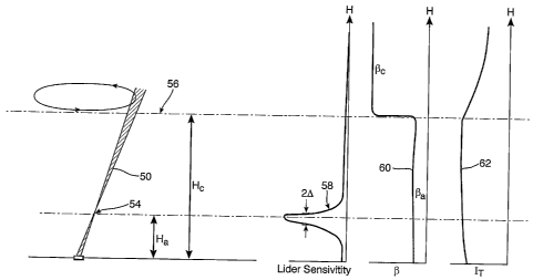
Referring to figure 5, the transmit and receive beams 50 of an upward pointing
lidai
system are illustrated. The transmit and receive beams are focussed on a
certain probe
volume 54 at a height 11, above the ground. Clouds 56 are also present at a
height
above ground level. The lidar sensitivity, scattering efficiency and transmit
beam power
and are shown as a function of the height above ground level by curve 58,
curve 60 and
curve 62 respectively.
It is also possible to estimate the amount of scatter from the probe volume
and cloud in a
more quantitative manner. In particular, it is possible to express the total
scattering from
the normal atmosphere (Sa) and the cloud (Se) as:
./.(11).A =
S oc . dh (3a)
*) a¨ Ha )2 + A2
42 (OA
S c c. dh (3b)
.11-1c (h¨ H ci)2 +A2
where h is the height above ground level, A is the change in height away from
focus that
leads to a 3dB (i.e. factor of two) reduction in sensitivity, Da and Pc are
the scattering
coefficients of the normal atmosphere and the cloud respectively and IT(h) is
the power
of the beam as it passes height h.
Figure 6 illustrates the ratio of the return signal from the cloud region and
the sub-cloud
region, as a function of the cloud to atmosphere scattering ratio, for a
system focussed at
a height of 100m for three different cloud heights (300m, 400m and 500m). An
attenuation length of 50m has been assumed for light penetrating the cloud. As
outlined
above with reference to figure 5, it should be remembered that the return
signal from the
sub-cloud atmospheric region is dominated by the return signal from the probe
volume.
22
CA 02562924 2006-10-17
WO 2005/114253 PCT/GB2005/001943
Hence, for values of Sc/Sa<<1, the aerosol return dominates and the
contribution from
cloud can be ignored. However, it can be seen from figure 6 that, in certain
circumstances, the cloud signal dominates the received signal. In other words,
as the
Sc/Sa ratio approaches unity the problem of the cloud signal dominating the
received
=
signal becomes increasingly severe.
Figures 5 and 6 show that although the lidar is most sensitive to light
returned from the
probe volume, a strong signal can be returned from clouds despite the fact
they are
located a significant distance from the probe volume. This means that, under
certain
conditions, the measured wind speed can be incorrect as the speed of the
clouds
dominate the return signal (rather than the wind speed at the chosen
altitude). This
problem has been found to be most severe when the lidar is focused at the
upper limit of
its range, when the aerosol back-scatter from the air below the cloud-base is
low and
when the cloud-base is low.
The effect of low cloud cover on the Doppler spectra acquired for a particular
point of a
conical scan using a fibre based lidar of the type describe above is
illustrated in figure 7.
It can be seen that in addition to the peak 70 which arises from back-scatter
from the
probe volume, a second peak 72 is present due to the strong back-scatter from
the clouds.
Typically the second peak is at higher velocities because clouds generally
move at a
greater speed than wind in the vicinity of the ground. However, as described
in more
detail below, this is not always the case.
An automated fitting routine of the type described with reference to figure 3
above will
typically output incorrect wind speed data if the second peak 72 is present.
For example,
if the second peak 72 dominates the spectra, the fitting routine is likely to
simply ignore
the smaller peak and will provide output data indicative of the speed of cloud
movement.
Alternatively, if the two peaks are of similar magnitude, the fitting routine
will typically
attempt to find a "best fit" curve for the two peaks which will provide a wind
speed
value that is somewhere between that of the probe volume and cloud base. In
both cases,
this introduces a significant and unknown error into the acquired wind speed
data. In the
case of unattended systems, it is not known when such an error is present
(i.e. the
23
CA 02562924 2006-10-17
WO 2005/114253 PCT/GB2005/001943
presence of a low cloud base typically occurs unpredictably) and thus the
level of
uncertainty associated with acquired data is also unknown.
Previously, weather conditions would have been monitored to identify the
occurrence of
a significant cloud return signal based on real-time observation of the actual
cloud
conditions. Alternatively, operators could have periodically monitored certain
characteristics of the wind spectra; for example, the acquired Doppler spectra
could be
checked for the presence of "double peaks". Although manual techniques can
provide
acceptable results, the cost of providing an operator (either "on-site" or for
analysing
acquired data off-line) is prohibitive.
One technique that has been found for overcoming problems associated with
cloud
returns is to monitor cloud height using a ceilometer. Referring to figure 8,
a
anemometer 80 is shown that includes a laser ceilometer 82 and a wind-
profiling fibre
lidar 84 of the type described above. The ceilometer 82 provides measurements
of
atmospheric backscatter as a function of altitude which is used to compute the
relative
strengths of the cloud and aerosol signals for each lidar measurement.
Ceilometers are known, and several systems are commercially available; for
example the
Vaisala (registered trademark) CT25K (supplied by Vaisala Oyj, Helsinki,
Finland), or
the Mesotech CBME40/80 (supplied by Mesotech International Inc., Sacramento,
U.S.A.). These systems transmit an upward-looking pulsed laser beam into the
atmosphere, and use time-of-flight information to measure the backscatter as a
function
of altitude. Normally such systems process the acquired backscatter data to
provide a
measure of cloud height and are used in the vicinity of airports and the like.
However,
the back-scatter profile measured by such apparatus may be directly extracted
and used
to improve anemometer performance as described below.
The ceilometer 82 is co-located with the lidar 84 and its output, in the form
of a back-
scatter profile, is fed to the computer of the lidar system for analysis. A
calculation is
then performed using the back-scatter profile to assess the probability of
there being
cloud related problems. In other words, the sensitivity of the lidar 84 as a
function of
height for a given focus altitude is known. The relative strength of the cloud
and probe
24
CA 02562924 2006-10-17
WO 2005/114253 PCT/GB2005/001943
volume return signals can thus be predicted using equations 3a and 3b and the
back-
scatter profile measured by the ceilometer. In this manner, wind speed data
affected by
cloud returns can be eliminated from the acquired data thereby leaving only
reliable
measurements of wind speed.
In the simplest configuration, the output of the calculation would be a
measure of the
relative strengths of the cloud and aerosol signal returns, from which a
confidence level
in the validity of each particular wind speed measurement can be assigned. In
many
cases, a simple "0" (invalid - cloud signal dominates) or "1" (valid - aerosol
signal
dominates) is sufficient. Alternatively, a measure of the uncertainty
as'sociated with each
wind measurement can be assigned.
Ideally, the ceilometer would execute the same conical scan as the lidar in
order to
ensure the same patches of sky are interrogated. However, an assessment based
on an
unscanned, upward looking ceilometer will typically provide sufficient
information. It
should also be noted that most commercially available ceilometer systems
operate using
a laser wavelength of around ijim whilst the fibre lidar system described
above operates
at 1.55pm. However, the backscatter profile does not differ significantly at
these two
wavelengths and any difference can be reduced by appropriate calibration.
The use of a ceilometer provides an unambiguous measure of atmospheric
scattering
profile, but it has also been found to be possible to analyse the Doppler
spectra acquired
by the lidar system to ascertain a measure of the uncertainty that is
associated with a
particular wind speed measurement. For example, higher complexity peak
detection
. techniques could be used to analyse the Doppler spectra and any high speed
cloud related
signals could be removed from the data or the presence of two or more peaks
could
trigger a simple "0" code of the type described above to indicate that the
cloud signal
appears to dominate the acquired data.
As an alternative to using a ceilometer, data from the coherent lidar could be
used to
determine the backscatter profile. For a focused CW system of the type
outlined above,
and in conditions of uniform scattering level (i.e. when 13 does not vary with
height), the
total return signal power is virtually independent of the range at which the
lidar is
CA 02562924 2006-10-17
WO 2005/114253 PCT/GB2005/001943
focused. This approximation only breaks down when the range approaches the
maximum
value at which a beam waist can be produced. Hence, a measure of scattering
(i.e. p) as a
function of height can be assessed from any observed variations in signal
strength as the
lidar focus is changed. The coherent lidar can thus be arranged to determine a
measure of
the atmospheric backscatter profile, and in particular any contribution to the
return signal
from cloud, by obtaining a succession of wind speed data from different
heights. As
described in more detail below, any returns from the cloud base will also have
a
substantially invariant Doppler shift as the lidar range (e.g. focus) is
changed.
The data required to determine the backscatter profile may be acquired during
normal
wind speed measurement operation, or via the intermittent running of a
separate
backscatter measurement routine. In either case, the total integrated power in
the return
signal is evaluated from a succession of spectra acquired at a number of
different heights
(for example 25m, 50m, 100m, 200m, 400m). Typically, the acquisition of such
data will
take less than one minute and, if necessary, can be repeated many times in
order to
acquire adequate statistics. The acquired returned power versus height can
then be
converted to a plot of backscatter versus height via deconvolution with the
spatial
sensitivity curve (instrumental function) of the lidar taking into account the
variation of
the instrumental function with height.
This scheme has the advantage that the backscatter is always assessed at the
correct laser
wavelength and that the measurement is carried out in the most appropriate
region of
space (e.g. in the same cone in which the lidar is scanned for the wind
measurements).
The spatial resolution will, however, typically be lower than that which can
be obtained
using a pulsed system such as a ceilometer.
As described above, under unfavourable weather conditions the contribution to
the
Doppler signal of an upwardly pointing lidar system may contain returns from
cloud that
contaminate, or even dominate, the return signal from aerosols in the probe
volume at the
height of interest. As described above, under "normal" wind profile conditions
(i.e. when
the cloud has a higher velocity than the wind in the lower atmosphere) this
can lead to an
overestimate of wind speed. The severity of the cloud signal effect on
measured wind
26
CA 02562924 2006-10-17
WO 2005/114253 PCT/GB2005/001943
speeds has been found to increase for low cloud height, high lidar range
settings and
when there are low aerosol densities at the desired probe volume height.
It has been found that wind speed errors introduced by the presence of cloud
returns can
be reduced by identifying the presence of such a cloud return and removing its
contribution from any relevant Doppler spectra. This is possible because cloud
returns
have been found to possess a number of characteristics that allow them to be
distinguished from aerosol returns at the desired probe volume. Firstly, the
velocity of
cloud is usually higher than the velocity of wind in the sub-cloud region.
Furthermore,
the spectral width of the Doppler peak associated with cloud returns is
typically narrower
than the peak that is associated with returns from a sub-cloud region. In
addition, it has
also been found that the Doppler peak height (i.e. the peak intensity of the
returned
signal) associated with cloud returns has a clear dependence on the lidar
range (i.e. the
height of the probe volume above the ground) whilst the Doppler shift of any
such peak
(which is related to the cloud velocity) is substantially independent of the
height at which
the lidar is focused.
Referring to figures 9 to 11, a technique is described for reducing errors in
measured
wind speed that are introduced when the lidar is operated in the presence of a
low cloud-
base.
Figure 9 illustrates the horizontal wind speed measured by a ground based,
conically
scanned monostatic lidar system over a 20 minute period. Lines 100, 102, 104,
106 and
108 show the measured wind speed at heights of 300m, 150m, 100m, 50m and 25m
respectively. The cloud base was observed to be at a height of around 300m for
the
duration of the measurements.
As described above with reference to figures 3 and 4, each wind velocity value
at each
height is determined by acquiring multiple Doppler spectra (of the type shown
in figure
3) at various points around the scan cone. Line of sight velocity values are
then
determined by calculating the centroid of each spectrum above a pre-determined
threshold. The line of sight velocity values extracted from the spectra are
fitted to the
expressions described in equations (1) and (2) allowing horizontal and
vertical wind
27
CA 02562924 2006-10-17
WO 2005/114253 PCT/GB2005/001943
speed components to be determined. Figure 9 illustrates the horizontal wind
speed
components calculated in such a manner for a number of heights above the
ground
without any attempt to correct for returns from the cloud base. It can be seen
from figure
9 that the measured wind speeds at 100m (line 104) and 150m (line 102) appear
very
similar to the measured wind speed at 300m (line 100).
Referring to figure 10, the effect of cloud return contamination on wind speed
measurements is illustrated and a technique for reducing such contamination is
described.
Figure 10a shows the Doppler spectrum for one measurement point at a
measurement
height of 150m. The Doppler spectrum can be seen to contain a broad peak 110
which
corresponds to the return signal from the probe volume (i.e. the region 150m
above the
ground) and also a sharp peak 112 that arises due to returns from the cloud
base (which
is at 300m). Extracting a line of sight wind velocity value from the Doppler
spectrum of
figure 10a by calculating the centroid of the spectra above a pre-determined
threshold
(i.e. using the technique described with reference to figure 3) will, in this
low cloud base
example, provide a wind velocity value that does not truly represent the
velocity at the
desired probe volume height of 150m. In other words, any wind speed calculated
in the
manner described above using the entire Doppler spectrum may not be indicative
of the
true wind velocity in presence of a low cloud base.
Referring to figure 10b, the Doppler spectrum for a measurement point at a
height of
300m above the ground is shown after a suitable thresholding step has been
applied. The
spectrum of figure 10b was acquired at substantially, the same scan angle as
that used to
acquire the spectrum of figure 10a. The spectrum shown in figure 10b contains
a single,
sharp, peak 114 that arises due to back-scatter of the laser radiation from
the cloud. It can
be seen from figures 10a and 10b that the height (i.e. peak return intensity)
Of the cloud
peak 114 of figure 10b is greater than that of the cloud return peak 112 of
figure 10a, but
that the Doppler shift of both peaks is almost identical.
The spectrum of figure 10b is subtracted from the spectrum of figure 10a to
produce the
modified spectrum shown in figure 10c. Note that the spectrum of figure 10b is
28
CA 02562924 2006-10-17
WO 2005/114253 PCT/GB2005/001943
thresholded prior to the subtraction step to prevent additional noise being
introduced to
the modified spectrum. A line of sight wind speed velocity is calculated from
the data of
figure 10c by determining the centroid of the spectrum above a pre-determined
threshold. It can be seen that the cloud peak is removed from the modified
data of figure
10c and hence the calculated line of sight wind velocity value reflects the
true wind
speed at the probe volume (i.e. at 150m above the ground). In other words, the
wind
speed measurements have been corrected to remove any deleterious effects due
to cloud
base returns.
The data correction technique described with reference to figure 10 was
repeated for
each of the line of sight Doppler spectra from which the wind speed data at
heights of
25m, 50m, 100m and 150mof figure 9 were calculated. The Doppler spectra
acquired
from cloud returns (i.e. at a height of 300m) were used in the correction
process. The line
of sight velocity values extracted from the spectra were refitted to the
expressions
described in equations (1) and (2) allowing horizontal and vertical wind speed
components to be determined. It should be noted that the outlier removal
technique
described above was also applied during the line of sight velocity fitting
process. ,
Figure 11 shows the "corrected" horizontal wind speed components at heights of
25m
(line 128), 50m (line 126), 100m (line 124) and 150m (line 122) and the cloud
velocity
data at 300m (line 100).
It can be seen from figure 11 that the variation in wind velocity with
altitude is more
representative of the actual wind profile during the measurements. In
particular, the
"bunching" together of the higher altitude wind speed measurements (e.g. 100m,
150m
and 300m) seen in figure 9 has been removed. This method thus removes cloud
effects
from wind speed measurements without relying on the cloud moving at a greater
velocity
than wind below the cloud base.
A number of variations to the above method would now be apparent to the
skilled
person. For example, it would be possible to:
(i) arrange the lidar to acquire Doppler spectra at an additional height (e.g.
300m) after
measurements at the maximum height of interest (say 150m).
29
CA 02562924 2006-10-17
WO 2005/114253 PCT/GB2005/001943
(ii) For each azimuth angle (around scan) subtract the 150m spectrum from the
300m
spectrum thereby producing a resulting spectrum with a large positive
component due to
cloudbase returns (if there are any).
(iii) Apply suitable thresholding to identify bins occupied by the cloud.
(iv) Eliminate the cloud component by rejecting all bins in the 150m (and
lower altitude)
spectra that correspond to the bins occupied by the cloud.
(v) Run centroiding on the corrected spectra and fit data as described above
to determine
line of sight velocity values.
On consideration of the teachings contained herein, the skilled person would
also
appreciate the various modifications and alternative methods that could be
applied to the
above described techniques to reduce cloud base effects on lidar wind speed
measurements.
It should be noted that the above data analysis techniques are not only
applicable to
upwardly pointing lidar systems. The techniques may be applied to wind speed
measurement lidar systems of any orientation. Furthermore, it should be noted
that
processing of Doppler spectra may be performed in real time (e.g. by the
computer
controlling the lidar) or off-line using previously recorded data.
Referring to figure 12, a Doppler wind lidar 90 mounted on the nacelle of a
wind turbine
92 is shown. The lidar 90 is pointed upwind, through the region swept by the
blades of
the turbine, to provide advance wind speed measurements. The lidar 90 may be
scanned,
e.g. a conical scan may be performed, to measure different wind velocity
components.
Such advance wind speed measurements may be used for turbine control or to pro-
vide
gust warnings to protect the turbine from damage due to gusts of wind.
The reliability of wind speed data acquired from the lidar 90 can, as with
upwardly
pointing systems, also suffer from erroneous wind speed data points. In
particular, solid
objects (birds, insects, aircraft etc) may move across the field of view of
the lidar and
thus provide a strong return signal even when a long distance from the probe
volume.
The techniques described above with reference to figure 4 in which "outlier"
data points
are removed are thus also advantageous when applied to horizontally pointed
lidar
CA 02562924 2006-10-17
WO 2005/114253 PCT/GB2005/001943
systems. In the case of turbine mounted lidar systems, such techniques are
particularly
advantageous as they allow the removal of any spurious data points that are
produced by
reflection of light off the turbine blades, reflections from the blades of
other turbines in
the wind farm or from any wiper system used to keep the lidar output optics
free from
rain or dirt.
Furthermore, although the problems associated with a low cloud base are
unlikely to
prove problematical with a horizontally pointing system, fog banks or clouds
of smoke
may produce analogous errors. In such cases, the provision of a ceilometer or
cloud base
correction technique as described above would also prove advantageous.
31