Note: Descriptions are shown in the official language in which they were submitted.
CA 02573182 2007-01-09
WO 2006/005193 PCT/CA2005/001102
1
METHOD FOR POSITIONING USING GPS IN A RESTRICTIVE COVERAGE
ENVIRONMENT
BACKGROUND OF THE INVENTION
Field of the Invention
The invention relates generally to GPS receivers, and in particular, to GPS
receivers
operating in restrictive coverage environments.
Background Information
BACKGROUND
Surveying or other measurement systems that use fixed-position GPS receivers
for
precise position information are hindered and, in some cases, prevented from
operating in
"restrictive coverage" environments. Restrictive coverage environments are
those in
which direct GPS satellite signals are corrupted by indirect signals
(multipath) and, in
some cases, particular direct signals are entirely blocked. An example of a
restrictive
coverage environment is one in which obstructions, such as foliage, landscape,
buildings
and so forth, obscure portions of the sky views of the respective GPS
receivers and/or
provide large multipath signals to the GPS receivers.
In a restrictive coverage environment, the set of signals received by the GPS
receiver will include some corrupted signals as well as some purely indirect
ones, that is,
reflected signals that correspond to the blocked line-of-sight signals. The
receiver
operating in a conventional manner uses all of the received signals to produce
positions,
and may thus produce positions that are accurate only to within a number of
meters. Also,
there will be times when the GPS receiver does not have a sufficient number of
GPS
satellites in view to even compute a position. Accordingly, the surveying or
other
measurement systems may not be able to determine the position (latitude,
longitude and
height) to within the required tolerances for some applications.
As described below, we have come up with a way to process the range
information
provided by the GPS receivers in a restricted coverage environment, to
determine the
respective positions of the GPS receivers to within the required tolerances.
CA 02573182 2007-01-09
WO 2006/005193 PCT/CA2005/001102
2
SUMMARY OF THE INVENTION
The invention is a system that determines GPS positions to within tight
tolerances
by batch processing range information from GPS receivers. The system includes
a base
GPS receiver with a substantially unobstructed view of the sky. The base GPS
receiver
and the other GPS receivers in the measurement area produce range information
based on
the satellite signals that the respective receivers can track at a given time,
and provide the
range information to a data recording and processing center. The range
information
includes both code and carrier measurements for each of the signals that are
being tracked
by the respective GPS receivers. The center collects the range information
over an
extended period of time, for example, hours, days or weeks, and then batch
processes the
collected information, to calculate the precise latitude, longitude and height
of the receiver.
The center also calculates the quality of the collected range information, to
ensure that the
information used in the batch position calculations is sufficiently reliable,
as discussed in
more detail below.
As long as a given GPS receiver has tracked at least two satellites
simultaneously
for 3 or 4 relatively short time intervals at different sky locations during
the extended
period, the batch processing of the range information produces the position of
the GPS
receiver to within the relatively tight tolerances that are required for
applications such as
surveying or seismic measuring. The batch processing allows the system to
calculate the
precise position of the GPS receiver without requiring that the GPS receiver
continuously
track the GPS satellite signals from multiple satellites and/or track the
signals from the
same set GPS satellites.
The data processing center batch processes the range data collected from a
given
GPS receiver over the extended period, to compute a single position, i.e.,
latitude,
longitude and height, and an associated position covariance. The batch
processing
involves multiple passes through the collected range data, with a first pass
using all of the
collected data, that is, all of the pseudorange and carrier phase information,
to 'produce a
global position estimate that is expected to be accurate to within 30 to 60
meters. As
discussed, the accuracy is adversely affected by the overall quality of the
range data.
CA 02573182 2007-01-09
WO 2006/005193 PCT/CA2005/001102
3
As a next pass through the data, the data recording and control center refines
the
calculated position and position covariance using only the carrier phase
measurements,
which are less susceptible to multipath interference. The receiver starts with
the estimated
position and position covariance from the first pass and, in what is a
computation intensive
manner, estimates carrier cycle ambiguities to determine updated estimated
positions and
associated position covariances. The estimated position and the associated
position
covariance are updated at every code epoch in which two or more satellites are
in view of
the receiver, that is, when double differences can be calculated to estimate
the carrier cycle
ambiguities. The accuracy of the position estimate at the end of the second
pass is
expected to be within 3 to 6 meters, with most of the error attributable to
the height
component.
The third pass through the data holds the position fixed to the best estimate
from
pass two and looks for growth in the residuals calculated using the carrier
phase
measurements and the estimated ambiguities that are based on double
differences using
measurements from the base GPS receiver. The processing then selects for
further
processing the data that are associated with little or no residual growth, and
flags as invalid
the data associated with relatively large residual growth. The processing may
also
selectively weight various data used in the further processing.
The processing then recalculates the estimated position based on the results
of the
third pass. The system eliminates from the calculations the measurements that
are flagged
as invalid and assigns appropriate weights to the remaining measurements, to
produce a
new position estimate and an associated position covariance.
The processing system next holds the position and position covariance fixed at
the
new estimates and repeats the third pass, that is, the processing step of
determining the
validity of and weightings for the measurements based on the associated
residuals. In this
step the system may accept as valid particular measurements that showed
perceived
movement relative to the prior estimated position and position covariance but
do not with
respect to the new estimates. The processing system then determines a next
estimated
position and associated position covariance using the updated weighting and
validity
determinations, and continues iterating in this manner, i.e., determining new
weightings
and a next estimate of position, until the estimated position changes by less
than a
CA 02573182 2012-10-02
64421-828
4
predetermined threshold between iterations. The result is a position that is
accurate to within
the tolerances required for making the desired measurements.
In one aspect of the present invention, there is provided a GPS system,
including: a base GPS receiver with an antenna that has a clear view of the
sky; one or more
remote GPS receivers; a data processing center that collects range data from
the base and
remote GPS receivers over a plurality of hours and calculates single positions
and associated
position covariances of the respective GPS receivers, the data processing
center further batch
processing the data received from the respective remote receivers in a
plurality of passes
through the data using floating ambiguity filters for processing carried phase
measurements
included in the range data, the floating ambiguity filters after the first
pass being initialized
with estimated positions that have been previously calculated, wherein in a
first pass of said
plurality of passes, said data processing center uses all the collected data;
wherein in a second
pass of said plurality of passes, said data processing center refines said
calculated position and
position covariance using only the carrier phase measurements; wherein in a
third pass of said
plurality of passes, said data processing center holds a position fixed to the
best estimate
calculated during said second pass, and looks for growth in double different
carrier residuals
calculated using the carrier phase measurements and estimates double
differences carrier
ambiguities using measurements made by said GPS receiver; wherein said data
processing
center selects for further processing the data which is associated with little
or no residual
growth and flags as invalid the data associated with relatively large residual
growth; wherein
said data processing center recalculates the estimated position based on the
results of said
third pass and repeats said third pass and recalculating estimated position
based on the results
until the recalculated position and the previously recalculated position
differ by less than a
predetermined threshold.
In another aspect of the present invention, there is provided a method of
calculating GPS position in a restrictive coverage environment, the method
including the steps
of: receiving range data associated with a clear view of the sky from one or
more base GPS
receivers; receiving range data from one or more remote receivers that have
restricted views
CA 02573182 2012-10-02
64421-828
4a
of the sky; determining a single position and an associated position
covariance of a given
remote receiver by batch processing the range data received over a plurality
of hours in a
plurality.of passes through the data using a floating ambiguity filter that
after a first pass
through the data is initialized with a previously calculated estimated
position; wherein in a
first pass of said plurality of passes, a data processing center uses all the
collected data;
wherein in a second pass of said plurality of passes, said data processing
center refines said
calculated position and position covariance using only the carrier phase
measurements;
wherein in a third pass of said plurality of passes, said data processing
center holds a position
fixed to the best estimate calculated during said second pass, and looks for
growth in double
difference carrier residuals and estimates ambiguities that are based on
double differences
using measurements made by the said GPS receiver; wherein said data processing
center
selects for further processing the data that are associated with little or no
residual growth and
flags as invalid the data associated with relatively large residual growth;
wherein data
processing center recalculates the estimated position based on the results of
said third pass and
repeats said third pass and recalculating estimated position based on the
results until the
recalculated position and the previously recalculated position differ by less
than a
predetermined threshold.
CA 02573182 2012-10-02
64421-828
4b
BRIEF DESCRIPTION OF THE DRAWINGS
The invention description below refers to the accompanying drawings, of which:
Fig. 1 is a functional block diagram of a system constructed in accordance
with the
current invention; and
Fig. 2 is a flow chart of the batch processing operations performed by the
system of
Fig. 1.
DETAILED DESCRIPTION OF AN ILLUSTRATIVE EMBODIMENT
Referring now to Fig. 1, a positioning system 100 includes a plurality of GPS
receivers 6 that supply range information, that is, pseudoranges and carrier
measurements,
to a data recording and control center 12 through signal receivers 7 that are
located in
selected locations over a site of interest. The signal receivers 7 are
connected to the center
by cables 14. The center 12 includes one or more workstations 2 and data
storage devices
1 that retain and process the range information. The signals fiom various
cables 14 (only
one of which is shown in the drawing) are supplied to the one or more
workstations 2
through a multiplexer 4, which operates in a conventional manner. The GPS
receivers 6
are sometimes referred to herein as "remote receivers."
The data recording and control center 12 further includes a base GPS receiver
3 that
receives signals from various GPS satellites 9 using a base GPS antenna 13,
which is
positioned to have a clear view of the sky. An elevated tower 5 may be
necessary to
provide the GPS antenna 13 with a clear view to the sky. As depicted in the
drawing,
certain or all of the GPS receivers 6 are located under or near various trees
11, such that at
any given time the signals 10 from GPS satellites 9 in certain sky locations
may be
unavailable or weakened at various GPS receivers.
The base GPS receiver 3 acquires and tracks the signals 10 from each of the
GPS
satellites 9 in view. The GPS receivers 6 produce range information based on
the satellite
signals that the respective receivers can track at a given time, and provide
the range
CA 02573182 2007-01-09
WO 2006/005193 PCT/CA2005/001102
information via the signal receivers 7 to the data recording and control
center 12. As
described in more detail below with reference to Fig. 2, the center collects
the range
information over an extended period of time, for example, hours, days or
weeks, and then
batch processes the collected information, to calculate the precise latitude,
longitude and
5 height of the receiver. The center also calculates the quality of the
collected range
information, to ensure that the information used in the batch position
calculations is
sufficiently reliable.
As long as a given GPS receiver 6 has tracked at least two satellites
simultaneously
for 3 or 4 relatively short time intervals at different sky locations during
the extended
period, and the GPS receiver has not moved during the data collection period,
the batch
processing of the range information calculates the position of the GPS
receiver to within
the relatively tight tolerances required for applications such as seismic
measurement and
surveying. The batch processing thus allows the system to calculate the
precise position of
the GPS receiver without requiring that the receiver continuously track the
GPS satellite
signals and/or track the signals from the same set of GPS satellites.
The data recording and control center 12 batch processes the range
information,
making multiple passes through the data using a floating ambiguity filter 8.
As discussed
in more detail below, the filter operates in certain of the passes with a
position and position
covariance matrix that is not reset when the carrier ambiguities are reset.
This allows the
filter to use the full history of observational information, here the carrier
information, to
estimate the stationary position of a given receiver. The filter is thus not
limited to using
observational information associated with discrete blocks of continuous
carrier phase
measurements.
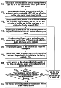
Referring also to Fig. 2, the batch processing includes the following passes
through
the collected range information:
Pass 1: All of the available data from a given GPS receiver 6 (pseudoranges
and carrier
phases) are processed in a known manner using the floating ambiguity filter 8,
to produce
a first estimated position (Step 200). The output of this pass is a position
with an expected
accuracy of between 30 and 60 meters. The data is produced based on signals
from the
satellites that are in the view of the receiver at various times over an
extended time period,
CA 02573182 2007-01-09
WO 2006/005193 PCT/CA2005/001102
6
that is, over a number of hours, days, and so forth. Generally, it is expected
that range data
will be collected over a period of between 8 and 24 hours. The remote GPS
receiver's
restricted view of the sky, because of foliage or other partial coverage, may
result in the
receiver having the same set of satellites in view over only a small portion
of the extended
period and/or having only one satellite in view at particular times. Further,
some of
satellite signals may be distorted by large multipath components attributed to
signals that
are reflected by the obstructions that obscure the skyviews of the GPS
receivers and/or
nearby structures, and so forth. Accordingly, certain of the data may not be
particularly
reliable.
Pass 2: The floating ambiguity filter 8 is initialized with the estimated
position derived
during pass 1. In this pass the pseudorange measurements are not used, and a
refined
position is computed using only the carrier phase measurements (Step 202). The
position
and position covariance are updated every code epoch during which two or more
satellites
are available to, that is, in the view of, the receiver. The filter is reset
after a cycle slip or
whenever fewer than two satellites are available for at least one code epoch.
Each time
the filter is reset, the system uses the last best estimates of position and
position covariance
as initial values (Step 204). In this manner, the position information is
retained while the
ambiguity information is essentially discarded. The accuracy of the final Pass
2 position is
between 3 and 6 meters, with most of the error associated with the height
component.
Pass 3: The position and position covariance are held fixed in this pass, such
that all of the
observational carrier data may be used (Step 206). The fixed position is the
final position
derived in Pass 2. The position covariance matrix is held to be a diagonal
matrix, with
very small elements (i.e. 0.00000001 m2). With the position held fixed, the
system
estimates double difference carrier ambiguities using observations from the
base receiver,
and determines associated double difference carrier residuals (Step 208).
Based on an
analysis of residuals and their growth, the data are treated as invalid or
weighted
accordingly (Step 210).
In this pass, the floating ambiguity filter is modified to reset carrier
ambiguities only
if a carrier cycle slip, that is, a loss of lock, is detected. The residuals
are allowed to grow
without limit, as long as the carrier measurements are continuous. The
residuals generated
in this pass are used to create a series of signal quality indicators that
are, in turn, to be
CA 02573182 2007-01-09
WO 2006/005193 PCT/CA2005/001102
7
used in the subsequent pass. The signal quality indicators allow appropriate
weighting
values to be assigned to the carrier measurements from each satellite at each
code epoch.
The carrier measurements may be assigned full weight if the following
conditions are met:
a) The time since the last cycle slip exceeds a first predetermined threshold.
b) The sum of squares of the residuals of the carrier measurement falls below
a
normalized threshold over an interval of continuously available measurements.
c) The growth rate of the sum of squares of the residuals does not exceed a
second
predetermined threshold over an interval of continuously available
measurements.
If all of the conditions are not met, the series of carrier observations for
the entire
interval between cycle clips, or lock breaks, are flagged as invalid. If a
series of carrier
measurements for an interval between cycle slips is deemed valid, that is, the
conditions
are met, some portion of the measurements in that interval (not including the
measurements at the end points of the interval) may be de-weighted. The de-
weighting is
applied to prevent correlated multipath errors, i.e., non-white noise, on the
continuous
measurements from inappropriately affecting the estimated position solution.
The de-
weighting may, for example, take the form of using only a portion of the
measurements
over a particular code epoch, i.e., one out of every four measurements, or
using a larger
standard deviation in the associated calculations.
The system thus creates a weighting table (not shown), with flags for each PRN
code at each code epoch. These flags direct how the measurements will be used
in a
subsequent pass through the data. The flags may simply be "valid" or
"invalid," or they
may specify to what extent the measurements should be de-weighted.
Pass 4: The last estimated position and position covariance are used to
initialize the
floating ambiguity filter for this pass (Step 212). The filter then uses the
weighting table
to assign weights to the carrier observations it uses, and eliminates from the
calculations
those observations flagged as "invalid." The system produces a new estimated
position
and position covariance (Step 214),.which is then subject to the validation
described in
Pass 5 below.
CA 02573182 2007-01-09
WO 2006/005193 PCT/CA2005/001102
8
Pass 5 and above: Pass 5 is the same as Pass 3, using the last estimated
position as the
fixed position (Step 218). The double differenced carrier residuals are thus
computed and
tested as described in Pass 3, and the validity or non-validity of the
respective observations
are reestablished. A new weighting table is then created and a new estimated
position and
position covariance are calculated in the same manner as Pass 4. The system
then
determines if the newly calculated position differs from the last calculated
position by
more than a predetermined threshold (Step 216). If so, the system repeats Pass
5 (Step
218). Otherwise, the system uses the new estimate as the calculated position
(Step 220).
For example, when the height, which is the value in which most of the error
occurs
changes by less than 0.05 m between iterations, the solution is deemed to have
converged
and processing is ended.
Test Description
To test the process described above, an extremely restricted test environment
was
selected. The test site was the UBC Malcolm Knapp Research Forest in Maple
Ridge, BC.
A total of 8 NovAtel OEM4-G2L receivers were deployed in series in an old
growth
section of the forest. The forest was very dense, with very tall trees, over
50 meters in
height, and thick underbrush. The moisture level was also very high, as it
rained
throughout the majority of the test, saturating the foliage with water. The
rover GPS
receiver antennae were set up very close to the ground. They were mounted on
threaded
rod, within 3 inches of the ground. A 22 hour data set was collected. A
NovAtel OEM4-
G2L base station was set up in a clearing with an unobstructed view of the
sky.
In addition to providing an excellent coverage environment, the UBC research
forest
also has an existing survey network in it, established by FERIC as a test
range. Since
conventional GPS performance is quite poor, particularly in height, under
heavy foliage,
an independent reference for the receiver positions was required. A
traditional survey was
performed, working off of the FERIC test range points, using a total station
for the
horizontal positioning and a spirit level for the vertical component. The
FERIC survey
network is supposed to be accurate to 10cm horizontally, with heights given to
the even
meter only. The horizontal survey performed for this test agreed to the FERIC
network to
0.20 in or better. The level loop closed to 0.017 in, so the vertical control
should be better
CA 02573182 2007-01-09
WO 2006/005193 PCT/CA2005/001102
9
than 0.01 m at each point. All positional errors given in this document are
with respect to
this ground survey.
Test Results
The 8 rover GPS receivers were positioned in areas with heavy foliage
canopies, in
ravines, in proximity to large trees and/or stumps, and so forth. Accordingly,
the system
was tested with the receivers in environments in which multipath signals were
prevalent
and sky views in most instances were limited. Table 1 summarizes the
positional errors of
the 8 rover GPS receivers.
Table 1: Position Errors Resulting from the Multiple Pass Process
Rover North Error East Error Height Error Total Positional Error
(m) (m) (m) (m)
A 0.04 -0.05 0.07 0.09
D 0.05 0.33 0.36 0.49
E -0.33 0.25 0.63 0.76
F -0.55 0.12 1.14 1.27
G -0.17 -0.05 0.13 0.22
H -0.27 -0.27 0.39 0.54
I -0.48 0.19 0.84 0.98
J -0.07 0.23 0.63 0.67
While the horizontal positioning results are better than what would be
achieved with
conventional processing techniques, the vertical results are most impressive,
with an
average height error of 0.52 m.
Table 2 summarizes the height errors and the number of passes required to
achieve
them.
CA 02573182 2007-01-09
WO 2006/005193 PCT/CA2005/001102
Table 2: Height Errors and Number of Passes Performed
Rover Height Error (m) Number of Passes
A 0.065 2
D 0.361 4
E 0.633 8
F 1.136 8
G 0.128 4
H 0.388 6
I 0.836 8
J 0.625 8
The level of improvement can be seen in the convergence of the height estimate
from pass
to pass, as shown in Table 3.
5 Table 3: Height Errors at end of Each Pass
Rover Pass 1 Pass 2 Pass 4 Pass 6 Pass 8
A 0.794 0.065 - - -
D 12.911 0.408 0.361 - -
E 5.752 0.903 0.565 0.621 0.633
F 12.123 1.89 1.48 1.141 1.136
G 13.148 0.086 0.128 - -
H 22.519 0.451 0.384 0.388 -
I 12.963 1.345 1.111 0.884 0.836
J 12.117 0.832 0.780 0.651 0.625
CA 02573182 2007-01-09
WO 2006/005193 PCT/CA2005/001102
11
As can be seen from the text results, the system calculates GPS positions that
are
within tolerances associated with applications such as surveying, seismic
measuring, even
for receivers that are located in what can be characterized as an extremely
restrictive
coverage environments. The number of passes through the data provided by a
given
receiver depends on the conditions at the location of the receiver, and thus,
on the
underlying reliability of the data.
The foregoing description has been limited to a specific embodiment of this
invention. It will be apparent, however, that variations and modifications may
be made to
the invention, with the attainment of some or all of its advantages. For
example, the base
GPS receiver observation data may be supplied by two or more GPS receivers
that have
partial views of the sky and together have a clear view of the sky, the
position covariance
may be fixed at other values that represent predetermined small thresholds for
relative
perceived movement, and so forth. Therefore, it is the object of the appended
claims to
cover all such variations and modifications as come within the true spirit and
scope of the
invention.