Note: Descriptions are shown in the official language in which they were submitted.
CA 02574573 2007-01-22
WO 2006/014750 PCT/US2005/025764
OFFSET-AZIMUTH BINNING FOR MIGRATION
AND VELOCITY ANALYSIS
INVENTORS: RUSSELL AARON KAPPIUS; EDWARD LOUIS JENNER
FIELD OF THE INVENTION
[001] The invention relates generally to the field of the 3D seismic data
acquisition. More specifically, the present invention relates to a method and
apparatus
to provide for efficiently and advantageously sorting and analyzing data for
three
dimensional (3D) seismic arrays of sources and receivers.
BACKGROUND OF THE INVENTION
[002] In 3D seismic prospecting, an areal array of seismic sources and
receivers
are positioned over an area of the earth's surface and seismic data are
collected in the
form of seismic traces generated by the receivers in response to acoustic
waves. This
is in contrast to two dimensional seismic prospecting wherein a linear array
rather
than an areal array of sources and receivers is utilized. In 3D as well as in
two
dimensional seismic prospecting it is desirable to "stack" a number of traces
(commonly called a common midpoint bin or gather) which correspond to a number
of source-receiver pairs which share a common midpoint position.
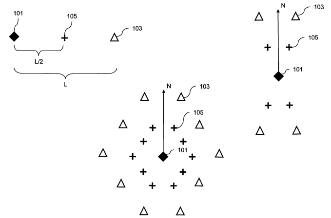
[003] Figure 1A illustrates a midpoint 105 positioned between a seismic source
101 and a seismic receiver 103. For any seismic source 101 with a receiver 103
there
is a midpoint 105 that is the seismic survey position where the received
signal data
will be positioned for data processing purposes. For compressional seismic
wave
processing the midpoints are positioned a distance L/2 in the source to
receiver
direction for a source to receiver offset distance of L. Other waveforms or
seismic
acquisition and processing considerations may dictate 'midpoints' at varying
locations, so the midpoints for the purposes of disclosure are for
illustrative purposes.
1
CA 02574573 2007-01-22
WO 2006/014750 PCT/US2005/025764
[004] In planning, collecting and processing a 3D seismic data, it is
desirable to
position the sources and receivers to optimize various conditions with respect
to fold,
offset and azimuth. Figure 1B shows the areal positions of a simple 3D
acquisition
geometry. A source 101 is positioned relative to seismic receivers 103 and the
midpoints 105 are situated between the source 101 and receivers 103. The
midpoints
105 are where the data traces are positioned relative to all the data traces
of the survey
for purpose of binning the data traces. Figure 1B illustrates a four-sensor
receiver
array. In modem practice, receiver arrays consist of hundreds or thousand of
receivers. Receiver arrays are referred to as "swaths" or "patches." Figure 1
may be
considered a "narrow-swath" because the azimuthal variation of source to
receivers is
relatively small when compared with Figure 1C. .
[005] Figure 1C illustrates a "wide-swath" receiver array acquisition
geometry. It
is termed wide-swath because the variation in acquisition of source to
receiver
azimuths for this geometry is much greater than illustrated in Figure 1B. The
various
geometries of source to receiver layouts or patches that comprise wide or
narrow
swath acquisition schemes varies greatly and is well known to practitioners in
the art.
[006] As is known in the acquisition and processing art, the survey area
localized
within an entire seismic survey designated for the collection of common
midpoint
positions from multiple source-receiver pairs is termed a common midpoint
"bin."
The data processing steps of organizing traces in bins is termed "binning." A
bin may
contain many traces from source-receiver pairs. The number of traces that goes
into a
bin is termed the bin's fold. The common midpoint gather (CMP) used herein for
purposes of an exemplary seismic data gather, although it is only one of many.
Common depth point (CDP) gathers, common reflection point gathers, common
image point gathers and common conversion point gathers are all examples of
seismic
gathers. For the CMP, the term "source-receiver pair" refers to a source
position and
receiver position located on opposite sides of a midpoint and spaced
substantially
equidistantly from the midpoint.
[007] Figure 2 illustrates the concept of how a midpoint bin is formed. A
plurality of source-receiver pairs in a seismic survey will have midpoints
that group in
2
CA 02574573 2007-01-22
WO 2006/014750 PCT/US2005/025764
the same vicinity of the survey. In Figure 2, sources lOlA, 101B and 101C with
their respective receivers 103A, 103B and 103C, contain midpoints that fall
relatively
close together, in a selected localized area, to form a midpoint bin. The
midpoints
that form this example midpoint bin are 105A, 105B and 105C.
[008] Source-receivers pairs from midpoint bins are further processed by
correcting statics problems and adjusting for velocity effects prior to
stacking.
Stacking of seismic traces corresponding to such source-receiver pairs
involves
summing of the traces after so as to enhance important reflection events in
the traces
and remove spurious noise which can obscure the reflection events. In other
words,
stacking enhances the signal to noise ratio.
[009] With respect to fold, it is desirable to have an adequate fold for each
common midpoint bin in order to give an acceptable signal to noise ratio in
the
resulting stacked trace. It may be desirable to have unifonnity of fold among
a
maximum number of common midpoint bins for a particular areal array. This
results
in a more uniform signal to noise ratio for the various stacked traces and
better
uniformity across the survey. With such a unifonn signal to noise ratio among
stacked
traces, variations of amplitude from trace to trace will be related to the
strength of
reflection events and not the difference in the number of traces being summed.
This
makes the seismic survey data a more accurate product.
[0010) Certain parameters which characterize a group of 3D source-receiver
pairs
corresponding to a particular common midpoint bin include fold, offset and
azimuth.
Fold refers to the number of source-receiver pairs sharing a common midpoint
for '
which traces are stacked. For example, if there are 16 source-receiver pairs
for a
particular stack, there is "16 fold" for the midpoint. Offset is simply the
distance
between the source and receiver of a particular source-receiver pair. Azimuth
is the
angular orientation of the source-receiver pair. More precisely, the azimuth
angle for a
particular source-receiver pair is the angle defined between the line along
which the
source-receiver pair lies and an arbitrarily selected direction such as true
east or north.
3
CA 02574573 2007-01-22
WO 2006/014750 PCT/US2005/025764
[0011] With respect to offset, it is desirable to have a variation of offsets
for the
source-receiver pairs corresponding to a particular common midpoint. The
different
offset values are utilized to derive velocity analysis corrections for the
traces being
stacked. Velocity analysis corrections are applied to seismic data to position
reflecting
events to their proper position in time. An "average stacking velocity" is
derived from
the velocity analysis corrections. Such a stacking velocity is used to correct
for
normal moveout among the traces. Maximizing the distribution of offset values
serves
to enhance the accuracy of the derived stacking velocity and thus also the
accuracy of
the resulting normal movement correction. Maximizing the distribution also
serves to
enhance the accuracy of Amplitude Variation with Offset (AVO) analysis which
can
be useful in determining rock and fluid properties.
[00121 With respect to azimuth, it desirable to have a maximum variation in
azimuth angles among the source-receiver pairs corresponding to a particular
common
midpoint. By having many different azimuth angles, the accuracy of 3D statics
solutions and velocity analysis is enhanced. Statics are corrections applied
to seismic
data to correct for low velocities (weathering velocities) of seismic waves
encountered in unconsolidated sediments near the earth's surface.
[0013] U.S. Patent No. 4,933,912 to Gallagher discloses a 3-D seismic
prospecting
method which employs an areal array of sources and receivers by which seismic
traces are generated. The areal array is segregated into a plurality of shells
and
angularly separated sections from which a preselected number n, of source-
receiver
pairs are selected for a particular common midpoint. By means of the shells
and
sections, the source-receiver pairs so selected have associated therewith a
wide range
of offsets and azimuth angles for the preselected fold nI. The seismic traces
corresponding to the selected source-receiver pairs are summed to give a
stacked trace
corresponding to the common midpoint.
[0014] U.S. Patent 5,963,879 to Woodward et al. discloses a method wherein
three
dimensional seismic survey data are acquired and processed using a hexagonal
sampling grid. The seismic data are grouped into hexagonal bins defined by the
hexagonal grid instead of into rectangular bins defined by a rectangular grid.
Method
4
CA 02574573 2007-01-22
WO 2006/014750 PCT/US2005/025764
and apparatus which bin the data, although described for square and regular
hexagonal grids, are also applicable to rectangles and hexagons of any shape.
Because
hexagonal binning requires fewer grid points than rectangular binning, survey
source
or receiver interval may be increased, which may help reduce survey cost.
[0015] U.S. Patent No. 6,026,059 describes processes for providing a data set
useful for performing analysis of reflection attribute variation among traces
in a
window of three-dimensional seismic data, wherein the traces have a reflection
point
assigned thereto and wherein the traces represent recordings from shot-
receiver pairs
having various azimuth angles. According to one embodiment, the process
comprises:
assigning an offset value to a plurality of traces; fitting a substantially
conical surface
having a major and a minor axis to the data of the traces within the window,
wherein:
the major axis of the cone represents the azimuth direction having the lowest
variation
in the reflection attribute, and the minor axis of the cone represents the
azimuth
direction having the highest variation in the reflection attribute; assigning
a coordinate
set to the surface, wherein the coordinate set is related to a survey geometry
of the
data; and comparing the reflection attribute variation as a function of offset
and
azimuth.
[0016] U.S. Patent No. 6,625,543 discloses a method wherein input seismic data
are
re-gridded to an arbitrary output grid by output-based azimuth moveout. An
input
seismic data set corresponding to an input grid is used to generate an
equivalent
output seismic data set corresponding to an output grid different from the
input grid.
Preferably, the output grid is divided into blocks, and each output grid block
is
assigned to one of a plurality of independent parallel processors. For each
output trace
corresponding to an output location, the contributions of plural input traces
to the
output trace are computed according to an azimuth moveout operator. The
contributions are then summed into the output trace.
SUMMARY OF THE INVENTION
[0017] The present invention comprises a method of choosing a cell structure
for
seismic gathers dictating a grid of azimuth-offset bins that can be of various
shapes
5
CA 02574573 2007-01-22
WO 2006/014750 PCT/US2005/025764
and sizes. Processes that use offset-azimuth information are optimized to
operate on
these cells of azimuth-offset bins and invert for seismic properties. The
method
provides for acquisition of 3D seismic data, selecting a seismic gather bin
for sorting
the data, selecting at least one cell structure for the gather bin that may or
may not be
space filling, and sorting the data in to the cell structure of the gather
bin. The cell
structures may be any shape including hexagonal, may be of variable sizes,
cells may
overlap and cells may be space filling or non-space filling.
BRIEF DESCRIPTION OF THE FIGURES
[0018] The present invention and its advantages will be better understood by
referring to the following detailed description and the attached drawings in
which:
Figure 1A illustrates a source, receiver and midpoint;
Figure 1B illustrates a narrow azimuth swath;
Figure 1C illustrates a wide azimuth patch;
Figure 2 illustrates a midpoint bin;
Figure 3A illustrates Common Midpoint Gather;
Figure 3B illustrates offset binning;
Figure 3C illustrates a radial binning;
Figure 4 illustrates hexagonal binning;
Figure 5 illustrates radial bins with variable sectoring;
Figure 6 illustrates Variable Circular Patches binning that consists of
multiple
circular offset-azimuth sample bins with variable area; and
Figure 7 illustrates Polygonal Patch binning that comprises any number of
arbitrary
polygons of varying size and shape.
Figure 8 illustrates a flow chart of an embodiment of the present invention.
Figure 9 illustrates schematically a system provided for the present
invention; and
Figure 10 illustrates an embodiment of the present invention.
[0019] While the invention will be described in connection with its preferred
embodiments, it will be understood that the invention is not limited thereto.
It is
intended to cover all alternatives, modifications, and equivalents which may
be
6
CA 02574573 2007-01-22
WO 2006/014750 PCT/US2005/025764
included within the spirit and scope of the invention, as defined by the
appended
claims.
DETAILED DESCRIPTION OF THE INVENTION
[0020] The present invention, herein referred to as Migration Offset-Azimuth
Binning (MOAB) provides for offset-azimuth binning of 3D seismic data for
migration, velocity analysis, AVO or any prestack, pre or post-migration
analysis.
Offset-binning of traces into common midpoint bins (or other types of seismic
gathers) is a well understood and widely practiced seismic processing step.
Offset
binning may be used to regularize seismic data for subsequent processing such
as
AVO analysis or as a space saving technique for data storage. In any of its
uses, it is a
straightforward and well understood practice.
[0021] The present invention provides a cell structure for bins of seismic
data. One
of the advantages is that the cell structure provided aids offset-azimuth
processing for
binned seismic data gathers. These cell structures may also be referred to
herein as
patches. The process of sorting data into groups is termed "binning." Data
that are
grouped together are then said to have been binned. For the present invention,
as the
data are binned into the seismic data gathers, they may contemporaneously be
binned
into a selected cell structure. The common midpoint bin (CMP) is used for
illustrating
a seismic gather for the purposes of this disclosure. However, it will be
understood
by practitioners of the art that many other seismic gathers may be used with
this
invention. Common depth point (CDP) gathers, common image point gathers and
common conversion point gathers are all examples of gathers that may be used
with
this invention, and the invention is not limited to any one type of gather.
[0022] Prior art methods of binning typically ignore some attribute of the
data such
as azimuth. Ignoring the azimuthal dependence in the data acquired using
"narrow
swath" geometries of Figure 1B typically introduces little error into the
dataset
because there is relatively little variation due to azimuthal dependence in
the data. In
addition, AVO may be performed as a function of offset and source-receiver, or
ray-
path azimuth.
7
CA 02574573 2007-01-22
WO 2006/014750 PCT/US2005/025764
[0023] When the data are acquired with a wide azimuth patch, for example in
Figure 1C, offset binning alone can cause degradation of the data quality.
This is
because azimuthal data dependence may degrade seismic data traces binned and
subsequently stacked together if the azimuthal dependence is not accounted for
in
analysis and processing.
[0024] Figure 3A illustrates a common midpoint bin 301. Three midpoints, 105A,
105B and 105C have been labeled for consistency with Figure 2. The three
midpoints illustrated in Figure 2 are shown as a part of a 20-fold common
midpoint
bin gather. The data of bin 301 are shown in a position relative to the origin
position,
0, of bin 301. Bin 301 is repeated in subsequent figures herein with the same
midpoints position relative to the origin O. The origin of bin 301 is the
position of the
source in every source-receiver pair of the bin, so that all source positions
are
collocated at the origin 0 of bin 301 for the purposes of this midpoint gather
position
display. For example, the vector from the origin 0 to midpoint 105A is
illustrated by
a vector of the same length as illustrated in Figure 2 and has an azimuth of
40 degrees
relative to North. Likewise, midpoint 105B and midpoint 105C are illustrated
directionally consistent with Figure 2, but with the sources (i.e., 103B and
103C) of
each midpoint collocated at the origin 0 of bin 301. The vectors may be any
scalar
version of these. Also, the vectors may represent a source to a midpoint or a
source to
a receiver, or other variation of bin geometry vector relationship.
[0025] Figure 3B illustrates bin 301 separated into offset ranges. The
midpoints
are in the same positions illustrated in Figure 3A, and are arbitrarily
separated into
ranges Rl, R2 and R3.
[0026] The present invention provides a method to offset-azimuth bin seismic
data
that varies from prior art practice. Prior art methods involve a radial
binning scheme
similar to spokes in a bicycle wheel, for example as illustrated in Figure 3C.
This
typically creates an equal number of cells for some unit of source to receiver
offset
(for example Rl, R2 and R3) that has the effect of making very small cells at
near
offsets, like cel1302A, and very large cells like cell 302C at far offsets,
and possibly
8
CA 02574573 2007-01-22
WO 2006/014750 PCT/US2005/025764
with intermediate cells like 302B. While some data acquisition geometries fit
this
binning fairly well, most do not. Additionally this typically produces 4-18
times as
much output data as offset-only binned data. Comparing Figure 3B with Figure
3C
shows three offset ranges in Figure 3B compared with 24 cell sectors when the
same
area is divided into 8 sectors.
[0027] It is advantageous not to rely on a radial design. The present
invention
provides for binning based on the following principles: 1) The acquisition
geometry
for a given survey is known and dictates a grid of azimuth-offset bins that
can be of
various shapes and sizes; 2) Processes that use offset-azimuth based
information can
be (and are) optimized to operate on a number of bins with about the same
count as
offset-only binning and can successfully account for, and invert for,
azimuthal seismic
properties.
[0028] Figure 4 illustrates an example of the binning method provided by the
present invention that, in this case, is space filling. Space filling means
that area
defined by the bin contains cells that will encompass any midpoints assigned
to the
midpoint bin, and may substantially fill the entire seismic survey area. The
cells
illustrated in Figure 4 are hexagonal 401, but the cells could be square,
rectangular,
circular, etc. This method samples the offset-azimuth plane better than the
offset
binning method alone. The method can be parameterized to generate any number
of
cells, and can be effectively parameterized to generate a similar number of
cells to
offset-binning alone whilst retaining sufficient or superior offset and
azimuth
information. Comparing Figure 4 to Figure 3C, Figure 4 illustrates that 7
cells 401
encompass a1120 midpoints that 24 cells encompass in Figure 3C.
[0029] Most prior art methods will over-sample near offsets and under-sample
far
offsets. These methods also generate 4-18 times as much data as offset-only
binning.
Prior art methods were often little more than simply multiple runs of offset-
only
processes for independent azimuths.
[0030] Properties of this binning are affected by algorithmic needs and
acquisition
geometry. Salient properties of MOAB: 1) Bins may be arbitrary in size, shape,
and
9
CA 02574573 2007-01-22
WO 2006/014750 PCT/US2005/025764
number. 2) Bins may or may not be space-filling. This means that some input
data
may be discarded in some binning schemes. Additionally, bins may overlap and
some
input data may be used in multiple bins. 3) Most seismic data processing
algorithms
based on offset only assumptions will not operate on MOAB binned data. 4) MOAB
binning is appropriate for processes that need offset-azimuth preservation of
input
and/or output data.
[0031] Figure 5 illustrates radial bin cells with variable sectoring. This
scheme
contains concentric rings which may or may not be subdivided into azimuth
sectors.
Each ring can be of variable width and number of sectors. Sectoring is not
mandatory
(for example, small offsets (or small offset ranges) may be binned into one
azimuth-
independent bin, such as the Figure 5 interior cell). Any number of rings with
any
number of sectors per ring is permitted. This scheme may be space-filling to
maximum offset of largest ring, or alternatively, may by be non-space filling.
[0032] Figure 6 illustrates cells called 'Variable Circular Patches' that
utilizes
binning that consists of multiple circular offset-azimuth sample cells 601
that may
vary in area. This binning method may not be space-filling. The cells may or
may not
overlap. Data that does not fall within any cell may be discarded. Cell
placement and
size may or may not be variable from subsurface location to subsurface
location
(Common Depth Point bin location). Cell placement and size may or may not be
dictated by seismic acquisition geometry.
[0033] Figure 7 illustrates Polygonal Patch binning that comprises any number
of
arbitrary polygon cells of varying size and shape for the seismic data gather
bin. The
polygon cells may be hexagons 401 or any arbitrary shape, for example 703. The
method may or may not be space filling. The number and shape of the cells or
patches
may be related to acquisition geometry. The number and shape of cells may vary
from
midpoint bin to midpoint bin. Any type of space filling tessellation using
polygonal
cells may be included, including but not limited to, triangles, hexagons,
rectangles,
Penrose tiling, etc.
CA 02574573 2007-01-22
WO 2006/014750 PCT/US2005/025764
100341 The method of the present invention provides for efficient data
processing,
including prestack migration, by allowing for preservation of both azimuth and
offset
for data processing sequences, e.g. post migration azimuthal velocity
analysis. Large
numbers of poorly populated cells within gather bins can be avoided. With the
method an azimuthal prestack time migration may be applied to seismic data and
then
the azimuthal field may be smoothed. The smoothed field may then be removed
and a
new azimuthal velocity analysis performed prior to re-migration. The
processing may
then be iterated if needed. However, the invention is not limited to prestack
time
migration and can be applied pre-migration or after prestack depth migration.
[0035] The invention provides for cell selection for seismic data gather bins
as a
function of acquisition geometry and processing procedures. Seismic
acquisition is
commonly designed for large azimuth and offset variation of data. While
obtaining
large azimuth variation can be difficult in marine environments due to
hardware
restraints (e.g. towed cable array-width), the present invention is still
applicable. Land
seismic surveys are often specifically designed to acquire a large offset
range of
source to receivers with full azimuthal extent. Variation that accompanies
offset-
azimuth coverage between spatial bins can be used to optimize the cell
structure
selection to minimize the number of cells (which can decrease computation
costs)
while maximizing offset-azimuth sampling.
[0036] For example, the cell selection can be designed based on input gather
bins
that are analyzed for offset-azimuth sampling. Cell selection may be modified
to be
non-spatially variant or slowly varying. Additionally cell selection may be
based on a
gather bin attribute best fit to acquisition geometry (for example a "lowest
common
denominator" data property of the gather).
[0037] Additionally, the cell selection can be driven by the processing
sequence
that follows the cell selection. For example, determining azimuthal velocities
for a bin
gather requires 3 samples in the offset-azimuth plane for inversion of
parameters (fast
velocity, slow velocity, azimuth of fast velocity). Typically a linear
inversion can be
run on the offset-azimuth binned data, and while 3 points is sufficient for
inversion, a
larger number of samples lead to a more stable inversion. So, if cell
selection is to
11
CA 02574573 2007-01-22
WO 2006/014750 PCT/US2005/025764
precede azimuthal velocity analysis, a larger number than 3, for example 7 (in
the
case of Figure 4) or 16, to insure a stable inversion for 3 parameters. The
requirements of subsequent processing influence the selection of the cells.
[0038] Figure 8 is a flow chart illustrating the method of the invention.
Seismic
data from a 3D survey 802 is acquired, a seismic data binning scheme is
selected 804;
a cell structure for the bin data is selected 806, which cells may be space-
filling or
not; and the data are sorted into at least one cell structure to form gather
data 808.
[0039] Figure 9 illustrates schematically a system and apparatus provided for
the
present invention. Initialization and input parameters (e.g. bins and cell
structures)
are chosen for entry 902 to the data processor 906. Data from 3D seismic
surveys or
systems are acquired or prepared for entry 904 to the data processor 906. The
data
processor 906 may put out data 908 for storage, further processing or display.
[0040] The method, apparatus and system of the present invention disclosed
herein
may be conveniently carried out by writing a computer program to carry out the
steps
described herein on a work station as illustrated in Figure 10 or other
conventional
digital computer system of a type normally used in the industry. The
generation of
such a program may be performed by those of ordinary skill in the art based on
the
processes described herein. Figure 10 illustrates a computer system comprising
a
central processing unit 1011, a display 1001, an input device 1021, (which
devices are
known for example, mouse, keyboard, files, etc.) and a plotter 1031. The
computer
program for carrying out the invention will normally reside on a storage media
(not
shown) associated with the central processing unit. The computer program may
be
transported on a CD-ROM or other storage media shown symbolically as storage
medium 1041.
[0041] The present invention described herein is well adapted to carry out the
objects and attain the ends and advantages mentioned, as well as others
inherent
therein. While various embodiments of the invention have been given for
purposes of
disclosure, numerous changes exist in the details of procedures for
accomplishing the
desired results. Various modifications will be apparent to those skilled in
the art. It is
12
CA 02574573 2007-01-22
WO 2006/014750 PCT/US2005/025764
intended that all variations within the scope and spirit of the appended
claims be
embraced by the foregoing disclosure.
13