Note: Descriptions are shown in the official language in which they were submitted.
CA 02574794 2007-01-22
Apparatus and Method for determining a current position of
a mobile device
Description
The present invention relates to position determination of
mobile devices.
With ever-increasing prevalence of handy, mobile devices
(e.g. PDAs) in connection with exhaustive availability of
digital transmission technologies (e.g. WLAN, etc., UMTS,
GPRS), the market for applications providing the user with
location-relevant information in every situation is growing.
For this reason, the importance of efficient localization of
mobile devices for modern, user-friendly applications is
growing.
In the area within buildings (indoor area), the development
of suitable localization methods is a challenge, because
walls and fixtures may render the employment of common
positioning technologies significantly difficult or
impossible. But especially within buildings or in the
combined indoor and outdoor area, manifold localization-
dependent applications arise, such as guidance systems for
finding rooms, things and employees, patient emergency
systems in the medical area, or applications in the field of
workfloor management.
In order to be able to perform this assistance in sensible
manner, it is inevitable for a participant to be able to
query his or her position in the building at any time (or at
any place of the building, which means complete coverage).
The known methods for position determination, for example,
are GPS, triangulation via runtime measurements, or also
radio cell recognition through base station identification.
In these concepts, however, their great complexity, which is
CA 02574794 2007-01-22
- 2 -
connected to high costs, as well as maybe high inaccuracy, is
disadvantageous.
WO 02/054813 Al discloses a method for estimating a position
of a receiver in a wireless communication environment having
several channels. Each channel has at least one signal
parameter that varies depending on the position, with this
variation being different for each channel. A set of
calibration data is determined for each calibration point,
each set including the position and at least one measured
signal parameter for each of the channels. The calibration
data serve as a basis for a statistical model of the signal
parameters depending on a position of the receiver.
Furthermore, a set of observed signal parameters, which
includes at least one signal parameter for each of the
plurality of channels, is determined. On the basis of the
statistical model and the set of the observed signal
parameters, the position of the receiver is approximated.
Since this method starts out from the assumption that a
different signal parameter, which is different from all other
signal parameters for this channel and at a certain position,
can be associated with each of the channels, this method can
be employed exclusively for such a scenario. A further
disadvantage in the concept disclosed in the above reference,
is that the statistical model is acquired on the basis of a
probability distribution, which is connected with high
computation complexity as well as residual insecurity with
respect to the position of the receiver.
EP 1022578 A2 concerns a device using radio signal strength
to estimate the momentary position of a mobile body relative
to a map. The device periodically receives a set of measured
values of the radio field strength of respective radio
signals from a plurality of base stations from the mobile
body, stores these sets and applies averaging methods to the
entire sequence of sets of measured radio signal strength
values so as to obtain a corresponding sequence of sets of
smoothed radio signal strength values. Based on previously
CA 02574794 2011-06-07
_ 3' _
measured values of the radio signal strength, which have been
obtained previously for each of a plurality of predetermined
points, such as road intersections, the device is effective,
with respect to the sequence of sets of smoothed radio signal
strength values, to estimate those of the predetermined
points that have been crossed by the mobile body one after
the other until the momentary point in time, in order to
thereby estimate the momentary position of the mobile body.
From WO 98/15149, a method for localizing a mobile station is
known, in which information received and measured by a mobile
station is transmitted to a network management system. The
information is compared with the field strength information
in a field strength matrix, wherein the location of the
mobile station is estimated as coordinates of the field
strength matrix relative to the base station of the serving
cell and the base station of a neighboring cell in such
manner that the information received and measured by the
mobile station corresponds to the field strength information
in the field strength matrix in as accurate a manner as
possible.
It is intended for the present invention to provide an
efficient concept for position determination.
30
CA 02574794 2011-06-07
- 3a-
In one aspect of the present invention, there is provided an
apparatus for determining the current position of a mobile device
in an environment in which at least one transmitter is disposed,
comprising: a means for providing a cartographic map of the
environment, the cartographic map including field strength
reference values at reference points; a means for determining a
field strength value; a means for deriving reference points within
reach that can be reached starting from a pervious position of the
mobile device by movement of the mobile device in the environment
within a predetermined time interval, from the cartographic map of
the environment; and a comparator for comparing the field strength
value with the field strength reference values at the reference
points within reach, wherein the reference point of the field
strength reference value of which most likely corresponds to the
field strength value is established as a current position.
In another aspect of the present invention, there is provided a
method for determining a current position of a mobile device within
an environment in which at least one transmitter is disposed,
comprising: providing a cartographic map of the environment, the
cartographic map of the environment including field strength
reference values at reference points; determining a field strength
value at the current position; deriving reference points within
reach that can be reached starting from a previous position of the
mobile terminal by movement of the mobile terminal in the
environment within a predetermined time interval, from the
cartographic map of the environment; comparing the field strength
value to the field strength reference values at the reference
points within reach; and establishing as a current position the
reference point of the
CA 02574794 2011-06-07
- 3b -
field strength reference value of which most likely corresponds to
the field strength value.
In another aspect of the present invention, there is provided a
computer-readable medium having instructions stored thereon which,
when executed by a computer, perform a method for determining a
current position of a mobile device within an environment in which
at least one transmitter is disposed, comprising: providing a
cartographic map of the environment, the cartographic map of the
environment including field strength reference values at reference
points; determining a field strength value at the current position;
deriving reference points within reach that can be reached starting
from a previous position of the mobile terminal by movement of the
mobile terminal in the environment within a predetermined time
interval, from the cartographic map of the environment; comparing
the field strength value to the field strength reference values at
the reference points within reach; and establishing as a current
position the reference point of the field strength reference value
of which most likely corresponds to the field strength value.
The present invention is based on the finding that a position of a
mobile device in an environment in which one or more base stations
are arranged can be determined efficiently by using a cartographic
model of the environment, which for example comprises obstacles, in
order to determine, on the basis of a currently measured field
strength value, for example, and a position of the mobile device at
an earlier
CA 02574794 2011-06-07
4
point in time, for example, its most probable current
position.
By using an environment model in the position determination,
starting from a previously determined position of the mobile
device, for example, positions that cannot be reached
starting from the previous position of the mobile device
either due to an obstacle or that cannot be reached by
movement' of the mobile device within a time interval, for
example one millisecond, can be excluded a priori. By analogy
therewith, starting from the previous position, a
preselection of the positions eligible at all for the current
position of the mobile device can be made beforehand.
Thereby, on the one hand, the position determination is
simplified, because a number of the potential positions is
reduced. On the other hand, secure and accurate position
determination can be achieved thereby.
Further embodiments of the present invention will be
explained in greater detail on the basis of accompanying
drawings, in which:
Fig. 1 shows an apparatus for determining a current
position of a mobile device according to an
embodiment of the present invention;
Fig. 2 shows a block diagram for performing positioning from a
geographic environment description
Fig. 3 shows determining a current position of a mobile
device according to a further embodiment; and
Fig. 4 shows determining a current position of a mobile
device according to a further embodiment.
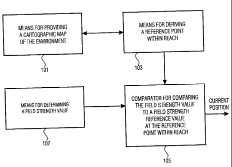
Fig. 1 shows a principle block diagram of an inventive
apparatus for determining a current position of a mobile
device in an environment in which at least one transmitter,
for example a base station, is arranged. The apparatus
CA 02574794 2011-06-07
- 5 -
includes means 101 for providing a cartographic map of the
environment, which illustratively includes field strength
reference values at reference points of the environment.
Means 101 for providing the cartographic map of the
environment is coupled to means 103 for deriving a reference
point within reach, which can be reached starting from a
previous position, which for example has been determined at a
previous point in time, by movement of the mobile device in
the environment within a predetermined time interval. Means
103 for deriving the reference point within reach is coupled
to a comparator 105 for comparing a field strength value with
a field strength reference value at the reference point
within reach. The field strength value is a field strength
value at the current position of the mobile device. In order
to determine this field strength value, the apparatus shown
in Fig. 1 further includes means 107 for determining a field
strength value, which is coupled to the comparator 105.
Illustratively, means 107 for determining the field strength
value is formed to measure the field strength value at a
current position at which the mobile device momentarily is.
To this end, means 107 for determining the field strength
value may for example include a field strength sensor.
According to a further embodiment, means 107 for determining
the field strength value includes a receiver formed to
receive the electromagnetic waves radiated from the
transmitter set up in the environment or from a plurality of
transmitters set up in the environment, and to determine the
field strength values on the basis of the received waves.
According to a further embodiment of the present invention,
means 107 is formed to measure the field strength values in
regular measurement intervals. For example, means 107 for
determining the field strength value is formed to measure the
field strength values at regular points in time defining the
measurement intervals, with a temporal spacing between two
measurement time instants being one millisecond, for example.
CA 02574794 2011-06-07
- 6 -
Furthermore, means 107 for determining the field strength
value can be formed to determine the field strength reference
values required for the position determination for example
during a learning phase. To this end, means 107 for
determining may be formed to determine a field strength-
reference value by averaging among a currently measured field
strength value and a mean value of measured field strength
values determined at an earlier point in time.
In order to update the cartographic map of the environment
with respect to the field strength reference values, means
101 for providing the cartographic map of the environment may
be formed to enter one or more field strength reference
values that have been determined by means 107 for determining
the field strength value into the cartographic map of the
environment at the accompanying reference points, wherein a
reference point may for example be localized by indication of
its three-dimensional coordinates (x, y, z), for example in
meters, in the environment.
Means 103 for deriving the reference point within reach may
illustratively be formed to derive the reference point within
reach from the cartographic map of the environment. The
predetermined time interval may for example be a time
interval between two successive measurement procedures
performed by means 107 for determining the field strength
value. The time interval may for example range from one to 10
ms.
According to a further embodiment of the present invention,
means 107 for deriving the reference point within reach is
formed to determine the reference point within reach on the
basis of a calculation of a shortest path between a previous
position of the mobile device and a plurality of reference
points within reach from the previous position by movement of
the mobile device.
CA 02574794 2011-06-07
7 -
For example, means 103 is formed to establish a routing map
including all possible connections between reference points
in the environment that are within reach by movement of the
mobile device. For example, means 107 for deriving is formed
to calculate a shortest connection between a first reference
point and a second reference point, which then represents a
possible connection, wherein graph-theoretical algorithms may
be employed to this end, for example.
According to a further embodiment of the present invention,
means 103 for deriving is formed to determine the above-
mentioned routing map using a routing algorithm, for example
the Dijkstra algorithm.
The comparator 105 illustrated in Fig. 1 is illustratively formed
to determine the current position of the mobile device on the
basis of a comparison of the captured field strength value at
the current position with illustratively a plurality of field
strength reference values at various reference points that
can be. reached from the previous position, wherein the
current position corresponds to the reference point in the
environment that is associated with a field strength
reference value having a smallest difference with respect to
the currently captured field strength value. In other words,
the comparator 105 is formed to compare the field strength
value with the field strength reference value at the
reference point within reach and with a further field
strength reference value at a further reference point that
can be reached from the previous position, and to determine,
as the current position, a reference point associated with a
field strength reference value most closely corresponding to
the field strength value.
According to a further aspect of the present invention, the
comparator 105 may be formed to determine the reference point
within reach as the current position if the field strength
reference value matches the field strength value currently
captured within a predetermined value interval. The
CA 02574794 2011-06-07
- 8 -
predetermined value interval may be a relative field strength
reference value-related interval including values between
0.51 and 1, for example.
According to a further aspect of the present invention, a
position algorithm using location-dependent reference data
(physical model), for example, acquired in a learning phase
is employed for position determination. The positioning is
based on the comparison of current measurement data according
to the reference data. A description of the environment, for
example in form of the cartographic map of the environment
already mentioned, which is a logical model as opposed to the
physical model, enables recognizing possible directions of
movement and excluding impossible ones, for example a
movement through a wall.
The core of the position algorithm may be a modeling of the
environment by models, for example. Here, the starting point
is a geographic environment description, for example in form
of a construction plan. Furthermore, the geographic
environment description may include information on the
location of rooms, walls, passages (doors, stairs), and
superstructural conditions. Usually, this data is present as
a paper plan or CAD file from the planning of the building.
The environment models can be derived from this plan.
In Fig. 2, a block diagram for performing positioning from a geographic
environment description is illustrated. The
geographic environment description, for example in form of
the cartographic map of the environment already mentioned,
consists of a physical model, which includes reference
points, for example, and of a logical model, which includes
routing points or neighborhood lists, for example. The
physical model provides a radio-technology characteristic,
whereas movement possibilities can be derived from the
logical model. On the basis of the radio-technology
characteristic and the movement possibilities, the
positioning can be performed.
CA 02574794 2007-01-22
- 9 -
For example, the physical model contains the propagation
characteristic of the signals of all transmitters, for
example all radio base stations set up in the environment. It
consists of an amount of reference points at which the field
strength of all stations that can be received there is known.
The physical model may for example be acquired by explicitly
gathering the data in a learning phase. Albeit intensive,
this method provides very exact results.
The logical model makes it possible to quickly and
efficiently decide whether a movement between two points in
direct way is admissible and what the shortest real path
between two points of the environment, for example between
two reference points, looks like. It consists of previously
calculated routing information. For the buildup of the
logical model, rooms and connections between rooms (doors,
passages etc.) are extracted from the geographic environment
description. Thereby, a graph of rooms develops. Wherever
there are connections in the graph, a direct transition is
possible. For example, the graph provides the basis for a
rough path calculation between points in different rooms. The
rough path calculation provides a sequence of rooms from the
starting room to the target room. To this end, as already
mentioned, routing algorithms, for example the A* algorithm,
can be employed. The A* algorithm is a variant of the widely
known algorithm of Dijkstra optimized for path finding.
For the fine calculation of the path (path finding within
rooms or from a point in a room to the door), according to a
further aspect of the present invention, an amount of points
(routing points) is defined in each room. Each reference
point in the physical model is a routing point in the logical
model at the same time. Points at the room transitions (e.g.
midpoint of a door) may also be defined as routing points.
Between the routing points of a room, the respective shortest
path courses are pre-calculated, wherein also a potentially
adapted form of the A* routing algorithm may be employed, so
that a direct connection, for example as the crow flies, is
CA 02574794 2007-01-22
- 10 -
not possible. By the combination with the above-described
rough calculation, the shortest real path can now efficiently
be calculated between all reference points of the physical
model.
According to a further aspect of the present invention, the
logical model may additionally include a neighborhood list
associating a set of neighbor routing points with each
routing point. The maximum distance of a real path is
configurable and depends on the expected maximum velocity of
the mobile terminals. The neighborhood list is acquired in
the buildup of the model from the above routing information.
As already mentioned, the reference data may be acquired in a
learning phase. For example, the reference data are captured
at various positions within the building in the learning
phase. For a learned routing point, for example its position
(x, y and z) in real coordinates, for example meters, such as
a list of radio base stations heard at this point with their
mean field strength, their standard deviation and the
reception frequency (for example in percent) are stored. The
learning method is automated in the respect that the user can
move to any points within the building and, by a click on the
room plan, gives the system the current position and thus
triggers the learning process. The system then periodically
performs a scan operation with the radio network map. In
this, all base stations within the reception area are
detected and captured with their momentary reception field
strength.
The scan operation is performed so often until the provided
results are stable, which means until the mean value of the
measured values of each individual base station only changes
by less than a configurable threshold value. By mean value,
an averaging method robust against outliers and similar to
the median in result, but quicker to calculate (so-called
robust mean value) is understood. In addition to the field
strength value, it may be recorded, how often each base
CA 02574794 2011-06-07
- 11 -
station has been measured. If recording errors arise during
the measurement value capture or if no stable mean value
arises even after a configurable maximum number of
measurements, e.g. because the user keeps walking during the
measurements instead of staying at the measurement point, the
measurement is cancelled and the user is informed thereof.
The acquired information (coordinates as well as list of base
stations with means field strength, standard deviation and
reception frequency) are filed in a database as part of the
physical environment model, to mention only one among many
possibilities of data storage. Following completion, the user
is informed and may then move to a new point.
Current measurement values (a list of base stations currently
in the reception .area together with the accompanying field
strength values) are determined from the radio map, for
example, at regular intervals for the position determination.
These values may be post-processed by a configurable filter,
and thereby wrong measurements are minimized, and the
reliability of the method is increased. The filter may for
example be a weighted averaging between the newly measured
value of a base station and the last mean value stored in the
filter. For example, the method already mentioned (robust
mean value) is employed for averaging. Illustratively, no further
(e.g. statistical) methods for rendering the raw data are
employed. After this phase, a list of base stations with
smoothed field strength values is available.
Due to the last calculated geographic position, then a
selection of routing points (candidate points) is made, which
are eligible for new position. For example, this is done in
two steps. At first, the next routing point to the last
calculated position (previous position) is determined. Then,
the above-mentioned neighborhood list of the logical model is
used, in which the possible routing points may be looked up.
In this manner, the logical model excludes the routing points
CA 02574794 2011-06-07
- 12 -
that are indeed geographically close, but can really only be
reached by a detour.
By comparing of the current measurement values with the
stored ones, a most probable new routing point, which is
eligible for a potential current position, is determined from
the routing points. For example, the differences of the
measurement values (field strength information), the
reception frequency determined in the learning phase, the
relative strength of the signals of different stations
(ordering of the stations according to field strength), as
well as references between currently received stations and
stations at the routing points, go into the comparison. The
most probable routing point in these aspects is fed into a
prediction unit. From the criteria mentioned, a quality value
providing an indication on how well the set of current
measurement values fits on this routing point is additionally
calculated from the criteria mentioned.
The position prediction unit for example calculates a new
position from the last position and the position of the most
probable routing point with the aid of the routing
information of the logical model. With this, it can be seen
that the path between old and new position may perhaps not be
covered in direct way, since passage is possible only through
a door at a distance of one meter, for example. The position
prediction unit therefore calculates a position on the path
possible on the basis of the logical environment model from
the old position to the most probable routing point. This
position goes into the next iteration of the calculation as
current position.
Fig. 3 illustrates a structure of the method for
determining a current position according to a further
embodiment of the present invention.
At first, in step 301, measurement value capture takes place,
for example a measurement of the field strength. In a further
CA 02574794 2011-06-07
- 13 -
step 303, the measurement values are rendered, wherein
filtering is performed, as already mentioned. Then, in step
305, candidate selection takes place, as well as subsequent
measurement value candidate comparison in step 307. On the
basis of the.measurement value candidate comnparison, path
calculation is performed in step 309.
According to a further aspect of the present invention, the
positioning algorithm may be adapted to the special
conditions by a multiplicity of configuration parameters. For
example, the parameters determine at which frequency the data
capture and recalculation of the position is to take place,
or which maximum velocity of the mobile terminal may be
assumed. For example, the algorithm consists of a set of
meshing sub-algorithms present in various variants (e.g.
optimized for a trade fair environment or office
environment). A currently optimum set of sub-algorithms may
be linked to an adapted overall system via the configuration
parameters.
Embodiments of the present invention may for example be employed within a
cellular radio system (e.g. WLAN or DECT) with at least one
base station, with the radio system enabling unique
identification of a base station.
The system may for example include a receiver
system for the capture of the base station identification and
for the capture of the signal parameters, e.g. reception
field strength, RSSI (radio signal strength indicator) data
capture of all signals of the individual base stations that
can be received at one point in time. The receiver system may
for example be mobile or fixedly built-in, e.g. PDA, mobile
phone, belt device, notebook, watch, extension box, etc.
The system may further include a processing unit
for performing the positioning algorithms, an environment
model for the description of the environment, a database with
CA 02574794 2011-06-07
14 -
reference values of the signal parameters measured in the
environment, etc.
The system may further include configuration parameters for
the adaptation of the positioning algorithms to various
environmental conditions or prediction models. Moreover,
post-processing for rendering the position data, e.g.
interpolation of intermediate values, averaging, etc., may
optionally be provided.
Fig. 4 illustrates the method for determining the
current position according to a further embodiment of the
present invention.
The data acquisition takes place on the device for which the
position is to be determined. All further processing units
may be distributed, which means that the method is
supplemented with a unit for the transmission of the capture
data, the intermediate results or the calculated position
data, with the aim of further processing in an extended
network with distributed processing units or in a central
unit.
According to a further aspect of the present invention, for
example, in the learning phase reference measurements of the
signal parameters are made at points of the target
environment, e.g. possible locations. These are rendered and
stored in a database. According to a further embodiment, the
properties and conditions, such as walls, type, doors,
impossible areas, stairs, etc., are described in an
environment model preferably in a coordinate system. Thus, a
logical and physical description of the environment results.
The configuration parameters contain information on the
control of the algorithms, such as maximum velocities of the
mobile terminals, weighting factors, etc. Profiles for
certain target applications are possible, which are
characterized by a set of configuration parameters.
CA 02574794 2011-06-07
15 -
For the position calculation, current signal parameters are
captured, processed and handed over to the position algorithm
as raw data. This determines the most probable location with
the aid of the reference measurements, the environment
description and the configuration parameters.
By including the environment modeling, an increase in
accuracy is expected to be achieved, because the environment
modeling on its own excludes impossible paths, such as going
through a wall.
According to a further aspect of the present invention, there is provided
a positioning system with an apparatus for determining the
current position, as it is described above. For example, the
system includes one or more antennas to receive the signals
of the transmitters (baseband stations). The system may for
example be constituted by a mobile device, e.g. a mobile
phone, and the apparatus for determining the current
position. The positioning system may further include all
functionalities described above in arbitrary combination.
According to a further aspect of the present invention, the
system may, however, be stationary and may centrally evaluate
the signals detected from a plurality of antennas set up in
the rooms, in order to establish the cartographic map of the
environment described, for example.
According to -a further aspect of the present invention,
several antennas may be used in an inventive positioning
system, in order to achieve more accurate and reliable
determination of the RSSI values due to the antenna diversity
achieved therewith.
According to a further aspect of the present invention, a
compass may be used for improving the spatial orientation of
the user, i.e. the mobile terminal. In this case, the
apparatus for determining the current position
includes a compass, for example.
CA 02574794 2011-06-07
- 17 -
Besides the expected advantages already described, embodiments of the
inventive
positioning system may also be realized in purely passive
fashion depending on the radio system used, which means that
no subscription, logon or the like to the network is
necessary. Thereby, existing systems, in particular, such as
WLAN networks or DECT telephone facilities in office
buildings, airports, etc., may be used without technical
extension. Mobile systems with position determination may
simply be introduced into the system and operated without
administration of the network or the telephone facility.
Furthermore, no disturbing influences on the functionality
and availability of the radio system arise by the passive
behavior.
Moreover, embodiments of the inventive system are universally adaptable to
new environments or dynamically reloadable on location by its
parameterizability, in which the following parameters are
used, for example: channel models, base station information,
environment information.
According to a further embodiment of the present invention, a
personal digital assistant (PDA) may be extended with a WLAN
PCMCIA plug-in card. Thereby, unique MAC addresses of the
base stations and the accompanying reception field strength
can be determined.
A driver software contains all further above-described
components and makes the position data available to a
visualization surface upon request. The driver software uses
information on the base stations, the environment and further
configuration data as input parameters. With such systems, a
guidance or information system may then be realized, for
example.
According to a further aspect of the present invention, embodiments of the
inventive apparatus for determining the current position illustratively
include
a screen formed to display the determined current position in the
environment.
CA 02574794 2011-06-07
-18-
Depending on the circumstances, embodiments of the inventive
methods may be implemented in hardware or in software. The
implementation may be effected on a digital storage medium, for
example a floppy disk or CD with electronically readable control
signals, which may cooperate with a programmable computer system,
such that the corresponding method is executed. Thus, embodiments
of the present invention generally also consist of a computer
program product having a program code, stored on a machine-readable
carrier, for performing the corresponding embodiments of the
inventive method, when the computer program product is executed on
a computer. In other words, embodiments of the present invention
may thus also be realized as a computer program code for performing
at least one method, when the computer program is executed on a
computer.