Note: Descriptions are shown in the official language in which they were submitted.
CA 02576847 2007-02-05
Storage and Visualising Points of Interest in a Navigation System
Field of Invention
The present invention relates to route guidance by a navigation system and a
navigation
system for a vehicle. In particular, it relates to route guidance including
the presentation of
points of interest along the route.
Prior Art
Nowadays navigation systems have become standard equipment for upper class
vehicles.
Usually such systems receive GPS (Global Positioning System) - satellite radio
signals.
These radio signals are received by a GPS antenna of the vehicle and are
provided to a
navigation computer in the vehicle. This computer processes the received data
and
furthermore data obtained by motion sensors, as wheel sensors and gyroscopes,
and thus,
determines the present position of the vehicle.
Known navigation systems typically use electronic maps to represent
cartographic features,
as streets, buildings and rivers, and make use of a medium such as a compact
disk or a
digital video disc to store the data that relates to the cartographic
features. After map
matching the present position of the user is indicated in the digital map. By
acoustic and/or
visualized information the user is guided to the predetermined destination.
Some navigation systems are able to display detailed digital maps and/or three-
dimensional
detailed views indicating routes to predetermined destinations, the types of
maneuvers to be
taken at various locations as junctions as well as different kinds of points
of interest (POI)
as, for example, gas stations, hotels or restaurants and also landmarks.
In order to provide the navigation functions, navigation systems make use of
one or more
detailed databases that may comprise bitmap images for lanes, sign post
information,
CA 02576847 2007-02-05
EP41005UW0041ca 2 P06004
Grunecker, Kinkeldey, Stockmair Harman Becker
& Schwanhausser - Anwaltssozietat
landmarks etc. and data which, e.g., represent physical features of a
geographic region and
points of interest.
However, by present navigation systems, the driver is provided with
standardized non-
individual information only. For particular navigation systems, particular
software is available
designed for the majority of users. This software cannot be manipulated by the
users and,
therefore, cannot be adapted to the individual needs of the users. There is,
thus, some need
for navigation systems that can be individually customized. The acceptance of
navigation
systems and the comfort of using them could thereby significantly be improved.
It is therefore a problem underlying the present invention to provide a
navigation system
providing route guidance that can be adapted to the needs and preferences of
an individual
user.
Description of the Invention
The above-mentioned problem is solved by a navigation system of claim 1,
comprising a
location means configured to determine an actual position, i.e. a position at
which the
navigation system is presently located, a database and an input means
configured to store
the actual position determined by the location means and also at least one
class of points of
interest and/or at least one point of interest related to the stored actual
position in the
database. The navigation system further comprises an output means configured
to output
the stored actual position and/or the stored at least one class of points of
interest and/or at
least one point of interest related to the stored actual position.
The actual position can be stored by storing coordinates (geographic or
arbitrary relative
coordinates of a digital map, e.g.) of the actual position. The at least one
class of points of
interest and/or at least one point of interest may be related to the stored
actual position in
that is located at the stored actual position.
CA 02576847 2007-02-05
3
EP41005UW0041ca P06004
Grunecker, Kinkeldey, Stockmair Harman Becker
& Schwanhausser - Anwaltssozietat
The navigation system may be a handheld one or, preferably, a navigation
system installed
in a vehicle, as an automobile, motorcycle, ship, airplane. The database may
be a database
already including part or all of the data used for route guidance and
configured so that it can
be updated, e.g., after being purchased by a user. Alternatively, the database
can be a
supplementary database that can be used together with a database including
sufficient data
to perform route guidance. Both kinds of databases can physically be carried
by magnetic or
optical storage media.
The output means may output the stored actual position and the stored at least
one class of
points of interest and/or at least one point of interest related to the actual
position according
to the stored coordinates in different ways, e.g., by displaying a symbol for
a (class of a POI)
at the appropriate position in a digital map (see also discussion below). The
stored actual
position may be output by means of an indication of relative distance of a
second position to
the stored actual position. The second position may be a present position of a
vehicle that
travels a route already traveled before in a first travel during which the
actual position was
stored. The stored actual position and/or the stored at least one class of
points of interest
and/or at least one point of interest related to the stored actual position
may be output during
route guidance or route planning before the route to a selected destination is
calculated
and/or indicated.
Due to the input means the database can be updated by actual positions
determined by the
location means and by relating a class of points of interest and/or a point of
interest to the
actual position. Examples for classes of points of interest are hotels,
restaurants, service
stations, police stations, etc. Points of interest may belong to a defined
class. However, it
might be possible to store a newly defined point of interest that presently
does not belong to
any pre-defined class. The user also may be enabled to define a new class of
POls. For
example, a user may define a class of POls representing a particular kind of
stores. The
symbol indicating stores may be designed by the user himself. Thus, a user can
adapt by
and by a navigation system according to his individual needs and preferences.
CA 02576847 2007-02-05
EP41005UW0041ca 4 P06004
Grunecker, Kinkeldey, Stockmair Harman Becker
& Schwanhausser - Anwaltssozietat
If installed in a vehicle, input means of the claimed navigation system can be
operated by a
driver or another user. In general, the input means may comprise a haptic or
acoustic input
means configured to enable a user to initiate storing of (the coordinates of)
the actual
position and/or to select at least one class of points of interest and/or at
least one point of
interest related to the actual position. Here, selection of a class of points
of interest and/or at
least one point of interest related to the actual position implies assignment
of data
representing the actual position, coordinate data, and data representing at
least one class of
points of interest and/or at least one point of interest.
If during the travel the driver, e.g., realizes something that might be of
interest when the
same route will at least partly be traveled again in the future, he can
initiate that the input
means stores the present position that is determined by the location means
included in the
navigation system in the database. The driver/user also may operate the input
means, e.g.,
by a switch or cursor or by voice input, to assign a class of POIs, e.g.,
hotels, restaurants,
service stations, to the determined and stored actual position. After the
travel the driver may
specify the assigned class and may, e.g., type-in by means of a keyboard
connected to the
navigation system a text giving details for the chosen class of POls. Thereby,
information as,
e.g., "Restaurant" (Class of POI) - the coordinates of the service station in
a digital map
(actual position) and "Italian Restaurant; Probably Upmarket" (POI specified
with individual
text) may be stored in the database.
The navigation system of the present invention may comprise an speech
recognition means
that is configured to detect a speech input and to cause the input means to
store the
coordinates of the actual position and at least one class of points of
interest and/or at least
one point of interest related to the actual position in the database, if a
particular speech input
is detected. The particular speech input can be a predefined watchword. The
watchword can
be pre-defined and recorded by a user, in particular, may be a watchword
spoken and
recorded by a user.
CA 02576847 2007-02-05
EP41005UW0041ca P06004
Grunecker, Kinkeldey, Stockmair Harman Becker
& Schwanhausser - Anwaltssozietat
If, e.g., a driver utters "Store Hotel", the system may be configured such
that the actual
position and 'hotels' as the class of POIs related to the actual position are
stored in the
database. 'Hotels' as the class of POls may be stored related to the actual
position by
generating a link from the data representing the coordinates of the actual
position and data
5 representing the above-mentioned class. The speech recognition system may be
activated
by a push-to-talk lever.
The output means included in the disclosed navigation system can be configured
to output
the stored actual position and the stored at least one class of points of
interest and/or at
least one point of interest related to the actual position by displaying a
symbol for a class of
points of interest or of a point of interest in a digital map at a position
given by the stored
coordinates. The symbol can be easily recognized by a user inspecting the
digital map. The
symbol may be displayed highlighted or even as a blinking symbol.
According to one embodiment the claimed navigation system may comprise a
symbol
database that is configured to store symbols for classes of POls and symbols
for POIs and
the database may be a separate one or part of the same database as mentioned
above. In
particular, the symbol database may be configured to be amended by a user. The
user may,
e.g., assign text to a symbol representing, e.g., a restaurant. On the other
hand, a symbol
itself may be a text consisting of letters.
Symbols may also comprise digital photographs or bitmaps or vector graphics.
Whereas bit-
mapped images consist of rows and columns of dots, vector graphics are
represented as
mathematical formulas that define all the shapes in an image. Vector graphics
are based on
mathematical functions and they are scalable, not restricted to rectangular
shapes and
transparent. Moreover, vector graphics require less disk space than bitmaps,
since they can
be calculated from relatively few data points that have to be stored. Thus,
vector graphics
can particularly suitably be used for calculating and displaying 3-dimensional
symbols.
CA 02576847 2007-02-05
EP41005UW0041ca 6 P06004
Grunecker, Kinkeldey, Stockmair Harman Becker
& Schwanhausser - Anwaltssozietat
It is preferred that the inventive system may provide the possibility that new
symbols may be
added to the symbol database and that previously stored symbols can be deleted
or
modified. Thus, the claimed navigation system may comprise a symbol database
storing at
least one symbol for at least one class of points of interest and/or at least
one point of
interest and configured to be amended by insertion of a new symbol and
deletion/modification of a stored symbol and wherein the output means is
configured to
output the stored at least one class of points of interest and/or at least one
point of interest
by means of the least one symbol stored in the symbol database.
Such new symbols may be created by a user himself or obtained from a provider.
It is
envisaged that new symbols may be downloaded, e.g., via the Internet, by the
user and
subsequently stored in the symbol database of the inventive navigation system.
The output means may comprise an acoustic output, preferably, a speech output,
and can
be configured to output a message, preferably a verbal message previously
recorded by a
user, concerning the POI (or class of POIs) related to the position and
optionally concerning
the stored position itself. In particular, the verbal message may be spoken
and recorded by
a user.
In a specific example, when the driver travels again a route he previously had
traveled, a
message may be given in form of the verbal announcement "Italian restaurant -
200 meters -
on the right", if the driver has adapted the used navigation system in
accordance with the
present invention. In this case, the stored actual position is output by the
output means in
form of the verbal message "200 meters - on the right" making use of both the
present
position during the second travel and the (previously actual) position stored
during the first
travel. Thus, the output means may be configured to output information
containing the
stored information but also on the basis of a new present position when
traveling an already
traveled route. In the above example the input means might have been used to
store the
output message, e.g., the user has uttered the message to be announced and the
utterance
CA 02576847 2007-02-05
7
EP41005UW0041ca P06004
Grunecker, Kinkeldey, Stockmair Harman Becker
& Schwanhausser - Anwaltssozietat
was detected by a voice input means. Thereby, an individually customized
message can be
output.
The output means included in the navigation system according to the present
invention may
be configured to output the stored actual position and/or the stored at least
one class of
points of interest and/or at least one point of interest related to the stored
actual position,
only if the navigation system is within a predetermined distance from the
stored actual
position. The navigation system, thus, may comprise a means to determine the
distance
from the present position to the stored actual position. At the time of
storage of actual
position, the present position of the vehicle is substantially the same
position as the stored
actual position.
Consider a case in which a route is traveled for the first time. At an actual
position the user
initiates that the coordinates of actual position and, e.g., a POI related to
this position are
stored in the database. The concept for assigning the coordinates, that may be
any kind of
suitable coordinates, and the POI may be any concept known in the art to
relate different
kinds of data to each other including the usage of pointers and/or multi-
dimensional arrays.
Links from entries of a predefined or user-defined library, as symbols, to a
library containing
stored positional data (coordinates) may be defined and managed. When
subsequently the
route is traveled at least partly once again, at a predetermined distance
only, which might be
chosen by the user, the POI and the position of the POI are indicated to the
user, e.g_, by
means of displaying or acoustically announcing a corresponding message or by
displaying
the corresponding symbol at the respective place in a digital map displayed to
the user.
According to another embodiment the input means of the inventive navigation
system can
be configured to store an arbitrary position, in particular, the coordinates
of an arbitrary
position, and at least one class of points of interest and/or at least one
point of interest
related to the arbitrary position in the database and the output means of the
inventive
navigation system can be configured to output the stored arbitrary position
and the stored at
CA 02576847 2007-02-05
EP41005UW0041ca 8 P06004
Grunecker, Kinkeldey, Stockmair Harman Becker
& Schwanhausser - Anwaltssozietat
least one class of points of interest and/or at least one point of interest
related to the stored
arbitrary position.
Accordingly, the user is not restricted to customize the navigation system on
a
present/actual position basis but may also initiate storing of the coordinates
of an arbitrary
position and at least one class of points of interest and/or at least one
point of interest
related to the arbitrary position at any time. The user may, e.g., select a
symbol by means of
a cursor means and drag-and-drop it to a desired position in a digital map.
In order to solve the above mentioned problem, the present invention also
provides a
method for route guidance, comprising the steps: indicating a route to a
predetermined
destination, indicating at least one stored class of points of interest and/or
at least one
stored point of interest wherein the at least one class of points of interest
and/or the at least
one point of interest have been stored at least one position of the route
during a previous
travel along the route or for a position, e.g., after or during a previous
travel. The class of
POls or the POI has been stored together with coordinates of the respective
position.
Coordinates may be geographic or arbitrary coordinates.
The at least one stored position can, in particular, be an actual position of
a vehicle during
the previous travel, i.e. a present position of the vehicle at a given time.
However, a POI or a
class of POls can also be stored for an arbitrary position, in particular,
along the route.
Indication of the route as well as the at least one class of points of
interest and/or the at
least one point of interest can be performed acoustically and/or visually by
means of a digital
map or some graphic representation of the route, in general.
Thus, the inventive method may comprise two stages, in principle:
1) Basically conventional route guidance during a travel of a route at a first
time during
which, however, POIs along the route are introduced by a user on demand by
storing an
CA 02576847 2007-02-05
EP41005UW0041ca 9 P06004
Grunecker, Kinkeldey, Stockmair Harman Becker
& Schwanhausser - Anwaltssozietat
actual position and assigning a POI, e.g. represented by a symbol to be
displayed in a digital
map, to this actual position.
2) Route guidance at least partly along the same route at a second time and
indicating the
previously stored class of POIs or POIs, e.g., by displaying them in a digital
map or by
verbal announcing approach of a POI by means of a speech output. Besides
indicating the
(class of) POI, the stored position may be implicitly (by simply positioning a
symbol at the
correct place in a digital map, for example) or expressly (by indicating
relative or absolute
distances and/or positions) indicated.
Consequently, the route guidance can be adapted to the individual needs and
preferences
of a user. Not only the comfort is improved but also traveling safety might be
enhanced. For
example, the beginning of a tempo limit zone can be indicated by means of an
appropriately
chosen or defined POI symbol. The symbol may be plain text.
The at least one class of points of interest and/or the at least one point of
interest can be
indicated by displaying symbols in a digital map or by announcing a an
acoustic or verbal
message. The displayed symbols may comprise plain text and may be generated or
otherwise provided by a user. The symbols may comprise bitmaps, vector
graphics or digital
photographs or any combination thereof. If, in particular, symbols are used
that are
individually designed by a user the "look and feel" quality of the guidance
method is greatly
enhanced. The announcement is preferably performed acoustically but,
alternatively, a
readable text may be displayed to the user. A message previously recorded by a
user may
be announced.
In the above described examples for the guidance method the at least one class
of points of
interest and/or the at least one point of interest can be defined by a user.
Thereby, the user
is given even more freedom to customize the navigation aid by, e.g., defining
a new class of
POls representing the domiciles of relatives.
CA 02576847 2007-02-05
EP41005UW0041ca 10 P06004
Grunecker, Kinkeldey, Stockmair Harman Becker
& Schwanhausser - Anwattssozietat
According to another aspect the method for route guidance comprises indicating
the at least
one class of points of interest and/or the at least one point of interest, in
particular, along the
route, only if the at least one class of points of interest and/or at least
one point of interest
stored at or for at least one position of a route lies within a predetermined
distance of a
present position of the employed navigation system during a travel under route
guidance.
The present invention also provides a computer program product, comprising one
or more
computer readable media having computer-executable instructions for performing
the steps
of the method described above, in particular, the indicating of the POls.
Additional features and advantages of the present invention will be described
with reference
to the drawings. In the description, reference is made to the accompanying
figures that are
meant to illustrate preferred embodiments of the invention. It is understood
that such
embodiments do not represent the full scope of the invention.
Figure 1 shows a flow chart illustrating the process of route guidance
according to an
example of the present invention including storing an actual position of a
vehicle and a
related POI at a first travel along a route and announcing a message referring
to the POI
when traveling the route a second time.
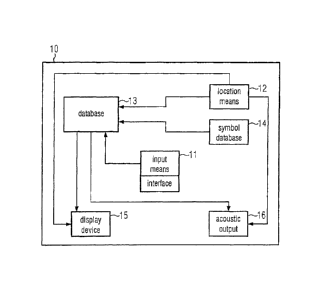
Figure 2 shows components of an example for the inventive navigation system
comprising a
database for storing actual positions and related thereto points of interest
as well as a
symbol database for storing symbols indicating points of interest.
Figure 3 illustrates a detailed example for the route guidance including the
individually
customized verbal announcements of points of interest.
Figure 1 illustrates route guidance according to an example of the present
invention. The of
a vehicle travels along a route guided by a navigation system 1. During the
travel the driver
enters a speed limit zone that begins immediately behind a corner. The driver
immediately
CA 02576847 2007-02-05
11
EP41005UW0041ca P06004
Grunecker, Kinkeldey, Stockmair Harman Becker
& Schwanhausser - Anwaltssozietat
pushes a position storage button to store the actual position 2 as determined
by a location
means that forms a part of the navigation system. Subsequently, symbols are
shown on a
display of the navigation system 3 that represent classes of points of
interest (POls) as, e.g.,
service stations, hotels, etc. There is also a blank class entitled "New
class". Since the driver
cannot find a symbol indicating a speed limit zone, he selects 4 the displayed
blank class,
e.g., by means of a cursor or a touch screen button.
At the next red traffic light the driver has ample time to type a text as a
symbol for the new
class to be defined 5: "speed limit zone". Alternatively, the driver could
have been presented
a number of symbols not yet displayed in a step 3. In this case, the driver
would choose one
of the presented symbols considered to be appropriate. In a database of the
navigation
system data representing the actual position and related thereto data
representing the new
symbol for the newly introduced class of POls are stored 6.
The next time the driver travels the same route as at the first time route
guidance is again
carried out 7. The route to be taken is displayed in a digital map. Different
from the display
during the previous route guidance, this time at the position corresponding to
the stored
actual position, i.e. the coordinates, of the beginning of the speed limit
zone, the symbol for
the class of POls "speed limit zone" that was newly generated 5 at the first
travel is
displayed 8, e.g. the text "speed limit zone". Thereby, the driver can
realize/remember that
he is approaching a speed limit zone that begins shortly after the respective
curve.
Components of an example of the navigation system disclosed in this
application are
illustrated in Fig. 2. The navigation system 10 comprises an input means 11
that can be
operated by a user and that stores an actual position determined by a location
means 12 on
demand by the user in a database 13. The input means 11 comprises a user
interface that
includes haptic and acoustic input means. By means of the user interface the
user is
enabled to select a symbol stored in a symbol database 14. The symbol or a
link to the
symbol is stored together with and related to the actual position data, i.e.
the coordinates of
the actual position, in the database 13.
CA 02576847 2007-02-05
EP41005UW0041ca 12 P06004
Grunecker, Kinkeldey, Stockmair Harman Becker
& Schwanhausser - Anwaltssozietat
The navigation system 10 also comprises a display device 15 that displays a
digital map
including symbols representing POls at the actual positions at which they are
introduced to
the system by the user. Moreover, a speech output 16 configured to output
synthetic speech
is included in the navigation system 10. In fact, the display device 15 and
the speech output
16 can be controlled to indicate one or more POls stored in the database 12 in
dependence
on the present location of the vehicle that, in general, is different from the
previously stored
actual position.
With reference to Figure 3 an example of the inventive guidance method is
described in the
following in some detail. A driver of an automobile is traveling under route
guidance 21 by a
vehicle navigation system (see also Figure 2). After some time the driver
arrives at an
intersection he presently considers dangerous. He presses a push-to-talk
button and utters
"Store position !" 22. The actual position of the automobile, in form of
appropriate
coordinates, e.g., geographic coordinates or coordinates of the digital map,
as determined
by a location means being part of the navigation system is stored in a
database 23. The
speech recognition system included in the navigation system may output 24
"Position
stored. Point of Interest ?" Alternatively, the driver may be prompted to
input a POI by
means of a keyboard or a cursor usable to select from a list of symbols
representing POls
that is displayed on a display device 24.
The driver utters 25 "Dangerous Intersection". By this utterance a data link
is generated /
stored linking the stored coordinate data to a speech sample in a library used
by the speech
recognition system 26. The speech sample may be "Attention! Dangerous
Intersection!"
Furthermore, a user generated symbol intended to represent dangerous
intersections is
loaded in the database in which the coordinates are stored and linked 27 to
the data
representing these coordinates. Alternatively, a data link is generated /
stored linking the
stored coordinate data to the user generated symbol that is stored in a
separate symbol
database 27. The symbol may be previously generated by the user, e.g., from a
digital
photograph or by modification of a downloaded vector graphic.
CA 02576847 2007-02-05
EP41005UW0041ca 13 P06004
Grunecker, Kinkeldey, Stockmair Harman Becker
& Schwanhausser - Anwaltssozietat
Now assume that the driver is traveling along the same route at a latter time
again guided by
the navigation system 28. When he approaches the above mentioned intersection
within a
predetermined distance 29, the speech recognition system is activated and a
synthetic
speech output is made 30: "Attention! Dangerous Intersection!"
With the help of a location means included in the navigation system the actual
distance to
the position stored for the above mentioned POI in step 22, i.e. the
intersection, can
continuously be determined during the travel. When a predetermined distance,
which may
be pre-selected by the driver, is reached, the warning announcement is made
30. It may
also be preferred that the distance is announced to the driver, e.g.,
"Attention! Dangerous
Intersection! 100 meters". The speech recognition system may be configured
such that a
speech sample can be recorded from an utterance by the driver himself and then
stored for
a subsequent output.
In this example, route guidance is performed acoustically and also visually by
displaying a
digital map including the present position of the vehicle and indicating the
route to be taken.
The digital map includes symbols for classes of POIs and for individual POls.
In particular, in
the given example the digital map includes the symbol individually customized
by the user.
This symbol is shown at the position in the map that corresponds to the
coordinates stored
in step 23. Thus, the driver is informed about the dangerous intersection by
inspection of the
displayed digital map. Moreover, it might be envisioned that the symbol is
blinking when the
automobile reaches the intersection within a predetermined distance.
Whereas the above detailed description relates to vehicle navigation systems
it is obvious
that the present invention may also be incorporated in a handheld navigator.