Note: Descriptions are shown in the official language in which they were submitted.
CA 02577845 2013-07-02
1 METHOD FOR CREATING FACIES PROBABILITY CUBES
2 BASED UPON GEOLOGIC INTERPRETATION
3
4 FIELD OF THE INVENTION
6 The present invention relates generally to methods for constructing
reservoir facies
7 models, and more particularly, to methods for creating facies probability
cubes to be
8 used in geostatistical simulations to create reservoir facies models.
9
11 BACKGROUND OF THE INVENTION
12
13 Reservoir flow simulation typically uses a 3D static model of a
reservoir. This static
14 model includes a 3D stratigraphic grid (S-grid) commonly comprising
millions of cells
wherein each individual cell is populated with properties such as porosity,
16 permeability, and water saturation. Such a model is used first to
estimate the volume
17 and the spatial distribution of hydrocarbons in place. The reservoir
model is then
18 processed through a flow simulator to predict oil and gas recovery and
to assist in
19 well path planning.
21
- 1 -
CA 02577845 2007-02-19
WO 2006/033726 PCT/US2005/029318
In petroleum and groundwater applications, realistic facies modeling, prior to
2 porosity, permeability, and water saturation modeling, is critical to
make realistic
3 flow performance predictions that will enable identifying new resource
4 development opportunities and make appropriate reservoir management
decisions such as new well drilling. Current practice in facies modeling is
6 mostly based on variogram-based simulation techniques. A variogram is a
7 statistical measure of the correlation between two spatial locations in a
8 reservoir. A variogram model is usually inferred from well data.
9
These variogram-based simulation techniques are known to give to a modeler a
11 very limited control on the continuity and the geometry of simulated
facies. The
12 techniques may provide reasonable predictions of the subsurface
architecture
13 in the presence of closely spaced and abundant data, but they usually
fail to
14 adequately model reservoirs with sparse data collected at a limited
number of
wells. This is commonly the case, for example, in deepwater exploration and
16 production where, in general, variogram-based models display much more
17 stochastic heterogeneity than expected from the conceptual depositional
18 models provided by geologists.
19
A more recent modeling approach, referred to as multiple-point statistics
21 simulation, or MPS, has been proposed by Guardiano and Srivastava,
22 Multivariate Geostatistics: Beyond Bivariate Moments: Geostatistics-
Troia, in
23 Soares, A., ed., Geostatistics-Troia: Kluwer, Dordrecht, V. 1, p. 133-
144.
24 (1993). MPS simulation is a reservoir facies modeling technique that
uses
conceptual geological models as 3D training images to generate geologically
26 realistic reservoir models. Reservoir models utilizing MPS methodologies
27 have been quite successful in predicting the likely presence and
28 configurations of facies in reservoir facies models.
29
Numerous others publications have been published regarding MPS and its
31 application. Caers, J. and Zhang, T., 2002, Multiple-point
Geostatistics: A
32 Quantitative Vehicle for Integrating Geologic Analogs into Multiple
Reservoir
-2-
CA 02577845 2007-02-19
WO 2006/033726
PCT/US2005/029318
Models, in Grammer, G.M et al., eds., Integration of Outcrop and Modern
22
-3-
CA 02577845 2007-02-19
WO 2006/033726
PCT/US2005/029318
The aforementioned facies probability cube was created from seismic data
2 using a purely mathematical approach, which is described in greater
detail in
3 a paper to Scheevel, J. R., and Payrazyan, K., entitled Principal
Component
4 Analysis Applied to 3D Seismic Data for Reservoir Property Estimation,
SPE
56734, 1999. Seismic data, in particular seismic amplitudes, are evaluated
6 using Principal Component Analysis (PCA) techniques to produce
7 eigenvectors and eigenvalues. Principal components then are evaluated in
8 an unsupervised cluster analysis. The clusters are correlated with known
9 properties from well data, in particular, interpreted facies, to estimate
properties in cells located away from wells. The facies probability cubes are
11 derived from the clusters.
12
13 Both variogram-based simulations and the MPS simulation utilizing the
14 seismically-derived facies probability cubes share a common shortcoming.
Both simulations methods fail to account for valuable information that can be
16 provided only by geologist/geophysicist's interpretation of the
reservoir's
17 geological setting based upon their knowledge of the depositional
geology of
18 the region being modeled. This information, in conjunction with core and
19 seismic data, can provide important information on the reservoir
architecture
and the spatial distribution of facies in a reservoir model.
21
22 Probability cubes are also known which, rather than being mathematically
23 derived from seismic data, rely primariliy upon geological
interpretation and
24 conceptualization. Examples of commercial facies modeling programs
include
PETREL , ROXAR and HERESIM programs. The PETREL program is
26 available from Technoguide AS Corporation of Oslo, Norway. The ROXAR
27 software is sold by ROXAR ASA Public Limited Company of Stavanger,
28 Norway. The HERESIM program is available from Institut Francais du
Petrole
29 of Cedex, France.
31 These programs typically combine vertical facies trend information with
map or
32 horizontal fades trend informaton to create facies cubes. In some
instances,
-4-
CA 02577845 2007-02-19
WO 2006/033726
PCT/US2005/029318
1 such as with RO)(AR , a modeler inputs equations to describe the
probability of
2 finding facies in a vertical section or else in a horizontal or map
section or 3D of
3 a model. Alternatively, in other commercial programs such as PETREL , a
4 modeler may directly digitize a facies probability map wherein the
modeler
attempts to simultaneously account for the competing presence of all facies in
a
6 single map.
7
8 Making simultaneous estimates of facies locations and probabilities that
are
9 highly dependent upon one, either through digitization or through
estimating
equations, are complex and challenging. Such methods make it difficult to
11 rapidly create numerous probability cubes based on different geologic
12 interpretations and assumptions of how the facies are distributed in a
13 S-grid. Furthermore, algorithms used to combine vertical and map facies
trend
14 information to produce facies probability cubes can produce less than
optimal
estimates of the probabilities. The present invention addresses these
16 shortcomings in making such facies probability cubes.
17
18 SUMMARY OF THE INVENTION
19
A method for creating a facies probability cube is disclosed. First, a S-grid
is
21 created which is representative of a subsurface volume containing
facies.
22 The grid includes layers and columns of cells. Vertical facies
proportion data
23 for the layers of cells are determined from sources such as well data,
24 conceptualizations of geologic vertical cross-sections taken along the S-
grid
and vertical proportion graphs.
26
27 Horizontal or map facies proportion data is then calculated. Boundaries
are
28 defined on an areal "depocenter" map for each of the facies to create
29 depocenter regions in which respective facies are likely to occur within
the
S-grid. Ideally, the boundaries for each of the facies are drawn sequentially
31 and generally independently of one another. Typically, some of the
32 depocenter regions will overlap one another. Horizontal or map facies
-5-
CA 02577845 2007-02-19
WO 2006/033726 PCT/US2005/029318
proportion data for the columns of cells are then determined based on the
2 boundaries of the depocenter regions. The proportion of each facies is
3 smoothed across its associated boundary from a maximum value at a
4 depocenter of a respective facies' depocenter region to a minimum value
located laterally from that depocenter. The depocenter map may also include
6 truncation regions in which particular facies may exist. Conversely, the
7 particular facies may not exist in regions outside the truncation region.
8
9 A transition filter is ideally used to smooth or transition the
horizontal facies
proportion data from a maximum value at a depocenter to a minimum value.
11 The transition filter can be used to define a specific lateral distance
over which
12 the relative likelihood of occurrence of a facies decays to zero away
from a
13 boundary of a depocenter region. Alternatively, a quantitative inversion
of
14 well data may be used to determine optimal parameters which control the
transition filter.
16
17 The vertical and horizontal facies proportion data are then integrated
to create
18 a facies probability cube in which the cells are assigned probabilities
for the
19 occurrence of facies. Ideally, the integration uses a power law
transformation.
Such a transformation allows layers having 0% or 100% vertical proportion for
21 a particular facies to remain, respectively, at 0% 01 100%, after
integration.
22 The transformation allows layers having a vertical proportion between
23 0% and 100% for a particular facies to remain between 0% and 100%.
24
The method for building the facies probability cubes also may account for
26 cases where there are dominant or else a minimal horizontal facies
proportion
27 for a column of cells. A user may define upper and lower thresholds for
these
28 facies proportions. In the event the proportion of a facies falls below
or above
29 the thresholds, the integration of the vertical and horizontal facies
data will
utilize specially developed weighted facies proportion data. This data
31 accounts for the low or high probability of finding a particular facies
in a
32 column of cells.
-6-
CA 02577845 2013-07-02
1 A method for generating horizontal facies proportion data for a S-grid is
also
2 described. This data reflects the areal distribution of facies within the
S-grid. The grid
3 includes layers and columns of cells. Boundaries are defined on an areal
depocenter
4 map to delineate depocenter regions in which respective facies are likely
to occur
within the S-grid. Ideally, these depocenter regions are estimated generally
6 independently of one another to reduce the complexity that is otherwise
incurred
7 when trying to simultaneously account for the presence of all facies in a
S-grid.
8 Horizontal facies proportion data is generated for the columns of cells
based on the
9 defined boundaries of the depocenter regions with the proportion of each
facies
ranging from a maximum value at a depocenter of a respective facies depocenter
11 region to a minimum value located laterally from the depocenter.
Preferably, a
12 transition filter is applied to a depocenter boundary to transition the
facies
13 probabilities from maximum to minimum values.
14
It is an object of an aspect of the present invention to create an areal
depocenter
16 map which reflects the likelihood of the occurrence of facies in a S-
grid wherein the
17 proportion of a facies decreases from a maximum at a depocenter of a
facies
18 depocenter region to a minimum laterally spaced from the depocenter.
19
It is another object of an aspect of to use a transition filter to calculate
horizontal
21 facies proportion data from defined boundaries for depocenter regions
wherein the
22 transition filter can be readily changed so that multiple facies
probabilities cubes can
23 be quickly created and evaluated.
24
It is yet another object of an aspect to utilize a power transformation law in
an
26 integration of vertical and horizontal facies proportion data so that
layers having 0%
27 to 100% vertical proportion of a particular facies will be maintained at
those
28 respective levels even after the integration.
29
It is a further object of an aspect to provide maximum and minimum thresholds
for
31 facies proportions in a column cells wherein special vertical proportion
data sets are
-7-
CA 02577845 2013-07-02
1 used in an integration of vertical and horizontal fades data when the
proportion of a
2 facies falls below or exceeds those thresholds.
3
4 In accordance with another aspect, there is provided a method for
creating a facies
probability cube comprising the steps of: generating a S-grid which is
representative
6 of a subsurface volume containing facies, the grid including layers of
cells and
7 columns of cells; determining vertical facies proportion data for the
layers of cells;
8 defining boundaries on an areal depocenter map to create depocenter
regions in
9 which respective facies are likely to occur within the S-grid;
determining horizontal
facies proportion data for the columns of cells utilizing the boundaries of
the
11 depocenter regions so that the proportion for each facies ranges from a
maximum
12 value at a facies depocenter for each respective depocenter region to a
minimum
13 value located laterally from the fades depocenter; and integrating the
vertical facies
14 proportion data with the horizontal facies proportion data to create a
facies
probability cube in which the cells are assigned probabilities for the
occurrence of
16 facies.
17
18 In accordance with another aspect, there is provided a method for
creating an areal
19 depocenter map for identifying the distribution of facies within a S-
grid comprising:
generating a S-grid which is representative of a subsurface volume containing
facies,
21 the grid including layers of cells and columns of cells; defining
boundaries on an
22 areal depocenter map of the S-grid to create depocenter regions in which
respective
23 facies are likely to occur within the S-grid; and determining horizontal
facies
24 proportion data for the columns of cells based on the defined boundaries
of the
depocenter regions so that the proportion of each facies ranges from a maximum
26 value a depocenter of each respective facies depocenter region to a
minimum value
27 located laterally from that depocenter.
28
29 BRIEF DESCRIPTION OF THE DRAWINGS
31 These and other objects of aspects, features and advantages of the
present
32 invention will be better understood with regard to the following
description, pending
33 claims and
-7a-
CA 02577845 2013-07-02
,
1 accompanying drawings where:
2
3 FIG. 1 is a flowchart describing a preferred workflow for constructing a
reservoir
4 facies model made in accordance with the present invention;
6 FIG. 2 shows how geological interpretation is used to create 3D training
images
7 which are then conditioned to available data to create a multiple-point
geostatistics
8 model;
9
FIGS. 3A-B show respective slices and cross-sections through a 3D training
image
11 illustrating the geometrical characteristics and associations of
estimated facies;
12
13 FIGS. 4A-E, respectively, show a training image and facies geometrical
parameters
14 (map view shape, cross-section shape, dimensions, orientation and
sinuosity) which
are used to produce facies geobodies in the training image;
16
17 FIGS. 5A-C depict relationship/rules between facies that are used to
build the
18 training images;
19
FIGS. 6A-C illustrate vertical and horizontal constraints between facies;
-8-
CA 02577845 2007-02-19
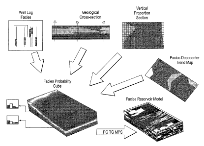
WO 2006/033726 PCT/US2005/029318
1 FIG. 7 is a schematic drawing of a facies distribution modeling technique
used
2 to create a geologically interpreted facies probability cube, and
ultimately, a
3 facies reservoir model;
4
FIGS. 8A-B illustrate a series of facies assigned to a well and a
corresponding
6 facies legend;
7
8 FIGS. 9A-B show an undulating vertical section taken from an S-grid with
9 facies assigned to four wells located on the section and that section
after
being flattened;
11 FIG. 10 shows polygons which are digitized on to a vertical section
which is
12 representative of a modeler's conception of the geologic presence of
facies
13 along that section;
14
FIG. 11 is a vertical proportion graph showing estimates of the proportion of
16 facies along each layer of a vertical section wherein the proportion on
each
17 layer adds up to 100%;
18
19 FIG. 12 shows an exemplary global vertical proportion graph;
21 FIG. 13 illustrates a depocenter trend map containing overlapping facies
22 depocenter regions;
23
24 FIGS. 14A-D show digitized depocenter regions for four different facies
which
suggest where fades are likely to be found in an areal or map view of the
26 S-grid;
27
28 FIGS. 15A-F show the smoothing of a depocenter region into graded
29 probability curves using a pair of boxcar filters;
31 FIGS. 16A-B show dominant and minimal weighting graphs used in creating
32 weighted vertical facies proportion graphs;
-9-
CA 02577845 2007-02-19
WO 2006/033726 PCT/US2005/029318
1 FIG. 17 shows a vertical cross-section of an S-grid used in creating the
2 weighted vertical facies proportion graph; and
3
4 FIG. 18 shows a weighted vertical facies proportion graph.
6 DETAILED DESCRIPTION OF THE INVENTION
7
8 FIG. 1 shows a workflow 100, made in accordance with a preferred
9 embodiment of the present invention, for creating a reservoir facies
model. In
particular, the workflow uses a train ing image, in conjunction with a
11 geologically-interpreted facies probability cube as a soft constraint,
in a
12 geostatistical simulation to create a reservoir facies model.
13
14 A first step 110 in the workflow is to build a S-grid representative of
a
subsurface region to be modeled. The S-grid geometry relates to reservoir
16 stratigraphic correlations. Training images are created in step 120
which
17 reflect the interpreted geometry of each facies and the associations
among
18 facies. A geologically-interpreted facies probability cube is then
created in
19 step 130. This facies probability cu be captures information regarding
the
absolute spatial distribution of facies in the S-grid based upon geologic
21 depositional information and conceptualizations. The facies probability
cube
22 ideally honors local facies distribution information such as well data.
A
23 geostatistical simulation is performed in step 140 to create a reservoir
facies
24 model.
26 FIG. 2 illustrates that conditioning data, such as well logs, as well as
reservoir
27 analogs, may be used in a geological interpretation to create the 3D
training
28 image or conceptual geological model. The reservoir facies model is
29 generated by reproducing patterns of the aforementioned training image,
preferably by way of the MPS simulation, while honoring the available
31 conditioning data, in particular the well data and the geologically-
interpreted
32 facies probability cube.
-10-
CA 02577845 2007-02-19
WO 2006/033726 PCT/US2005/029318
1 I. Building a Training Image
2
3 A stratigraphic 3D grid (S-grid) comprising layers and columns of cells
is
4 created to model the subsurface region wherein one or more reservoirs are
to
be modeled. The S-grid is composed of penecontennporanous layers (layers
6 deposited at the same time in geologic terms). The grid is built from
horizons
7 and faults interpreted from seismic information, as well as from well
markers.
8 A "training image," which is a 3D rendering of the interpreted geological
setting
9 of the reservoir, is preferably built within the S-grid used for modeling
the
reservoir. However, the training image can be also generated on a grid
11 different from that S-grid. The training image is constructed based on
12 stratigraphic input geometries that can be derived from well data,
seismic
13 interpretation, field analogs, outcrop data, or images hand drawn by a
14 geologist.
16 Multiple-facies training images can be generated by combining objects
17 according to user-specified spatial relationships between facies. Such
18 relationships are based on depositional rules, such as the erosion of
some
19 facies by others, or the relative vertical and horizontal positioning of
facies
among each other.
21
22 FIGS. 3A and 3B illustrate a training image horizontal section and a
training
23 image cross-section. The contrasting shades indicate differing facies
types.
24 The training images do not contain absolute (only relative) spatial
information
and need not be conditioned to wells.
26
27 A straightforward way to create training images, such as is seen in FIG.
4A,
28 consists of generating unconditional object-based simulated realizations
using
29 the following two-step process. First, a geologist provides a
description of each
depositional facies to be used in the model, except for a "background" facies,
31 which is often shale. This description includes the geometrical 3D shape
of the
32 facies geobodies, possibly defined by the combination of a 2D map shape
and
-11-
CA 02577845 2007-02-19
WO 2006/033726 PCT/US2005/029318
1 a 2D cross-section shape. For example, tidal sand bars could be modeled
2 using an ellipsoid as the map view shape and a sigmoid as the cross-
section
3 shape, as shown in FIGS. 4B and 40.
4
The dimensions (length, width, and thickness) and the main orientation of the
6 facies geobodies, as illustrated in FIG. 40, are also quantified. Instead
of
7 constant values, these parameters can be drawn from uniform, triangular
or
8 Gaussian distributions. FIG. 4E shows that sinuosity parameters, namely
wave
9 amplitude and wave length, may also be required for some types of facies
elements such as channels.
11
12 Further, relationship/rules between facies are defined. For example, in
FIG. 5A,
13 facies 2 is shown eroding facies 1. In contrast, FIG. 5B shows facies 2
being
14 eroded by facies 1. In FIG. 50, facies 2 is shown incorporated within
facies 1.
16 FIGS. 6A-C depict vertical and/or horizontal constraints. In FIG. 6A,
there are
17 no vertical constraints. Facies 2 is shown to be constrained above
facies 1 in
18 FIG. 6B. Finally, in FIG. 6C, facies 2 is constrained below facies 1.
19
Those skilled in art of facies modeling will appreciate that other methods and
21 tools can be used to create facies training images. In general, these
facies
22 training images are conducive to being used in pixel-based algorith ms
for data
23 conditioning.
24
H. Geologically-Interpreted Facies Probability Cube
26
27 A facies probability cube is created based upon geologic interpretations
28 utilizing maps, logs, and cross-sections. This probability cube provides
29 enhanced control on facies spatial distribution when creating a
reservoir facies
model. The facies probability cube is generated on the 3D reservoir S-grid
31 which is to be used to create the reservoir facies model. The facies
probability
-12-
CA 02577845 2007-02-19
WO 2006/033726
PCT/US2005/029318
1 cube includes the probabability of the occurrences of facies in each cell
of the
2 S-grid.
3
4 FIG. 7 shows that the facies probability cube is created by combining
facies
proportion data gathered using vertical and horizontal or map sections. In
this
6 preferred exemplary embodiment, the vertical proportion data are derived
from
7 interpreted facies well logs, conceptual geologic cross-sections, and
vertical
8 proportion sections or graphs. Horizontal facies proportion data are
derived
9 using fades depocenter trend maps. Preferably, estimates of facies
proportion
data are generated from vertical and map view sections digitized by the
11 modeler. These sections show facies trends that reflect facies knowledge
from
12 all available information including, but not limited to, data from well
logs,
13 outcrop data, cores, seismic, analogs and geological expertise for a
particular
14 stratigraphic interval. An algorithm is then used to combine the
information
from the vertical and horizontal proportion data to construct the facies
16 probability cube. This facies probability cube, based largely on
geological
17 interpretation, can then be used in a geostatistical simulation to
create a
18 reservoir facies model.
19
The number of facies types for the subsurface region to be modeled is ideally
21 determined from facies well log data. Utilizing too many facies types is
not
22 conducive to building a 3D model which is to be used in a reservoir
23 simulation. The number of facies types used in a facies probability cube
24 ordinarily ranges from 2 to 9, and more preferably, the model will have
4 to 6 facies types. In an exemplary embodiment to be described below there
26 are five facies types selected from facies well log data. FIGS. 8A and
8B
27 show a well with assigned facies types and a corresponding legend bar.
28 These exemplary facies types include: 1) shale; 2) tidal bars; 3) tidal
sand
29 flats; 4) estuarine sand; and 5) transgressive lag. Of course,
additional or
different facies types may be selected depending upon the geological settings
31 of the region being modeled.
-13-
CA 02577845 2007-02-19
WO 2006/033726
PCT/US2005/029318
1 Facies types for known well locations are then assigned to appropriately
2 located cells within the S-grid. Since well logs are generally sampled at
a
3 finer scale (-0.5 ft) than the S-grid (-2-3 ft), a selection can be made
as
4 whether to use the most dominant well facies data in a given cell, or the
well
facies data point closest to the center of the cell. To preserve the
probability
6 of thin beds, it may be preferable to select the facies data point
closest to the
7 center of the cell.
8
9 The next step in this exemplary embodiment is to create a vertical
geologic
cross-section which captures the conceptual image of what the depositional
11 model of the field might look like. A section may be selected along any
12 orientation of the S-grid. Commonly, this section is selected to
intersect with
13 as many of the wells as possible. The line used to create the section
may be
14 straight or may zigzag.
16 FIG. 9A illustrates an exemplary section with well facies data attached
to the
17 section. This particular section zigzags and intersects with four wells.
The
18 section can be flattened and straightened as seen in FIG. 9B. The
flattened
19 section makes the section easier to conceptualize and digitize. In
particular, it
may be desirable to flatten surfaces that are flooding surfaces. If a surface
is
21 erosional, then it may be preferable not to flatten the surface. In most
cases,
22 it is preferred to straighten the section.
23
24 Depositional polygons are digitized upon a vertical S-grid section to
create a
geologic cross-section as shown in FIG. 10. The polygons are representative
26 of the best estimate of the location of geological facies geobodies on
that
27 section. Factors which should be taken into account in determining how
to
28 digitize the depositional polygons include an understanding of the
depositional
29 setting, depositional facies shapes, and the relationship among
depositional
facies.
-14-
CA 02577845 2007-02-19
WO 2006/033726
PCT/US2005/029318
20
27
-15-
CA 02577845 2007-02-19
WO 2006/033726
PCT/US2005/029318
likelihood of the occurrence of a particular facies. A "truncation" region may
2 also be digitized for each facies which defines an area beyond which that
3 facies is not thought to be present. That is, facies cannot exist outside
the
4 defined truncation region for a respective facies.
6 Ideally, each of the depocenter regions is independently drawn through
7 digitization. While some consideration may be given to the presence of
other
8 facies in the S-grid, ideally a modeler will focus primarily on where it
is
9 believed that a particular facies will occur in the map view. This
simplifies the
creation of the combined overlapping depocenter map as shown in FIG. 13.
11
12 In contrast, conventional horizontal trends maps often rely upon
13 simultaneously drawing and accounting for all the facies on a single
horizontal
14 section. Or else, conventionally simultaneous equations may be developed
which describe the probability distribution of the facies across the
horizontal
16 map. The thought process in creating such horizontal trend maps is
17 significantly more complex and challenging than individually focusing on
18 creating depocenter maps for each individual facies.
19
FIGS. 15A-F show a depocenter region which has been smoothed using a
21 transition filter to distribute the probability of a facies occurring in
columns of
22 cells from a maximum to a minimum value. As shown in FIG. 15A, curve
lines
23 can be drawn to illustrate the relative level of probabilities as they
decrease
24 away from a depocenter. A shaded depocenter region is shown at the
center
of the map.
26
27 In this particular exemplary embodiment, a boxcar filter is used as the
28 transition filter. Those skilled in the art will appreciate that many
other types
29 of filters or mathematical operations may also be used to smooth the
probabilities across the depocenter region and map section. Probabilities
31 decay away from the center region depending on the filter selected. A
filter
32 number of two requires the facies probabilities decay to 0% two cells
from the
-16-
CA 02577845 2007-02-19
WO 2006/033726
PCT/US2005/029318
1 edge or boundary of a digitized depocenter region, as seen in FIGS. 15B
and
2 15D. Similarly, selecting a filter number of 4 will cause decay from a
3 boundary to 0% over four cells, as illustrated in FIGS. 150 and 15E. A
filter
4 number of 4-2 can be used to average the results of using the average of
the
output from the number 4 filter and the number 2 filter. FIG. 13 shows values
6 (0.28, 0.60 and 0.26) for a particular column of cells after filtering
operation
7 have occurred on depocenter region for facies A, B and C. Note the values
8 are not normalized, i.e., they need not add up to 1.C.
9 The use of such transition filters enables a modeler to rapidly produce a
number of different depocenter maps. The modeler simply changes one or
11 more filter parameters to create a new depocenter map. Accordingly, a
12 modeler can, by trial and error, select the most appropriate filter to
create a
13 particular facies depocenter map. The resulting depocenter map ideally
will
14 comport with facies information gathered from well log data as well as
other
sources of facies spatial distribution information.
16
17 In another embodiment of this invention, an objective function can be
used to
18 establish which filter should be used to best match a depocenter map to
19 known well facies data. A number of different filters can be used to
create
depocenter maps for a particular facies. The results of each depocenter map
21 are then mathematically compared against well facies data. The filter
which
22 produces the minimum discrepancy between a corresponding depocenter
23 map and the well log facies data is then selected for use in creating
the facies
24 probability cube.
26 In general, the areal depocenter trend map and data account for the
likelihood
27 of the occurrence of facies along columns or depth of the S-grid (See
28 FIG. 13). In contrast, the vertical proportion graph/data relates to the
29 likelihood that a facies will exist on some layer (See FIG. 12). The
tendencies
of a facies to exist at some (vertical) layer and in some (areal) depocenter
31 region are combined to produce an overall estimate of the probabilities
that a
32 facies exists in each cell of the S-grid. A preferred algorithm will be
described
-17-
CA 02577845 2007-02-19
WO 2006/033726 PCT/US2005/029318
1 below for combining the vertical proportion data and the map or
horizontal
2 proportion data to arrive at an overall facies probability cube for the S-
grid.
3
4 There are preferred constraints on this process. If a vertical proportion
graph
indicates that there should be 100% of a facies in a layer, or 0% facies in a
6 layer, that value should not change when overall cell probabilities are
7 calculated. A preferred process to accomplish this goal is to use a power
law
8 transformation to combine the vertical and horizontal (map) proportion
data.
9 The power transformation law used in this example comports with the
follow
equation:
11
E[V f (1)]w (1)
12 _________________________________________________________________ Pf
(1)
13
14 where
16 a vertical layer index;
17 Vf (1) = proportion of a facies f in layer 1;
18 = average probability for a facies f in a column of cells;
19 w(1) = a power exponential; and
N = number of layers in the S-grid.
21
22 The following simplified example describes how the vertical and
horizontal
23 facies data are integrated. FIG. 12 illustrates a simple vertical
proportion
24 graph with three types of facies (A, B, and C). Note that the S-grid
consists of
three layers (N =3) and each layer has proportions (Vf ) of facies A, B, and
C.
26 The corresponding depocenter trend map is depicted in FIG. 13.
Boundaries
27 are drawn to establish initial depocenter regions for facies A, B and C.
28 Subsequently, the smoothing of probabilities of facies A, B and C across
the
29 depocenter boundaries is performed using a filter, such as a boxcar
filter. For
the column of cells under consideration at a map location (x,y), the
-18-
CA 02577845 2007-02-19
WO 2006/033726 PCT/US2005/029318
1 probabilities (P4 for the existence of facies A, B and C are determined
to be
2 0.28, 0.60, and 0.26, respectively. These values from a filtering
operation are
3 not normalized in this example.
4
Based on the power transformation law of Equation (1) above, the following
6 three equations are created for the three facies:
7
0.3"4 +0.2" + 0.6"
_________________________________ ¨028
3
0.22 +0.4w2 +0.4w2
8 ____________________________ = 0.60
3
0.5w3 +0.4w3 +0026
3
9
The equations are solved to provide w1 = 1.3, w2 = 0.45, and w3 = 1.2.
11
12 The facies proportions are then computed along that column for each cell
on a
13 layer by layer basis.
14
Facies Facies Facies
Layer A
1 0.31'3 0.21'3 0.51'3
2 0.2o.45 0.4o.45 0.4 '45
3 0.61'2 0.41-2 0.0
16 This results in the following values:
17
Facies Facies Facies
Layer A
1 0.209 0.123 0.406
2 0.485 0.662 0.662
3 0.542 0.333 0.000
-19-
CA 02577845 2007-02-19
WO 2006/033726 PCT/US2005/029318
1 After normalization, the facies proportions at each cell are:
2
Facies Facies Facies
Layer A
1 0.283 0.167 0.550
2 0.268 0.366 0.366
3 0.619 0.381 0.000
3
4 This process is repeated to determine the fades probabilities in all the
cells of
S-grid.
6
7 SPECIAL VERTICAL PROPORTION GRAPHS
8
9 In certain instances the proportion of a facies in a column of cells may
be
significantly different from the proportion of that facies in a layer of
cells. This
11 disparity in proportions may occur if one or more facies is either
dominant or
12 minimal in a column of cells. In such cases, special weighted vertical
13 proportion graphs can be used in calculating cell probabilities to
provide a
14 better correlation between vertical and horizontal proportion data for
that
column of cells.
16
17 A user ideally defines dominant and minimal threshold facies-proportion
limits
18 for the columns of cells. For example, a user may specify that a column
of
19 cells has a dominant facies A if 90% or more of cells in that column
contains
facies A. Also, a user may specify a minimal facies threshold proportion
limit,
21 i.e., 15% or less. Alternatively, the dominant and minimal thresholds
may be
22 fixed in a computer program so that a user does not have to input these
23 thresholds.
24
The special weighted vertical-proportion graphs/data are created by using
26 weighting functions to modify the proportions of a vertical section.
Examples
27 of such weighting functions are seen in FIGS. 16A-B. FIG. 16A shows a
-20-
CA 02577845 2007-02-19
WO 2006/033726 PCT/US2005/029318
1 weighting function for use with dominant facies and FIG. 16B illustrates
an
2 exemplary weighting function for use with minimal facies. The vertical
section
3 may be a conceptual geologic cross-section, such as shown in FIG. 17.
4
Ideally, weighted vertical proportion graphs are created for each of the
6 minimal and dominant facies. For the section shown in FIG. 17, minimal
and
7 dominant weighted proportion graphs are created for each of facies A, B
and
8 C for a total of six weighted proportion graphs. The construction of a
minimal
9 weighted proportion graph for facies A will be described below. This
exemplary resulting proportion graph is shown in FIG. 18. The other
11 proportion graphs are not shown but can be constructed in a manner
similar
12 to that of the proportion graph of FIG. 18.
13
14 Weighting functions are first defined and are shown in FIGS. 16A-B. In
FIG. 16A, a dominant weighting function is shown that linearly ramps up from
16 a value of 0.0 at 75% to a value of 1.0 at 85-100%. Weights are selected
17 from the weighting function based upon the percentage of the particular
facies
18 found in each column of the vertical section for which the facies-
weighted
19 proportion graph is to be constructed. For example, if the weighted
proportion
graph is to be constructed for facies A, then the percentage of facies A in
21 each column will control the weight for that column.
22
23 FIG. 16B shows a weighting function for use with columns of cells having
a
24 minimal presence of a facies. In this case, a weight of 1.0 is assigned
when
the percentage of facies A in a column is from 0-20% and linearly declines to
26 a value of 0.0 at 30%. Preferably, the weighting functions include a
ramp
27 portion to smoothly transition between values of 0.0 and 1Ø Of course,
the
28 aforementioned linear ramping portions of the weighting functions could
also
29 be non-linear in shape if so desired.
31 Weights from the weighting functions are applied to the proportion of
the
32 facies in the cells in each layer of the vertical section. The sum of
the
-21-
CA 02577845 2007-02-19
WO 2006/033726 PCT/US2005/029318
1 weighted proportions is then divided by the sum of the weights to arrive
at a
2 weighted facies proportion for a layer. More particu larly, the facies
are
3 calculated according to the following equation:
4
______________________ = Vf (/) (2)
wc
7 where
8
9 w= weight for a particular column of cells;
f = 1.0 where a facies f is present in a cell;
11 = 0.0 where a facies f is not present in a cell;
12 "Wc = sum of the weights in a layer of cells; and
13 Vf (/) = proportion of a facies in a layer.
14
An example of how to determine proportion values for constructing a weighted
16 proportion graph will be now be described. Looking to the first column
of the
17 vertical section in FIG. 17, the percentage of facies A in column 1 is
10%.
18 Referring to the weighting graph of FIG. 16B, as 10% fall within the 20%
19 threshold, a weight of 1.0 is assigned to this column. In column 2, the
overall
percentage of facies A is 20%. Again, this falls within the threshold of 20%
so
21 a full weight of 1.0 is assigned to column 2. In column 3, the
percentage of
22 facies A is 25%. The value of 25% falls within the linearly tapered
region of
23 the weighting function. Accordingly, a corresponding weight of 0.5 is
selected
24 for cells in column 3. For column 4, the percentage of facies A is 35%.
As
35% is beyond the threshold of 30%, a weight of 0.0 is assigned to column 4.
26 The remaining columns all contain in excess of 30% of facies A.
Accordingly,
27 all these columns are assigned a weight of 0Ø Therefore, only the
first three
28 columns are used in creating the vertical proportion graph for use when
a
29 minimal proportion of facies A is found in a column of cells from the
depocenter map.
-22-
CA 02577845 2007-02-19
WO 2006/033726 PCT/US2005/029318
1 The weights for columns 1, 2 and 3, respectively, 1.0, 1.0 and 0.5, will
be
2 multiplied by the proportion of the facies in each cell. As each cell is
assigned
3 only one facies, the proportion will be 1.0 when a particular facies is
present
4 and 0.0 when that facies is not present. The following are exemplary
calculations of facies proportion for several layers using Equation (2).
6
7 Layers 20 and 19, facies A:
8 (1.0 x 1.0 + 1.0 x 1.0 + 0.5 x 1.0) / (1.0 + 1.0 + 0.5) = 1.0
9
Layers 20 and 19, facies B and C:
11 (1.0 x 0.0 + 1.0 x 0.0 + 0.5 x 0.0) /2.5 = 0.0
12
13 Layers 18 and 17, facies A:
14 (1.0 x 0.0 + 1.0 x 1.0 + 0.5 x 1.0)/2.5 =0.6.
16 Layers 18 and 17, facies B:
17 (1.0 x 1.0 + 1.0 x 0.0+ 0.5 x 0.0)/2.5 = 0.4
18
19 Layers 18 and 17, facies C:
(1.0 x 0.0 + 1.0 x 0.0 + 0.5 x 0.0)/2.5 = 0.0
21
22 Layer 16, facies A:
23 (1.0 x 0.0 + 1.0 x 0.0 + 0.5 x 1.0)/2.5 = 0.2
24
Layer 16, facies B:
26 (1.0 x 1.0 + 1.0 x 1.0 + 0.5 x 0.0)/2.5 = 0.8
27
28 Layer 16, facies C:
29 (1.0 x 0.0 + 1.0 x 0.0 + 0.5 x 0.0)/2.5= 0.0
31 Layer 3, facies A:
32 (1.0 x 0.0 + 1.0 x 0.0 + 0.5 x 0.0)/2.5 =0.0
-23-
CA 02577845 2007-02-19
WO 2006/033726
PCT/US2005/029318
1 Layer 3, facies B:
2 (1.0 x 1.0 + 1.0 x 0.0 + 0.5 x 0.0)/2.5 = 0.4
3
4 Layer 3, facies C:
(1.0 x 0.0 + 1.0 x 1.0 + 0.5 x 1.0)/2.5 = 0.6
6
7 These calculations are carried out until the all the proportions for
facies A, B
8 and C are calculated for all the layers to create the weighted proportion
graph
9 for minimal facies A which is shown in FIG. 18. The process is repeated
to
create the other five weighted proportion graphs. These graphs will again use
11 weights from the minimal and dominant weighting functions, determined
from
12 the percentages of the appropriate facies in the columns of the vertical
13 section, which are then multiplied by the facies proportions in the
cells and
14 divided by the sum of the weights. Again, vertical proportion values
from
these specially weighted proportion graphs will be used with Equation (1) to
16 calculate cell probabilities for the facies probability cube.
17
18 The modeling of uncertainty in the spatial distribution of facies in an
S-grid
19 can be accomplished by changing geologic assumptions. For example,
differing geological sections could be digitized to reflect different theories
on
21 how the geologic section might actual appear. Alternatively, different
versions
22 of the vertical proportion graph could be created to capture differing
options
23 about how the facies trends change from layer to layer across the S-
grid.
24 Similarly, a variety of differing depocenter maps could be used to
capture the
uncertainty in the distribution of facies in a map view of the S-grid.
Further,
26 different filters could be applied to depocenter regions to create
alternative
27 horizontal facies data, and ultimately, facies probability cubes.
-24-
CA 02577845 2007-02-19
WO 2006/033726
PCT/US2005/029318
1 III. Creating a Reservoir Facies Model Utilizing Training Images and
2 Geologically Derived Facies Probability Cubes
3
4 The present invention segments geologic knowledge or information into a
couple of distinct concepts during reservoir facies modeling. First, the use
of
6 training images captures facies information in terms of facies
continuity,
7 association, and heterogeneity. Second, using facies probability cubes
which
8 are generated using conceptual geologic estimates or interpretations
9 regarding depositional geology enhances the relative connectivity and
spatial
knowledge regarding facies present in a reservoir facies model.
11
12 Uncertainty may be accounted for in the present invention by utilizing a
single
13 facies probability cube in combination with several different training
images
14 which can be built based upon uncertainties in facies continuity,
association,
and heterogeneities. Conversely, numerous MPS simulations can be
16 conducted using a single training image and numerous facies probability
17 cubes which were generated using different geologic concepts as to the
18 spatial distribution of the facies in a S-grid. Hence, uncertainty
primarily
19 related to facies continuity, association, and heterogeneities can be
captured
using a variety of training images while uncertainties primarily associated
with
21 the absolute spatial distribution of those facies in the S-grid model
can
22 determined through using multiple facies probability cubes.
23
24 Reservoir facies models in this preferred embodiment are made in a
manner
comparable with that described by Caers, J., Strebelle, S., and Payrazyan, K.,
26 Stochastic Integration of Seismic Data and Geologic Scenarios: A West
Africa
27 Submarine Channel Saga, The Leading Edge, March 2003. As provided
28 above, this paper describes how seismically derived facies probability
cubes
29 can be used to further enhance conventional MPS simulation in creating
reservoir facies models. The present invention utilizes geologically derived
31 facies probability cubes as opposed to using seismically derived facies
-25-
CA 02577845 2007-02-19
WO 2006/033726
PCT/US2005/029318
1 probability cubes. This provides the advantage of integrating geological
2 information from reservoir analogues and removing seismic data artifacts.
3
4 The training image and the geologically derived facies probability cube
are
used in a geostatistical simulation to create a reservoir facies model. The
6 preferred geostatistical methodology to be used in the present invention
is
7 multiple point statistics simulation (or MPS). It is also within the
scope of this
8 invention to use other geostatistical methodologies in conjuction with
training
9 images and geologically derived facies probability cubes to construct
reservoir
facies models having enhanced facies distributions and continuity.
11
12 The multiple-point geostatistical simulation program SNESIM (Single
Normal
13 Equation Simulation) is preferably used to generate facies models that
14 reproduce the facies patterns displayed by the training image, while
honoring
the hard conditioning well data. SNESIM uses a sequential simulation
16 paradigm wherein the simulation grid cells are visited one single time
along a
17 random path. Once simulated, a cell value becomes a hard datum that will
18 condition the simulation of the cells visited later in the sequence. At
each
19 unsampled cell, the probability of occurrence of any facies A
conditioned to
the data event B constituted jointly by the n closest facies data, is inferred
21 from the training image by simple counting: the facies probability P (A
I B) ,
22 which identifies the probability ratio P (A,B) I P(B) according to
Bayes' relation,
23 can be obtained by dividing the number of occurrences of the joint event
24 {A and B} P (A, B)) by the number of occurrences of the event B(P(B))
in the training image. A facies value is then randomly drawn from the
26 resulting conditional facies probability distribution using Monte-Carlo
27 simulation, and assigned to the grid cell. Monte-Carlo sampling process
is
28 well-known to statisticians. It consists of drawing a random value
between
29 0 and 1, and selecting the corresponding quantile value from the
probability
distribution to be sampled.
-26-
CA 02577845 2013-07-02
1 SNESIM is well known to those skilled in the art of fades and reservoir
modeling. In
2 particular, SNESIM is described in Strebelle, S., 2002, Conditional
Simulation of
3 Complex Geological Structures Using Multiple-Point Statistics:
Mathematical
4 Geology, V. 34, No. 1; Strebelle, S., 2000, Sequential Simulation of
Comp/ex
Geological Structures Using Multiple-Point Statistics, doctoral thesis,
Stanford
6 University. The basic SNESIM code is also available at the website
7 http://panqea.stanford.edu/¨strebeil
8 /research.html. Also included at the website is the PowerPoint
presentation
9 senesimtheory.ppt which provides the theory behind SNESIM, and includes
various
case studies. PowerPoint presentation senesimprogram.ppt provides guidance
11 through the underlying SNESIM code. Again, these publications are well-
known to
12 facies modelers who employ multiple point statistics in creating facies
and reservoir
13 models.
14
The present invention extends the SNESIM program to incorporate a geologically-
16 derived probability cube. At each unsampled grid cell, the conditional
facies
17 probability P(A \ 8) is updated to account for the local facies
probability P(AIC)
18 provided by the geologically-derived probability cube. That updating is
preferably
19 performed using the permanence of ratios formula described in Journel,
A.G., 2003,
p. 583, Combining Knowledge From Diverse Sources: An Alternative to
Traditional
21 Data Independence Hypotheses, Mathematical Geology, Vol. 34, No. 5, July
2002,
22 p. 573-596.
23
24 Consider the logistic-type ratio of marginal probability of A:
a= _______________
P(A)
26
- 27 -
CA 02577845 2007-02-19
WO 2006/033726
PCT/US2005/029318
1 Similarly
2
3
b =1¨ P(A B) 1¨ P(AIC) 1¨ P (A I B ,C)
,c = _________________________________ ,x
P(A I B) P(AIC) P(AIB)
4
where
6
7 P(AIB,C)= the updated probability of facies A given the training
8 image information and the geologically-derived facies
9 probability cube.
11 The permanence of ratio amounts to assuming that:
12
13 x c
b a
14
As described by Journel, this suggests that "the incremental contribution of
16 data event C to knowledge of A is the same after or before knowing B."
17
18 The conditional probability is then calculated as
19
P(AIB,C),= __ 1 aE [0,1]
1+x a+bc
21
22 One advantage of using this formula is that it prevents order relation
issues: all
23 the updated facies probabilities P(AIB,C) are between 0 and 1, and they
sum
24 up to 1. A facies is then randomly drawn by using a Monte-Carlo
simulation
from the resulting updated facies probability distribution to populate the
cells of
26 the S-grid.
27
28 The end result is a reservoir facies model where each facies can be then
29 populated with properties such as as porosity, permeability, and water
saturation. Such a reservoir model may then be used with a reservoir
-28-
CA 02577845 2007-02-19
WO 2006/033726
PCT/US2005/029318
1 simulator. Such commercial reservoir simulators include Schlumberger's
2 ECLIPSE simulator, or ChevronTexaco CHEARS simulator.
3
4 While in the foregoing specification this invention has been described in
relation to certain preferred embodiments thereof, and many details have
6 been set forth for purposes of illustration, it will be apparent to those
skilled in
7 the art that the invention is susceptible to alteration and that certain
other
8 details described herein can vary considerably without departing from the
9 basic principles of the invention.
-29-